A Daily History of Holes, Dots, Lines, Science, History, Math, Physics, Art, the Unintentional Absurd, Architecture, Maps, Data Visualization, Blank and Missing Things, and so on. |1.6 million words, 7500 images, 4.9 million hits| Press & appearances in The Times, Le Figaro, Mensa, The Economist, The Guardian, Discovery News, Slate, Le Monde, Sci American Blogs, Le Pont, and many other places… 5000+ total posts since 2008.

  • Quiet Images of Great Loss and Heroism–British Navy Losses, 1945

    JF Ptak Science Books  Post 2443

    (This post appeared in the Blog Bookstore in 2010 but evidently not in the blog itself.  Here it is, somewhat modified.)
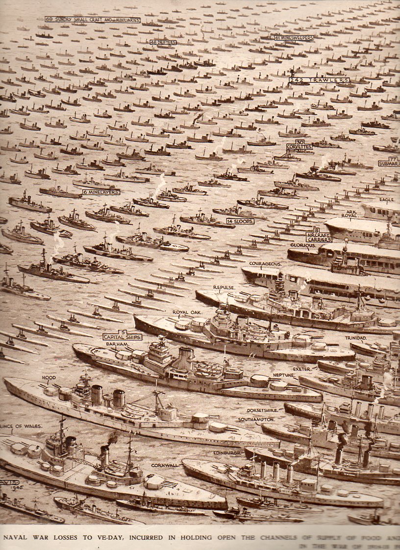
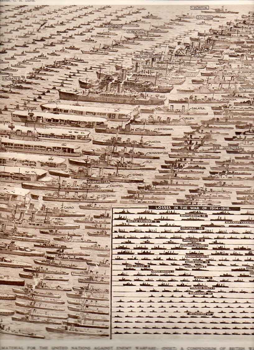
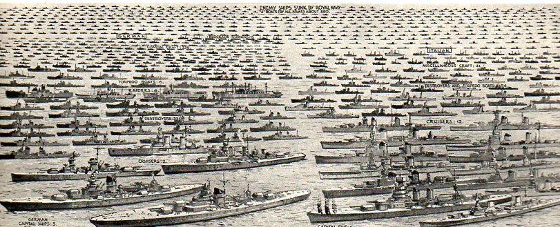
    This enormous, quiet image appeared in The Illustrated London News on 23 June 1945, just weeks after the termination of WWII in Europe.
    Navy Losses--left796Navy Losses--right795

    It graphically presents every ship lost by Great Britain in the defense of “holding the seas against the Axis Powers…holding open the channels of supply and food and war material” from the outbreak of the war to VE day. The inset narrative states that there were on average nearly 3000 British and Allied ships at sea at any given moment, with the Royal Navy patrolling an aggregate  of 80,000 miles of trading routes, day in and day out
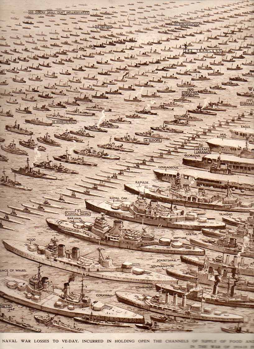
     

    Navy Losses--left796

    It is a symbol of loss, of heroism, of lives not lived, of lives saved, of valor, of greatness, of will, of the cold black sea, of burning oil, of red waves, and above all, of sacrifice. Of splendid behavior. 

    It is a terrible picture of what victory demanded of bravery.        

    It is as much an image of a military graveyard as anything else, a Remembrancer, especially for  those who were never recovered.  It is a grid, a finding aid, a visualizer, for all of those sailors lost in a sea that is indifferent to particular memory.
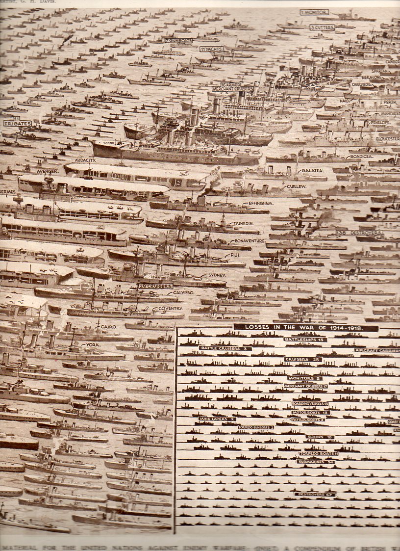
    Navy Losses--right795
    I can’t imagine how this image was received by the Illustrated London News reader on that day.  Did they suck their breath in at the scope of it, of the gigantic reminder of what all of those ships represented?  Was it the sort of image-reading that was forced, a white-knuckle, vacant-chested feeling of sweeping loss?  Of loss and gratitude?  Of gratitude and finding purpose for all of those sacrifices to the island nation?  I suspect that all of those words were in the minds of those readers in 1945–and also for emotions that have no words.  
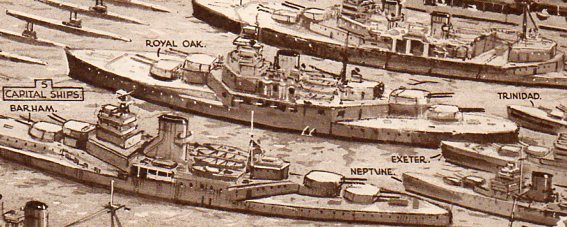
    Navy Losses--left detail797

    Notes:
    There is also a small inset that shows in comparison the Royal Navy losses for WWI, 1914-1918. 
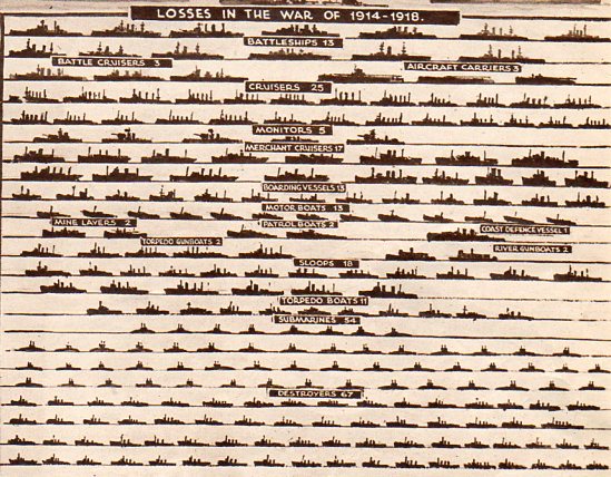
    Navy Losses--wwi798

    There is also this, an incredible single-page display of British merchant-marine war losses of 2570 ships. 
               Navy Losses--merchant marine799

    Both images are the work of the incredible G.H. Davis, who provided cut-aways, cross-sections, maps, diagrams an all manner of information to the ILN readers throughout the war.  HE was an inexhaustible man of excellent design sense.
  • Glorious Gearworks–Model of the Solar System, 1817

    JF Ptak Science Books  Quick Post

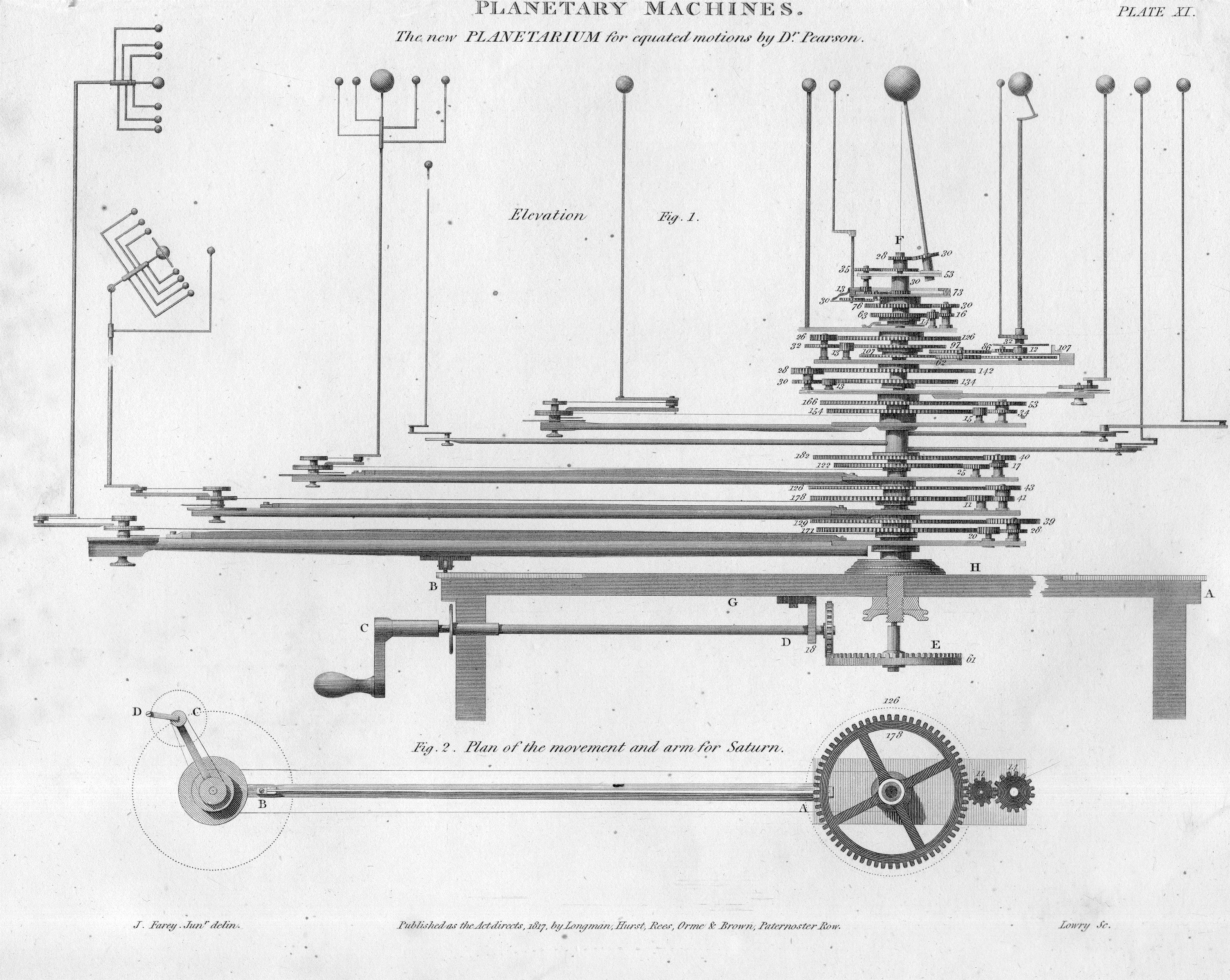
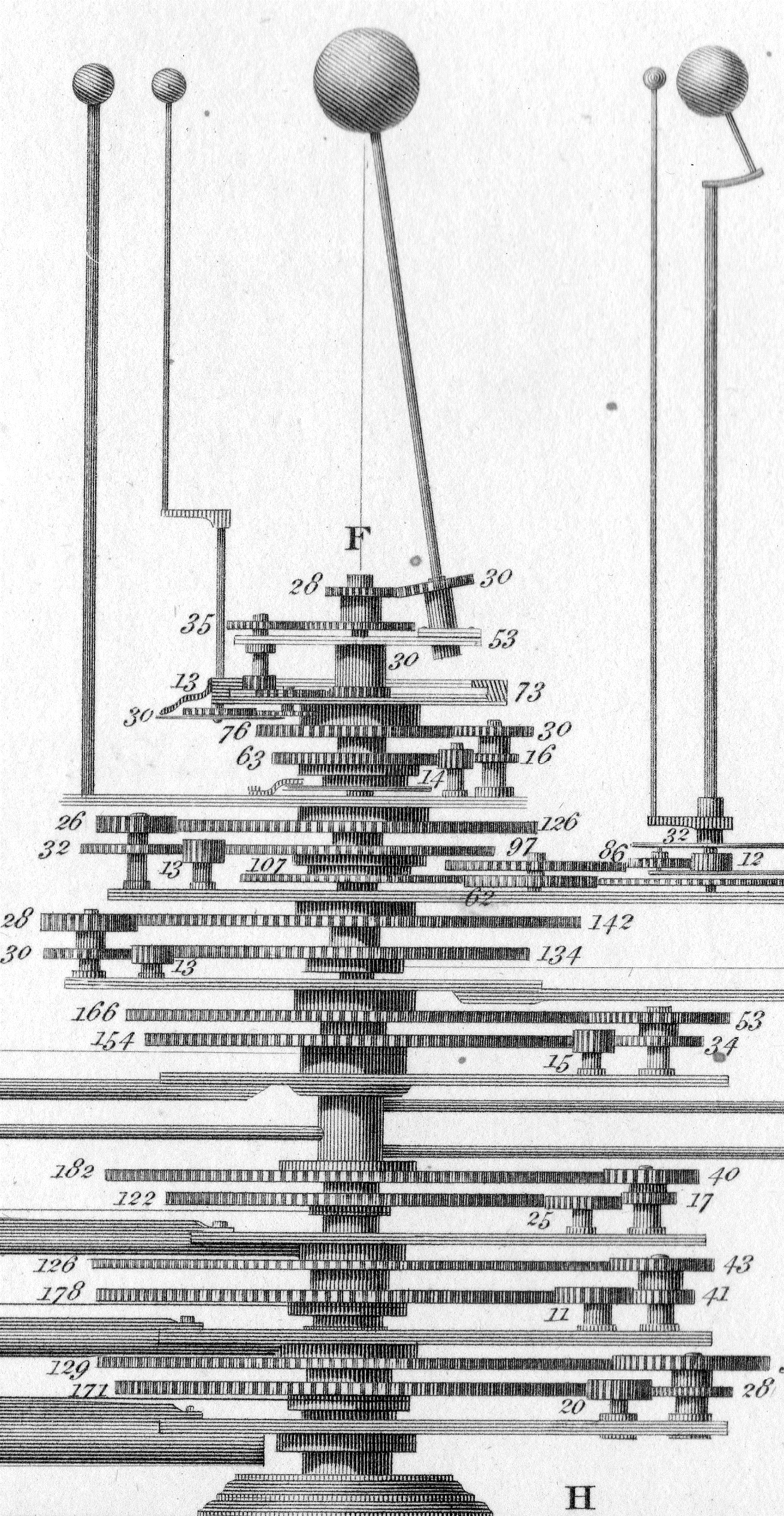
    This is the heart of the beautiful orrey created by William Pearson (1767-1847, and one of the founders of the Royal Astronomical Society) as found in the magisterial if not occasionally problematic Cyclopedia of Abraham Rees (1743-1825). It was published in 1817 and features the main gearing for a mechanical display of the functioning of the Solar System:

    Planetarium916

    This is the detail from the following, full-length version, which is 8″x10″–so there’s a fair amount of detail in a limited field:

    Planetarium914


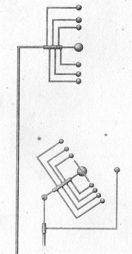
    And the beautiful Dadaist detail of Jupiter and Saturn:

    Planetarium915

    • The original print is available from the blog’s bookstore, here.  
  • Two Very Early Los Angeles Maps, 1850-1855

     JF Ptak Science Books   Post 2443

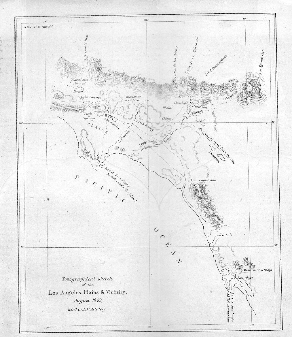
    Well, one is a map and the other is a view, but that is harder to say in a title. They are extremely early for what they are. The first item1, depicted just below, is a map drawn by the accomplished Edward Ord of (mostly) the entire Los Angeles Plains, reaching down to San Diego in the south and up to the“Mission and plain of San Fernando”  in the north. It is a small but important map, one of the very first scientific maps of the region. It is a military map of the area–drawn just after the American conquest–and it is also a gold rush map.  It appeared as one of the illustrations in the first significant scientific work on the California gold rush: Philip Tyson’s Information in Relation to the geology and topography of California, which was published in 1850.  

    • (All of these items are available for purchase via the blog’s bookstore, here.)

    Los Angeles 1850917

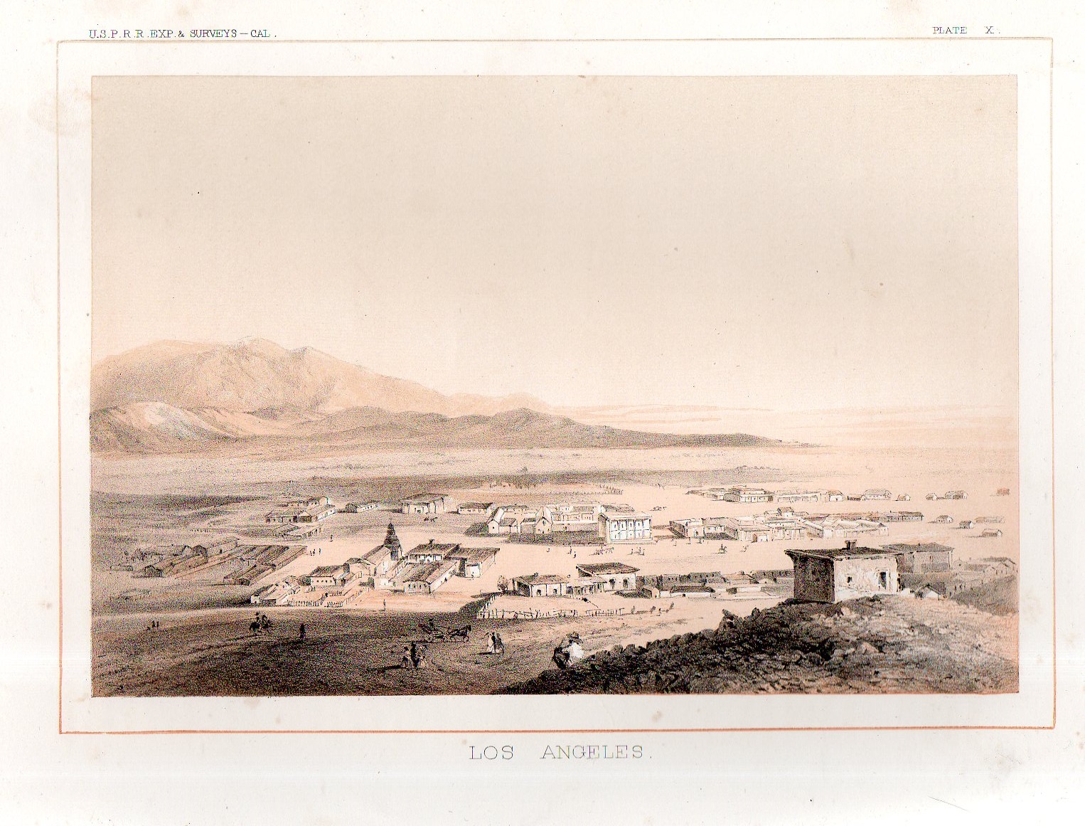
    From the first scientific rendering of Los Angels in 1850 comes the first view of the city–it is tiny by the modern standards of a small time but here in 1855 it was fairly well seasoned and developed, with at least 100 structures.  The first L.A. bird’s eye view appeared in the great survey of possible routes for the transcontinental railway called the USPRR Surveys (or the U.S. Pacific Rail Road Survey2).

    Los Angeles 1855918


    Notes:

    1. See this interesting popular story on the map in  Los Angeles Magazine  http://www.lamag.com/citythinkblog/citydig-the-los-angeles-plains-plainly-sketched/

    Also if you’re interested in reading Ord’s correspondence regarding the map see here in The Army Surveys of Gold Rush California: Reports of Topographical Engineers, edited by Gary Clayton Anderson, Laura Lee Anders

    2. The fuller title: Explorations and Surveys for a Railroad Route From the Mississippi River to the Pacific Ocean…Report of Explorations for a Route…Near the 38th and 39th Parallels of North Latitude .. Volume V , Washington: GPO, 1855. 


  • A Strong U.S. Flag, 1903, and an Alphabet of Advertised Needs

    JF Ptak Science Books    Post 2444

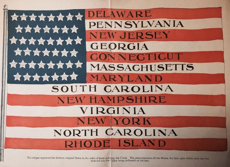
    Aside from everything else in this pamphlet, there is a lovely double-page illustration of a United States flag that is very striking:

    Flag history

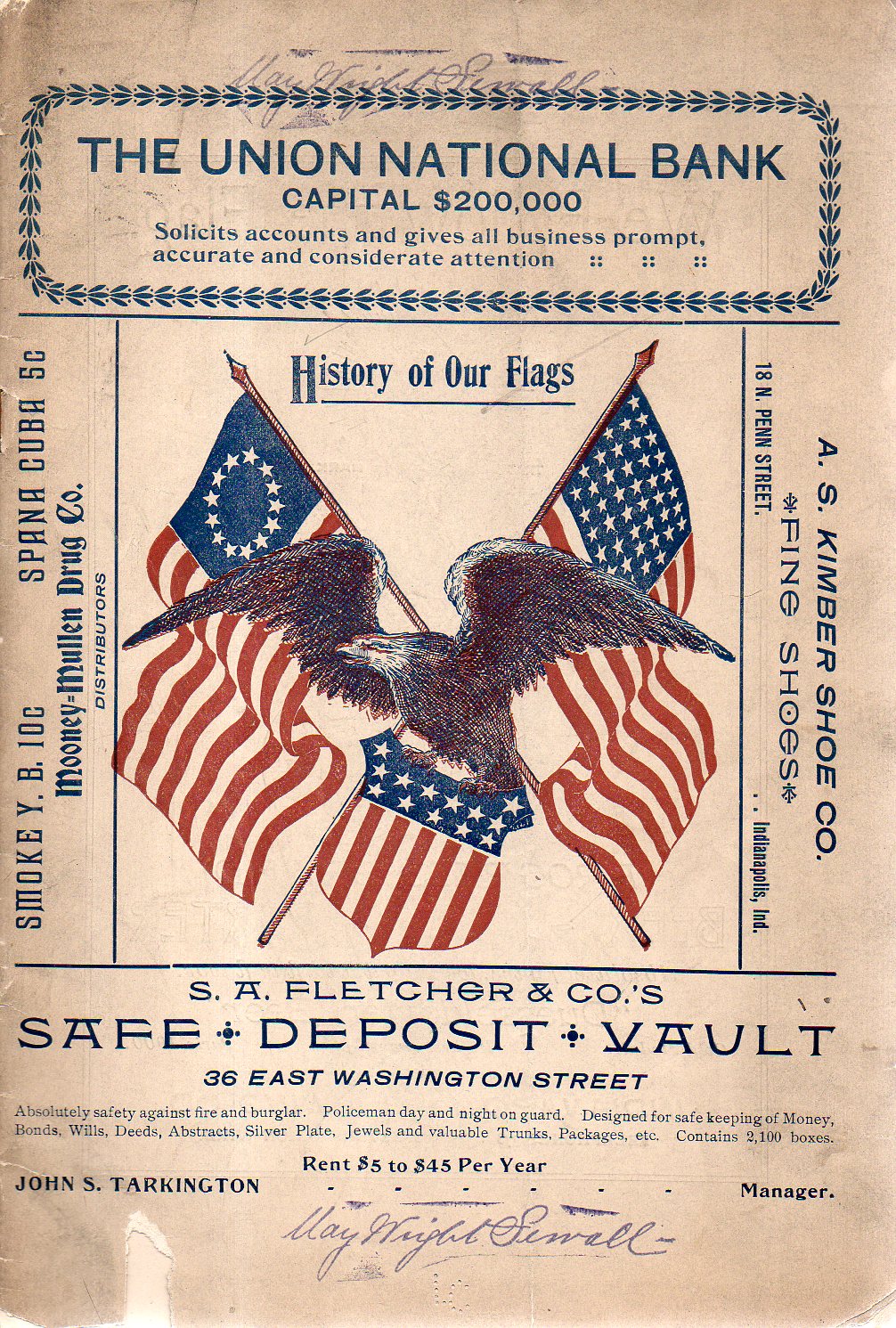
    The other nice part is that the pamphlet–part of my haul of the “Pamphlet Collection”of the Library of Congress some years back–is that it was once the property of May Wright Sewall (1844-1920), who was one of the major leaders in the history of women’s rights in the USA, her influence and leadership spread over several decades. (She was on the executive committee of the  National Woman Suffrage Association from 1882 to 1890; was president of the National Council of Women for the United States from 1897 to 1899, and president of the International Council of Women from 1899 to 1904, among much else.) The pamphlet also has a stamp showing that it was donated from the Sewall estate by her literary executor in 1923.

    • This item is offered for sale via our blog bookstore, here.

    Flag Sewall919

    The other bit that strikes me are the ads which are everywhere on the pamphlet–from crowding out the title on the front cover to loading up the interior pages; the work does have some nice illustrated history of the flag which is engulfed by ads. It is interesting to look at the ads to get a bit of an idea of the geography of need-and-satisfying it:   

    A Near Alphabet of (100+) Advertisers  in the 28pp document include:

    • Bailing Machines
    • Beer Dusseldorfer Beer–we follow the flag! (“Telephones 576”)
    • Beer (“American Brewing Company” Telephones 407″)
    • Boarding, Feed and Sale Barn 
    • Books (“Blank books and stationery”)
    • Canned Fruits from Ko=We=Ba
    • Carriages (“The Co-operative Carriage Co.”)
    • Clay working machinery (from C.A. Potts)
    • Coal, Coke and Wood
    • Dental College of Indiana
    • Electrical Supply 
    • Flour, Grain and Hay from the Wm Rouse & Son central elevator
    • Groceries (“Groceries, Meats and Canned Goods, always fresh”)
    • Iron work 
    • Jewelry
    • Lumber & Shingles
    • Millinery
    • Oil and Supply for the mill
    • Pharmacy 
    • Pianos
    • Pianos, player (from “the Aeolian Company”)
    • Pulleys, Paper
    • “Pictures and Picture Framing”
    • Regalia (“The Indianapolis Regalia Co., for Lodge Regalia, Costumes, Flags, Badges, Banners”)
    • Rocking Chairs (and go-carts and children’s carriages)
    • Safe Deposit Vault
    • School (“Knickerbocker Hall, Boarding and Day School for Girls”)
    • School (“Girls’ Classical School”–this is actually a school run by Ms. Sewall)
    • School (“Tudor Hall School for Boys”)
    • Shoes
    • Stationery
    • Tailor
    • Tin, sheetwork and furnace work
    • Undertaker
    • Upholstery
    • Wagons
    • Water (“Indianapolis water Co supplies excellent water for domestic use”)


  • An Excruciatingly Detailed Map of Los Angeles, 1903

    JF Ptak Science Books   Post 2445

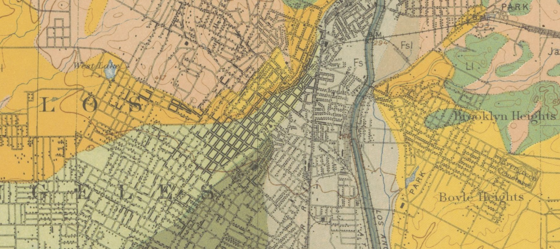
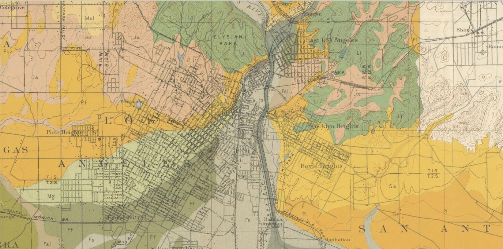
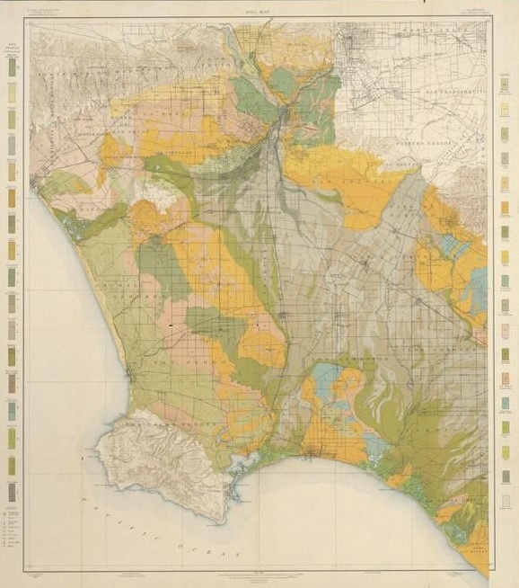
    Soil survey maps have long been favorites of mine–not because of the soils part (which is a fascination all on its own) but for the terrific amount of human geography.  The maps are usually quite large and cover areas that are quite small (relative to other maps), and the folks who went out to collect the data also helped to collect much of the human-impact stuff as well.  Not only are roads and canals located, but so are distant farmhouses and barns. As you can see in the first detail ,individual structures are located along the streets in LA central.  The maps are really pretty extraordinary.  

    LA Soil Map 1903  Really big detail

    [Mesmer, Louis. Soil map, California, Los Angeles sheet., Map, 1903]

    And a bit lesser detail:

    LA SOil Map  1903

    And the full map:

    LA SOil 1903 Full

    This copy is NOT my copy of the map–it is simply too large for me to digitize. The copy that I’m working with above is from   Texas History, with a fine, full, interactive and very zoomable map, here:  http://texashistory.unt.edu/ark:/67531/metapth193395/m1/1/zoom/

    • “Map shows soil composition, roads, railroads, city and town street layout, structures, and watershed. Includes soil profile and legend. Relief shown by contours and spot heights. Scale [ca. 1:62,500].”–from the Portal to Texas History website (as above)  Baltimore : A. Hoen & Co. Lith, 1903. 35×30″

    That said, I think my copy is in better condition, and can actually be purchased from the blog’s bookstore, here.  

  • Unusual Cross Section of Dirigible, 1929

    JF Ptak Science Books  Quick Post

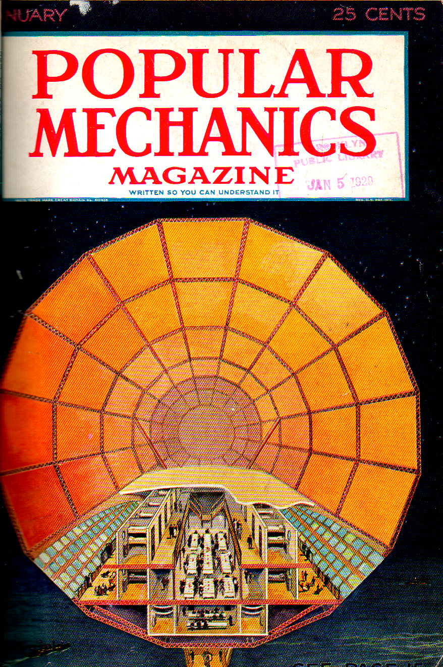
    I’ve seen other straight-on cross sections of lighter-than-air aircraft before, though seldom have they been at night, and seldom in color, making this one fairly unusual to my experience.  

    Dirigiv=ble 1929924

    Under discussion in the article were the current great lighter-than-air ships and their future. Mentioned prominently were the Graf Zeppelin (which flew it first intercontinental flight just months earlier in October 1928 (and which flew until 1937)), and the British R-101, which was under construction at press time of this article, and which would crash and burn in its maiden voyage in October 1930. But in 1929, with these great new developments, and with airplane service across the ocean still seemingly in the relatively-distant future, the future of the dirigible looked pretty goo.  But even by 1932 the great Graf Zeppelin’s service would be extremely curtailed by the new airplane services, and by that point the days of the dirigible were numbered–especially come May 1937 when the Hindenburg crashed (and burned) so spectacularly.

    Again, January, 1929, was a good time for the dirigible–but hundreds of days later, the situation would be reversing. 

  • Can You Volunteer and Work for the Nazis and Not Be One?

    JF Ptak Science Books    Post 2411

    “I am the first woman to make a flight across London, in one of His Majesty’s war machines; I am the first woman who has been presented by the War Office with a view of Hyde Park from an altitude of almost eight thousand feet.”–Jane Anderson (1916)

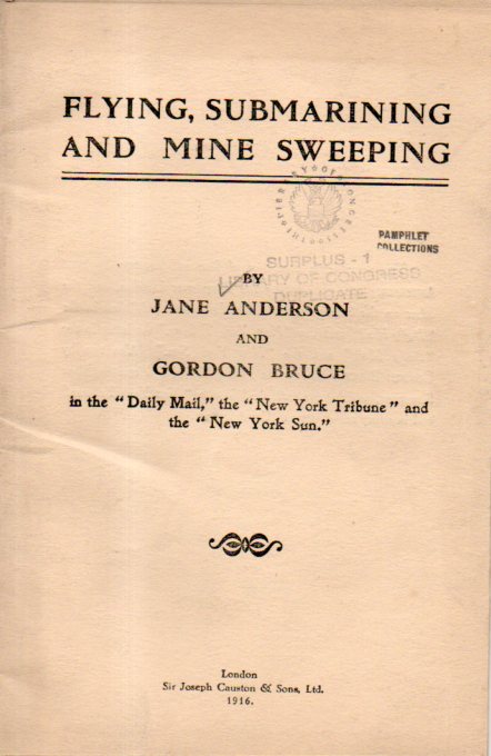
    I was somewhat surprised to see that this pamphlet was co-written by a woman—my 
    experience with WWI pamphlets is that it is vastly dominated by male writers, and I
    would have expected it to stay so especially for this subject matter. Jane Anderson was an
    interesting writer with a free style, and I can tell that she had a good time with her
    experiences. She starts with this, and tells an unusual story in an easy way:
    WWI Pamphlet Female727
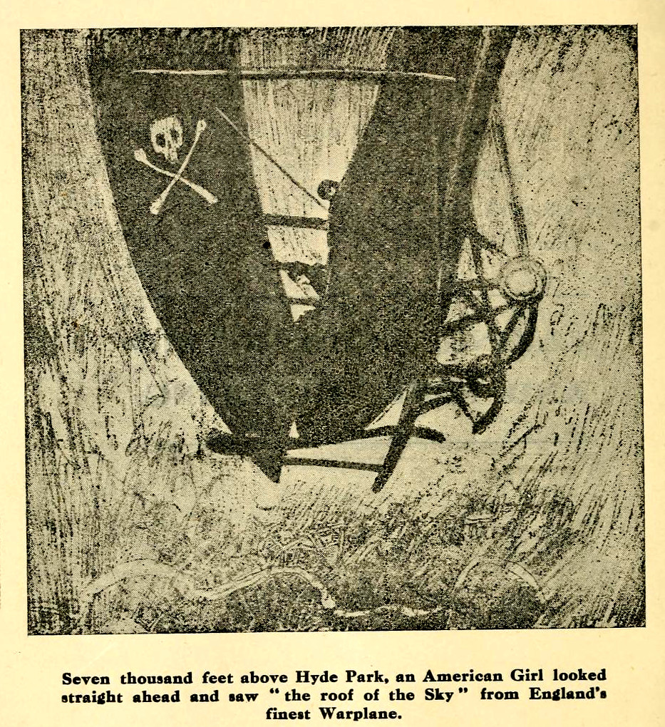
    “Seven thousand feet above Hyde Park, an American Girl looked straight ahead and saw "the roof of the Sky" from
    England's finest Warplane.”
    Flyingsubmarinin00ande_0004
    An example of her writing on the sub: "When I looked at her lying with her exposed tubes shining in the sunlight and her bulkheads in strips of rusty
    iron, it seemed incredible that she had been under the coast guns of the enemy, that she could have made
    in her damaged condition a journey of three hundred miles, returning to a safe harbour with the information
    she had been sent to obtain. And, added to this, was the fact that she had made the voyage in a high sea,
    that for twenty hours, defenceless, she evaded the enemy patrols....”

    The pamphlet really is worth a read, and it is available here for free via the Internet Archive.

    The second part of this story is not so great--checking Ms. Anderson's biography
    reveals an ugly twist and deep turn to the far and distant fascist/Nazi right. She was 
    certainly an adventurer, and at some point she winds up marrying nobility in Spain
    and covers the Spanish Civil War--but she goes from journalism to propaganda
    and begins to write and broadcast for the Fascist government. Her good works there
    come to the attention of the Nazis, who pursue their interest in her. Anderson responds,
    and goes to work in service of Adolf Hitler. She writes propaganda, and then is given her
    own radio show. She seems to have been useful for a time, and then perhaps wasn't, but
    she stayed in Germany until the end of the war, arrested after flight finally in 1947 in
    Austria. She was charged with treason, but released for lack of evidence.
    She survived herself, went to Spain, and lived to be 84, dying in 1972.

    From Wiki, we have her wartime story:

    ·Posted by :

    ·in:

    — —
  • Tiny Sky Nets for Attacking Aircraft, 1925

    JF Ptak Science Books   Quick Post   Atlas of Dead Ideas series

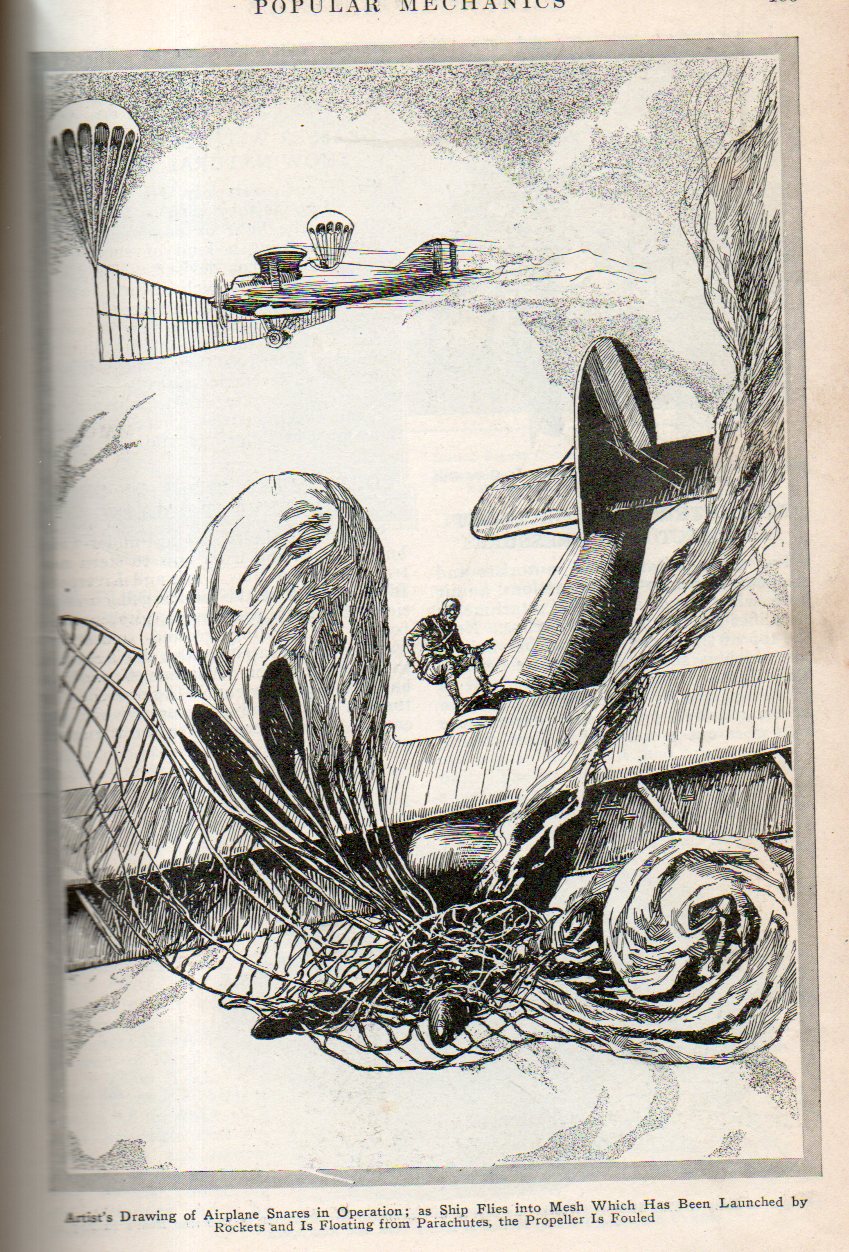
    “Nets Launched on Rockets to Snare Airplanes” ran the header on this article from Popular Mechanics (volume 44, July 1925). “Nets fastened between parachutes and shot high into the air with shells or rockets are being tested by anti-aircraft branches of the Japanese army and navy as snares for airplanes…”  Evidently the plan was to locate the approaching plane and fire these things in their vicinity and hope for the aircraft to find and run into that speck of net occupying .00001% of the sky.  

    Airplane snare738

  • Visual Display of Data: German Military Weakness, 1929

    JF Ptak Science Books   Quick Post

    Military graph canons734 bug

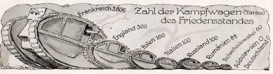
    In 1929 Germany was still abiding by the Treaty of Versailles, which was the peace treaty ending WWI and signed in 1919. The 440-clause treaty spent the first two dozen or so clauses were spent on President Wilson’s League of Nations, while the rest was a distribution of punishment and reparations against/on Germany.  The German military as directed by Versailles was limited to 100,000 soldiers, and had 1926 machine guns, and 2886 cannons.  as stipulated Germany could have no tanks and no air force, and was limited to six ships and no subs, and had to keep the Rhineland free of all armed forces.  

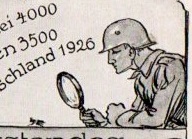
    By 1928 Germany was certainly having multiple regressive thoughts about the Treaty, and public demonstrations of questioning its efficacy began to appear with more frequency.  In this example–from the Illustrite Zeitung (Leipzig)–a strong statement was graphically displayed showing the state of the German military situation.  As you can see, there is scant measurement for just about anything in the military sphere for Germany–and to press the matter home ever more so, in addition to the nulls and tiny numbers, there (in the sixth section down, and magnified above) is a helmeted German soldier with a large magnifying glass inspecting the German totals of the nearly-invisible machine gun totals.  

    This would all be completely changed by 1934, when the Nazis were already well on the way to having a competitive (and modern) fighting force which counted 4.5 million troops.  It would only get worse.  

    Illustrirte Zeitung, 1928:

    Military graph canons732


  • Floating and Airborne Airports, 1925

    JF Ptak Science Books  Quick Post

    Airport aerial740


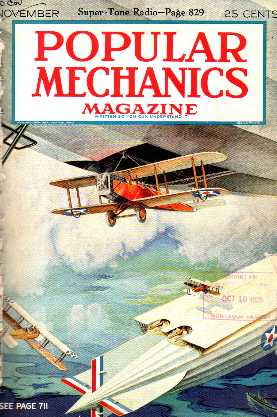
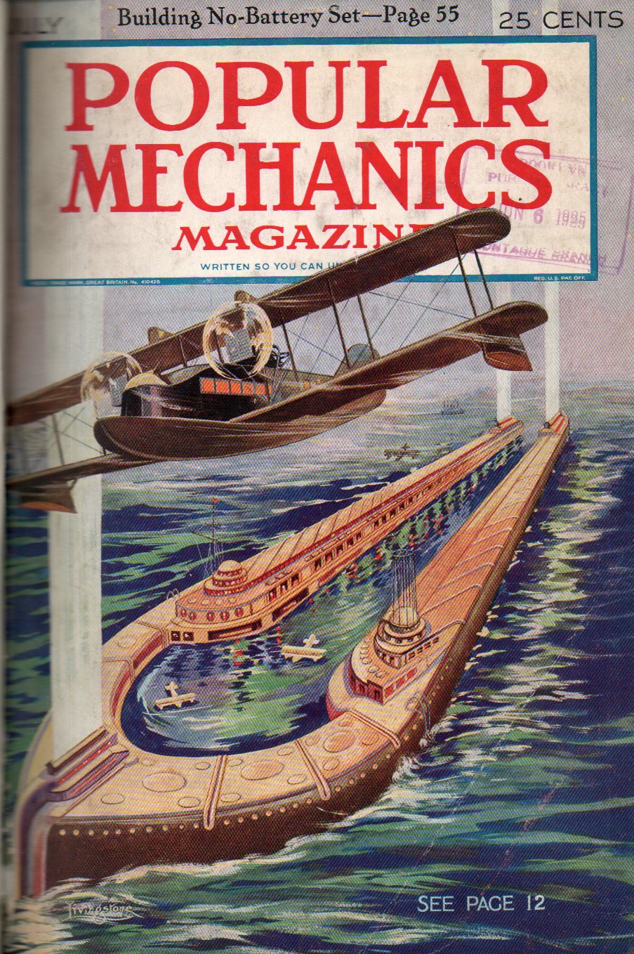
    One of the great dreams of early modern flight was to get across the Atlantic. In the decade+ before the first non-stop transatlantic crossing many plans were presented for making it across the Atlantic with stops. The problem of course was where the “stopping” would take place. Popular Mechanics presented two of these ideas in 1925: one was the floating airport, a series of four 1200′ long and 250′ wide aviation harbors on the high seas, four of which would be necessary to get aircraft across the ocean.  The other were aerial sky harbors, with zeppelins outfitted as aircraft carriers in the clouds.

    Airport floating739

    These proposals look like less-than-fresh ideas in 1927 when Lindbergh makes his flight, and obsolete by the early ‘thirties when several airlines offered transatlantic service.  Anyway given the available technology the ideas were not half-bad, though the technology would overtake the necessity for these ideas idea pretty quickly.  Considering that we go from the Wright flight in 1903 to transatlantic flight in 30 years, the speed of technological advancement was really pretty extraordinary. 

    Also from this blog see:


  • The Not-90′-Long Slide Rule

    JF Ptak Science Books    Quick Post

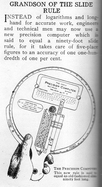
    I bumped into this short notice in the magazine Illustrated World for May 1916 and at first didn’t recognize the instrument.  It turns out that it is a skeleton drawing of the Ross “Precision Computer”, an 8″, multiple circular spiral (with 25 windings) circular slide rule.  It might have had the same effectiveness as a 90′ slide, though I read something elsewhere that it was more like 60′.  In any event, it was made of metal, and glass, and celluloid, and was an effective and elegant instrument. 

    Computer precision742

    [Illustrated World, May, 1916, page 388. Apologies for the fuzziness–the book was too thick and too old to force it flat on the scanner.]

    For more information as well as a photo of the instrument, see the Smithsonian Institution entry here:  http://americanhistory.si.edu/collections/search/object/nmah_690756

Recent Posts

Archives

Categories