JF Ptak Science Books LLC Post 262
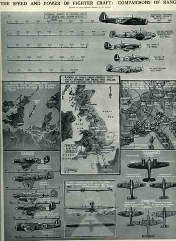
These four images represent some common, popular distribution of
information to the general population, the sets of two working at cross
purposes. (I’ve written several posts here about the Nazi use of maps as a propaganda tool; if you search this blog under those terms you’ll find several entries.) The British images were issued just after the start of WWII
(30 September 1939) and then again just after the end of the Battle of
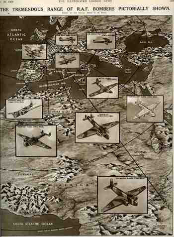
Britain (November 1, 1941), respectively. The first (“The Tremendous
Range of RAF Bombers Pictorially Shown”), illustrates the range
capacity of its long range bombers for WWI and for 1939, showing how
far they could strike into the heart of Africa. I’m not so sure why
Africa was chosen as the target, as nothing at all was happening there,
militarily speaking, at this early stage of the war; why this didn’t
show the planes screaming their way to the east is a mystery to me.
The Home Office was busy showing how far the Wellington bomber could
reach (3,240 mles), as well as the long shadows cast by the Hampden,
Sunderland and Wellesley. The second British image, “The Speed and
Power of Fighter Craft, Comparisons of Range” displays aircraft of the
principle RAF and Luftwaffe fighters and bombers.
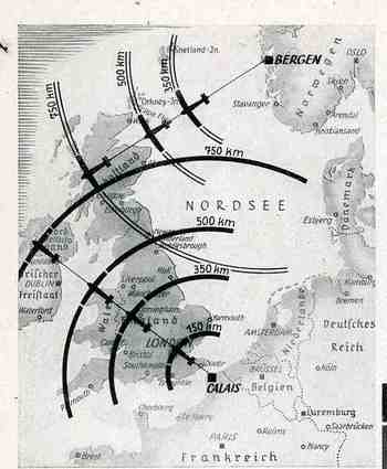
The first German image, printed as a small inset map in a general propaganda piece in the Illustrirte Zeitung (Leipzg), for November 1940, depicted the capacity of the Luftwaffe to reach, threaten and bomb any region in the British Isles from bases in Calais (France) and Norway, having secured the positions in their attacks against the two countries in Fall Gelb and Operation Weserubung respectively. Britain was effectively half-surrounded from these positions from the Brittany to the Norwegian coasts.
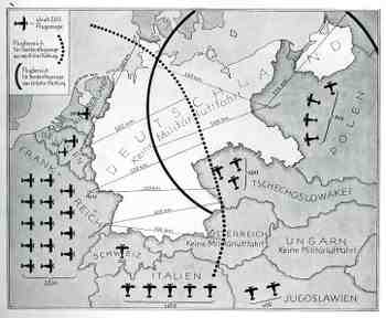
The second German map (and the fourth presented here) is another interesting fiction coming from the propaganda offices in 1938, showing how Germany was threatened by attack from the air forces of its neighbors. Particularly pungent in this portrayal was the threat from Checoslovakia, Yugoslavia and Poland.