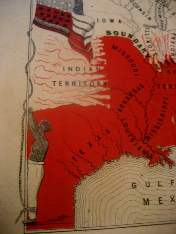
 This incredible, indelible image is another from our collection of graphical representations of data and ideas. This map, is entitled Moral Map of North America, 1854; the Slave States are coloued Red, the blighted influence of Slavery is also deeply felt in those parts more slightly streaked with Red. I can find no record of this map, printed obviously by our Bretheren across the ocean–that and the fact that it was printed in 1854 is all the publishing data that I can find.
The poem at bottom reads:
United States! Your banner wears
Two Emblem one of Fame;
Alas! The other it bars
Reminds us of your shame.
The white man’s liberty in types
Stands blazoned by your stars;
But what’s the meaning of your stripes;
They mean your Negro-scars.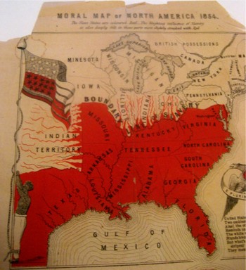
Reciting this poem by Thomas Campbell before an abolitionist convention in 6 March 1851, William Wells Brown continued (as was reported in the National Anti-Slavery Standard) “The name of the United States is becoming a hissing and bye-word in the mouths of the inhabitants of every clime. My country is indeed the land of oppression. There is not a rood of territory over which the Stars and Stripes fly, on which William and Ellen Craft or myself could be protected by law. Wherever the American flag is seen flying on the continent of the New World it points us out as slaves; and we enjoy to-night a degree of freedom in your town that we could not if we were in the land of our birth. I often speak of America as my country, but in point of fact I have no country. In the language of one of the noblest of the Negro’s champions in the United States. My country is the wide, wide world; My countrymen are all mankind.”
Brown should know: his mother was a slave and his father the plantation owner who later granted him his freedom. Brown then worked the underground railroad and much, much more, working with William Lloyd Garrison and Wendell Phillips. Among his published works included the incredible Clotel, (1853), which was one of the first novels published by an African-American in the U.S., and which discusses in great detail the relationship between Thomas Jefferson and his slave/lover/mistress Sally Hemings.
The map is definitely a tale of morality, showing a definite margin of slavery but also depicting slavery leeching its way through the border states. It is interesting to note that Washington D.C. is represented in red as it was indeed a slave-holding district, with a slave pen right on the Mall in the 1830’s.
The most striking feature to me of course is the slave who is lashed hand-and-foot to the flagpole on which the American flag is flying—this is the only time that I have seen the slave and the flag portrayed as a unit, together, the slave being tortured by the standard of our country.