JF Ptak Science Books LLC Post 676 Blog Bookstore
The idea of the frontier in American history
has been around for quite some time, made famous and mostly-invented (and
closed) by Frederick Jackson Turner in 1893, and expanded, imagined, enticed,
magnified, micro-analyzed, and generally messed with ever since. There have been all sorts of frontiers
introduced into the study of the birth, expansion and filling-up of this
country, from the very earliest colonial periods of Indian frontiers, “far-western”
river frontiers of the Connecticut, Delaware, Hudson (!) and Susquehanna, to
the Appalachian frontier of the early western reaches of the colonies, to the
transportation frontier, the slavery frontier, the gold and mining frontier,
the gun frontier and so on.
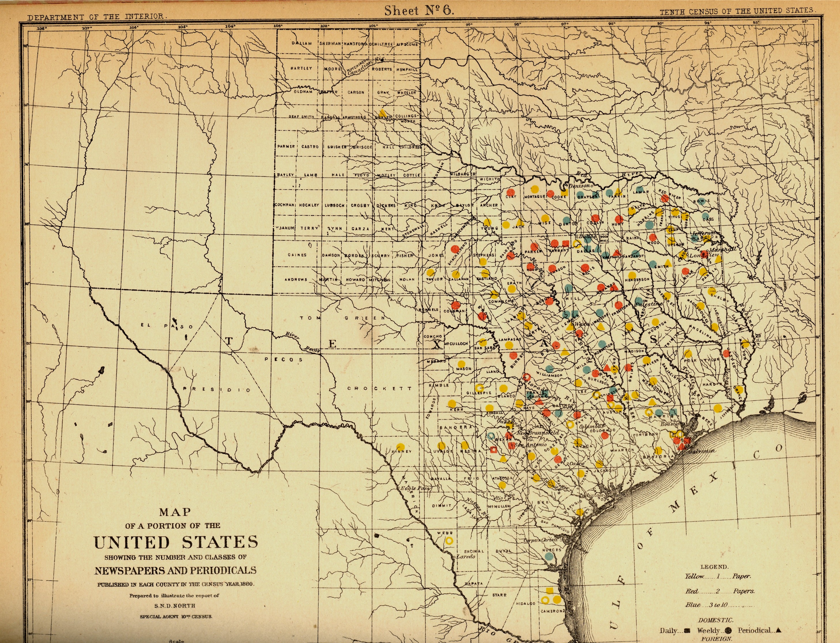
I’ve got another bit to add: the newspaper frontier.
I just happened upon a volume of the US
Census of 1880, with a special report by S.N.D. North entitled History and Present Condition of the
Newspaper and Periodical Press of the United States…and published in
1882. What provoked me was the map of
1880. It very clearly, and like no other
map of its kind, delineates a fantastic line/frontier between the Texas
clearly that the frontier of the newspaper stops fairly abruptly and
wonderfully at the 100th meridian, with only two newspapers in all of
the rest of
mostly marks the vertical middle of the country, running through North and South
Dakota, Kansas, Nebraska, the Texas/Oklahoma borders, and so into Texas—if you
folded this map vertically in half it folds virtually on the 100th meridian. An odd bit, it is, half of the country and
then half of Texas
are located east of this point, I know, but it is still quite a jolt to see the
line of newspapers get drawn in the sand so vividly. There isn’t anything else quite like this so
far as the newspapers go, except, a little, for Florida, where the line gets
drawn north and south, splitting the peninsula roughly in half, the southern
part holding only five counties at this point..
But it is a much more robust image for Texas given the number of
newspapers that were being published—280 periodicals and newspapers for Texas
versus 45 for Florida, with 11,374 in the entire country*—so that the
difference between the have-newspapers and haven’t-newspapers in Texas is that
much more vivid.
Texas needed more papers: there were 1.5 million people living in the
massive state in 1880, almost twice as many as there were in 1870, and almost
half of what there would be there in 1900.
Florida was another story, entirely—even in 1880, which is only 130 years ago, there
were only 270,000 people living in the entire state, not even close to half of
the county population of Pinelas today.
straight-edge frontier in Texas
*Just for the sake of comparison, the number
of periodicals per state for 1880 was as follows: Illinois,
1017; New York, 1411; Pennsylvania,
973; Ohio, 774; New
Jersey 215.
Also, oddly, the average circulation of the Florida and Texas papers was roughly the same: 1,282
for Texas and 1306 for Florida (with an average for the country at
4137).