JF Ptak Science Books Post 1738 [Part of a series on the Display of Quantitative Information]
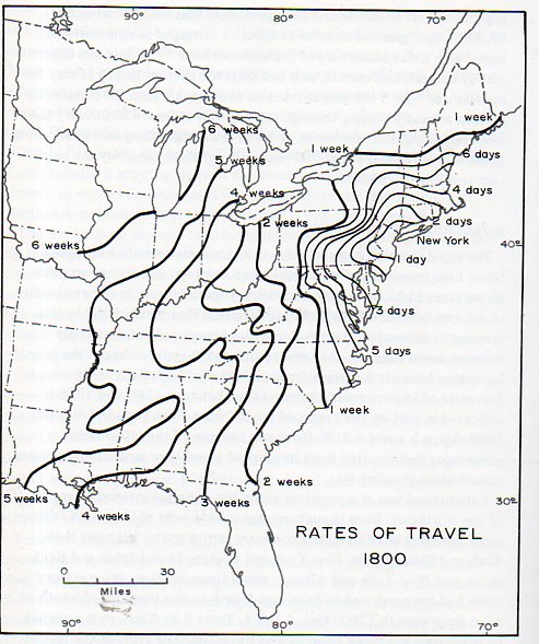
I wanted to pass along these very interesting maps that appear in Allan R. Pred Urban Growth and the Circulation of Information, 1790-1840 (Harvard, 1973) because they give a quick and elegant view of how long it took to get to various parts of the country in the first part of the 19th century.
First, Rates of Travel, 1800:
and its complement, Rates of Travel 1830:
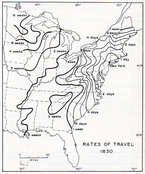 [Note: all travel time based on starting point in New York City.]
Its interesting to see with just improvements in travel excluding the introduction of railroads and (for the most part) canals that travel time was basically cut in half in about thirty years’ time. For example, in 1800 it would take roughly four weeks to get to New Orleans, and then six weeks to arrive in Iowa and the Upper Peninsula. By 1830, that time was two weeks to NO, and three for the other two locations. In 1800, it was a five day trip to the northern Outer Banks in North Carolina; that would be cut to two days by 1830. The trip in 1800 to the vicinity of Savannah and the northern part of Florida was a two week ordeal; by 1830, that time had fallen to 6/7 days. The Mississippi was reachable in five weeks in 1800; in 1830, that time was cut to two weeks. This as I said would all change drastically over the next three decades, once the railroad system became slightly mature.
And here, expanded to 1857:
By 1857 one day’s travel time has been blasted to a ring encompassing the southern half of Maine, partially into Ohio and south into the northern part of North Carolina. Two days of travel will get the traveller deep into Michigan and parts of Wisconsin, and half-way through North Carolina and South Carolina (excluding the mountain region in Western NC). Three days will now get us to northern Florida, halfway through Georgia and Tennessee, and into the Midwest, past the Mississippi River. Beyond the basic reach of the railroad at this point is the rest of the country, and harder going, though one week of travel will get you deep into the central part of the country, where with some difficulty you would be able to find your way to southern California in three weeks, and the Pacific regions of Washington Territory in six weeks–basically, an entirely new world of travel and the spread of goods, service and information, not the least of which was aided by the spread of the railroads, which increased from 3,000 miles of track in 1840 to more than 30,000 in 1860.
Again, I really just wanted to share this display of information because I have found them to be useful in the past, and the info doesn’t seem to be all that wide-spread.
My source for the maps has been varied from web sources, but the original work seems to have been published in Charles O. Paullin and John Wright, Atlas of the Historical Geography of the U.S., published by the Carnegie Institute of Washington, D.C. (1932), pages 138a, 138b, 138c, 138d.