A Daily History of Holes, Dots, Lines, Science, History, Math, Physics, Art, the Unintentional Absurd, Architecture, Maps, Data Visualization, Blank and Missing Things, and so on. |1.6 million words, 7500 images, 4.9 million hits| Press & appearances in The Times, Le Figaro, Mensa, The Economist, The Guardian, Discovery News, Slate, Le Monde, Sci American Blogs, Le Pont, and many other places… 5000+ total posts since 2008.

Category: Maps, Cartography, History of Mapmaking

  • Map of Newsboy Work Violators, 1915–Child Labor & Child Scavengers

    JF Ptak Science Books   Post 1330 [Part of a developing series in the History of Normalcy]

    “There is work that profits children, and there is work that brings profit only to employers. The object of employing children is not to train them, but to get high profits from their work.” — Lewis Hine, 1908


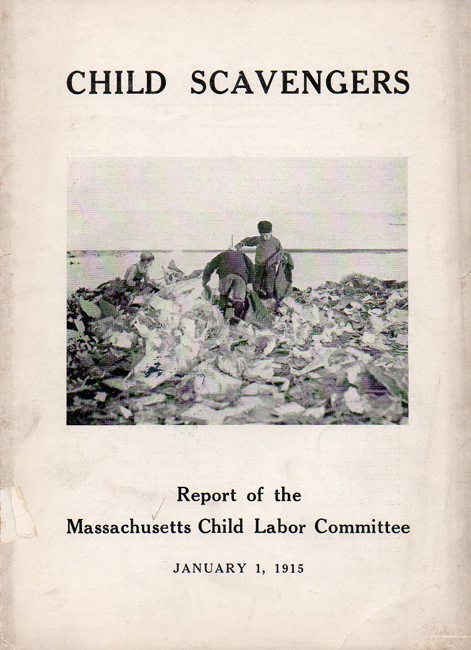
    As rudimentary as the title of this pamphlet seems, it isn’t really quite so, not really completely in the column of not having child laborers and exploiting children.  There is a degree of exploitation allowable–yes it was a different time–and the map that I’ve plucked from this work shows the extent of rough-edging of the law that was tolerated.  The authors weren’t so much concerned that there were 2500 newsboys in Boston-proper hawking newspapers morning/noon/night, but rather that they found over a third of them weren’t wearing their Newsboy Selling Badge when confronted.  And it wasn’t that they were under-aged–just that they were badgeless. 
    Child scavengers362

    On the other hand, the Massachusetts Child Labor Law Committee cited unidentified “critics” (and I don’t doubt that there were many) saying that “children don’t work enough nowadays, and that child labor laws have left nothing for children to do, especially in the cty where there are no chores”. (This work is available for purchase from our blog bookstore.)

    And they did do a study of child scavengers, reporting that in “one dump in a Massachusetts city fifty-five children from five to fourteen years old were moving slowly over an acre of rubbish…” The authors report (unfortunately without reference) that in one Boston school distict of 2,128 children that 125 of them “do this work”, and that 500 children in Boston “are so engaged”.  This didn’t include the children who “gathered refuse” from martketsm freight yards, and ash barrells”  or who were sent out collected odd bits of dropped wood and coal. 

    Child scavengers map363

    But the fact of the matter is that these folks were just knocking at the big door of child labor reform, a big piece of which would come into being in the next year (1916) with the Keating-Owens Act, which began the strict reulation of child labor, defining what the terms “labor” and “child” were. (The act restricted minig occupations to children 16 and over, and for 14 years of age for the manufacturing industries; no night work was any longer permitted, and the work day was limited to eight hours.  This was the reform, so one can imagine what the labor was like before this legislation.) In 1890 there were something like 1.5 million children in the workforce, a figure which was raised to 2 million by 1910, and which was nearly halved (because of awareness and federal oversight) by 1920.

    Lewis Hine (1874-1940)–who gives us the quote to lead this short post–was a school teacher and sociologist  who was extremely aware of the plight of the children around him–well, children, and immigrants, and laborers; people without voices, or representation, poor working people.  He was a pioneering photographer whose images of these classes of people were revoltuionary, a tremendously important documentarian of a societal symptom that was pretty much misdiagnosed, or at least was chosen as something to not be seen.  That was hard to do when you had actual photographs of the grim situaiton. 

    Trodd-lewis-hine-01

    This could’ve been my grandmother. At about this same time. 

    File:AddieCard05282vLewisHine.jpg

    Hine also made some of the most  iconic labor images in American history, a vastly underappreciated heroic figure duirng his lifetime.


  • The Rare Antique Vision of Looking Straight Down

    JF Ptak Science Books   Post 1295

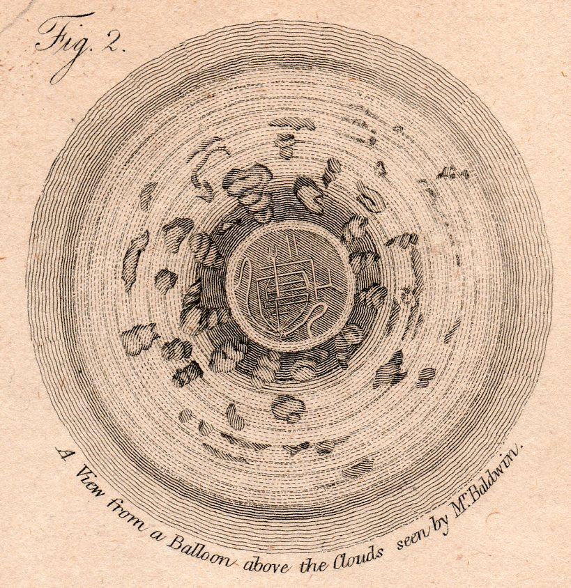
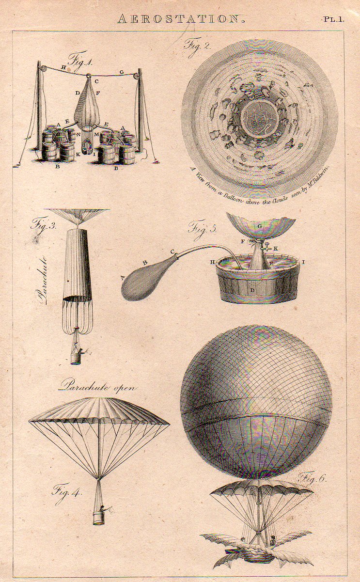
    The idea of representing a view straight down, of looking straight down from some height, is a relatively recent occurrence, this view being somewhat rare in the antiquarian world pre-balloon or pre-heavier-than-air flight.  The pre-human-flight reason for its scarcity is understandable, but even after the first Montgolfier ascension in 1787, there’s another 120+ years of scarcity yet to come before these views would start to pop up in common (and uncommon) literature..  Now I’m not talking about cartography, which is basically a straight-down view of the world—what I’m referring to is that same view but not as a map per se, but what you would see if you were dangling out of a plane or balloon.  The extraordinary map of Imola by Leonardo would certainly classify because of its you-are-there qualities:  essentially it would be like a bird’-eye or oblique view, but straight down.

    All of the images are available to purchase from our blog bookstore, here. 

    The first image is that made from a balloon, a lighter than air affair, and engraved and printed around 1810 or so.  It has a very uncommon vertigo-ey affect, like a map of Dante’s leveled creations, though what we’re seeing is a very 

    Looking str8t Diwn-balloom det220 

    …which is a detail from this engraving, made in London around 1810. 

    Looking str8t Diwn-balloom219

    There are of course a number of other lovely design elements, not the least of which is the man in the parachute, bottom left.  (My guess is that the flag held by the man was not for patriotic reasons but rather for more practical concerns, light judging wind strength and duration.   

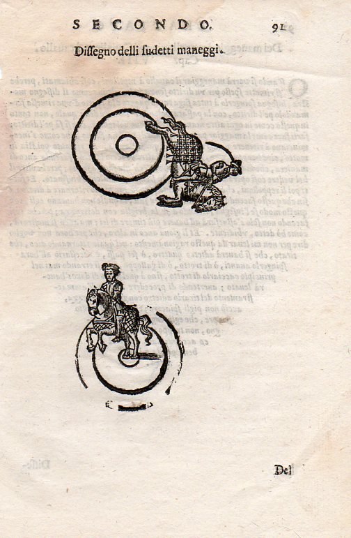
    Another interesting image is this instructional from a source printed around 1620 (I don’t know the source here, either–I purchased the print loose many years ago like many of the others here at Pageant Bookshop in NYC).  It shows a slightly oblique angle (below) and then the flat-perspective view at top: 

    Looking str8t Diwn-horse221
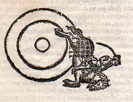
    And then the lovely detail:

    Looking str8t Diwn-horse222

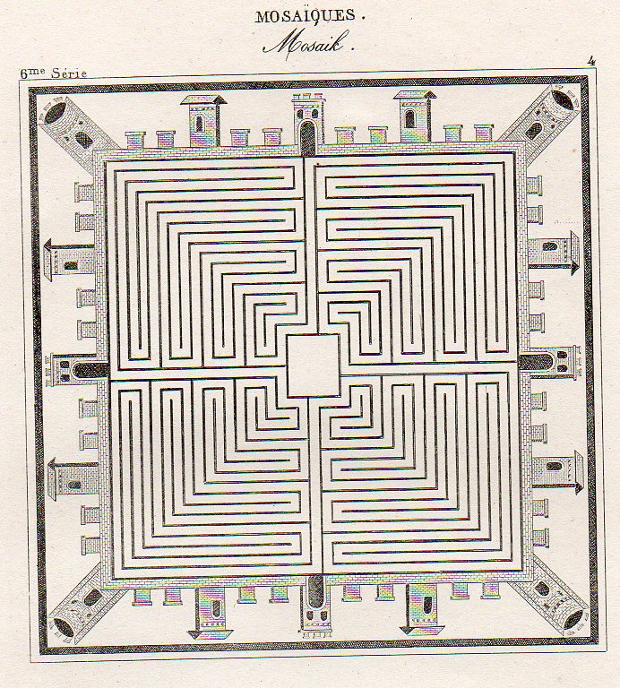
    Then there’s this beauty, showing an idealized town square, presented in mosaic as though seen from above, continuing this thread of flat-perspective–basically looking at some central part straight down, and then taking the objects surrounding the central figure and simply laying them on their backs, as so):

    Looking str8t Diwn--mosaic218

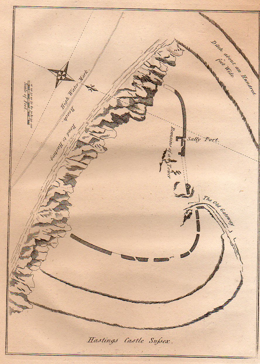
    Lastly for now is this quite flat persepective of the remains of the Hastings Castle (East Sussex), which was built right after 1066 but before the battle.  The (limestone) cliffs that did so much damage to the castle are clearly visible, though what was left of the castle is not.  The view of the area of the castle shows the grounds both in perspective and plan and also from directly above. Its a more-naive approach to imaging that was done so well (on occasion) by the U.S. Coast Survey when it rendered a coastline with an inset of what the coastline looked like from the water–both were superior efforts, but a little odd if you took the map at face value.  This map makes no pretense on perspective correctness, though it is overall a fine map, nicely displaying the necessary details accureately though not correctly (?)

    Looking str8t Diwn--hastings217


  • Maps of Invasions of Great Britain and the United States

    JF Ptak Science Books  Post 1274–Real and Imagined

    America has almost never been invaded. I should clean that statement up a bit: the United States has almost never been invaded.  America–which included North/Central/South once upon a time long in the dim past–was constantly invaded until the invasions no longer counted themselves as such, which I guess means that the “invasion” forces became  “resupply”. (Perhaps an invasion is over once you surpass a certain ratio of houses : forts.)

    “Invasion” does not include “attacks”.  A few guys getting off a Nazi sub and wandering around until they got picked up (with some (all?) being executed) does not an invasion make.  9/11 was not an invasion, though the subsequent invention of impending and pervading fear was–that’s why we have “storm centers” rather than “weather reports” on broadcast news–but even that fear business was more home-grown than anything else.

    The Japanese Army were on two small islands in the Aleutian chain (which may have been closer to Tokyo than NYC) for a bit in WWII–also does not make for an invasion, even if they were there for a long time.  Or even if they were still there.  Nor does sending hundreds or thousands of paper incendiary balloons across the Pacific an invasion make. 

    UFOs don’t count, either.  (I still find it remarkable that such a large percentage of the hundreds of thousands of “sightings” has the UFO with landing or whatever lights on it. I figured out at one point that there has been a report on one of these critters every ____ minutes since Roswell. And in all of those hundreds of thousands or reports, if you took them all and stacked them one on top of the other, they would reach perhaps the height of a grain of sand.)  The Beatles don’t count, either.   

    What also doesn’t count (but probably should) but which is not military–not really, though it may have the impact of a military force at some time in the future–are Chinese-made imports of, well, everything.   At Thanksgiving I wondered how much of a dinner could be composed of foods that were shipped from China and to no great amazement an almost-complete table of food could be set, plus napkins, flatware, plates, candles, tablecloths, tables, chairs, paper turkey decorations, carpet, flooring, wallpaper, paint for the walls and ceiling, screws for the Chinese-made door hinges, lighbulbs, tubes for the McIntosh preamps, all of the clothing worn by the guests, and so on.  The electricity is still American-made. The fact that Mott’s Apple Juice is coming from Chinese apples is a bad sniff of the future. The country of origin is usually on juice bottle necks-check it out.)  

    Certainly something that does count is the invasion by Great Britain of the United States in the War of 1812–they invaded long and deep enough to burn the White House and cause general havoc.  We won that one.  But of course the Brits were otherwise involved on the Continent.

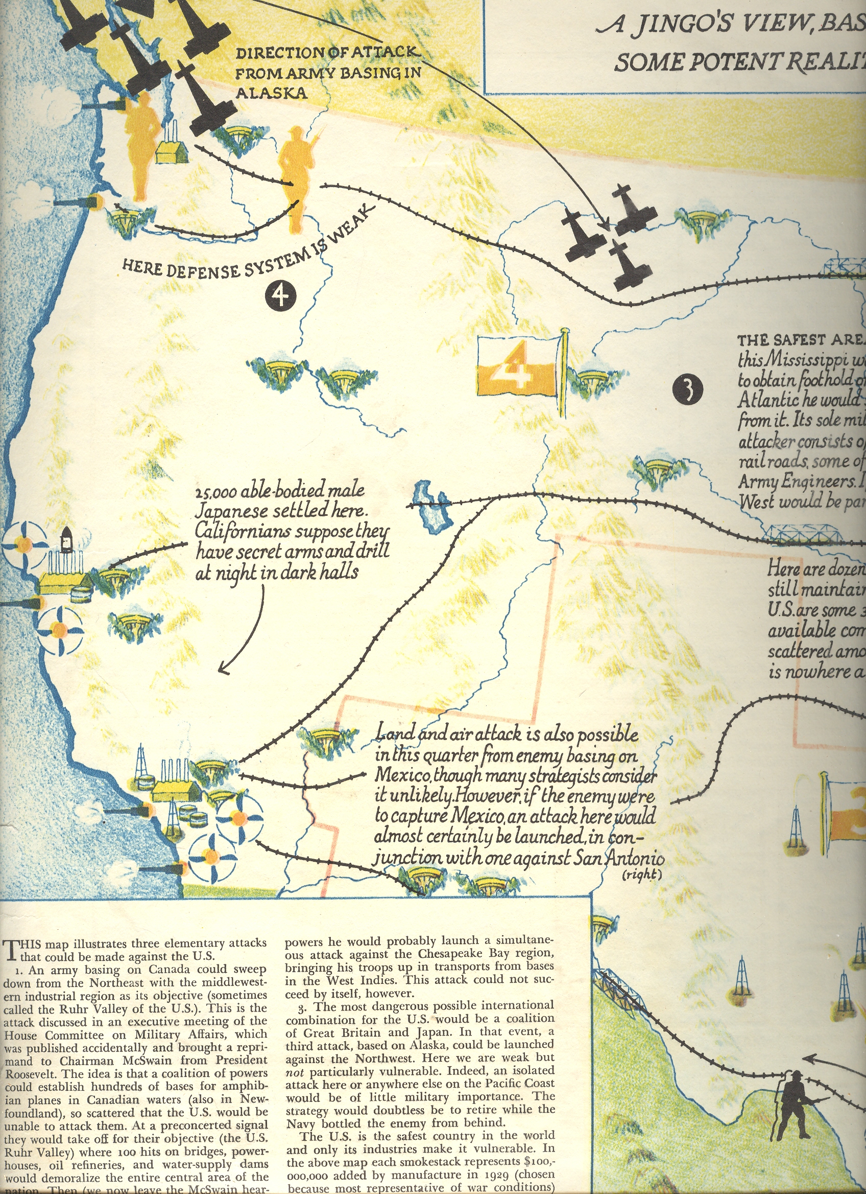
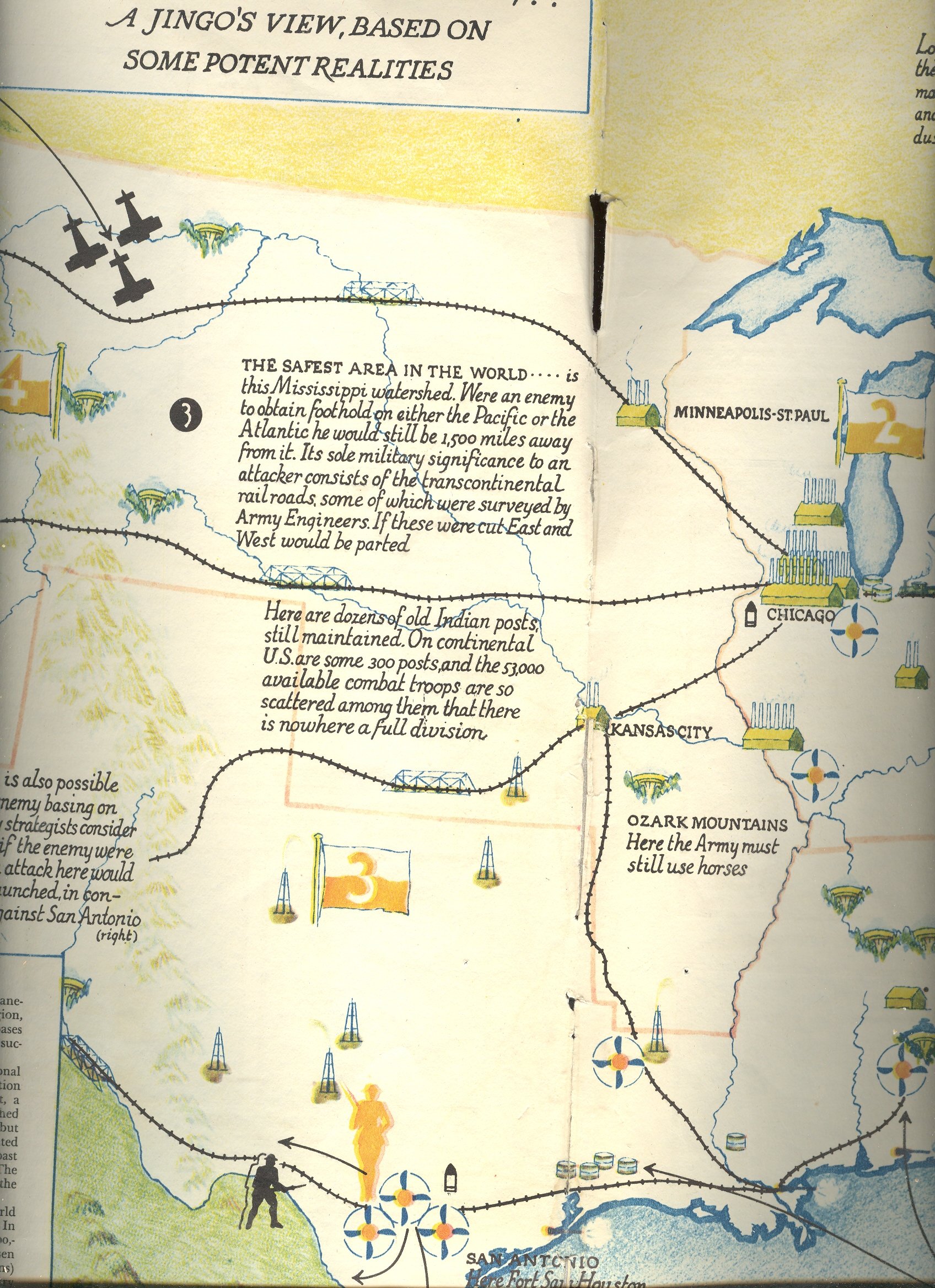
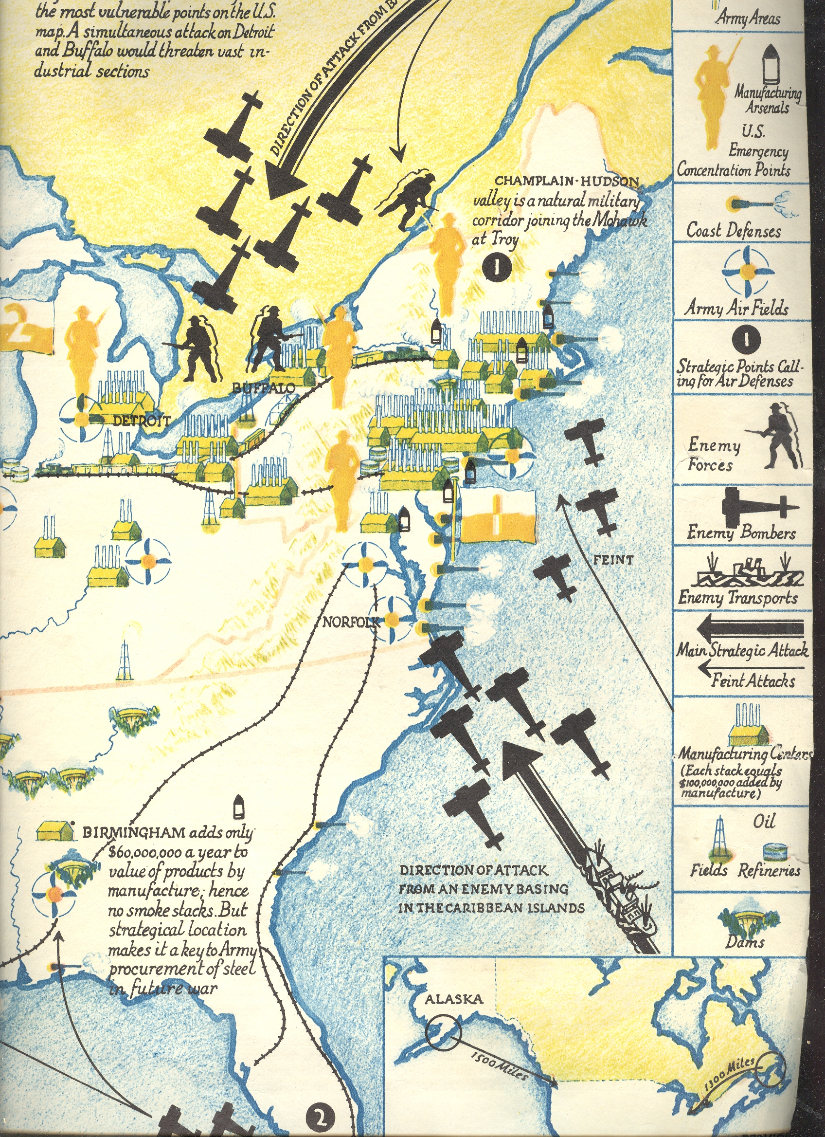
    Perhaps this non-invaded bit explains why the most-viewed post on this blog (with at last count was 400,000 views) was a LIFE magazine article from 1942 on the possible invasion routes to the U.S.  Maybe the volume was driven by war-gamers, though I suspect it was made up largely of the curious who weren’t used to seeing “Invasion of” and “America” together in a military sense.

    https://historyofideasblog.com/a/6a00d83542d51e69e20120a7a3225e970b-pi

    https://historyofideasblog.com/a/6a00d83542d51e69e2012876a5a4b4970c-pi

    https://historyofideasblog.com/a/6a00d83542d51e69e2012876a5a5e4970c-pi

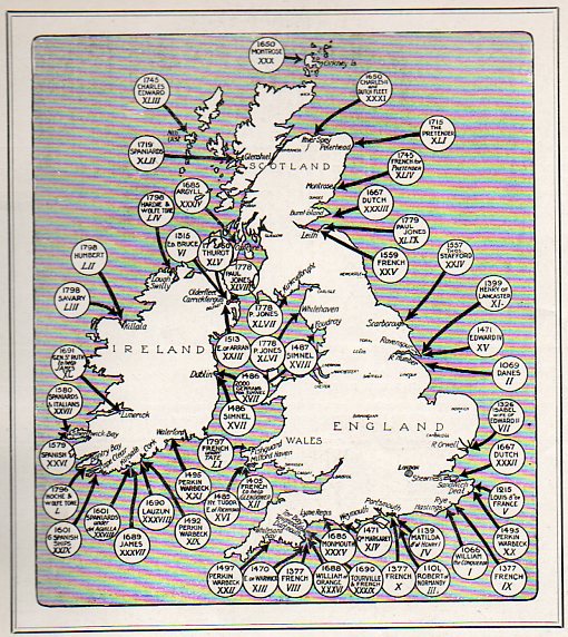
    But now for the  real stuff:  a map of the 54 invasions of Great Britain (and “the places at which foreign troops have landed on British soil since 1066 (and all that), seen in the Illustrated London News for 27 March 1909):

    Invasion--Us and England120

    And then this, where the WWII invasion routes were turned around: 

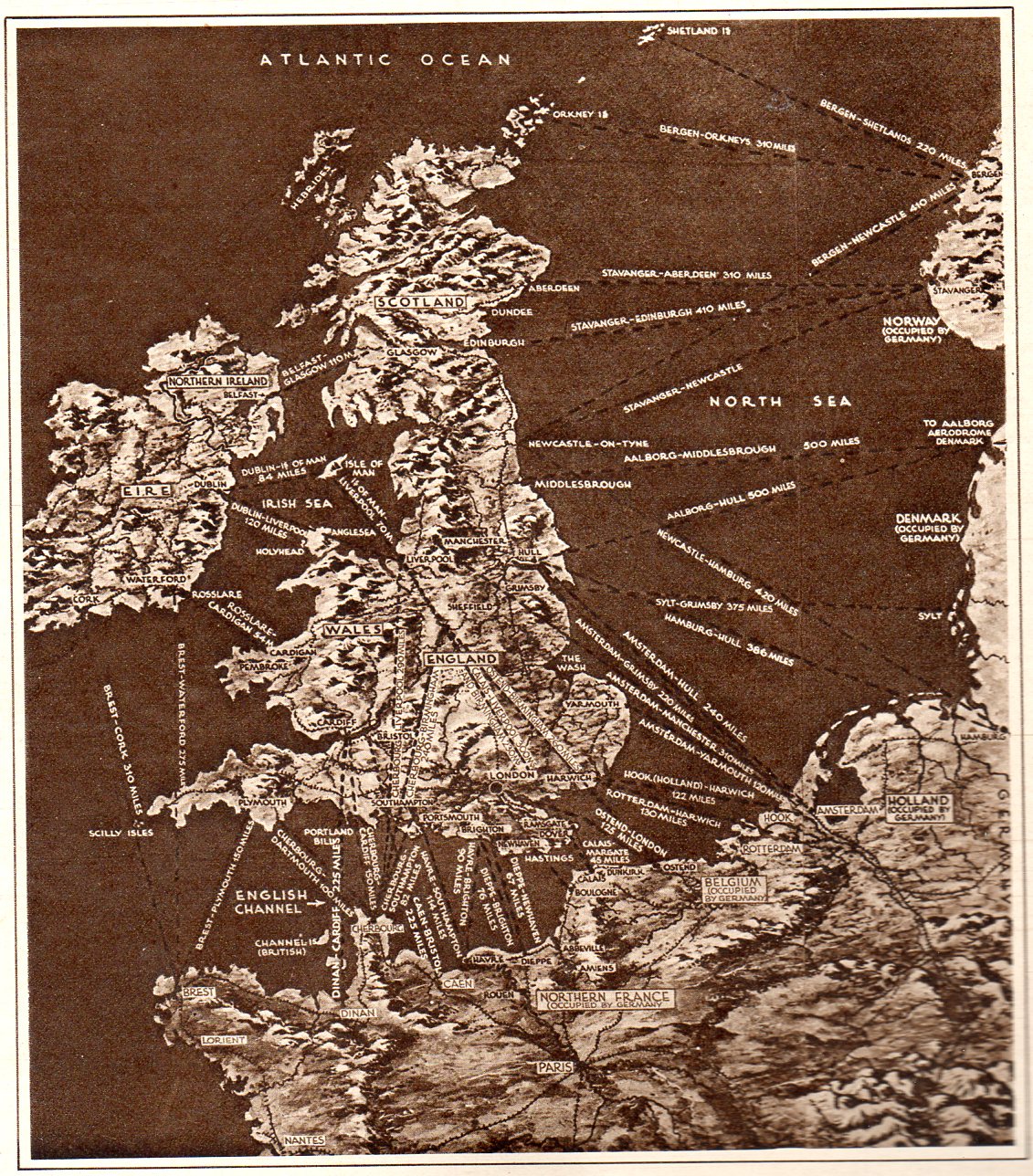
    Dunkerque124

    This map pretty well tells the story of the perilous situation of Europe and England at the beginning of June, 1940.  It appeared in the Illustrated London News on the heals of Churchill’s “Blood, Soil, Sweat and Tears” speech, and was a very frank presentation of the wearing of the war.  By this point in the war Nazi Germany had successfully invaded Belgium, France, Luxembourg and the Netherlands, sweeping across Europe in a broad westward movement, backing up British and French troops all the way to the sea at Dunkerque, where a monumental rescue operation (“Operation Dynamo”) saved them.  (There was an enormous amount of materiel left there on the beach, a devastating loss for the British Expeditionary Force, nearly crippling it.) This was a bad time for the Allies, this part of the war coined by Winston Churchill in 18 June 1940 in the House of Commons by:  “The Battle of France is over. I expect the Battle of Britain is about to begin”. There was very little good that came of these few months for the U.K and the Allies, though four things do stand out: (1) as I just mentioned, the saving of 300,000+ troops at Dunkerque; (2) the resignation of Neville Chamberlain, (3) the coming of Winston Churchill  as Prime Minister of the U.K., and (4) the first deciphering of the Enigma at Bletchley.  Other than that, the situation was dim, and these invasion routes (published at t he very time that Germany was studying such a feat in its “Operation Sea Lion“, or “Unternehmen Seelöwe”). The endgame at Dunkerque took place almost four years to the day of the invasion of Europe, when the intent (though not placement) all of these arrows were turned around for the Allied operation at the Normandy beaches on 6 June 1944..

    And so, there it is–a presentation of several maps showing invasions, real and imagined 


  • Reporting the Hiroshima Bomb the Day After, 7 August 1945. AND the First Graphic of NYC A-Bombed

    JF Ptak Science Books   Blog Bookstore  Post 1257 (continuing post 669)    Atomic and Nuclear Weapons Series

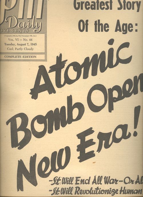
    ==Blog July 26=PM cvr bomb

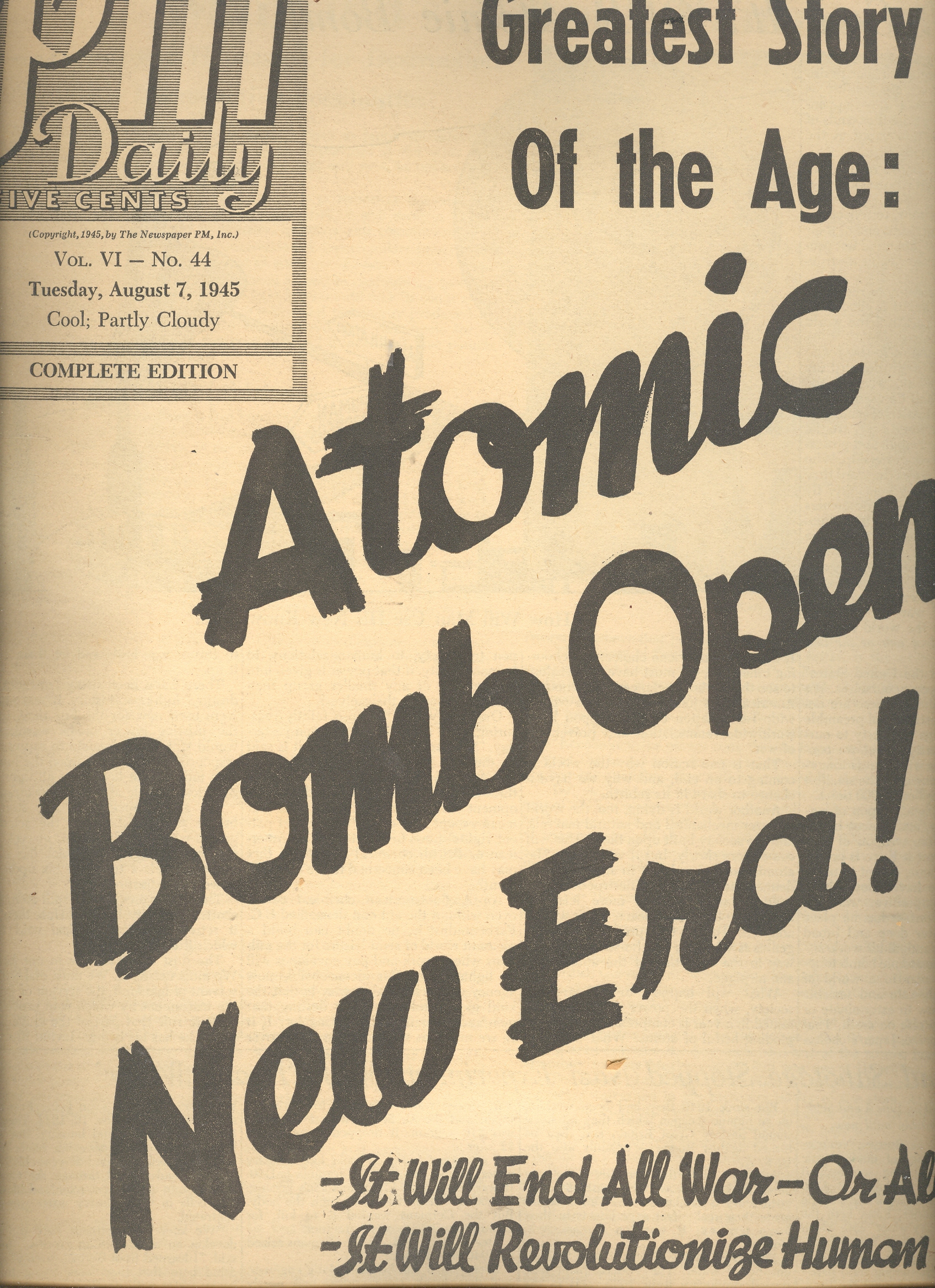
    The news coverage of the 6 August 1945 bombing of Hiroshima was covered in spectacular (all things and time considered) detail in the 7 August issue of the daily newspaper, PM.1  The entire issue of 12 pages (with no advertising2) was dedicated to the event—I have no idea, really, how they were able to put together this amount of good tough data so very quickly, nimbly and intelligently, as the bomb was detonated at Hiroshima only the day before. 

    It is odd how well the case is covered, and it is positively issued on the day after –it isn’t the case that it was issued for the week of 7 August and released on 13 August, which I thought was a possibility of explaining the deep coverage.  But there’s no mention of Nagasaki (which would come in two days), so I am certain that the coverage was all accomplished within 24 hours of the use of the weapon.  The newspaper distinguishes itself by not screaming something about the “Jap city” being wiped out (as so many other newspapers did), with its front page summarizing beyond the bomb.  (“It Will End all War—Or all Men” and “It Will Revolutionize Human Life” as sub-heads; the first being accurate, while the second being nearly so.) 

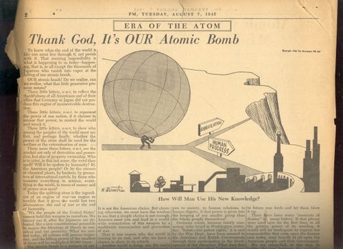
    The editorial, “Thank God its OUR Bomb”, by Irving Brant, is a lovely piece of thoughtful interpretation in the opening moments of the nuclear age. He writes: “America must join and lead in a worldwide renunciation of this worldwide renunciation and prevention of war”,and “What will happen to industry, to society, when the power of all the coal mined in a year is compressed into an exploding fistful of atoms?” And further:“There is no escape.  The split atom may shatter humanity, but not before then will it retreat into the physical void from which it came.  The dust of creation is in our hands.  We must master it.” Not bad stuff for having a few hours or so to think this  through. 


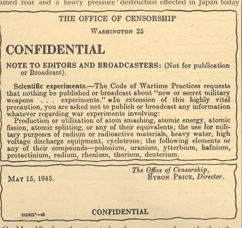
    ==Blog July 26=PM cvr bomb censor


    The other articles included “Bombs and Sabotage Stopped Nazi Experiment with Heavy Water”, “New Atomic Era Could Revolutionize Mankind’s Whole Manner of Life/Power Harnessed for Destruction Has Limitless Constructive Possibilities”, big two-page story “Stimson Reveals How Work on Bomb Was Organized”, “Bomb’s Death Range Believed to be 4 Miles”, “Four Scientists who Will Plan Postwar Uses of Atomic Energy”, “Harnessing of Atomic Power research Strengthens US Research”, “If a Piece of the Sun Were Placed on Earth”, “End Not Yet Truman Tells the Japanese”, and another 12 articles.

     ==Blog July 26=PM cvr bomb artoon

    There’s another baffling article “Steel Tower Vaporized in First Test”, discussing the shot at Alamagordo—it must have been the case that there was an enormous amount of material divulged by the government in the hours after the explosion at Hiroshima .  The work at Columbia is also chronicled, as is the personal life of the man in control, General Leslie Grove (and how completely in the dark his wife was, and so on). 

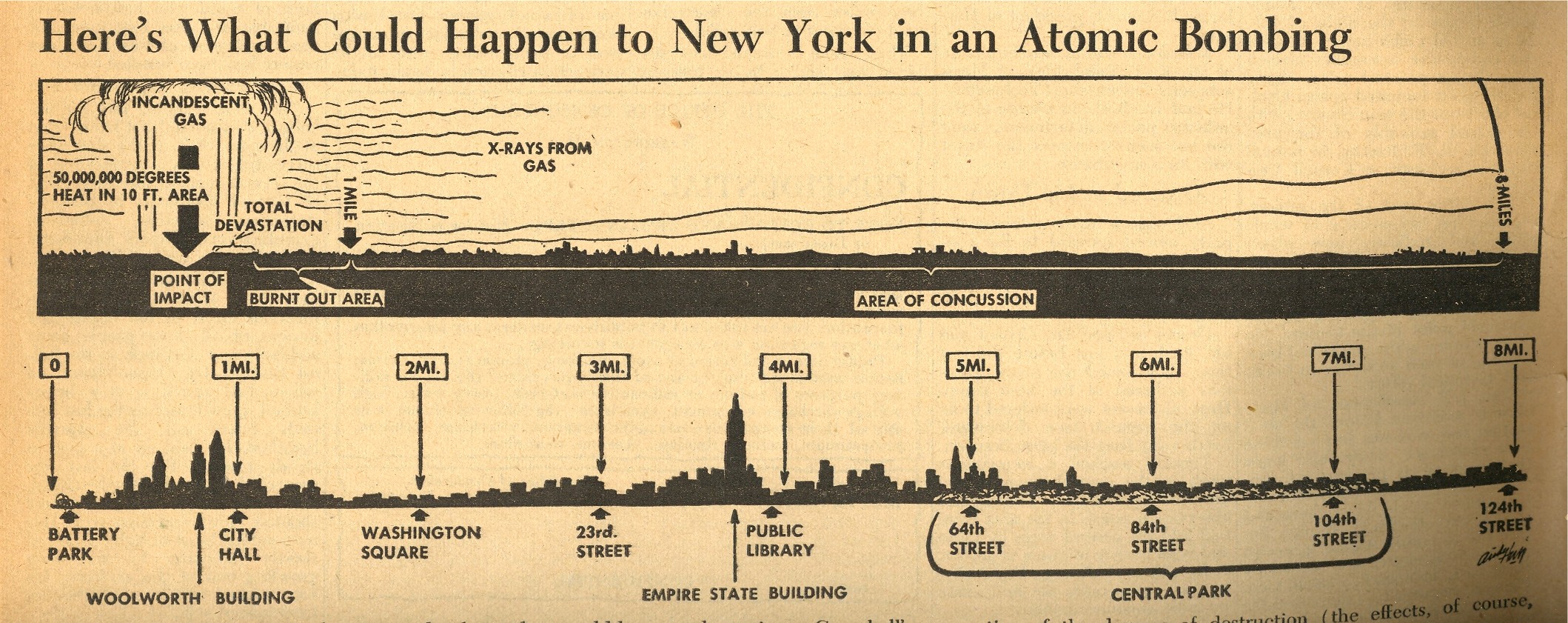
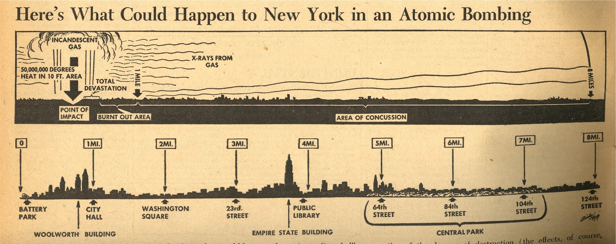
    One of the most interesting objects to me though is the small graphic on page 7 which shows what effect the Hiroshima atomic bomb would have if dropped on New York City—it was no doubt gigantically sobering to anyone who looked at it, and brought the power of the bomb and its destruction to a common, understandable point.  I’m not an historian of the first newspaper coverage of the bomb, but it strikes me that this may well be the first graphic to depict the effects of an atomic bomb exploded over NYC.

    ==Blog July 26=PM cvr bomb map
     

    In any event, the overall coverage of the event was stunning given the short amount of time to do the research, writing, and publication.  Truly a great effort. 

    Notes:

    1. PM (1940-1948) was a left-wing newspaper funded by Marshall Field III, and was home to excellent reporting.  See here for more details. Among the staff writers was I.F.Stone and staff photographers Margaret Bourke-White.  Other contributors included Heywood Hale Broun; James Thurber; (the great) Dorothy Parker; Ernest Hemingway; Eugene Lyons; Ben Stolberg; Malcolm Cowley; Tip O’Neill;and Ben Hecht.

    2. Actually, NO issue of PM had advertisements–it was entirely ad-free. (And even so it still came close to making money after 8 years.)

    PM‘s stated mission:

    PM is against people who push other people around.   PM accepts no advertising. PM belongs to no political party. PM is absolutely free and uncensored. PM’s sole source of income is its readers–to whom it alone is responsible.PM us one newspaper thayt can and dares to tell the truth.

    Theodore Geisel (Dr. Seuss) was a cartoonist for PM (see here for his War cartoons) as was the great Crockett Johnson.


  • Motion and Change in Natural Sculpture–the Galileos of Clouds and Snowflakes

    JF Ptak Ptak Science Books   Post 1235

    Blogcloud_howard It is odd to think among the great classifiers of nature, including even the lofty-namer Aristotle, that clouds were not scientifically classified until the early 19th century.   Here they are, just about the biggest thing we have as earthlings that are gigantic and close to us, and nobody offered a good classifications scheme until 200-odd years ago—a pretty slim margin of time  in the terms of recorded human history. 
    Clouds are of course problematic, what with floating around and all—but if you didn’t already know the relative newness of their recognizable names isn’t it shocking to learn this bit of history? For the most part I think clouds must have been thought as being too transient, changeable, whimsical, wispy, to be given proper names.   The great scientist and classifier Lamarck tried to do so in his  Annuaire Méteorologique of 1802, and really is the first to try this, but his ideas weren’t terribly good (especially compared to the rest of his work), and it seems as though he left his best thinking effort on clouds at home.  For example, he gave us Hazy, dappled, massed, broom-like and grouped clouds as classifications (in French, respectively, en forme de voile, pommelés, attroupés,  en balayeurs and groupés).  They seem quite “French” to me, but largely outside the scope of being useful. 

    It was the English pharmacist and chemist Luke Howard who in 1803 gave a greater bit of thought to structuring cloud names, classifying them according to size and shape and giving them Latin names—and this forms the basis of our naming clouds to this day.  Howard was perhaps the first, greatest, meteorologist, producing On the Modification of Clouds, (in which he describes his naming system, the “modification” part actually meaning classifying rather than changing),  The Climate of London, and the first textbook on weather,  Seven Lectures on Meteorology.  Howard’s system was expanded in 1887 by Abercromby and Hildebrandsson, who further classified clouds by height above ground as well as by appearance (and utilizing Howard’s naming system). 

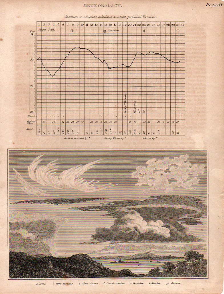
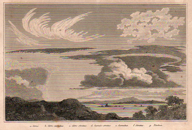
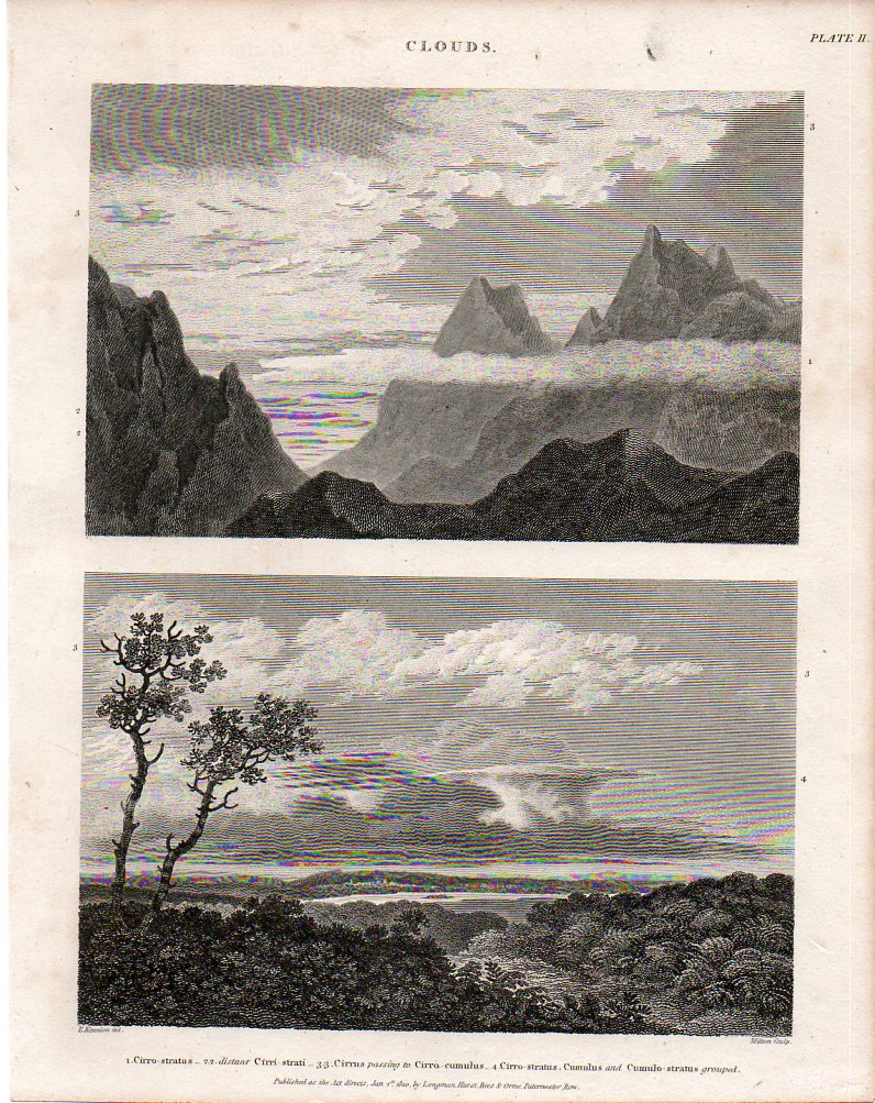
    Here (below) are two fine, early examples of cloud-naming for the scientifically-minded of the British elite, finding their way into print in the fabulous, ingenious and  mammoth (45-volume) Cyclopædia, or The New Cyclopaedia, or, Universal Dictionary of the Arts and Sciences, edited by Abraham Rees (1743-1825).  The work was published between 1802 and 1820, and was the resulting effort of 100 contributors who generally wrote monograph-length entries, contributing to a final tally of close to 40 million words.  I’ve particularly enjoyed the illustrations like those below—some of which have become iconic—and especially the fine and deep engraving of Wilson Lowry.

    {Both of these images below are available for purchase from our blog bookstore, here.]

    Clouds875

    Cloudsb876Howard began his system by identifying three basic shapes to clouds: heaps, layers, and curls.  Heaps of separated cloud  masses with flat bottoms and bulbous, splayed, tops, which he called cumulus, which is Latin for heap; the Latin stratus was applied to clouds in layers which were much wider than they were thick; and again to Latin for cirrus, which called out the wispy curls of clouds.  (Rain clouds were given the Latin nimbus, for rain, and so on.) 

      Cloudsbdet877

    It is interesting and romantic to think of Howard being moved in his love of clouds as many Brits and Europeans were in the Volcanic Year of 1783 by the enormous eruptions of the Eldeyjar (Iceland) and Asama Yama (Japan) volcanoes—the force of their eruptions caused enormous changes in the skies (especially in Europe), creating vast sky-borne tapestries (the “Great Fogg” in England) and for such extended periods of time that it would have beenBlogsnowflake_hooke impossible for the scientifically-minded Howard not to see them. 
    Blogsnowflake_bentley

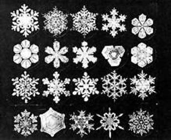
    Similar, in a way, to clouds is the snow crystal (snowflake)—they change forms in their lives from sky to ground, and may well disappear on contact with a warm surface.  Of course unlike clouds they may fall and be captured, kept even, though the ability to actually perform some sort of scientific something with them didn’t occur until 400 years ago, which means that snowflakes passed in and out of human existence being very simply named (in most languages) as a mass group, and not classified at all.

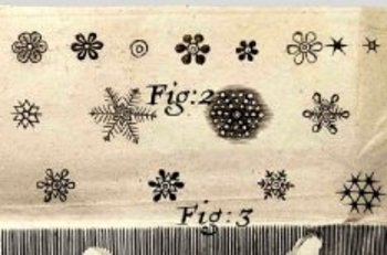
    Johannes Kepler thought very deeply in In 1611 publishing a short treatise called On the Six-Cornered Snowflake, thinking that perhaps their (mistaken) six-cornered symmetry revealed something much deeper about the basis of nature and the universe. The 26-year-old  Robert Hooke seems to be recognized as the first to throw the snowflake under a microscope, publishing drawings of them and just about everything else that he saw in his monumental (and tall, being 13-inches tall) Micrographia (1665)–the first truly scientific book of modern times.  The largest of the large images was saved for the flea, showing the unsuspecting public the great and beautiful nature of what seemed like a fantastical beast (under magnification).  Snowflakes appeared in the book, revealed in their intricate and seemingly-symmetrical nature.  Fantastic, unimagined images. This aside, he seems to have, um, borrowed these images from an earlier work, Thomas Bartholin’s  De Nivus usu Medico Observationes Varieae, 1661.  But so it goes. 
     

    The Galileo of the snowflake was Wilson Bentley (1865-1931), an autodidact Vermont farmer, seen by fellow hamlet-dwellers as odd and off, who figured out how to photographically and beautifully record the intricacies of the snow crystal world—no one had ever done this so dramatically, with such gorgeous results.  It really was as though he was able to record the heights of the mountains of the moon with a slender telescope in Pisa, 350 years earlier. The results of his decades of experience were published  in 1931 his book Snow Crystals, containing more than 2400 snow crystal images.  On the heals of Bentley’s accomplishments came the classically trained nuclear physicist Ukichiro Nakaya, who was truly the first person to apply a scientific classification to snowflakes, and who published his intrepidly-beautiful work in a 1954 book entitled Snow Crystals: Natural and Artificial.  His classification system of the various types of snowflakes would prove vastly more useful, interesting and appealing than that published by the 1951 the International Commission on Snow and Ice, and forms the basis of the discussion of snow crystals today—a classification system of a massively-occurring phenomenon that is younger than me. 


  • Nazi Propaganda–the Big Lie and Germany Surrounded, 1933

    JF Ptak Science Books  1174

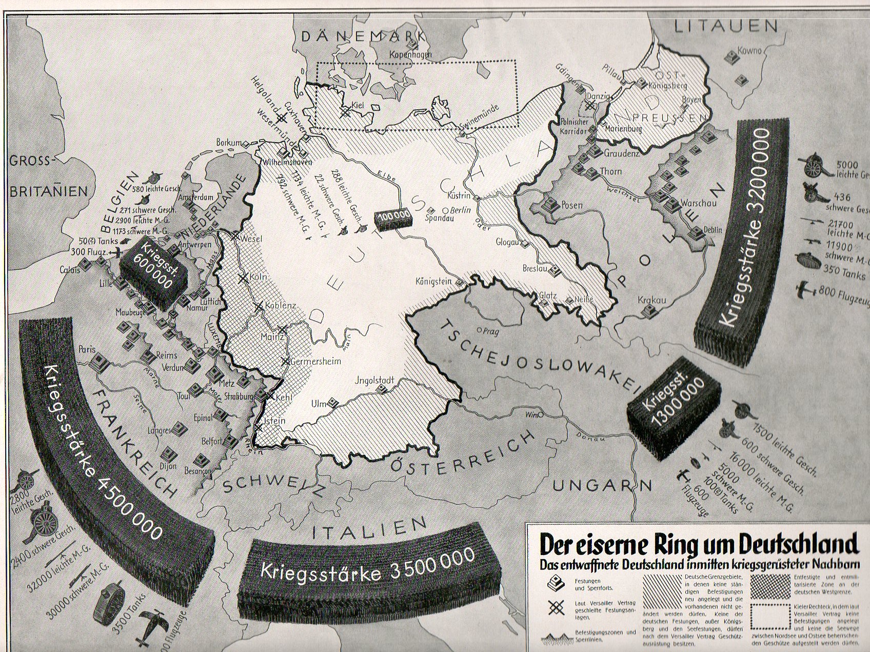
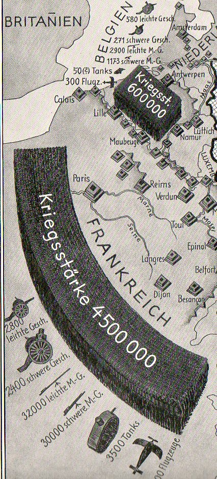
    The newly-elected NSDAP government lost little time in putting forward a case to the German people that the Treaty of Versailles left Germany in a defenceless postion, surrounded by forboding armies and air foprces of its neighbors, the forces of France, Italy, Czecholovakia, Belgium and Poland forging a tight and formidible strangelhold on the weakened Germany.  This image comes from the late November 1933 issue of the Illustrite Zeitung1 (Leipzig), and its relates to the casual and general reader the de-militarized and tenuous situation of the country–its design is effective enough so that the voice of he illustrations is well heard even if no on actually bothered to stop and read its legend–it was all about threat and impending doom, and the words for those emoptions weren’t necessary in this artwork.

    Nazi Prop surrounded538

    Campaigns like this were a first step in the Nazi consolidation of the public spirit, attempting to unify the population under Hitler and the NSDAP by presenting a threat so common that it could not help but to draw everyone into the big tent.  This was a simple message of natural survival, a wide threat to the German state, a threat that was so simple and so devastating and so opaque that there would be virtually no resistence to unifying against it. (J.W. WHeeler-Bennet wrote about this in his superb and still-classic book The Nemesis of Power, the Germany Army in Politics, 1918-1945, published in 1954.)

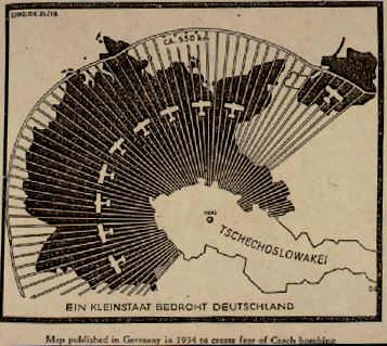
    Here’s another example from about the same time, again showing the devastating effects of imagery–this displays the non-existent threat from Czechoslovakia:

    Blog jan 3 czech air


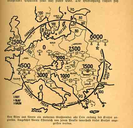
    And another, showing the encircling imagery again:

    https://historyofideasblog.com/a/6a00d83542d51e69e20120a7a04f7a970b-pi

    Getting back to the first image–curiously Great Britain and Russia don’t make the Enelmies Liest here, though in 1933 they certainly loomed as an enemy as much as any other.  (Well, perhaps not neessarily so for the Soivet Union, but close.)

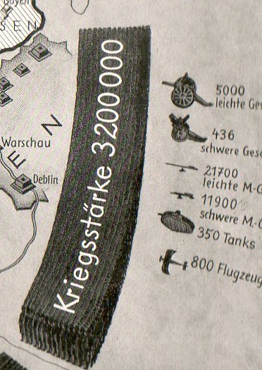
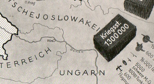
    Someone who actually read the article and looked closer at the full-page ilustration would see the details of t he European threat, like this for France (and Belgium), with bloated figures for WWI-era ordnance and an extremely effectively articiulated represntation of what was seen as the standing army:

    Nazi Prop surrounded france539

    And this for Poland:

    Nazi Prop surrounded poland542

    And of course, Czechoslovakia: Nazi Prop surrounded czech541

    Among other things the signing of the Treaty of Versailles in 1919 limited the German armed forces to less than 100,000; limited the Navy to 15,000; prohibited the manufacture of submarines, armed aircraft, tanks, armored cars, Maxim guns and of course poison gas. There was assignment of guilt, heavy reparations (in what today would translate into something like a half-trillion dollars, without though translating buying power), and much more that was aimed at keeping Germany vanquished if not somewhat pastoral.  Many have seen the Treaty as being the bridge and greatest impetus to WWII, an opportunity lost and squandered by the Allies–maybe so. A year after the end of the incredibly violent and ripping four-year onslaught in which millions were killed and so much destroyed it would’ve been difficult for all parties to the Treaty to have a great forward vision in how to best deal with Germany.

    The Treay did provide a unifying front for Hitler; the Nazi Party using choice aspects of it in hearts-and-minds propagandizing methods like the one above:  the military restrictions were true, but the portrayed threat of attack from Poland and Czechoslovkia and Belgium and Italy and even France were part of the building of the Big Lie.  The “Big Lie” was something that Hitler identified in his 1925 Mein Kampf, and then used in his own terror campaigns–it is a lie so colossal and so impudent, so fantastic, that it is perceived as being true because no one would lie so gigantically.  As  George Orwell put it in his 1948 novel 1984, the Big Lie was “…to tell deliberate lies while genuinely believing in them, to forget any fact that has become inconvenient, and then when it becomes necessary again, to draw it back from oblivion for just so long as it is needed….”  The perception of imminent threat was one of the starting points for the Big Lie; the mechanics and people behind the manufacture of the invasion, of the Treaty of Versailles, of the German economic meltdown, and so on was already laid down in Hitler’s ridciulous book, and much of that lay at the feet of the Jewish people. 

    But first the Nazis needed to address the issue of their entirely weak and vulnerable military position by proposing the threat from much of the rest of Europe, this in order to rail against Versailles and break the German obligations to non-militarism.  The foundations for rebuilding the German war machine started in earnest in 1933; by 1935 most of the restrictions of Versailles had been broken, and Germany (which in 1933/4 had bene secretive about it) had gone public with its new obligations to itself (introducing the Luftwaffe to the rest of the world in March1935).  Reactions from the Allies to generating the new war machine were weak, and Germany rolled right into WWII. 

    Notes:

    1. I’ve written many times here about the Illustrirte Zeitung–it was basically the German equivalent of the Illustrated London News, Paris Match, and LIFE magazine, a better, mid-level weekly magazine that was well-written, very-well illustrated, approachable and affordable to folks of nearly all classes.  It was an expedient way of sending across the government’s message from te beginning of the Nazi ouccpation of German politics.


  • Thinking Deep about St. Paul’s and the Eiffel Tower–Presenting the Depths of the Oceans in Plaster and Steel,1910

    JF Ptak Science Books   Post 1173

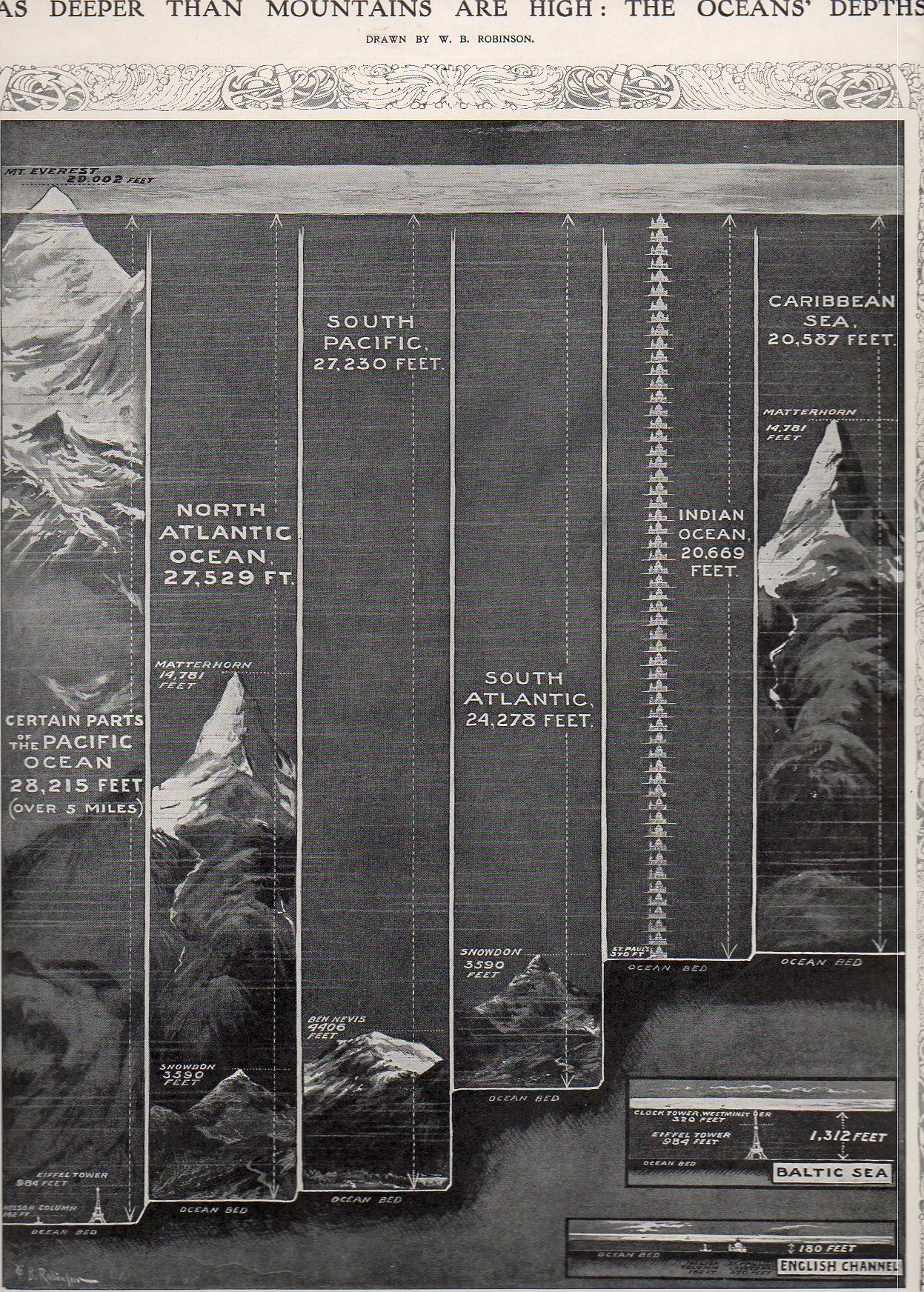
    Although maps showing the depths of the oceans existed from about the mid-19th century (through the pioneering work of the American father of oceanography, Virginia’s Matthew Fontaine Maury1) few casual readers would have ever seen a more approachable representation of information than what appeared in the Illustrated London News for 8 October 1910. Although Maury’s maps are elegant, they didn’t receive nearly as wide a distribution as this ILN image–also they weren’t nearly quite as relational as the 1910 version.

    Sea depths533

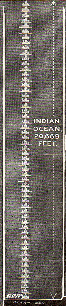
    Granted, the 1910 comparison chart only displays one statistic–the supposed greatest dept of five oceans, two seas and the English channel–it does so in such a way as to make those numbers immediately approachable to any reader, which is always an issue in relating scientific information to the general reader.

    Sea depths ist pauls537 {One of the standard unit of measurement for the purpose of this display was St. Paul’s Cathedral.]


     What W.B. Robinson presented was a way of looking at an invisible entity through very visible means–comparing depth to the heights of things that everybody in 1910 knew: the Eiffel Tower (relatively newly constructed out of 18,000 prefabricated highly-engineered pieces) and St. Paul’s Cathedral. So rather than stating that the Pacific Ocean is 28,000 feet deep, Robinson chose to replace feet with Nelson’s Column–174 of them. Or 29 Eiffel Towers. The 20,000-foot deep Indian Ocean was actually 56 St. Paul’s deep, while the Baltic Sea was deep enough to not quite cover one Eiffel Tower with one Westminster Bell Tower on top (ha!); and the English Channel at its deepest wouldn’t quite cover St. Paul’s.

    This is really the way to display data in my book, especially to kids.  This is one of the few ways of making the information accessible and understandable across almost all age ranges. 

    Notes:
    1.  Actually the work goes back a century before Maury with Buache, who produced this map of the English Channel in 1737–the data points are veyr numerous, but this is the very first time that such information was available on a map.

    Sea depths idouth pacific536 Sea depths indian535


    NOAA Photo Library Image - map00004

    And Maury again with this first map of an oceanic basin, published in 1853:

    NOAA Photo Library Image - map00001

     And in 1752, Philippe Buache produced this fantastic and first-of-its-kind map for the depths of the English Channel:

    NOAA Photo Library Image - map00186

    Here’s an extraordinary cross sectrion of a part of the ocean floor produced in 1857 by the HMS Cyclops in preparation for laying the Atlantic Cable:

    NOAA Photo Library Image - map00010


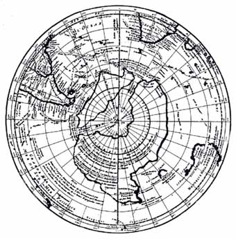
    Its also interesting to note here Buache’s work on this map of Antarctica, published in 1737.  Buache put together all of the known (to him) information about the mass in the South, bits taken from other maps, and accumulated them into what was the best-possible guess on what was down there in the Antiopode.  Pretty good detective work given the amount of material that he could work with.


  • A Note on American Two-Way Border Wars

    JF Ptak Science Books  Post 1171

    Porosity  is a measure of spaces-in-between, voids in a material’s total volume.  Some things certainly have visible porous elements, like a cotton shirt or netting, and others–like rocks and soil–don’t.  Other elements are measurable but less visible and experimental than fluid flow though still experiential,  like truth and falsity, or the concepts of good and evil, good taste and bad, love, generosity, felicity.  Ideas like “god” are very porous, as are the prospects of salvation and redemption, and (getting into) heaven and hell. 
                               
    Skin is also porous because it is composed of, well, pores. We don’t think of things like skin being permeable, as it holds in the vast amounts of liquids that make up the majority of the human body (for example).  Football has porous defenses, a necessary design to the process of the game, because years of 0-0 games just won’t work so well as paid entertainment.  Poromechanics in real and abstract bits is all a matter of degree.  And direction.         
    http://blog.selfportrait.net/blog/wp-content/uploads/2010/07/frances-flora-palmer-for-currier-and-ives-across-the-continent-westward-the-course-of-empire-makes-its-way-1868.jpg
    The American border is fairly well porous–much less now than it used to be of course.  There’s 3,987 miles of border (excluding Alaska) with Canada, and another 1969 miles between the U.S. and Mexico (1241 of those shared with Texas), so there’s a lot of room for room–for people trying to get into the country.  The flow of people through/over the borders weren’t always gong one-way–the expansion of the country is a history of the mythic pioneer/settler moving into space contiguous  to property that was owned by the U.S.  (Actually, it wasn’t all contiguous, adventurers and “explorers and entrepreneurs and filibusterers reaching far and wide.)  It would be interesting to know how many miles of variable borders within the U.S. we have slipped through over the last few centuries–my offhand guess is that it is an order of magnitude greater than what we have right now.

    Before we constructed massive walls and armed our borders, before we started to erase the incised sentiments on the base of the Statue of Liberty, the border wars of the United States were being fought going the other way ‘round.  The borders of the country were extended in many different ways, not the least of which were what we would call “pioneers”–plus of course politicians and the military, all deeply at work in establishiung the sactions of expansion.

    For example, in the 1800-1850 period, there were 21 major attempts to access foreign properties to become part of the United States.  Ten of these were attempts made to purchase the land outright–only Louisiana (and that is a gigantic “only” was wholly successful, with Sonoma being half-successful.  Five of  the other cases– East Florida, West Florida, Texas, New Mexico  and Alta California–came to us via wartime acquisition.  Attempts to buy and bully Mexico for Baja didn’t work; Yucatan and Cuba escape our proposals for annexation and purchase as well, while Chihuahua resisted purchase, invasion and annexation. 

    All of this excludes Indian lands, of course, a list of the tribes involved in the 709 seizures1 can be found in the continued reading section, below.  (That’s the number of “transactions” for the 110 year history between 1784 and 1894, which extends beyond the 1800-1850 slice of our expansionist pie; there were still a hundred or so motions against the Indians during this time, not to mention the dreadful Southern Removals of the Five Civilized Tribes as well as the disastrous removals in Indiana.)

    Conquest and purchase has been the name of the game in moving the Americans through our borders, an exercise of great regularity and incredibly high return.  Again putting aside the Indian question, had we not pushed up against the owners of these lands in the first place and absorbed them in the second, instead of having California, Utah and Texas we may well have had the Republics of California and Texas and the entity of Dereret, not to mention a wide swath of the southwest (including New Mexico, Nevada and part of Colorado) reaching up nearly to SLC that still belong to Mexico.

    And what it all boils down to after the borders have been passed through and moved forward, again, are the people that wind up staying–pioneers, farmers. The log cabin came to symbolize this spirit in the 19th century, a picture of progressive civilization and stability, of spirit, of achieving Manifest Destiny.  In my own collection of images of log cabins (prior to the Civil War), there are very few of these structures that show people in or near them.  More often than not, the pictures are silent; every now and then, there is a woman in the doorway or inside looking through a window–a symbol of innocense and felicity. There are images with the log cabin in the background, the foreground filled with pulled stumps and men plowing the fields (with and without horses) I don’t own a single image that shows a man with a gun.  (I’ve not done a survey on this issue, but that’s my overall impression over the years.) A subtle message I think was definitely being sent.
     
    Even the name “America” proved to be exceptionally porous.  At one point it stood to include North and South America, and then  it changed to exclude South and Central, and then Canada, and then Mexico–it really only related to the United States during the period of greatest nation building.

    This is just an interesting thing to think about now when we discuss closing our borders–those lines had to get to those positions somehow over the last 500-odd years.

    Notes:

    1. Indian Land Cessions in the United States,1784-1894, United States Serial Set, Number 4015; this is the  second part of the two-part Eighteenth Annual Report of the Bureau of American Ethnology to the Secretary of the Smithsonian Institution, 1896-1897.  “The Schedule of Indian Land Cessions subtitle notes that it indicates the number and location of each cession by or reservation for the Indian tribes from the organization of the Federal Government to and including 1894, together with descriptions of the tracts so ceded or reserved, the date of the treaty, law or executive order governing the same, the name of the tribe or tribes affected thereby, and historical data and references bearing thereon.”

    Sometimes just seeing hte extent of a list of names gives you a much greater appreciation for the numbers involvewd than the sheer number itself:
    Acoma Pueblo
    Alabama
    Alsea et al
    Apache
    Apache (Eastern bands)
    Apache (Jicarilla bands).
    Apache (southern).
    Apache (Southern).
    Apache (Western bands)


  • Nazi Propaganda to the French–Leave France Behind and Join Us

    JF Ptak Science Books   Post 1156
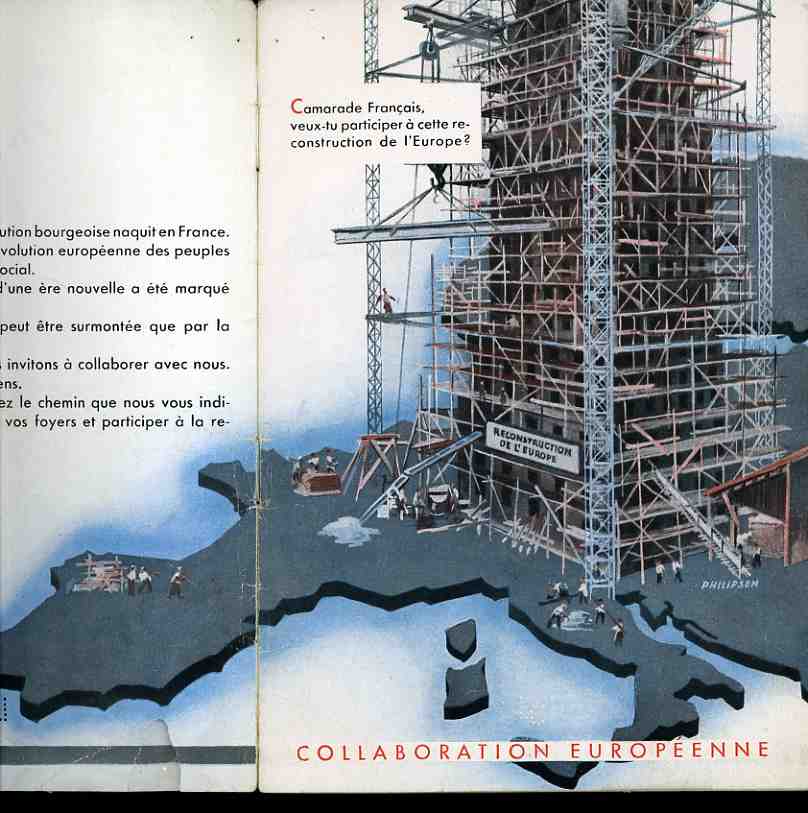
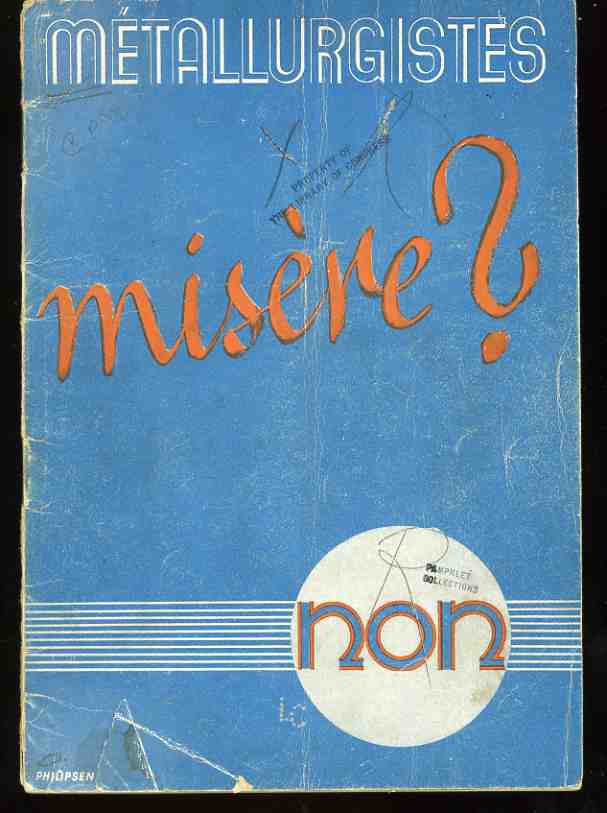
    0--blog-dec 9 vichy cvr220This appeal to practicing French metallurgists by the Nazi occupying force (Metallurgistes misere? Non 1943.) promised good wages, a clean place to sleep, and a livable future.  This included a life for professional metallurgists with a family, as well.  The Nazis were (blood) thirsty for practically-trained “help”, desperate for people with an expertise in occupied France to help contribute to their war effort, and this pamphlet was one means of trying to persuade (via propaganda) or purchase the tacit approval of these professionals.  The Nazis were promising a place to all of those who followed the call, a place in the resurrection of Europe, in the rebuilding of the European community under German/Nazi rule. 

    There was one very odd problem in this pamphlet.  The map shows the creation of this very large allegorical structure, which naturally centers on Germany;

    0--blog-dec 9 vichy cvr219

    but strangely enough, none of the structure seems to touch French
    soil–so much for the “New Europe”.  As a matter of fact it looks as though there is a table with
    three men standing around it at just about the exact place that Paris
    would be.  I’m not convinced that this was intentionally represented
    this way, showing the French reader that France was not going to be
    part of the rebirth–not having France as a part of this new empire
    would seem to be unthinkable–perhaps.  Maybe the issue was to show the inductees that should they decide to stay at home they and their family and the rest of the country will be part of a destitute agrarian Medieval future, that France would not be part of the New Europe, rather than someone screwing up in the Nazi propaganda offices. The screwup is possible though–they were, after all, only Nazis.

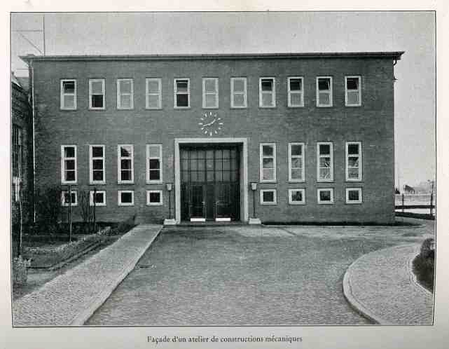
    Photos of the promised facilities:

    0--blog-dec 9 vichy clock222


  • Center of Attention–a Map of Women’s Visual Exploration of Men (1941)

    JF Ptak Science Books Post 1136

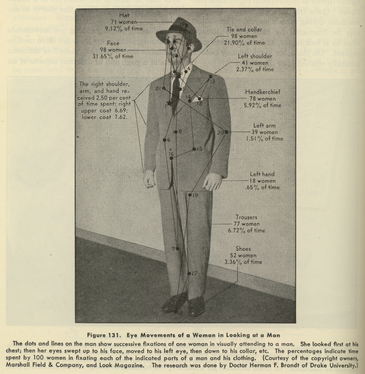
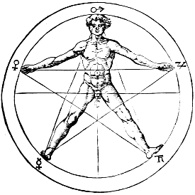
    The eye leads the brain, or the brain leads the eye, and from there, who knows where anything goes, especially when involved with a qualitative survey of a complex entity. This is more-or-less what we are dealing with here, in this image below, found on page 74 of a 1941 issue of Life magazine. (It is related in some way to an earlier post on this blog, a post called “The Center of Levity..”1 , though perhaps not really.)  It is hardly a map of the macrocosmos incised with Pythagorean precision on the body of man2, nor an astrological  or Kabalistic or Vitruvian perspective representation of humanity.  It is just a 1940’s  eye-trail map of where women looked at a man, a non-mathematical treatment of vague interest.

    Eye fixations

    It turns out that the seduction of a man’s body to a woman’s gaze–as difficult as that might seem from this photo–is fairly measurable, and was so even in the 1940’s, when the researcher Herman F. Brandt (Drake University, Iowa) produced this image.  And what it is, basically, is a map of where women looked when their eyes were tracked as they looked at this man.  Brandt had a long career investigating ocular fixation, and (I think) developed a camera that would track the reflection of beams of light on the corneas of his subjects, recording eye movement in horizontal and vertical planes, as they drank in this fine figure of manhood.  In any event his research was of interest to a wide variety of people, from neurologists to fashion designers–I’ve got no idea of how that interest was manifested, or if it turned out to be valuable information.  I do know that the Brandt work utilized by Marshall Field & Co. did produce a remarkable photograph open to all sorts of interpretation.   Visual stimulus point #19 was left uninterpreted and unmentioned, though the great majority of visual hits was above the waist, and above the neck.

    Notes:

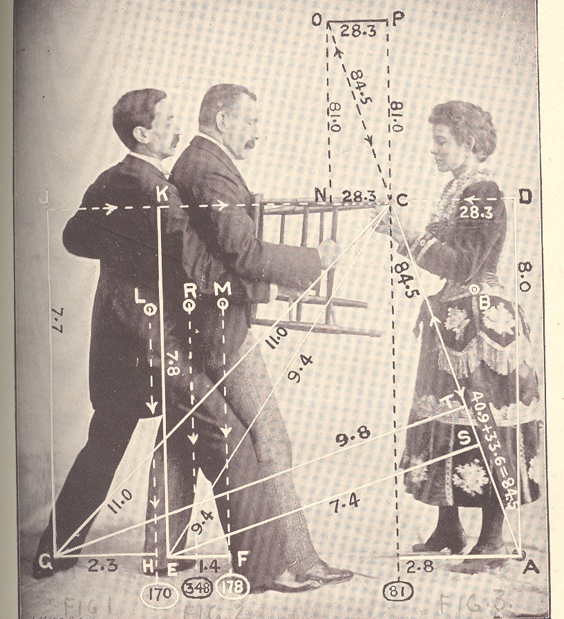
    1. One of the images from the Center of Levity post:

    Mar 23 center of levity cvr det 2

    2. For example, this classic from Agrippa von Nettesheim, De Occulta Philosophia (1533):

    Agrippa