A Daily History of Holes, Dots, Lines, Science, History, Math, Physics, Art, the Unintentional Absurd, Architecture, Maps, Data Visualization, Blank and Missing Things, and so on. |1.6 million words, 7500 images, 4.9 million hits| Press & appearances in The Times, Le Figaro, Mensa, The Economist, The Guardian, Discovery News, Slate, Le Monde, Sci American Blogs, Le Pont, and many other places… 5000+ total posts since 2008.

Category: Maps, Cartography, History of Mapmaking

  • Where is THE West? And: How to Find Nowhere.

    JF Ptak Science Books  Post 320

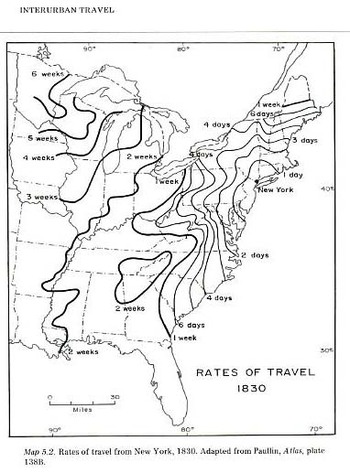
      This wonderful map is from Charles Paullin and John K. Wright Atlas of the Historical Geography of the United States, Washington, Carnegie Institution, and New York, American Geographical Society, 1932. It is just so very interesting and unusual–I’m not so sure that I’ve seen another map quite like this, illustrating travel time and difficulty..  One major stand-alone feature here for me is the distance from New York City to my own area of the U.S., the southern Appalachian region of western North Carolina: it took six days to get to Savannah from NYC and two weeks (!) to get up here in the mountains, which looks to be about the same amount of time it took to get to the Chicago area.  Of course once you got to Asheville in 1830 you were, well, probably looking to get somewhere else. I’d take it that the turkey population vastly outnumbered the people.  Maybe the horses did, too.  Getting back on track here though the West in the U.S. at the time began just on the other side of the state of Tennessee, and it wasn’t but a couple (?) of censuses before this that the West was right about at the Cumberland Gap/Ohio River basin region.
    File0844

    Perhaps this leads us to a more interesting if badly-asked question:  where does the American West begin? 

    This is an awfully tricky question, best left to the answer that pops into your mind the instant you hear the question, before the problems of what the sentence entails creep in.

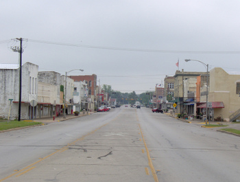
    Locating where the West begins is a curious, personal adventure–is it on the other side of the Mississippi, or does it really start in Texas, and once in Texas does it start in Austin or the sleepy Brazos? Does it really begin where the sign says it did, at Meacham Field in Fort Worth?
    Blogoctlast_piovcture

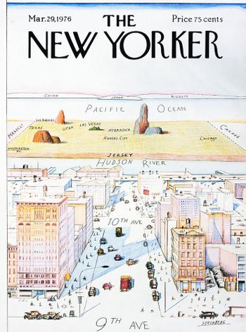
    It depends on the era, too, as we just said above; in the 18th century the American West was really out there with the makers of the martyr Bibles in Ephrata, which means that the rest of the  place was really very big.  And of course you can go all the way back to the beginning of European colonization here, all of North America was the West, at least to the people who were boarding the ships thousands of miles away across the Atlantic. And even once they got here the West was problematic–for the Spanish in the southlands there doesn’t really seem to be a “west”, only the northlands. In the 16th century the West was just creeping into Pennsylvania (Penn’s Forests), and the French and Indian War in the mid 18th century was fought over the control of “the West”, the crux of it all heading down to the forks of the Ohio at Pittsburgh.  Even in the late 18th century, the West was still not all that far away, relative to what we think of today, what with Kentucky being the first “Western” state admitted to the Union (in 1792).  It would probably be easiest just to say that the Mississippi River is the dividing line; after all, Lewis and Clark departed (in 1803) on their expedition from St. Louis (as did hundreds of thousands of other people later in the century who were seeking their new life in the West).  Then there’s the West of Saul Steinberg. who puts the whole thing on the other side of the Hudson…I’m not so sure if the West didn’t start for some people somewhere along 11th Ave.

    And where does the West “end”?  Does the West make it all the way to California coast, or does it stop in the desert, east of Sacramento?  Do people think of Oregon and Washington as the West; certainly they’re western, but are they The West?   To really complicate things, I guess you could define the middle of the West and look for the boundaries.  But the middle of the West usually seems to me to be flat and red and not terribly high; who’s to say that a nice town in Colorado (Salida?) might not be the middle of the West, even if it is 7,000 feet high?   
    Blogoct_18steinberg

    Its a tricky question and probably most people have a different answer for it.  For that matter, what about the South?  Where does that begin? I’m in a southernish state, but I hardly think of Asheville as being in The South per se. Maybe we’re too high; maybe the place over 2000′ in elevation that are south of Pennsylvania are just Appalachia, and actually not part of the South.  Scotland Neck over on the other part of my state is definitely the South to me, but perhaps it isn’t too much very Southern for someone in the high delta, or taking an easy afternoon in Oxford, Mississippi, or anywhere else in the Louisiana-Mississippi-Alabama-Georgia block.  I know that to Robert Johnson and Honeyboy Edwards and Son House and  Muddy Waters and anyone else in Coahoma county that the South didn’t go all that far north from where they were sitting. .In maps from sat 1850-1890 that area is called “the deep south”; seems to me that anytime you have a geographical location with a qualifying prefix, you’re actually dealing with the real thing, everyone else without the prefix being pretenders, or just something else. 

    Same too for the North–is everything above Washington D.C. northern?  I wouldn’t tell my father that, being a Berkshire Hills (MA) boy; but that’s another problem, especially to someone in Bangor.

    So somewhere in all of this, after figuring out where all of these places start, somewhere in  there is a place in this country that rejects these geographical delineations–that’s the place I’d like to find.  (When I was describing this idea yesterday to a friend, Renee, a Texan via way of Alabama–like many of the defenders of the Alamo–the answer came immediately:  “Kansas” she said.

    I’m not sure I agree.  But then once I get past my immediate response (Texas without Trees), I start to think of a 3-D representation, trying to accommodate time.  I don’t have answer for the place that isn’t anywhere, but once you start drawing enough circles to signify where The North South East West is/are, there is sure to be a little spot that gets overlapped by all of the circles more often than any other place–and that is where I think you’ll find Nowhere.



  • A Map of a Fortune in Frogs (1936)

    JF Ptak Science Books Post 263

    Blog1sept_16_frogs_detail555

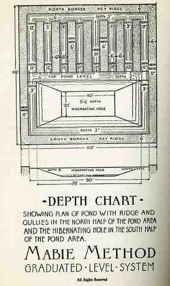
    This is the great promise of this remarkably mundane and contemporarily-wholly-removed pamphlet, which promises rewards and riches to be made in even the simplest backyard frog ranch, and all done with water, cement and no secret decoder ring. I mean, good night! I really had no idea whatsoever about such frog-goings-on in the depths of our country, even if the “depths” was Ridgewood, New Jersey, and it was the Depression (this pamphlet published in 1936).  I don’t have too much else to say about this remark effort except that–for all I know and I am not going to research it–this may well be the earliest Frog Ranch Plan published in the U.S.  There.  I said it (though my “key words” section says it all: “Frog farm, frog ranch, frog raising, frog map”).

    Blog1sept_16_frogs554_2

    Blog1sept_16_frogs_map556

    Blog1sept_16_frogs_contents557


  • Graphical Display of Data: the R.A.F. and Luftwaffe Present Their Cases, 1938-1940

    JF Ptak Science Books LLC  Post 262


    Blog1sept_15raf_range_1939551

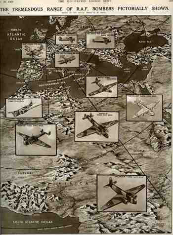
    These four images represent some common, popular distribution of
    information to the general population, the sets of two working at cross
    purposes.  (I’ve written several posts here about the Nazi use of maps as a propaganda tool; if you search this blog under those terms you’ll find several entries.)  The British images  were issued just after the start of WWII
    (30 September 1939) and then again just after the end of the Battle of
    Britain (November 1, 1941), respectively.  The first (“The Tremendous
    Range of RAF Bombers Pictorially Shown”), illustrates the range
    capacity of its long range bombers for WWI and for 1939, showing how
    far they could strike into the heart of Africa.  I’m not so sure why
    Africa was chosen as the target, as nothing at all was happening there,
    militarily speaking, at this early stage of the war; why this didn’t
    show the planes screaming their way to the east is a mystery to me.   
    The Home Office was busy showing how far the Wellington bomber could
    reach (3,240 mles), as well as the long shadows cast by the Hampden,
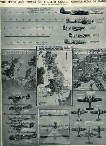
    Sunderland and Wellesley.  The second British image, “The Speed and
    Power of Fighter Craft, Comparisons of Range”  displays aircraft of the
    principle RAF and Luftwaffe fighters and bombers. 

    Blog1sept_16_aviation_maps_germany5

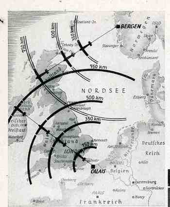
    The first German image, printed as a small inset map in a general propaganda piece in the Illustrirte Zeitung (Leipzg), for November 1940, depicted the capacity of the Luftwaffe to reach, threaten and bomb any region in the British Isles from bases in Calais (France) and Norway, having secured the positions in their attacks against the two countries in Fall Gelb and Operation Weserubung respectively. Britain was effectively half-surrounded from these positions from the Brittany to the Norwegian coasts.

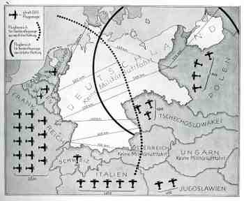
    The second German map (and the fourth presented here) is another interesting fiction coming from the propaganda offices in 1938, showing how Germany was threatened by attack from the air forces of its neighbors.  Particularly pungent in this portrayal was the threat from Checoslovakia, Yugoslavia and Poland.
      

    Blog1sept_15raf_range_1941552

    Blog1sept_16_aviation_maps_german_2


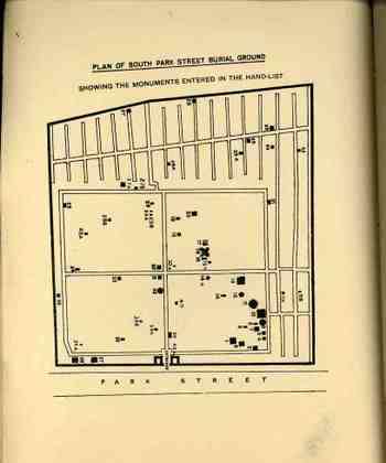
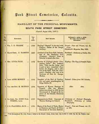
  • Imagined Neighborhoods of the Far-Away Dead: Park Street Cemetery, Calcutta

    JF Ptak Science Books LLC Post 257

    Blog1sept_13_calcutta547
    I wonder what this cemetery looks like now, this colonial funiery landscape, all these British occupiers buried in their imagined death community? (Lord Curzon, for one, found it to be “the most pathetic site in Calcutta”, which in 1900 was saying allot According to the piece below from the Telegraph, Calcutta, things haven’t gotten much better.)  Is there any melancholy left for a place like this, filled with the British working class in the heart of Calcutta?  Perhaps they could never have imagined their Further India slip away on its own, and that they’d be buried in a so-incredibly foreign land?

    Seems like this would be ripe terrain for post modernists, having a go at the real and imaginary architecture of dead colonials in a post-colonial world, using a language that only the initiated can understand. (Constructing self-referential vocabularies with slippery exterior-to-the-argument reference points isn’t exactly the best way to get to a general discussion…nor doers it seem to be additive when the vocabulary has a life of its own.)

    (I had a little go at the post-modernists and constructed a little language generator here.)

    Blog1sept_13_calcutta_map548
    From The Telegraph, Calcutta,  16 September, 2007:

    South Park Street Cemetery

    “First stop: a grim place. But a haunting, beautiful place.
    Maintained
    by the Christian Burial Board, the South Park Steet Cemetery was
    founded on August 25, 1767. Henry Louis Vivian Derozio, William Jones,
    founder of Asiatic Society, John Hyde, a judge famous for his papers,
    are buried here, as is Rose Aylmer, the woman who inspired the poem of
    the same name by Walter Savage Landor. The tombs are in various stages
    of decay. The sight of the mossy tombstones, mostly imposing, some
    addressed to persons never known to history, as the headstone that says
    “here repose the earthly remains of James Miller”, in various stages of
    decay, but exuding serenity along the network of lichen-covered paths,
    brings soothing thoughts. If this is the end, it is not so bad. The
    caretaker is not very cooperative, though, and the place also invites
    criminal elements after the dark.

    But then visitors are not allowed.”

    Blog1sept_13_calcutta_map549_2


  • Maps as Propaganda: the Turning of the Tide, January 1943

    JF Ptak Science Books  Post  226

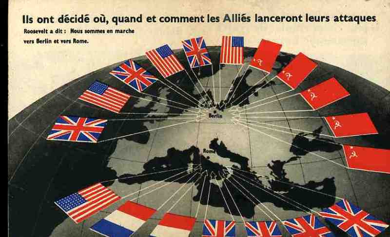
    Nazi Propaganda Map in French

    I’ve made a number of posts about Nazi propaganda maps and thought that this was perhaps time to surface something that represented an Allied effort in the use of maps in hearts & minds campaigns–in this case it was in French obviously and distributed in occupied France.  . (Note:as is the case with may of the items that I feature on this blog, the following pamphlet comes from a collection that I bought of the Library of Congress.  It was called, simply, “The Pamphlet Collection and was 90,000 items strong.  Or weak..  There was no real organizing principle save for the fact that they were all categorized in some strange way and housed in 2,400 alphabetically-arranged document boxes.  They also hadn’t been touched since about 1948.  What makes the “collection” so spectacular to me is that the majority of the pamphlets in it just don’t show up in any collections, anywhere. It seems natural to surface these things and publish them to the web where they can be either appreciated or forgotten–but at least they’ll still be available for as long as electrons move). 

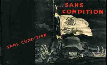
    The occasion for the publication was the meeting at the Anfa Hotel in January 1943 in Casablanca (in the French Protectorate of Morocco) between Churchill, Roosevelt and De Gaulle (Stalin deciding he was too busy with the Nazi invasion to attend.  The full trio of the Americans, British and Russians would meet later in November at Teheran). The Casablanca Conference mapped out the Allied strategy for the rest of the war while trying to figure out how to help the Soviets. The map blatantly relates the closing of the collar around the shrinking neck of the Nazi nation, especially with what was seen as the impending defeat of the German forces in Russia. I suspect that the pamphlet was really published after the massive surrender of German troops at Stalingrad at the end of January–this would explain the forward motion of the red flags. The pamphlet cover calls now for the unconditional surrender of the German forces called for in Casablanca.  The text explains to the French reader that the downward spiral and defeat of Germany was inevitable, and that nothing less than complete and unconditional surrender would be acceptable. In any event the images and the map were completely understandable, even without language, calling quick and immediate attention to the new and true and positive developments in the war.

    Blogaugust30_sans_condition473


  • Longest Rivers in the World–the top 95 in miles

    JF Ptak Science Books LLC Post 216
    Africanqueen3

    Well, all I needed was a list of the lengths of 50 or so of the major rivers int he world, and I just couldn’t come up with one easily, so I threw this together this very simple list of the top 95 rivers by length.  The ironic point here is that I own quite a number of antiquarian maps which beautifully display this data–I just couldn’t find the data in a digital/manipulable form. It would be nice to have the areas drained by each and some other factors, but this is all I needed for the map store, and so I’ll share it here.  There are two lists below, the first listing the rivers by length and the second listing them alphabetically. 


    By Length (River Name, Continent, Length in Miles)

    Nile Africa 4132       
    Amazon South America 3900      
    Yangtze Asia 3430      
    Hwang Ho Asia 2093      
    Congo Africa 2900      
    Amur Asia 2802      
    Lena Asia 2653      
    Mackenzie North America 2635      
    Mekong Asia 2600      
    Niger Africa 2590       Fitzcarraldo

    Yenisey Asia 2565      
    Missouri North America 2466      
    Parana South America 2450      
    Mississippi North America 2330      
    Irtish Asia 2300      
    La Plata Paraguay South America 2300      
    Volga Europe 2293      
    Ob Asia 2260      
    Madeira South America 2060      
    Indus Asia 1980      
    Purus South America 1900      
    St. Lawrence North America 1900      
    Rio Grande North America 1885      
    Brahmaputra Asia 1800      
    Orinoco South America 1800      
    Sao Francisco South America 1800      
    Yukon North America 1800      
    Danube Europe 1770      
    Darling Australia 1750      
    Salween Asia 1730      
    Euphrates Asia 1675      
    Syr Darya Asia 1653      
    Zambezi Africa
    Tocantins South America 1640      
    Araguaia South America 1630      
    Amu Darya Asia 1628      
    Kolyma Asia 1615      
    Murray Australia 1600      
    Angara Asia 1550      
    Ganges Asia 1550      
    Pilcomayo South America 1550      
    Ural Asia 1522      
    Vilyuy Asia 1513      
    Arkansas North America 1450      
    Colorado North America 1450      
    Irrawaddy Asia 1425      
    Dnieper Europe 1420      
    Aldan Asia 1392      
    Negro South America 1305      
    Paraguay South America 1290      
    Kama Europe 1261      
    Xingu South America 1230      
    Don Europe 1224       The_bridge_on_the_river_kwai_dvd__l

    Ucayali South America 1220      
    Columbia North America 1214      
    Saskatchewan North America 1205      
    Jurua South America 1200      
    Peace North America 1195      
    Orange Africa 1155      
    Tigris Asia 1150      
    Pechora Europe 1118      
    Dvina Europe 1100      
    Tobol Asia 1093      
    Snake North America 1038      
    Uruguay South America 1025      
    Red North America 1018      
    Churchill North America 1000      
    Maranon South America 1000      
    Ohio North America 981      
    Magdelna South America 950      
    Roosevelt South America 950      
    Godavari Asia 930      
    Si Asia 930      
    Oka Europe 920      
    Canadian North America 906      
    Dnestr Europe 876      
    Brazos North America 870      
    Salado South America 870      
    Fraser North America 850      
    Parnaiba South America 850      
    Colorado North America 840      
    Rhine Europe 820      
    Narbada Asia 800      
    Athabasca North America 765      
    Donets Europe 735      
    Pecos North America 735      
    Green North America 730      
    Elbe Europe 720      
    James North America 710      
    Ottawa North America 696       Drums_across_river

    White North America 690      
    Cumberland North America 687      
    Gambia Africa 680      
    Yellowstone North America 671      
    Tennessee North America 652 


  • Unusual Maps: Cartographic Displays of Comparative Distance–Supplying Great Britain in 1940

    JF Ptak Science Books LLC  Post 209

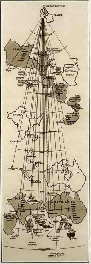
    Blogaugust_21_ww2_map_odd423 This map comes to us from The Illustrated London News, 3 August 1940, which reproduced it from an article in Fortune Magazine.  Though it looks oddly wrong from the outset, it really is pretty lucid–elegant, even–once you understand its purpose.  And the purpose of this map was to show the distances that the goods and raw materials from the British Empire (and from the possessions of France) had to travel via the then-closed Suez Canal route versus the new routes “not open to enemy interference” to Great Britain.  Countries depicted in outline show the distance via Suez while the same country depicted in shade show the new, longer, non-Suez route.  Ever stiff lipped, the Brits announced that even though some of their major natural resources are coming from these vastly removed areas, “even with the fall of France, the British Empire and its allies remain an economically self-contained and immensely powerful war unit, and still control the great part of the world production of some vital commodities…” I’m not sure why, exactly, that it was necessary to display this map to the public eye, what with England under assault in the Battle of Britain (the Nazis extending their aerial assault in preparation for Operation Sealion), the loss of France, and the nearly-there Nazi blockade of English waters.  Perhaps it was drawn to show that even though the material was coming from the same places that were now further away, they were still getting there. 

  • Ghost Trails of the Mississippi River: Harold Fisk’s Geological Map of 1944

    JF Ptak Science Books   Post 144

    Fisk map plate 22

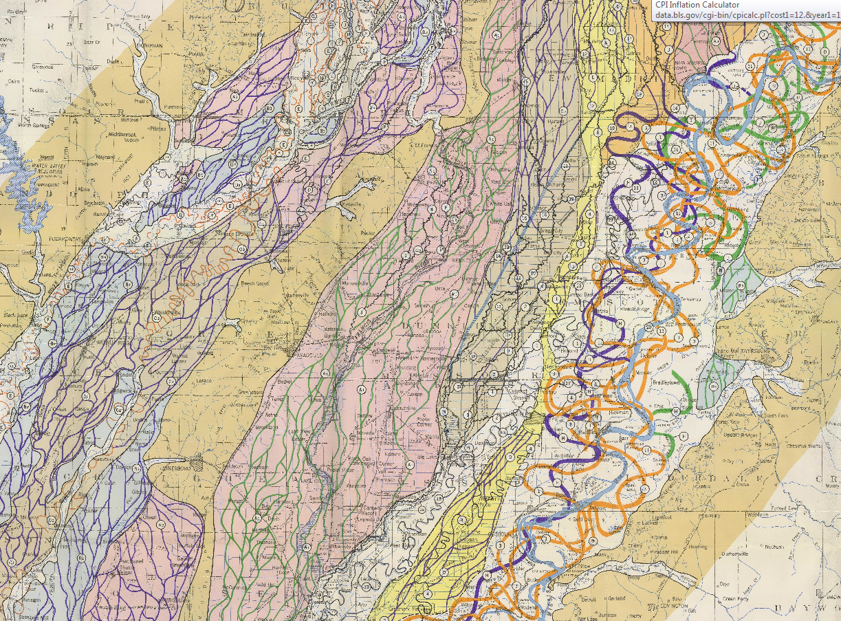
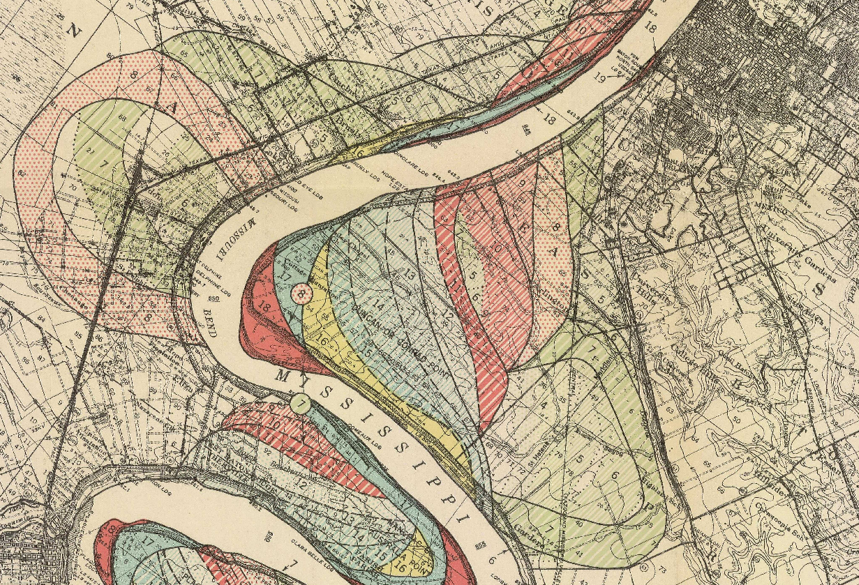
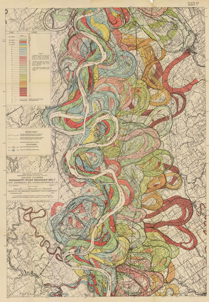
    Understanding the Mississippi River was the skeleton key to understanding pre-Civil War America.  There was really nothing else quite like it—the Ohio River and the attention paid it by Collot and others  was of great importance to understanding the early far Western (east of the Mississippi River) adventures of Colonial and Post-Revolutionary America, as was the Missouri to early 19th century American exploration and settlement, but the Mississippi loomed over all.  Like saying that Babe Ruth was a fabulous baseball player or that Richard Feynman was a brilliant physicist is a bland statement of the obvious—the understatement hollowing and becoming more brittle the more deeply their “records” are studied showing how truly incomparable they were—the Mississippi, “The Father of Waters”, is really the Big Deal in the history of the U.S. 

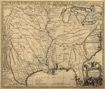
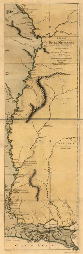
    And in spite of the fantastic maps made of river through the 18th and 19th centuries (like these gorgeous and iconic examples by John Senex in 1721 (A map of Louisiana and of the river Mississipi [i.e. Mississippi] : this map of the Mississipi [i.e. Mississippi] is most humbly inscribed to William Law of Lanreston, esq.)  or Robert Sayer  (Course of the river Mississippi, from the Balise to Fort Chartres; taken on an expedition to the Illinois, in the latter end of the year 1765. By Lieut. Ross of the 34th regiment: Improved from the surveys of that river made by the French. in 1772, or even Coloney & Fairchild’s Ribbon Map of the Father of Waters (below, a whopper, measuring in at 337 cm (and which was issued on a wooden spool for the use of travelers on board steamships moving along  the river), there were very few that gave you an idea of the *history* of the river.

    That was achieved in spectacular flourish by  Harold Fisk (in the map above) in 1944 in his Geological Investigation of the Alluvial Valley of the Lower Mississippi River (U.S. Department of the Army, Mississippi River Commission, 78p) The map showed the very ghost trails of the river over time, and trying to show where it wasn’t was the great question.  He tried to reveal the history of the valley by mapping  and dating all physiological features of the river and tried to reconstruct the channel changes with what were to become speculative appreciation.  Nevertheless, he did make a tremendous attempt at explaining the courses of the Mississippi over time by utilizing his own excellent maps and a little generative thought.  This might not be the most accurate map of the courses of the Mississippi over time, but in 1944 it was really a spectacular achievement in cartography and general thought.  And the thing was just drop-dead beautiful.

    Here’s another sample from the suite of maps:

    Fisk Map

    [Source: http://biotech.law.lsu.edu/climate/mississippi/fisk/plate_15-1.pdf]

    And another detail, from map 15, in the vicinity of Baton Rouge:

    Fisk map baton rouge

    • The full text is available here from the LSU library: http://biotech.law.lsu.edu/climate/mississippi/fisk/fisk.htm
    • For a very quick, elegant overview see Radical Cartography which has all 15 of the maps displayed at once, along with a key chart :  http://www.radicalcartography.net/index.html?fisk
    • Also go to the U.S. Army Corps of Engineers site and click on the “Fisk oversize” link in the left-hand “documents” column:  http://lmvmapping.erdc.usace.army.mil/index.htm


    Mississippisenex

    Mississippi_1765

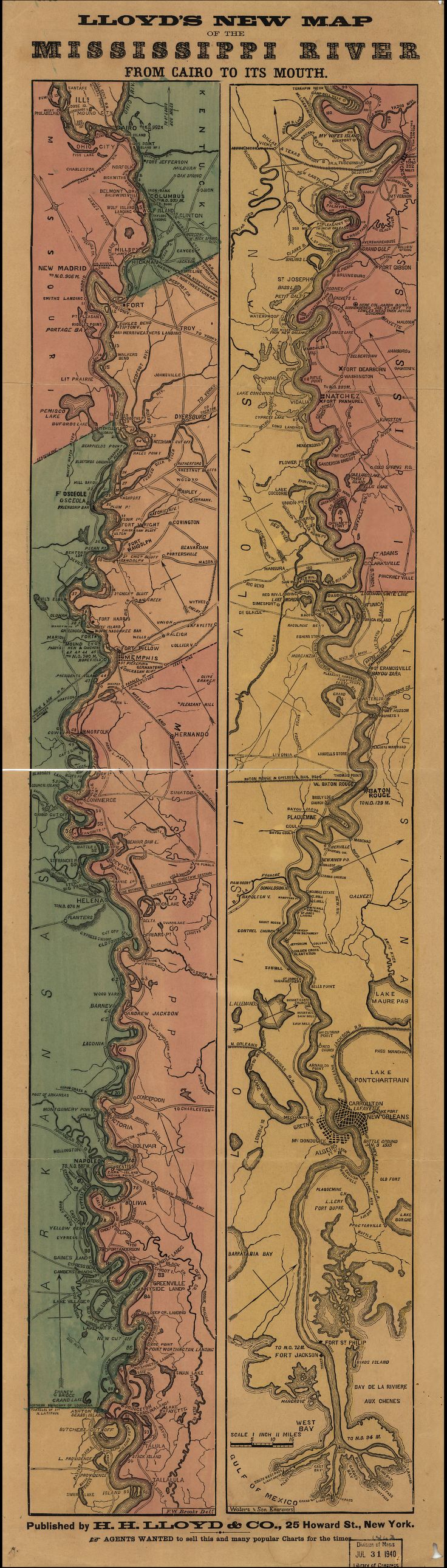
    Lloyd’s new map of the Mississippi River from Cairo to its mouth:

    Mississippi Lloyd map[Source: Library of Congress, http://www.loc.gov/item/99447107/]


    And the great “Ribbon map of the [Fa]ther of Waters.Created / PublishedSt. Louis, Mo. : Coloney & Fairchild, 1866”: 

    (Very zoomable version here:  http://www.loc.gov/resource/g4042m.ct000797/  The initial image comes up about 4mm wide (1)–don;t be discouraged, just start clicking away at the magnifier and it will zoom right in…)

    Mega-long scroll follows:


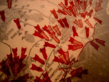
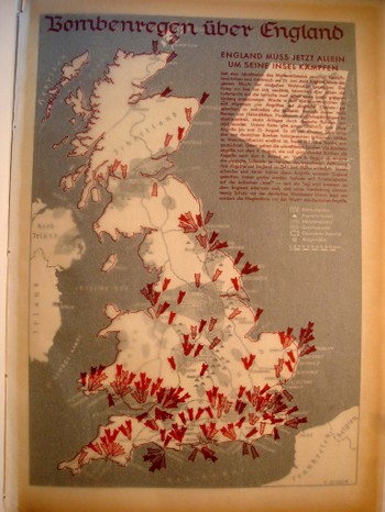
  • Bombing Britain, 1940–a View of the Battle of Britain from Germany

    JF Ptak Science Books  (an earlier post edited and expanded)

    Dsc04742_2
    It is essential to look at objects from alternative angles, especially in science, in order to determine the correctness, or fitness, of a finding, or opinion.  Even when consolidating data or evidence regarding the confirmation of an established bit,  you may very well find other strands of loose data that could help illuminate even a well established or iconic societal “given”.

    That the war was not going well for the Allies in September 1940 is an understatement—and the chief allies at this point excluded the United States, happily now recovering from the Depression, and still a full 14 months away from entering the war. 

    Dsc04739

    What is very weird to me is that after having looked at every issue of LIFE magazine at least three times  from the start to the end of World War II, that there are more advertisements using war images than there are images of the war itself.  This actually continues into the spring of 1942, when LIFE got really busy, the war got really messy, and people started really dying.  And frankly even the coverage of Pearl Harbor in no way lived up to what I thought the coverage of a photo-magazine like LIFE would be. This is not a scientific study.  It just strikes me as odd, or propagandizing, that there should be such relatively scant, or undervalued, coverage of the fighting when sanitized images of that same fighting were being used to sell socks and shaving cream and cigarettes and such.  I understand the power of hearts-and-minds campaigns, but this seemed so amateurish, boorish even, that it just didn’t approach the level of a psychological ploy to pacify an American public that had virtually no interest in attending the European Theatre. 


  • The First American Map Showing Elevations at Which Trees are Found

    JF Ptak Science Books LLC  Post 7

    U.S. Western Botanical Profile of Forest Tress, 1854. 

    U.S. Pacific Rail Road Explorations and Survey, War Department.  Botanical Profile Representing the Forest Trees along the Route Explored by A.W. Whipple…From Fort Smith to San Pedro….

    Published in Washington, D.C.:  1854.  Prepared by J.M. Bigelow (botanist of the Expedition), and printed by Wagner and McGuigan by lithograph in Philadelphia.  47”x21”, printed in many colors.

    (Here we see a detail of a 2×3″ section for the map for the San Francisco Mountains range.) 
    Dsc04524

    This spectacular map presents the forest trees encountered by Whipple on his expedition for the USPRR from Fort Smith (Arkansas) to San Pedro ( actually Los Angeles, California).  The profile shows the trees and their leaves at the elevations encountered—actually the trees are graphically represented by either their shape or their leaves, each of which stand no more than ¼ inch tall.   There is a key explanation to the tree symbols at bottom left identifying 42 different trees—including the Cereus Giganteus, which first identified only a few years earlier.  There are three levels of graphical representation depicting the route containing more than 250 small images of trees.  This is a charming and informative graphical display of data, and is one of the first published efforts to share this information–it certainly seems to me that this is the first representation of the elevation at which trees in the United States and territories might be found.  Humboldt’s map is certainly earlier, and there are occasional mentions of tree regions (worldwide and in general) that can be found in the atlas to accompany von Humboldt’s Kosmos, but there is certainly nothing this large and detailed and exactly.  This is just a very cool map.