A Daily History of Holes, Dots, Lines, Science, History, Math, Physics, Art, the Unintentional Absurd, Architecture, Maps, Data Visualization, Blank and Missing Things, and so on. |1.6 million words, 7500 images, 4.9 million hits| Press & appearances in The Times, Le Figaro, Mensa, The Economist, The Guardian, Discovery News, Slate, Le Monde, Sci American Blogs, Le Pont, and many other places… 5000+ total posts since 2008.

Category: Maps, Cartography, History of Mapmaking

  • Maps of Imaginary Places, Part III–a Preliminary Listing of Images

    JF Ptak Science Books  Post 1469

    “To wander in an empty cave / Is fruitless work, ’tis said: / What must it be for one like me / To wander in his
    head?”–Selected Letters of Lewis Carroll, 5t, to Margaret Cunnyghame.

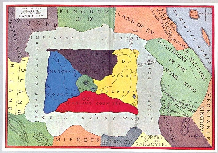
    This is part of a developing thread on the mapping of imaginary places–primarily in work that is done before, say, 1900. There’s much more imaginary cartography in the 20th century than in the entire history of cartography preceding it, and 1900 jsust happens to be a nice arbitrary cut-off date which also coincides with L. Frank Baum’s map of his The Wonderful Wizard of Oz. 

    And so what follows is a simple list, a familiar placeholder for the cumulative list which will soon follow.


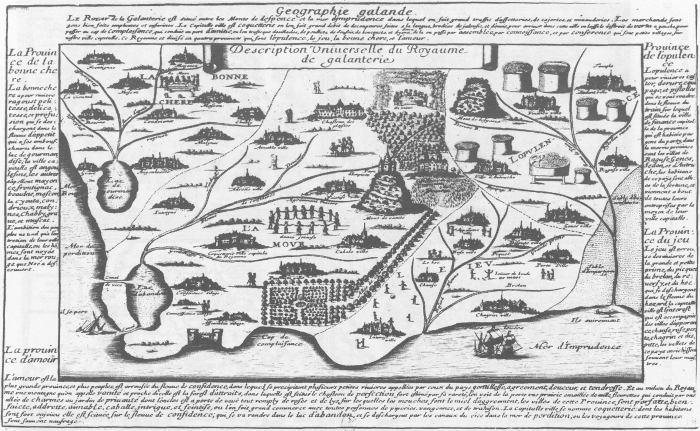
    Voyage au Rayaume de Galanterie (1652), by Delphine Denis. ( In:  Espaces classique, volume 34, numéro 1-2, hiver 2002, p. 179-189.  Source here.)

    Maps imagination galantrie

    Map of the Location of Eden,  1785:

    Eden 2358

    The mostly-imagined coastline of Australia, one of the earliest speculations on the place, ca. 1593:

    CORNELIS DE JODE Novae Guinea
    (Novae Guinea. From the Speculum Orbis Terraum published in Antwerp in 1593, by Cornelius de Jode.  The first landfall in “real-life” wouldn’t be made their until 1605/6, and so the speculation on the existence of Australia was fancifiul and based mostly on hearsay, unsubstantiated data and hope.)
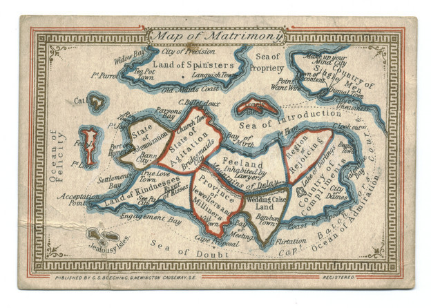
    Map of Matrimony, chromolithographed ca. 1870:
    Aps imagination  z matrimony

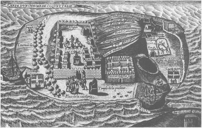
    Map of the Kingdom of Coquetterie
    Maps Imagination--royaume de Couquetterie
    Royaume de Coquetterie, by J. Sadeler.
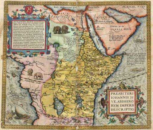
    Kingdom of Prester John
    Maps Imagination map_prester_john_by_ortelius_1572
    Map of Prester John’s realm, by Abraham Ortelius (1527 – 1598), 1572.  The kingdom of Preser John was supposed to be that of exiled Christians surrouned by non-believers, set in Central Asia, or norther Africa, or India, or Ethiopia.  Bordering such places as Paradise and the Fountain of Youth, and ruled by a descendent of one of the Three Magi who was wealthy and benevolent, this place was an object of much travel and considerable expectations. 
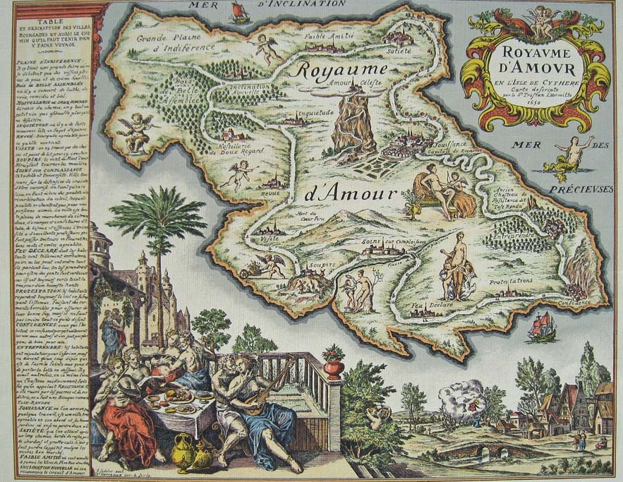
    Royaume d’Armour, by J. Sadeler, ca. 1659. 
    Maps imagination carte-du-royaume-damour
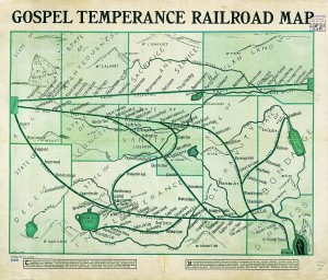
    G. E. Bula, “Gospel Temperance Railroad Map” (1908), unearthed by Frank Jacobs at Strange Maps.

    Gospel Temperance Railroad Map


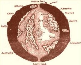
    Map of interior world, from “The Goddess of Atvatabar” (1892) Maps Imagination Z Atvatabar
    by William Bradshaw:


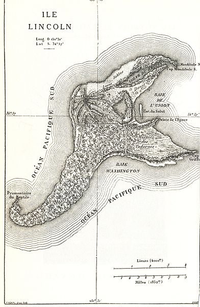
    Map of Isle Lincoln, from Jules Verne Mysterious Island, 1874:

    Maps imagination Z mysterious island

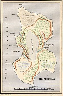
    And another from Verne: Two Years’ Vacation (Deux ans de vacances), Chairman Island:

    Maps Imagination Z  Chairman Island
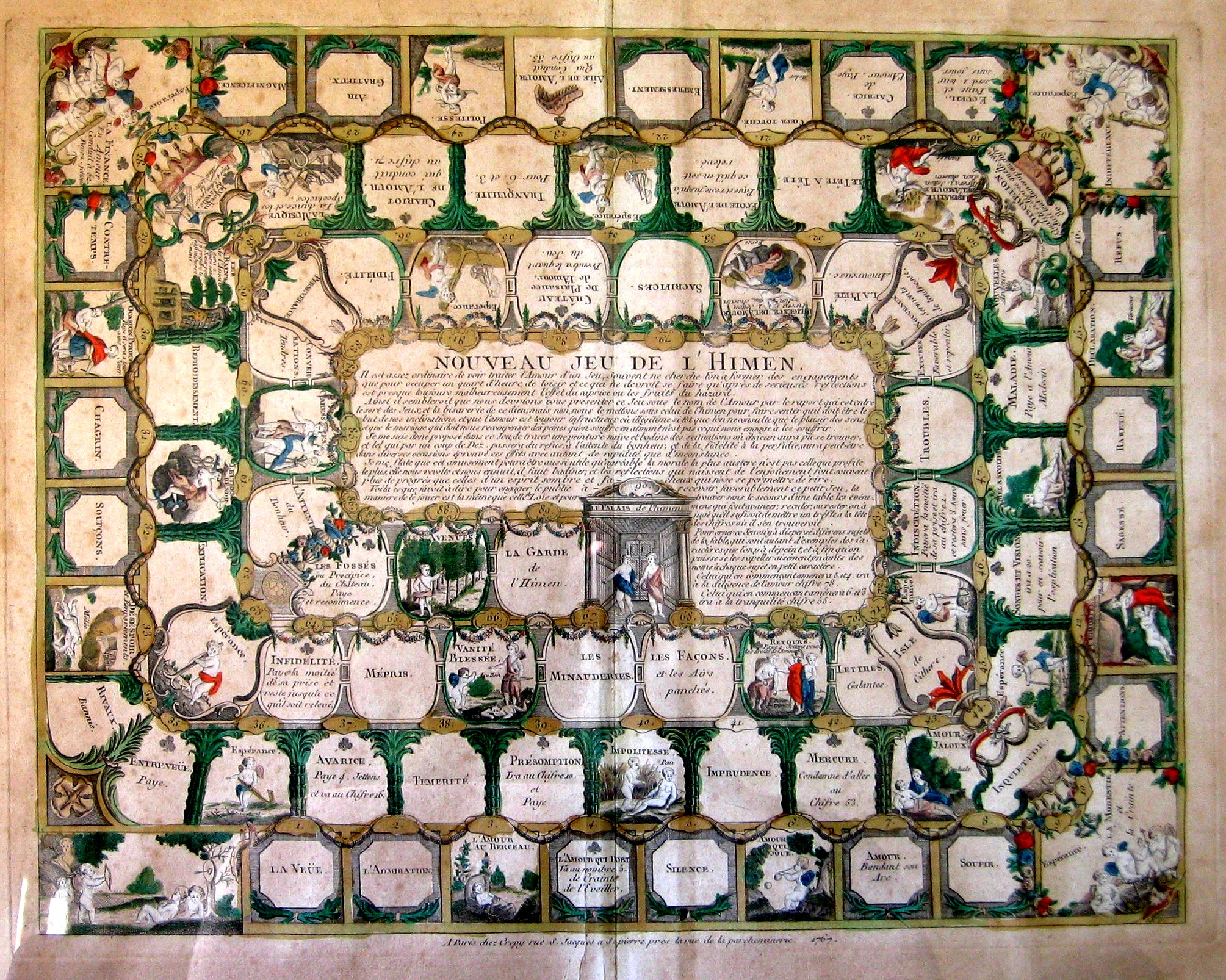
    Nouveau jeu de l’Himen

    Maps Imagination Himen
    Complete description here.

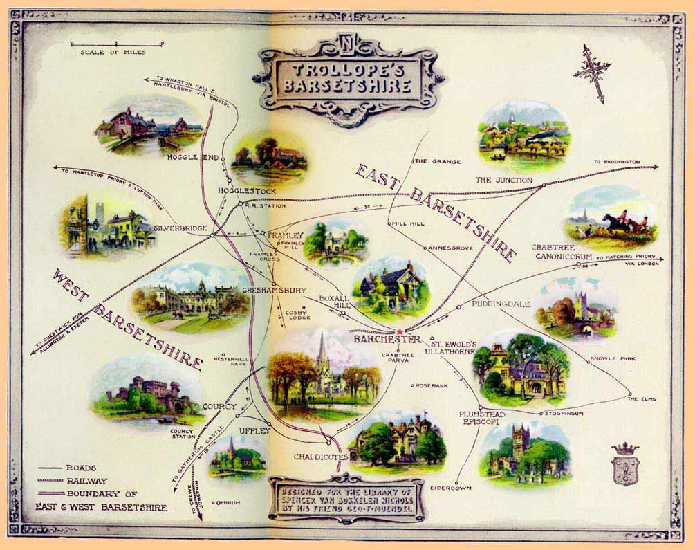
    Barsetshire, from the novels of Anthony Trollope:

    Maps Imagination Z  Trollopes

    the-road-to-success


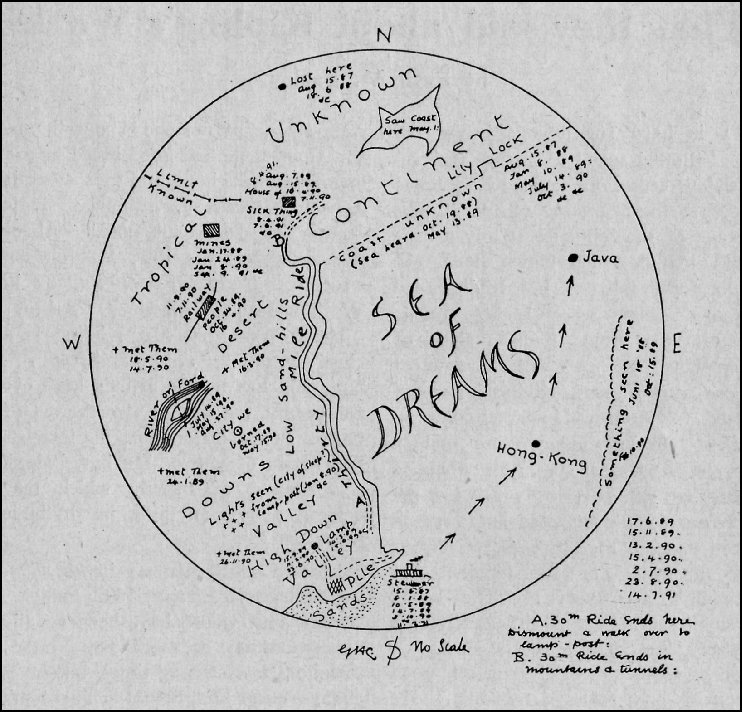
    Rudyard Kipling’s (George Coattar’s)  map of the Sea of Dreams from the “Brushwood Boy”,

    Maps Imagination  Z  brushwood_map_800

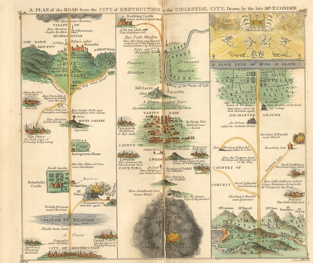
    Pilgrim’s Progress, 1840.

    photo
    The engraving is Thomas Conder’s, originally printed in A. Hogg’s 1778 edition.

    Map of Oz, or at least the first map of Oz, as it appeared in L. Frank Baum’s book The Wonderful Wizard of Oz in 1900:

    Maps of Imagination Z  Oz-and-surrounding-countrie

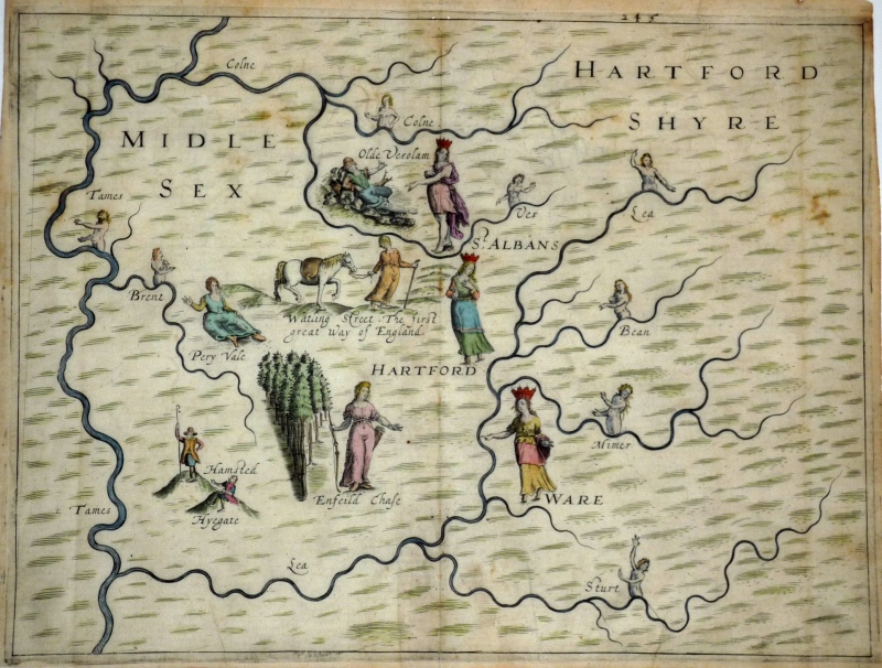
    Michael Drayton’s  (1563-1631) love-poem to England and Wales, the Poly-Oblion (published in 1612), mapped the reaches of the two countries and decorated them with allegorical iamges–it seems to me that the images were given far more work an understanding than the maps, which come off as outlines and suggestions of the real thing. (The maps were interestingly the work of one of the earliest British mapmakers, William Hole.)

    Map of Imagination-Michael-Drayton-s-PolyOlbion-c-1613

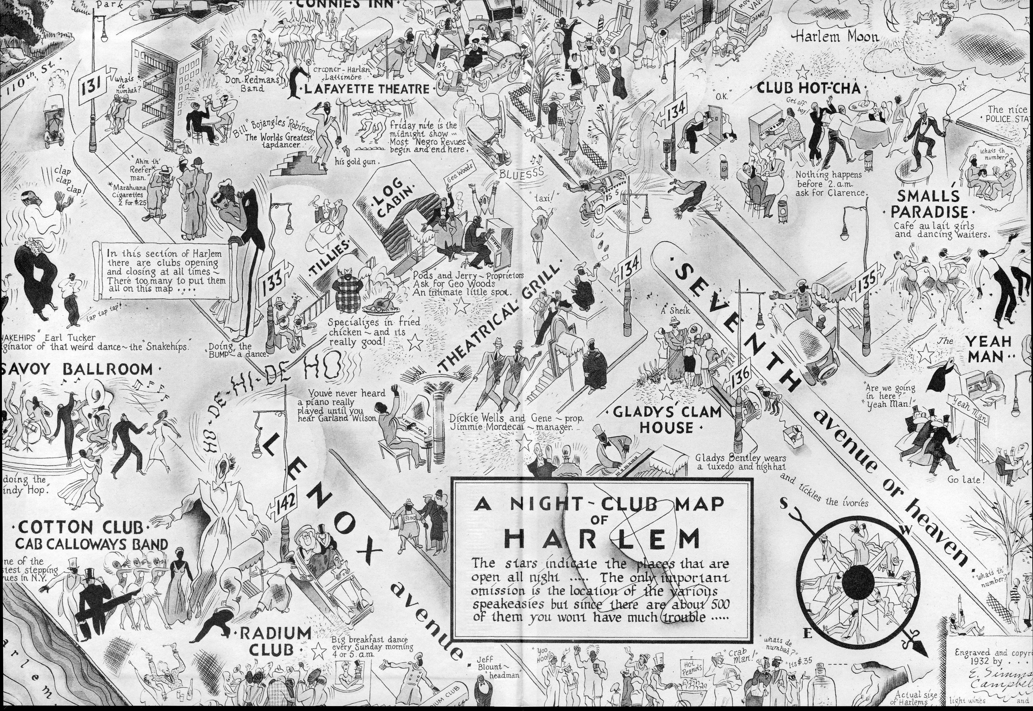
    Map of Harlem Nights, 1932, a fantastic map of a real place and real people and real happenings that I just couldn’t leave alone.  It doesn’t belong here–I just like it. 

    Maps imagination harlem


    Heinrich Bunting, 1581. 

    MAPS iMAGINATION eUROPA pRIMA buNTING vIRGIN

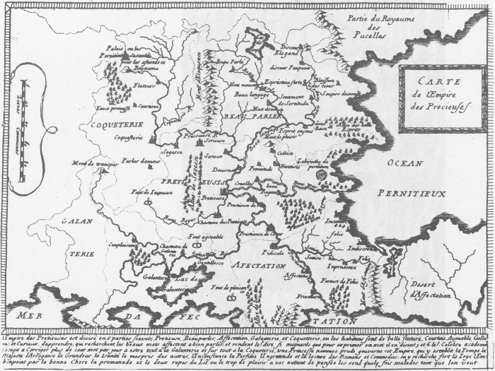
    Map of the Empire of the Precieuse, 1652.

    Maps Imagination Carte de l’Empire des Precieuses,

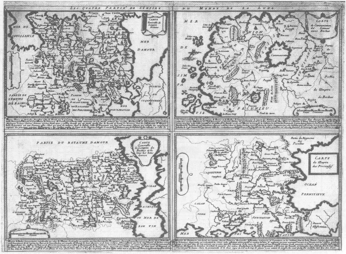
    Les Quatre parties de l’Empire du Monde de la Lune

    Maps Imagination Les Quatre parties de l’Empire du Monde de la Lune

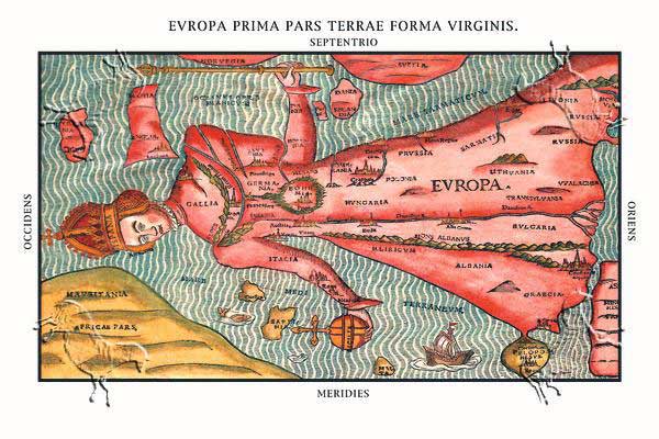
    Clover-leaf map of the world, 1581, a wonderful map designed to increase the savoir faire of the mapmaker Heinrich Bunting’s hometown of Hannover, which appears at the center of the map.  I have a map somewher here that depicts world trade and the importance of Knoxville, Tennessee–the only city depicted on the map.


  • The Cosmology of Creation, 1554

    JF Ptak Science Books   Quick Post

    Biblia germanica419
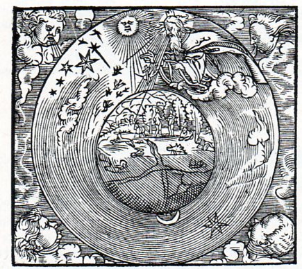
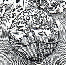
    This woodcut comes to us from Biblia: Dat ys De gantze Hillige Schrifft Vordudeschet dorch D. Mart. Luth. Vth der lesten Correctur mercklick vorbetert, and published in Mageburg by Michael Lotter in 1554.  I’d say that it depicts the Eath-centered cosmology of the creation just after the introduction of Eve, where everything seems to be in perfection and harmony, there (perhaps) inthe sixth day of the creation story.

    In the detail we can clearly see the Garden:

    Biblia germanica419

    There doesn’t seem to be any sign of the serpent, though Eve does seem to be covering herself in some sort of modesty, even though we are told in the OT that the two humans were naked but not ashamed.

    The world seems to be divided into quarters, following the symbolic depiction of the world into sections, though more commonly seen as a three-section map,m the T-O, as seen below:


  • The Topography of Emotion, 1654–a Visit to Lake Indifference in the Land of Passion

    JF Ptak Science Books   Post  1459

    (Part of a new series on the mapping of imaginary places.) My thanks to Natalie Bouchard (Montreal, PQ, Canada) for suggesting this map.

    Tendre_gr
    [A massively expandable version of this map is available from here.]

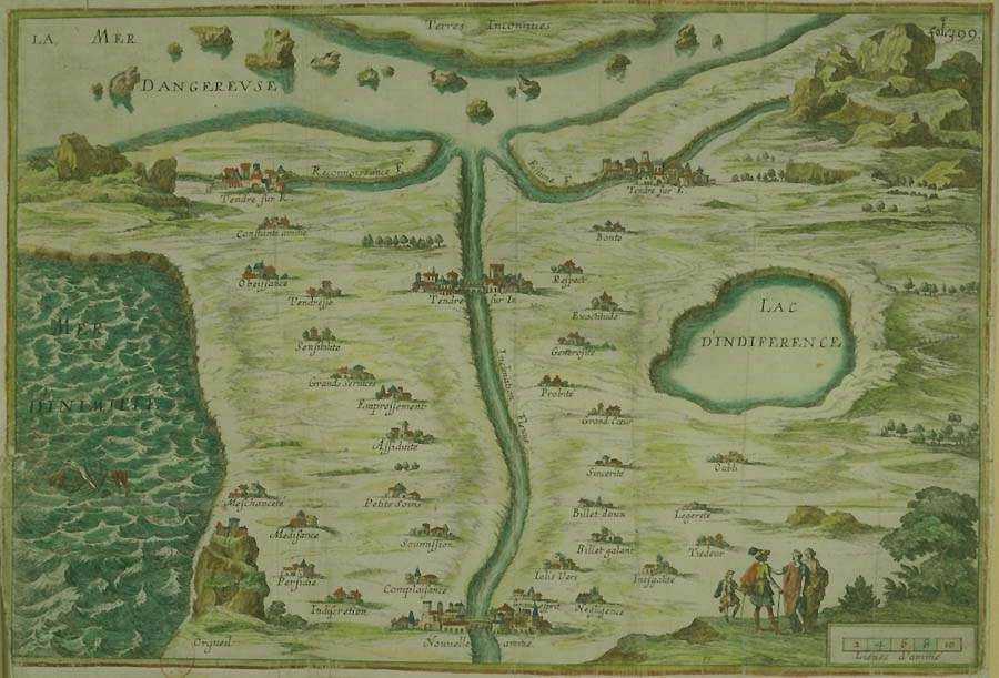
    This is an old , seemingly simple but somewhat deceptive map, drawn for the work of Madeleine de Scudery’s (1607-1701)  novel Clelie, and published in 1654.   It is for all intents and purposes a little more than its stated name (Tenderness, Carte de Tendre), diving deeper in the psycho/sexual area than anything else.  On the other hand it may be exactly what you want it to be–evidently many people did, as this map turned out to be used as  a very popular proto-game board in polite Salons.

    As a map of friendship and caring and love and sexual adventure, it is interesting that what seems (to me) to be the stand-alone focal point battling for our initial attention is the The Lake of Indifference–it just seems to me to be the first thing that the eye sees, the map’s most dominant geographical fixture.  It is not the largest feature, nor the most spectacular, but it does seem to capture the essence of what may be  one of the most ordinal of sins:  indifference is a suffocating malaise, a semi-disease, that covers an extraordinary amount of ground without even trying, a force invisible and while so immutable, a host to all manner of impending failures.  Indifference may be the worst thing going for humanity in general, as it allows oxygen for so much of the nastiness to burn.  Solidified hate is a much easier thing to deal with and potentially manage than a hate distilled and vaporous and filtered to a greater number of uncaring/discaring people. 

    And speaking of impending doom, one of the other main features of the map is the long, semi-straight river that feeds into the body of water at the top,  the Sea of Danger.  Now the Sea of Danger doesn’t appear so dangerous, except for the jagged island bits exploding from its calm, flat and not-detailed surface, though perhaps that is the very point.  The large river is called the Inclination–translated to a natural disposition, a “normal” way of doing things, a common bent, which means that the mapmaker says that our standard approach to life is to head towards the deceptive sea of danger. 

    Even though we are headed that way it doesn’t mean that we can get off the river and visit, or stay, in any of the many towns that we see along the way.  There are a number of alluring towns with charming names:  alacrity/cheery readiness (Empressement); assiduity (Assiduite); eagreness (Empressement); favors (of perhaps a sexual kind, Grands Services); (lasting) friendship (Constante Amitie); kindness (Complaisance); obedience (obaissance); pampering (Petits Soins); sensibility (Sensibilite); submission (Soumission);  and tenderness (Tendresse) are all places calling out for attention.  The other town names are further indications of the personal stabilities that are the goals of most people:  wit, sincerity, generosity, punctuality, respectfulness and goodness.
    There’s also those other places, towns of a more sinister and betrayed nature that form a north-south line east and west of the river:  Negligence, Inegalite, Tiedeur (tepidity), Legerete (lightness, not being there), Complaisance, Perfide, Meschancete (wickedness), and so on.  And don’t forget the town of Oubli (oblivion). 

    At the last moment, before entering the Sea of Danger (which is fed in the east by the much more volatile waters of the Mer de Inimittie (Sea of Enmite) , the River Inclination  is joined by the smaller rivers of Estime (Respect) and Reconnaissance (Gratitude), a mixing of waters all coming together at the same point, a combination that I do not understand. I have no doubt that there are abundant clues to all of this throughout the ten volumes of her novel, but I can’t give Mme. de Scudery that much time. 

    Maybe none of the placements and proximities in this map matter–maybe the rivers are flowing backwards or something, being filled by the waters from the Sea of Danger.  Maybe this isn’t a map at all, but just a suggestion of what stuff might look like, a spatial suggestion of the concept of emotion.  Or maybe it is just a board for a polite game. 


  • On Missing Antique Atlases of Imaginary Places and the Sameness of Alien Math and Music: Huygens’ 1698 ETs

    JF Ptak Science Books    Post 1458  [With thanks to Rich Lewis, Dickinson College, who found and suggested some remarkable cartographical curiosities!

    I was thinking about the history of atlases of imaginary places [in Western culture] composed before, say, 1900, and I had a hard time coming away with any.  Lowering the sites to a series of maps relating to the same idea didn’t help–its only when you get down to the single-map level that I found some results.  But even there, at the basic representational level of an imaginary place, there aren’t really that many examples, at least compared to the rich narrative life of created space.

    I wonder why that is? 

    If you widened the scope a bit you might look at the night sky as being a sort-of map locating ancient deities, but the sky is really just a picture book with dislocated images without very much to do with one another. 

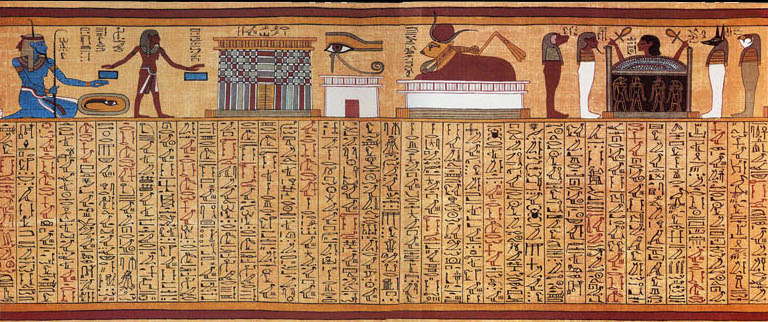
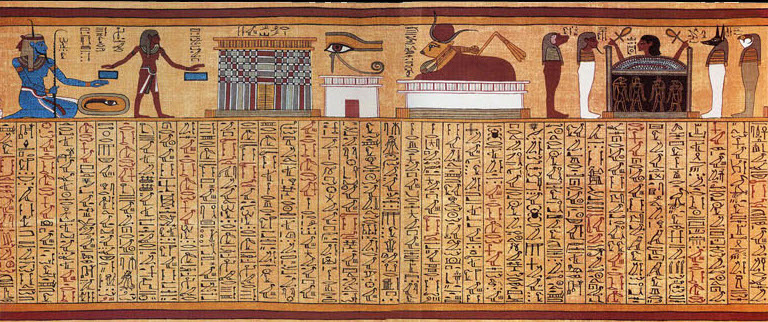
    Books of the Dead1 kind of fit the bill, but how come there aren’t any surviving ancient maps of Olympus, or
    Bookofthedeadspell17
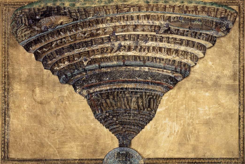
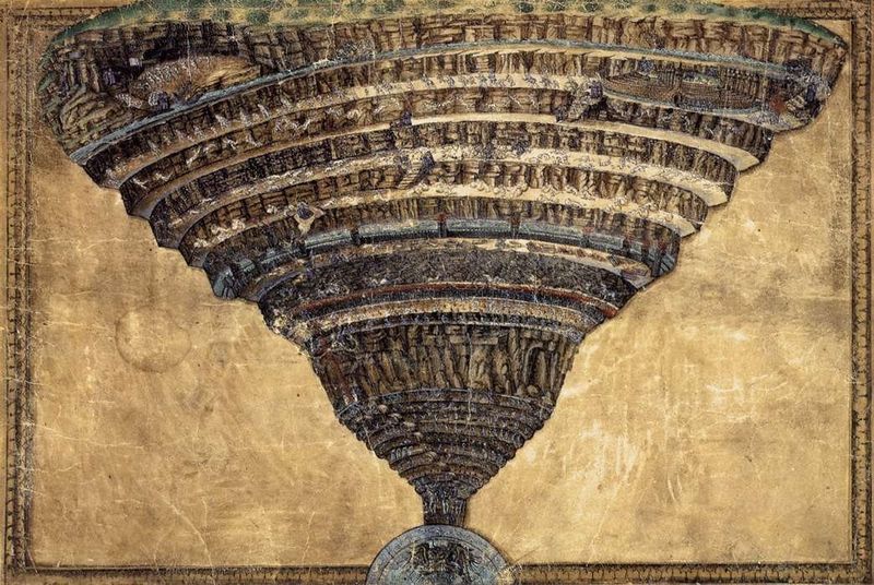
    Heaven for that matter?   The Heaven, and Hell, and Purgatory part does get mapped and mapped pretty heavily after Dante reaches the scene–there are at the very least dozens of cartographic/pictographic representations of the worlds that he surveyed in the Divine Comedy.  For example, there is this spectacular effort by Sandro Botticelli (being a drawing on parchment executed ca. 1480-1495):
    Hell_its_representation_through_the_ages

    The Botticelli is a scary accomplishment, frightening and heavy–you can almost feel the very burden of Hell coming down upon you. (Here’s a good link for a zoomifying version of this map so that you can see its elements in detail.)

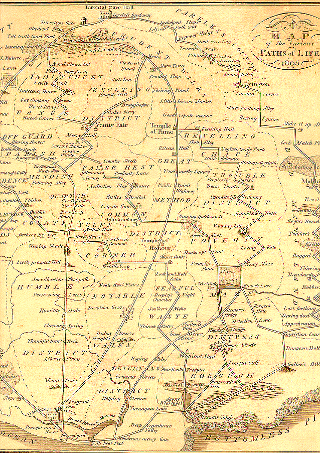
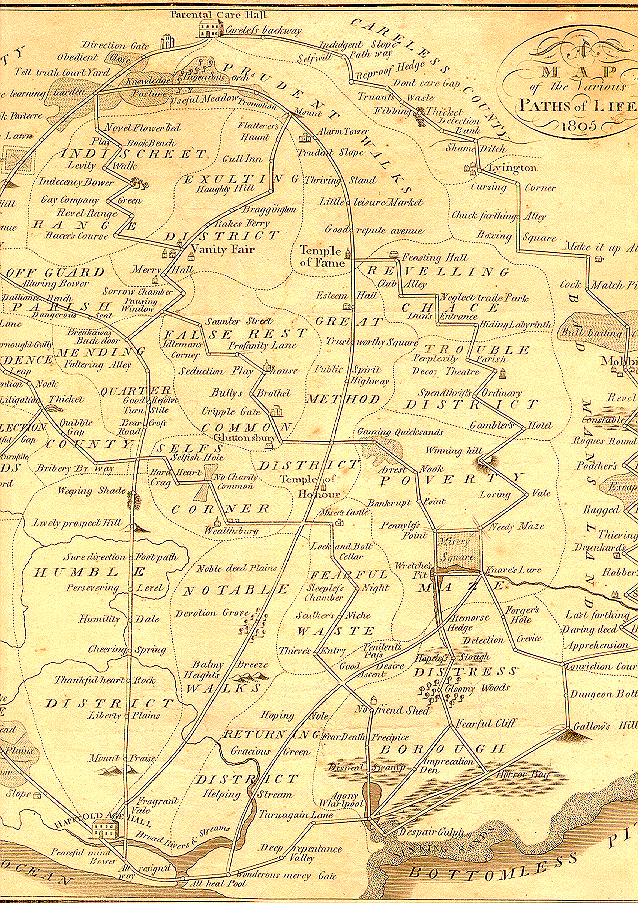
    Then there are allegorical maps that show the stages and stations of life, the progress of the arts and sciences.  A fine example here is a work by B. Johnson, who in 1805 published this fantastic map of the possible paths for living one’s life:
       Maps of Imagination
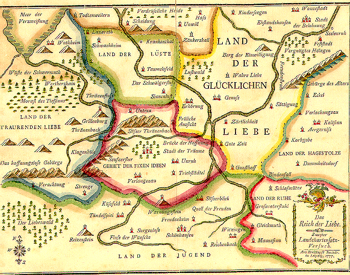
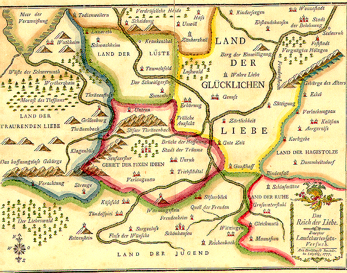
    which seems to tell the reader to keep away from the southeast. Another  map, this one earlier, printed in 1777, is by J.G.I. Breitkopf, Das Reich der Liebe (The Kingdom of Love):
    Maps of the imagination--
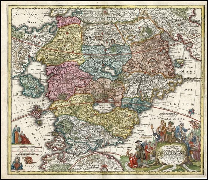
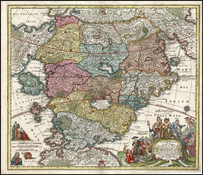
     Another fantastic example of mapping the imagination is found in Matthaus Seutter’s Accurata Utopiae Tabula. Das ist Der Neu entdeckten Schalck Welt, oder des so oft benannten und doch nie erkannten Schlarraffenlandes, published in 1730.  It depicts a Utopia of sorts, though not the world of Thomas More–this is like a pyrite of utopias, a fool’s gold, a fools’ paradise:
    Maps of imagination  utopia

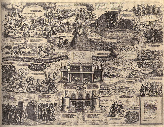
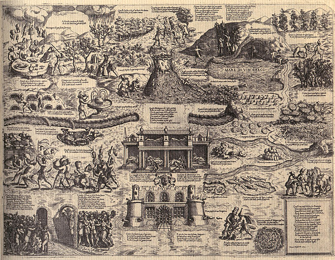
    This land is much like the land of Cockaigne, a mythical Medieval/Renaissance place of plenty, which is pictured below in an image made by Niccolop Nelli in 1564:
    Cockaigne1
    (It is interesting to picture these places of plenty and sloth in conjunction with some 20th century songs of the Great Depression and earlier, where the land of plenty is far, far simpler–as in the land of the Big Rock Candy Mountain–but that is a different story.)


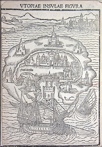
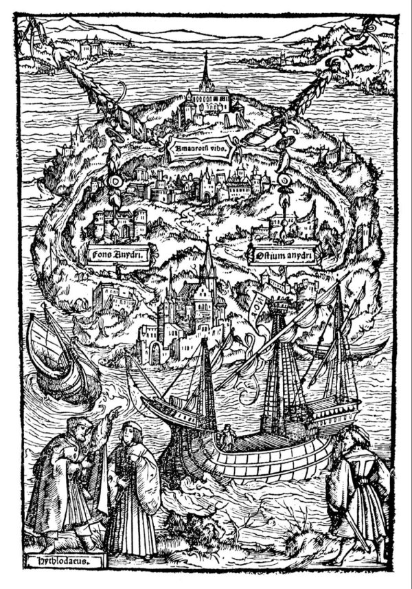
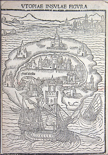
    As long as we’re mentioning Utopia, here’s a 1516 representation of More’s hopefullness, from the first edition of his work:
    Maps imagniation More's utopia 1515

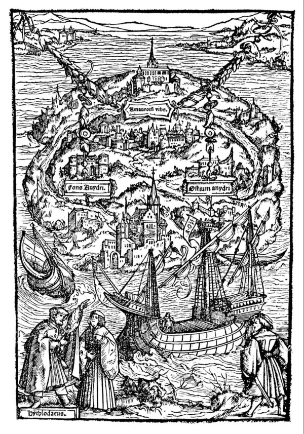
    And another represntation, two years later:
    Maps Imagination more's utopia

    There are more recent examples, but not that many, not so far, anyway.  There are editions of Pilgrims Progress (1678) that contain maps of the travels; there are also a number of charts showing the progress of Mr. Gulliver from the Swift book (1726);  Robinson Crusoe also contains a small sketch map opposite the title-page, and, more recently, R.L. Stevenson’s Treaure Island (1882) contains a map of that place.

    But given the extraordinarily rich tapestries of mythical/mystical places that have been created since the beginning of people telling stories, why weren’t there, well, tapestries (or something) illustrating what the whole of these places looked like?  Why for sample when we meet up with a map of the very pronounced extra-terrestrial wanderings of Cyrano de Bergerac (in his ancient-advanced science fiction work on traveling to other inhabited worlds)?  Taking the antiquarian thought on extra-terrestrials as a case study, why don’t we see more of that sort of thinking illustrated in some way?  The idea of extraterrestrial life is very old, stretching far back into Hindu cosmology, and even deep into the (eighteen worlds) of the Talmud.  Thales, Anaximander, Democritus, Aristole, Ptolemy all thought about and agreed on the possibilities of life being lived on places other than the Earth–infintely more life, in the case of Epicurus. Bruno, Copernicus, Fontenelle, Henry More–were all there, but without visual aids, and certainly without maps.  Except for Fontenelle–Bernard le Bovier de Fontenelle–who almost but not quite gets there in his 1682 book Entretriens sur la pluralite des mondes.

    Blog--plurality of world fontenelle :  

    It seems to me that as a representative of extraterrestrial imagination not being illustrated its hard to beat the case of the beautiful and polymathic Christian Huygens.  Huygens (1629-1685) worked across many fields, including astronomy, biology, math and physics, and was extraordinarily productive, making numerous contributions in the physical and theoretical areas, as well as being a prolific author and correspondant.  But towards the end of his relatively short life (he died at age 56) Huygens embarked down the science fiction road in pre-science fiction days, writing a wonderful and provocative book entitled Cosmotheoros, The Celestial World Discover’d: or, Conjectures Concerning the Inhabitants, Plants and Productions of the Worlds in the Planets3, where he establishes the possibilities of life being lived on worlds other than that of Earth. He developes a detailed fabric for these new heavens,m so much so that he can also establish samenesses for the ETs and humans, stating here his belief in the eternal/cosmoloigcal abilities of mathematics and music:

    “It’s the same with Musick as with Geometry, it’s every where immutably the same, and always will be so. For all Harmony consists in Concord, and Concord is all the World over fixt according to the same invariable measure and proportion. So that in all Nations the difference and distance of Notes is the same, whether they be in a continued gradual progression, or the voice makes skips over one to the next. Nay very credible Authors report, that there’s a sort of Bird in America, that can plainly sing in order six musical Notes: whence it follows that the Laws of Musick are unchangeably fix’d by Nature, and therefore the same Reason holds valid for their Musick, as we even now proposed for their Geometry”pg 86

    Huygens holds close to the immutable nature and close association of music and mathematics,m which would be the same here and everywhere (everywhere else, the ET communities, being referred to here as “other Nations”). 

    “For why, supposing other Nations and Creatures, endued with Reason and Sense as well as we, should not they reap the Pleasures arising from these Senses as well as we too? I don’t know what effect this Argument, from the immutable nature of these   Arts, may have upon the Minds of others; I think it no inconsiderable or contemptible one, but of as great Strength as that which I made use of above to prove that the Planetarians had the sense of Seeing.” pg 86/7

    Huygens is so sure of this that he is willing to tak a bet with long odds that not only do ETs enjoy the possibilities of muic but that they have also created instruments:

    “But if they take delight in Harmony, ’tis twenty to one but that they have invented musical Instruments. For, if nothing else, they could scarce help lighting upon some or other by chance; the sound of a tight String, the noise of the Winds, or the whistling of Reeds, might have given them the hint. From these small beginnings they perhaps, as well as we, have advanced by degrees to the use of the Lute, Harp, Flute, and many string’d Instruments. But altho the Tones are certain and determinate, yet we find among different Nations a quite different manner and rule for Singing; as formerly among the Dorians, Phrygians, and Lydians, and in our time among the French, Italians, and Persians” pg 87

    Huygens then continues to make a beautiful distinction between the musics of Earthling and ETs, in that it may not sound anything like any music we have on Earth, but–since the laws that govern math and music are the same, everywhere–it still might be “very good”.  And not only that, the alien music might be better than our’s:

    In like manner it may so happen, that the Musick of the Inhabitants of the Planets may widely differ  from all these, and yet be very good. But why we should look upon their Musick to be worse than ours, there’s no reason can be given; neither can we well presume that they want the use of half-notes and quarter-notes, seeing the invention of half-notes is so obvious, and the use of ’em so agreeable to nature. Nay, to go a step farther, what if they should excel us in the Theory and practick part of Musick, and outdo us in Consorts of vocal and instrumental Musick, so artificially compos’d, that they shew their Skill by the mixtures of Discords and Concords? pg 88

    And so on.  But why I wonder with all of the great images painted for us in his text is there no venturing into a visual artform?  There’s enough information in the Huygens work to allow for a map, but then there are none, not even something along the images of de Bergerac, who was perhaps among the greatest visionary of techno-anthropormorphic human flight.  Before he was the object of Edmund Rostand’s 1897 play, de Bergerac was a massively creative author, producing, among other things, the book Histoire des Etats et Empires de la Lune (History of the States and Empires of the Moon, published posthumously in 1657), followed by Histoire des Etats et Empires du Soleil (History of the States and Empires of the Sun, again, published further and deeper into his life’s surrender, 1662), both eventually collected as L’Autre Monde (Other Worlds).  Bergerac introduces us, the humble reader, to one of the most important concepts in the history of literature–namely that we humans were not only not alone in the universe, but that we were not even the dominant culture, and indeed we were actually hated by some of the other more advanced species.

    The foundations for structuring a visual habitat for the ideas of Huygens are abundant, as you can see easily in the table of contents (which is like an annotated table of contetns for a modern book) as seen in footnote #4–the signs for a road map are there, mostly–there’s just no road, but there are plenty of suggestions for one.

    So I bring this part of this open discussion to a close—I do ask forgiveness here in the likely case that I’ve left out some obvious examples, this is a Thinking-Out-Loud piece which takes place in the cultures west of the Urals–thinking about where the maps and images weren’t.  Finding almost nothing when you think there’s nothing there is easy to do, especially when you can hold yourself to a porous definition of “nothing”–the next step is harder, finding out how close people came to making these maps, or diagrams, or images.  

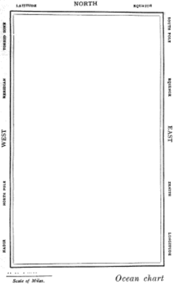
    And having said this about finding nothing I cannot let this piece go without mentioning The World’s Most Beautiful Map:  Lewis Carroll’s map from The Hunting of the Snark, an Agony in Eight Fits, and occurs in the Bellman’s tale, starting the second fit. It begins:

    The Bellman himself they all praised to the skies-
    Such a carriage, such ease and such grace!
    Such solemnity too! One could see he was wise,
    The moment one look in his face!
    He had bought a large map representing the sea,
    Without the least vestige of land:
    And the crew were much pleased when the found it to be
    A map they could all understand.
    “What’s the good of Mercator’s North Poles and Equators,
    Tropics, Zones, and Meridian Lines?”
    So the Bellman would cry: and the crew would reply,
    “They are merely conventional signs!
    “Other maps are such shapes, with their islands and capes!
    But we’ve got our brave Captain to thank”
    (So the crew would protest) “that he’s bought us the best-
    A perfect and absolute blank!”
    Snarkmap

    Sometimes there is nothing so fine as something that beautifully illustrates the nothing that isn’t there, and this lovely map, unencumbered of all of the elements and details that define the mapness of something,  perfectly explains the origin of its need.

    Notes:

    1.  They’re not really the Book of the Dead, but collections of papyrus that each contain a unique set of instructions and magic spells and such to assist its dead reader of getting fromthe dead place into the light, into the afterlife.  This image is a rather famous one, pictured and described in the following Wiki bit:  “The mystical Spell 17, from the Papyrus of Ani. The vignette at the top illustrates, from left to right, the god Heh as a representation of the Sea; a gateway to the realm of Osiris; the Eye of Horus; the celestial cow Mehet-weret; and a human head rising from a coffin, guarded by the four Sons of Horus.“

    2.  Here’s another version of the Dante structures placed in context to the Earth, this image by A. Ritter. 

    3. Following the edition of 1698 translations appeared in English (1698) and in Dutch (1699). In the following years, translations also appeared in French (1702), German (1703), Russian (1717) and in Swedish (1774)
     
    4.  The table of contents (with links) is extremely interesting and tells much of the story of the book:

    Book 1

    • Some have already talk’d of the Inhabitants of the Planets, but went no fartherThe Objections of ignorant Cavillers prevented
    •   This Enquiry not overcurious
    • Conjectures not useless, because not certain
    • These Studies useful to Religion
    • Copernicus’s System explain’d
    • Arguments for the truth of it
    • The Proportion of the Magnitude of the Planets, in respect of one another, and the Sun
    • The Lamell more convenient than Micrometers
    • The Earth justly liken’d to the Planets, and the Planets to it
    • Arguments from their Similitude of no small weight
    • The Planets are solid, and not without Gravity
    • Have Animals and Plants
    • Not to be imagin’d too unlike ours
    • Planets have Water
    • But not just like ours
    • Plants grow and are nourish’d there as they are here
    • The same true of their Animals
    • Great variety of Animals in this Earth
    • And no less in the Planets
    • The same in Plants
    • Rational Animals in the Planets
    • Vices of Men no hindrance to their being the Glory of the Planet they inhabit
    • Reason not different from what ’tis here
    • They have Senses
    • Sight
    • Hearing
    • A Medium to convey Sound to the Ear
    • Touch
    • Smell and Tast
    • Their Senses not very different from ours
    • They have Pleasure arising from the Senses
    • All the Planets have Fire
    • The bigness of their Creatures not rightly guest at by the bigness of the Planets
    • In the Planets are many sorts of rational Creatures as well as here
    • Men chiefly differ from Beasts in the study of Nature
    • They have Astronomy
    • And all its subservient Arts
    • Geometry and Arithmetick
    • And Writing
    • And Opticks
    • These Sciences not contrary to Nature
    • They have Hands
    • And Feet
    • That they are upright
    • It follows not therefore that they have the same shape with us
    • A rational Soul may inhabit another Shape than ours
    • The Planetarians not less than we
    • They live in Society
    • They enjoy the pleasures of Society
    •    They have Houses to secure ’em from Weather
    • They have Navigation, and all Arts subservient
    • As Geometry
    • They have Musick
    • The Advantages we reap from Herbs and Animals
    • And from Metals
    • From the discoveries of our Age
    • The Planets have, tho not these same, yet as useful Inventions 

    Book 2

    • Kircher’s Journey in Ecstacy examin’d
    • The System of the Planets in Mercury
    • In VenusIn Mars
    •  Jupiter and Saturn the most eminent of the Planets both for bigness and attendants
    • The proportion of the Diameter of Jupiter, and of the Orbs of his Satellites, to the Orbit of the Moon round the Earth
    • The periods of Jupiter’s Moons
    • And Saturn’s
    • This proportion true according to all modern Observations
    • The apparent magnitude of the Sun in Jupiter, and a way of finding what light they there enjoy
    • And in Saturn
    • Always the same length
    • They see the fixt Stars just as we do
    • The appearances of the Ring in Saturn
    • Very little to be said of the Moon
    • The Guards of Jupiter and Saturn are of the same nature with our Moon
    • The Moon hath Mountains
    • But no Sea, nor Rivers, nor Clouds, nor Air and Water
    • The Conjecture of its Plants and Animals very dubious Jupiter’s and Saturn’s Moons turn always the same side to them
    • The Astronomy of the Inhabitants of the Moon
    • This may be applied to the Moons about Jupiter and Saturn
    • The immense distance between the Sun and Planets illustrated
    • No ground for Conjecture in the Sun
    • The Faculty in the Sun not easily seen
    • By reason of its Heat no Inhabitants like ours can live in the Sun
    • The fix’d Stars so many Suns
    • They are not all in the same Sphere
    • The Stars have Planets about them like our Sun
    • A way of making a probable guess at the distance of the Stars
    • Every Sun has a vortex round it, very different from those of Cartes 
     

    See: 

    “This Is Not a Map”, by Max Byrd, The Wilson Quarterly  Vol. 33, No. 3 (Summer, 2009) (pp. 26-32).

    John Pickles, A history of spaces: cartographic reason, mapping and the geo-coded world,  (London and New York, Routledge, 2004)

    Katharine Harmon, editor, You are here: personal geographies and other maps of the imagination. (New York, Princeton Architectural Press, 2004).

    Giuliana Bruno. Atlas of Emotion: Journeys in Art, Architecture, and Film (New York, Verso, 2002).

    Denis Wood, ‘Map art’, Cartographic perspectives 53 (2006), pp. 5–14: p. 11.

  • An Antiquarian Print Rarity: Depicting the Destruction of the Earth

    JF Ptak Science Books  Post 1439

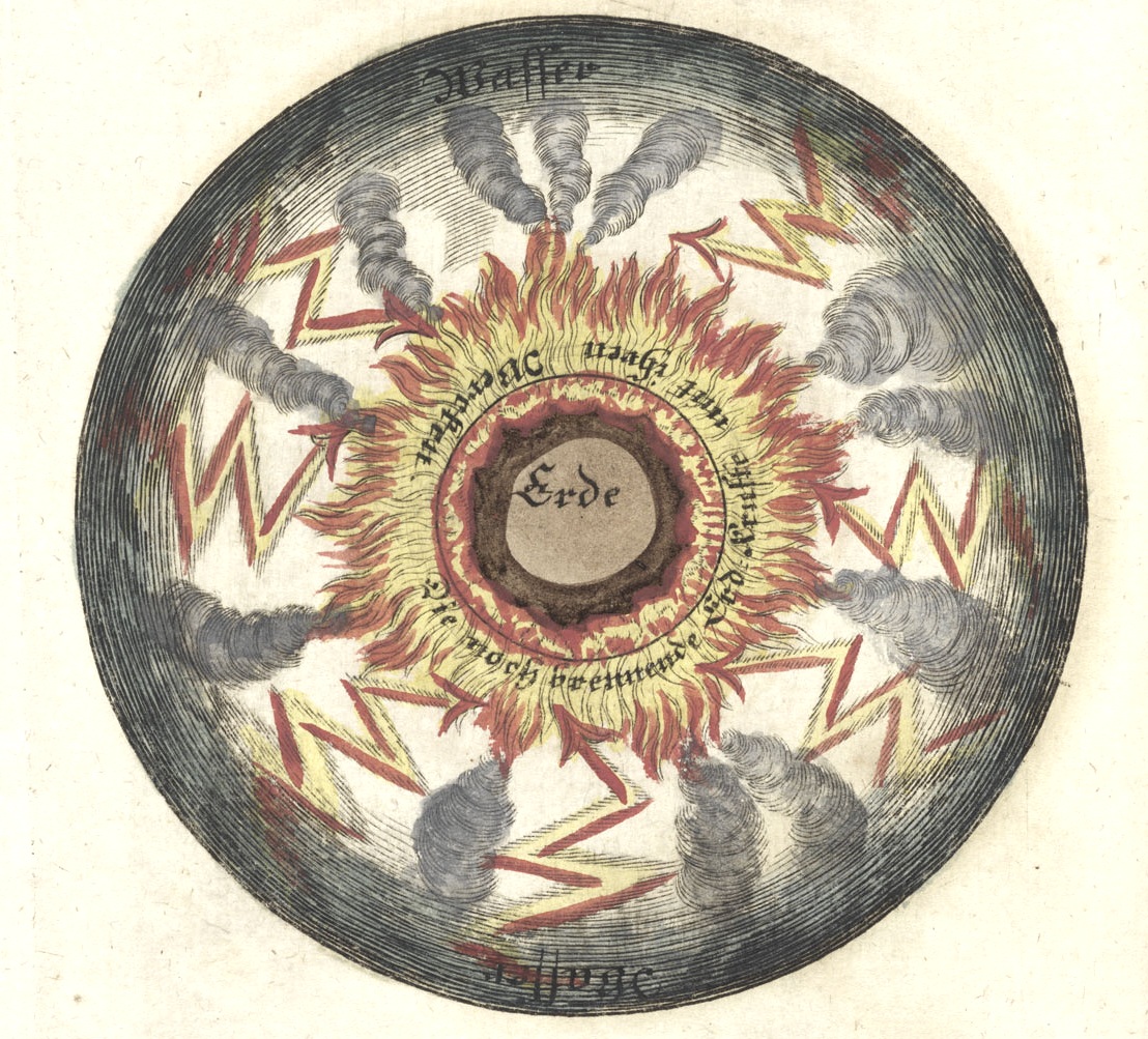
    There appeared earlier in this blog a bit on an engraving depicting an exploding Earth, one of a series of twelve images, eleven of which were unavailable at that time–not so anymore.  So an update to this post is happily made, starting with the exploding part (below), a nasty millennial vision steeped in a volcanological/geological/meteorological 18th-century primordial stew, the Earth in a sea of fire and blasted volcanoes, lightning striking from above:

      Frisch 5
    [All image sources:    Herzogin Anna Amalia Bibliothek, Weimar.]

    Hades, Heaven, Meru, Valhalla, Elysium, Olympus–the places at the end of the terrestrial road, the great emancipation. In some theological doctrines these places are reached collectively after the great conflict at the end of time; the end of days in the Old Testament, when the earth is devoured by holy vengeful wrath and reconstituted for godly comings –and-goings.

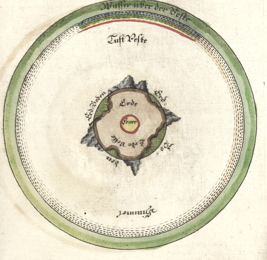
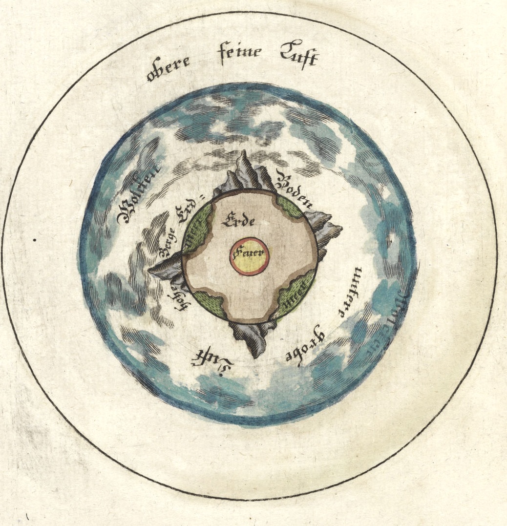
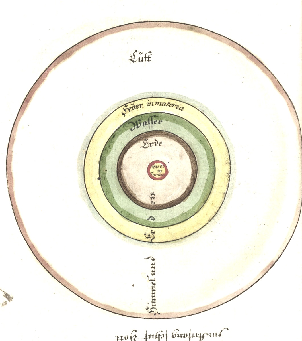
    This engraving is one of twelve found in a fine little book, the brainchild of clergyman/semi-scientist Jodocus Frisch (1714-1787), who delivered to the (un-) waiting world his vision of how the earth and heaven will come to an end, there at the end of days.   Die Welt im Feuer, Oder das Wahre Vergehen und Ende der Welt, Durch den letzten Sünd-Brand  (printed in Sorau by Gottlob Heboldm in 1746) is one of very few works that depict (in  illustration) the destruction of the Earth, and even though Frisch illuminates biblically-based theory, the idea of the earth exploding into bits in primordial fire and so on was extraordinary.  The images were done in four colors representing the four elements:  yellow, brown, green and white represented (respectively) fire, earth, water and air. In this image, we see the fire-centric earth encircled by a sphere of water, which is surrounded by a sphere of fire, which in turn is surrounded by a sphere of air,  with much bad stuff happening. 

    Not having the book in hand I’m relying on the  description of the Dutch bookseller Asher & Company, an old-line bookseller of very fine antiquarian works, which wrote the following descriptions of the other images in the book (and which appears for sale right now at their site):

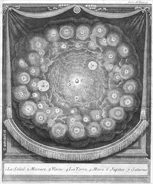
    “The second and third engravings show how the sphere of water disappeared after the torrential rains of the deluge, leaving the earth directly exposed to the sun. In the fourth and fifth engravings the earth is consumed by fire from within and without, demonstrating in what way the biblical prophecies about the destruction of heaven and earth may come to pass. Plates 6 and 7 depict the new heaven and earth that look entirely similar to plates 1 and 2, the first heaven and earth. Plates 8 and 9 show heaven and earth in their present state with precise specifications of what the biblical vocabulary names “heaven.” Plate 10 shows how the sphere of water breaks the rays of the sun in such a way that they shine on all parts of our planet in equal manner, wherefore all regions have a temperate climate. However without the tempering function of the sphere of water, the air focuses the rays of the sun in the equatorial zone.”

      Frisch 1 page 26

    The water of the great deluge now gone, revealing the land masses, plate 2:

    Frisch 2
     And so again, in plate 3:

    Frisch 3


  • Remaking Chicago, 1945–a Map of the Future

    JF Ptak Science Books   Post 1435

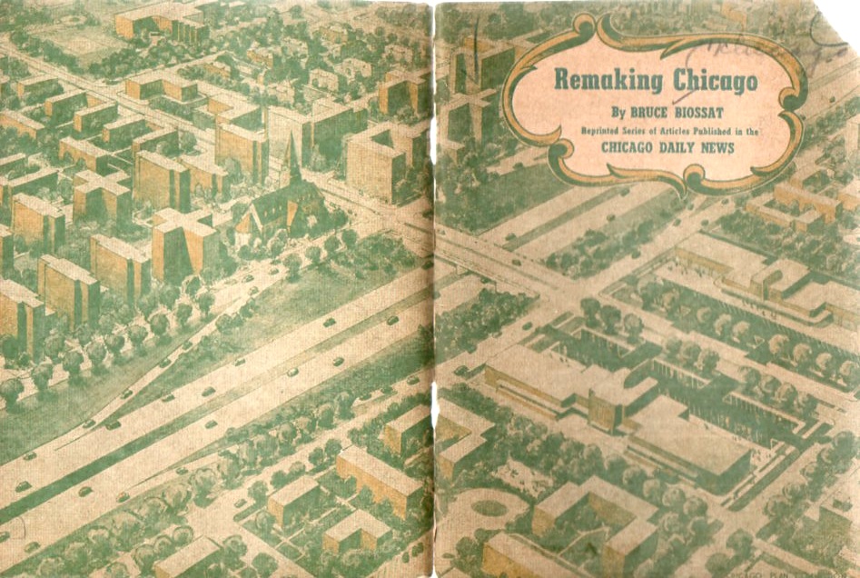
    Earlier today a post appeared here on re-envisioning the “one city” megalopolis of San Diego–Los Angeles–San Francisco by hoisting 2-acre neighborhoods into the sky to support some 5 million people or so.  Bruce Biossat, a writer for the Chicago Daily News, also had an ambitious plan for the city of Chicago, though in the face of putting thousands of acres of neighborhoods (with years) into massive highrises, Mr. Boissat’s plan–while massive–is not nearly so as the L.A. scheme.

    Chicago devel367

    For reasons I cannot determine, this small pamphlet1 (available at our blog bookstore) seems to be nowhere–no mention on the web, nothing in city planning databases, nothing in WorldCat (an actually nothing at all in this massive database about Mr. Biossat).  It was a massive undertaking, part of a project of the Chicago Plan Commission, and sought to relieve “blighted” areas from the city by replacing them with new housing and neighborhood design. This was part of a larger construction scheme nationwide:

        “The goal most mentioned as the desired postwar level of home construction is 1,000,000 units a year.  Both major labor organizations call for higher objectives, with the A.F.L. demanding 1,500,000 and the C.I.O urging 1,750,000 annually.”

    That is a lot of building, and I have no doubt that the ALF/CIO would’ve been behind a spending/earning opportunity like this 100%.  I’m not sure where all of this money was coming from, though I guess there would’ve been enough workers to handle the job.

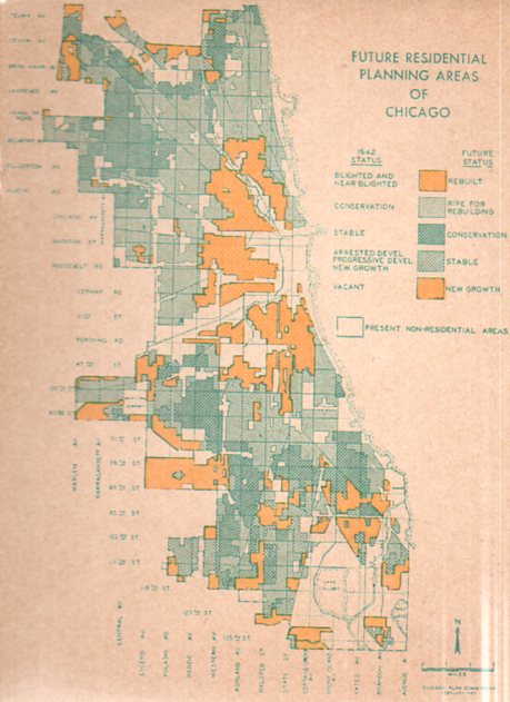
    Chicago devel366

    In any event, the plan was massive, as we can see in the map above–perhaps the designers/developers felt the end of the war coming, the return of millions of soldiers, and an opportunity to make some major changes in the development of the future of Chicago. 


  • Maps of Things Not There: Eden.

    JF Ptak Science Books  Post 1431

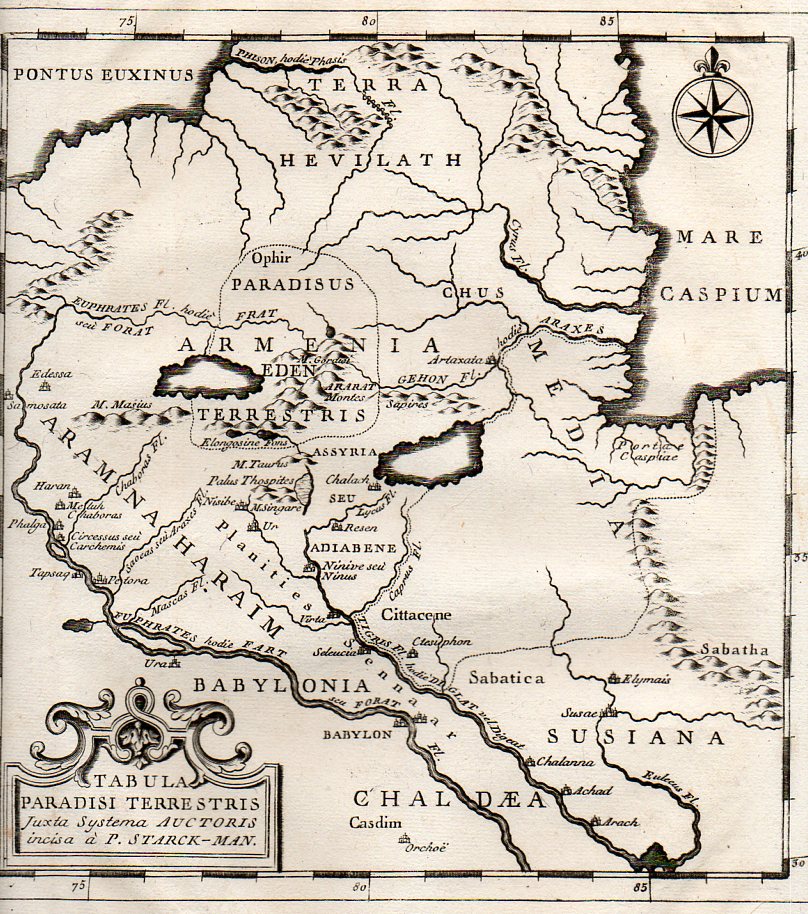
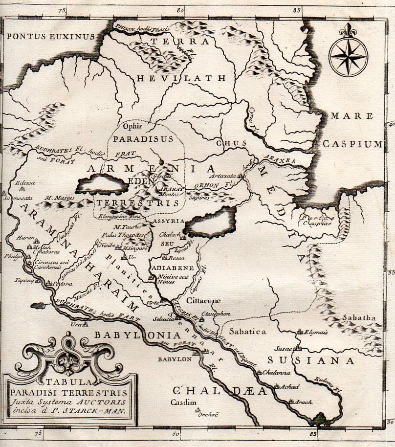
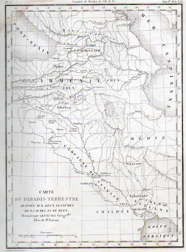
    The tale of the Garden of Eden is told in the Old Testament, and although it described, its location is left to mystery1, even though its legend is ground zero for the Fall of Man, the eternal disgrace for which humanity still pays. I suppose it would be nice to have a tombstone for the grave. Over time—and particularly in the Middle Ages and then in the Renaissance—the location was fixed in the eastern reaches of the known Euro-world, and then in and about Mesopotamia.

    Eden 2359

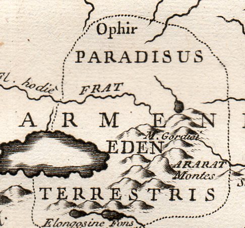
     The map Tabula Paradisi Terrestris justa Systema Auctoris incisa a P. Stark-Man was printed late in the 18th century, probably around 1775, and locates the GOE far in the north country, near the Dead Sea, deep in old Armenia, near Mount Ararat (where Noe and his family were supposed to have landed after the creator flooded the world killing everything, where everything else, young and old, infant younger, men women children, beasts and ants, were killed by a wrathful OT maker.).  

    Eden 2358

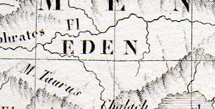
    The very finely engraved map by A.R. Fremin, Carte du Paradis Terrestre, printed 1839 (in Paris, by Félix Locquin et Cie, for  l’Atlas de la Sainte Bible)., again locates the Garden much further north than the great majority of other maps that I have seen, coming  (as with the map above) nearly to the Dead Sea.

    Linoleum italian274

    This image is a detail from:

    Linoleum italian273


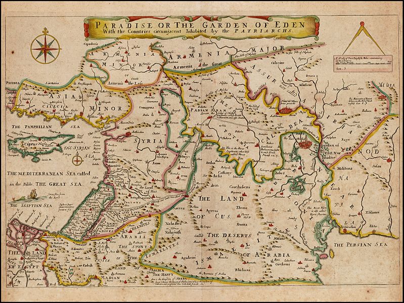
    Joseph Moxon’s Paradise of the Garden of Eden with the Countries circumjacent inhabited by the Patriarchs, printed in 1690,  shows the GOE as just to the east of Babel and not far due north from the Persian Gulf, just on the Euphrates in the Land of Nod, which is quite different from our two samples above. 

    Garden of eden Moxon

    [Source–https://commons.wikimedia.org/wiki/File:Paradise_or_the_Garden_of_Eden_With_the_Countries_circumjacent_Inhabited_by_the_Patriarchs,_Joseph_Moxon_1660.jpg]
     
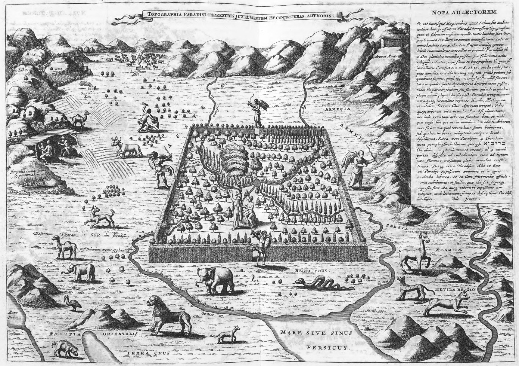
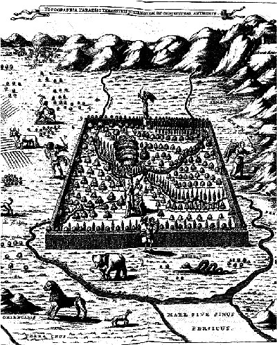
    The polymathic and semi-problematical Jesuit genius Athanasius Kircher suspected the location of Eden to be along the Tigris and Euphrates Rivers, in southern Iraq, and published his idea in this map Topographia Paradisi Terrestris in his book Arca Noe in 1665. It is of course a highly idealized map, Eden taking up a disproportionate amount of land, larger than life, bigger than legend almost, a monstrous overstatement of the lost land. Eden is shown here with four gates guarded by angels, but it does its occupants little good, as we can see that Adam and Eve are already stepping up to Satan in the tree of knowledge, and that outside Cain is killing Abel, all harm already being done.

    Garden of Eden Kircher

    [Source: the website The City as a Project, here: http://thecityasaproject.org/2011/07/paradise/]


    There continue to be differences of opinion on this matter of location, particularly in the modern age, when there are many laying claim to the position of Eden, including a number of half-hearted attempts to locate the place or its idea/ideal in the United States.  There are at least 14 Edens in the U.S.– Eden  City/Isle/Town/Valley/Prairie/Village/–in twelve different states (Idaho, Louisiana, Maryland, Minnesota, Mississippi, New York, North Carolina, South Dakota, Texas, Wisconsin, Wyoming and thankfully Hawaii),but for some reason they are fairly sparely populated, eight of them having populations of under 1000 people.  I don’t know what that means.

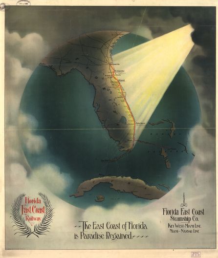
    Then there is this terrific example, coming from Florida (which does not seem to actually have anyplace in the state named Eden), in 1898, being a transorbital bird’s-eye view of the east coast of Florida receiving  pure holy light, announcing yet another newish Eden.

    Paradise florida

    [Image source: Library of Congress, Geography and Map Division.]

    Notes

    1. “And a river went out of Eden to water the garden; and from thence it was parted, and became into four heads. The name of the first is Pison: that is it which compasseth the whole land of Havilah, where there is gold; And the gold of that land is good: there is bdellium and the onyx stone. And the name of the second river is Gihon: the same is it that compasseth the whole land of Ethiopia. And the name of the third river is Hiddekel: that is it which goeth toward the east of Assyria. And the fourth river is Euphrates.” (Genesis 2:10-14 KJV)

  • Geronimo, Finally Defeated by Miles and the Sun

    JF Ptak Science Books  Post 1355

    The Chiricahuan Apache leader and chief, Geronimo (1829-1909), famously led a progressively diminishing band  through the  Apache Wars of the 1850’s-1880’s.  For thirty years of so he quirted the U.S. Cavalry, darting here and there in great exploits and famous escapes, evading the armies of the United States and Mexico.  In the end, by 1886, there were just dozens who were following him, including women and children, and the elderly, ragged, tired, hungry, and pretty much, finally, beaten.

    I think what finally did Geronimo in were the miles of pursuit and the sun. 

    The sun got to him via the heliographic communication network established by Major W.J. Volkman under the direction of General Nelson Miles (the other “miles” of this equation of defeat), which allowed the pursuing American army to communicate instantaneously over great distances, over hundreds of miles, without the need for runners or men or horseback or cutable telegraph wires or time  The heliograph is an ancient instrument, used for more than two thousand years–in this case, they were very highly polished mirrors that reflected brilliant signals between stations, getting their light source from the sun. It allowed the army an enormous advantage, and one that finally caught up to Geronimo.

    The “miles” were just those, the thousands of miles Geronimo was tracked and retracked over that very difficult terrain in the southeastern part of Arizona and into northern Mexico, sharp mountains, endless badlands, caves, heat, height, cold….very difficult. (I’ve been there on treks.. .its tough land.)


    The capitalized “Miles” was the surname of General Nelson A. Miles who sent out  with Lt. Col. George F. Crook to track down and capture Geronimo–and they almost did, again, in late MArch, 1886, when Geronimo presumably surrendered, but then fled to Mexico. After another five months and 1,600 miles, Miles came upon Geronimo om in Sonoran mountain camp, and induced him for the final time in September, 1886, at Skeleton Canyon, Arizona.

    The details of the capture and surrender are told in many places by many others–I just wanted to surface the role of the sun in the capture of Geronimo.

    The old man (who lived until 1909 and outlived just about everybody involved with hunting him down except for General Miles, who died in 1925) was shipped east,  never to see Arizona again. He died after being thrown from his horse and contracting pneumonia as a result of being unable to help himself to safety through a long cold night, died in a bed as a prisoner in Ft. Sill, Oklahoma.

    [The original map is available from our blog bookstore.]


  • SuperBad Ideas: Superhighway Through the Center of Washington D.C., ca. 1925

    JF Ptak Science Books  Post 1346    

    “A Paved United States in Our Day”

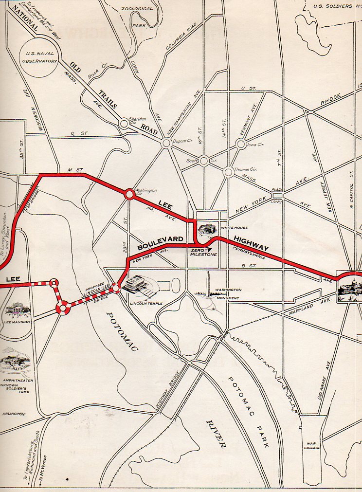
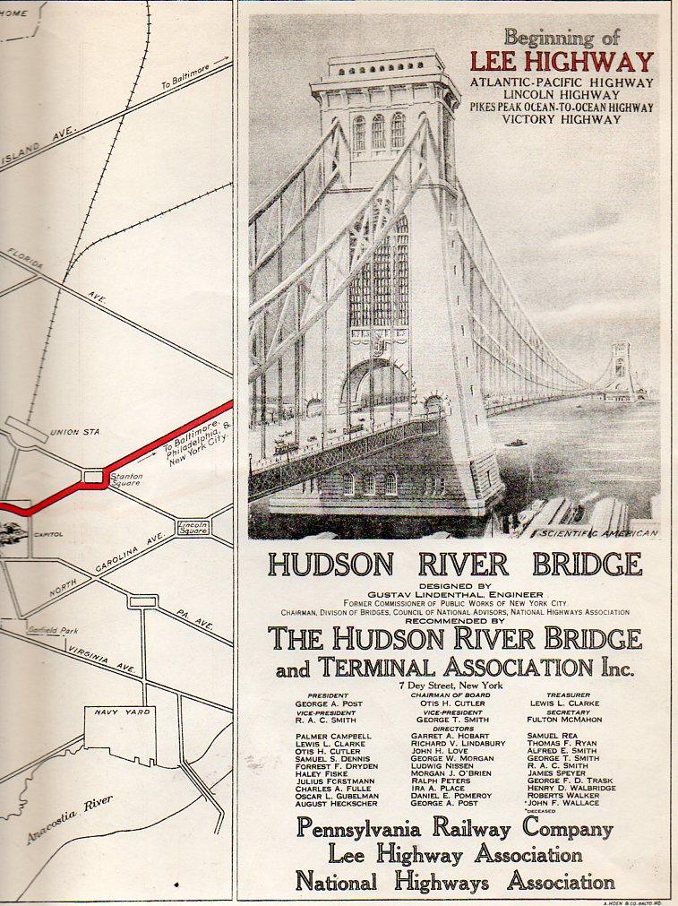
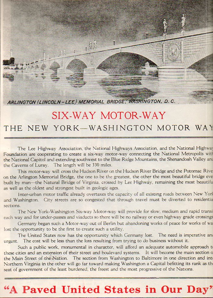
    If the planners of this highway had a crystal ball to see deep into the future–say, 1955–they would have been horrified to see the errors in their ways.  The equivalent of this plan might be something like picking up the Beltway, straightening it out, and running it  through D.C. along 16th street, with massive flyovers for the White House and other associated et ceteras.  This idea was published in an odd source, published by the Pennsylvania Railway Company/Lee Highway Association/National Highway Association auspices and the Hudson River Bridge and Terminal Association in about 1925, or thereabouts, just prior to the construction of the George Washington Bridge in NYC.  

    Lee Highway443 Lee Highway444


    The plan was for a six lane (“six-way”) motorway from New  York to Washington, starting with the Lee Highway (or King’s Highway, Route 1, one of the south’s oldest roads, and part of what was supposed to be a national autotrail connecting New York with San Francisco) and taking that highway across the proposed Arlington Bridge (called Lincoln-Lee here, without irony), up New York Avenue to the ellipse, rounding the White House, going down Pennsylvania Avenue to the Capitol, and then out again to Baltimore and NYC.  Another version called for the highway to go across Key Bridge, dumping everything in Georgetown, hooking right on M Street to Pennsylvania and on out again.  Having lived in D.C.(with my store in Georgetown) for 29 years, I can say without fear of ____  that this would ave been a massively bad idea then and in every decade since then, and probably would have been removed by 1960 just to recognize and correct the sheer, overwhelming badness of its conception. (The original of this map is available for purchase from our blog bookstore.)

    Lee Highway445
     The Memorial Bridge wound up being pretty close to this design–lacking the statuary, especially–and is quite a beautiful thing, especially when the designs for its rivals were considered.  The bridges in DC are almost all lovely, or at least those built before 1950. 


  • Great Maps Department: Nationalities of Manhattan, 1894.

    JF Ptak Science Books    Post 1343

    In the history of attractive and useful displays of quantitative data, the effort of Frederick Erastus Pierce (1878-1935), the creator of  The Tenement-House Committee Maps–with two maps on one sheet, showing the densities of Manhattan populations (on top) and the distribution of nationalities (at bottom)  and which was published in Harper’s Weekly for 18941–is an iconic example. [Please note–I am offering an original of this map for sale on this blog’s bookstore, though the images I’ve used for the post here are those for the copy at the Library of Congress.  My copy is actually a little nicer than these; I’ve used the LC images because the  map is just too big for the scanner.] 

    Text on verso:

    There’s a significant amount of crowded, complex information exhibited here, some somewhat more successfully than others.  The population density map is pretty straightforward.  The distribution of nationalities, however, is another story–there are eleven groups followed here, each given a bit of a confusing flavor, given that the representations are done in black-and-white.  Its difficult data to present, especially considering that the groups shown could vary block-to-block, and that the population of Manhattan at the 1890 showed 76% with foreign-born mothers and 40+% of the city foreign-born themselves.  (It should be noted that only the groups with 2/3 of the base of any particular zone has bene plotted.)

    Detail of bottom map:

    Much of this population–a good chunk of the city’s 1.9 million people–were housed in tenements, a pre-high-rise pre-elevator version of the highrise.  They were six or seven story walk-up buildings that were narrow (usually about 25-35 wide) and long (100-125+ as an average). There were 10-14 rooms per floor, and were generally packed with families.  A massive expose on the tenement house was photographically depicted in “The Tenement House Exhibition of 1899”, the un-pretty picture described below by Lawrence Veiller in Charities Review  in 1901: 

    “It has shown, step by step, the different changes that have taken place in New York tenement houses, and by means of 1,000 photographs has illustrated nearly all the evils of the present tenement-house system. Special emphasis has been laid upon the terrible evils of the dark, unventilated airshafts, which are the chief characteristic of the present type of buildings. There are over forty-four thousand tenement houses in the boroughs of Manhattan and the Bronx, and in the year 1899 about two thousand new tenement houses were erected. These, as a rule, are built on lots twenty-five feet wide by one hundred feet deep, and are planned to accommodate four families on a floor. The buildings are six or seven stories high, and each floor generally contains fourteen different rooms.”

    “Only four of these rooms on each floor have direct light and air from the street or the small yard. The other ten open on a narrow “air-shaft,”which is a well hole closed at both ends, seldom more than five feet wide, when between two buildings, and often only two feet six inches wide, varying in length from forty to sixty feet, and being generally from sixty to seventy-two feet high.”

    “The first of the accompanying illustrations represent a typical airshaft. As usual, it is closed at both ends. It is two feet ten inches wide, forty-eight feet long, and seventy-two feet high. Forty-two windows open upon it, the sole source of light and air to the rooms. Rents in this building run from$10 a month for three rooms to $17 for four rooms. The baby’s bathtub is hung out of the window because the rooms are so small that there is no place to keep it inside. The shaft is only a little wider than the tub.”–Charities Review, 10 (1900-1901), 19-25.

    Mr. Pierce did a commendable job in exhibiting some difficult quantitative stats in a fairly restrictive medium. 

    Notes:

    1.  The map[ sections are entitled: No. 1. Map of City of New York showing densities of population in the several sanitary districts, June 1, 1894 . And No. 2. Map of City of New York showing the distribution of Principal nationalities by sanitary districts.  On verso: text, two smaller maps “Map of the of City of New York”, showing density of population by wards, and then an unrelated but interesting  A bird’s-eye view of the Cotton States and International Exposition, Atlanta, Georgia; image of C.A. Collier, President and Director-General of the International Cotton State Exposition.  2 maps : on 1 sheet ; 14 x 48 cm. and 17 x 48 cm.