A Daily History of Holes, Dots, Lines, Science, History, Math, Physics, Art, the Unintentional Absurd, Architecture, Maps, Data Visualization, Blank and Missing Things, and so on. |1.6 million words, 7500 images, 4.9 million hits| Press & appearances in The Times, Le Figaro, Mensa, The Economist, The Guardian, Discovery News, Slate, Le Monde, Sci American Blogs, Le Pont, and many other places… 5000+ total posts since 2008.

Category: Maps/Diagrams of Imagination & Ideas

  • On Missing Antique Atlases of Imaginary Places and the Sameness of Alien Math and Music: Huygens’ 1698 ETs

    JF Ptak Science Books    Post 1458  [With thanks to Rich Lewis, Dickinson College, who found and suggested some remarkable cartographical curiosities!

    I was thinking about the history of atlases of imaginary places [in Western culture] composed before, say, 1900, and I had a hard time coming away with any.  Lowering the sites to a series of maps relating to the same idea didn’t help–its only when you get down to the single-map level that I found some results.  But even there, at the basic representational level of an imaginary place, there aren’t really that many examples, at least compared to the rich narrative life of created space.

    I wonder why that is? 

    If you widened the scope a bit you might look at the night sky as being a sort-of map locating ancient deities, but the sky is really just a picture book with dislocated images without very much to do with one another. 

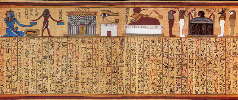
    Books of the Dead1 kind of fit the bill, but how come there aren’t any surviving ancient maps of Olympus, or
    Bookofthedeadspell17
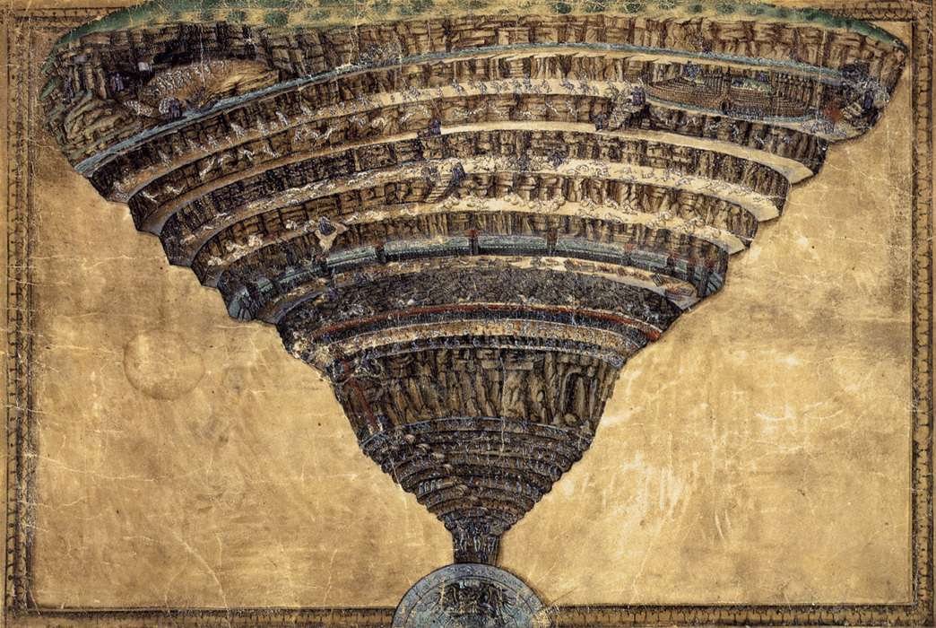
    Heaven for that matter?   The Heaven, and Hell, and Purgatory part does get mapped and mapped pretty heavily after Dante reaches the scene–there are at the very least dozens of cartographic/pictographic representations of the worlds that he surveyed in the Divine Comedy.  For example, there is this spectacular effort by Sandro Botticelli (being a drawing on parchment executed ca. 1480-1495):
    Hell_its_representation_through_the_ages

    The Botticelli is a scary accomplishment, frightening and heavy–you can almost feel the very burden of Hell coming down upon you. (Here’s a good link for a zoomifying version of this map so that you can see its elements in detail.)

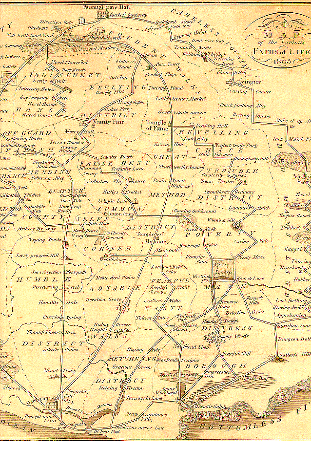
    Then there are allegorical maps that show the stages and stations of life, the progress of the arts and sciences.  A fine example here is a work by B. Johnson, who in 1805 published this fantastic map of the possible paths for living one’s life:
       Maps of Imagination
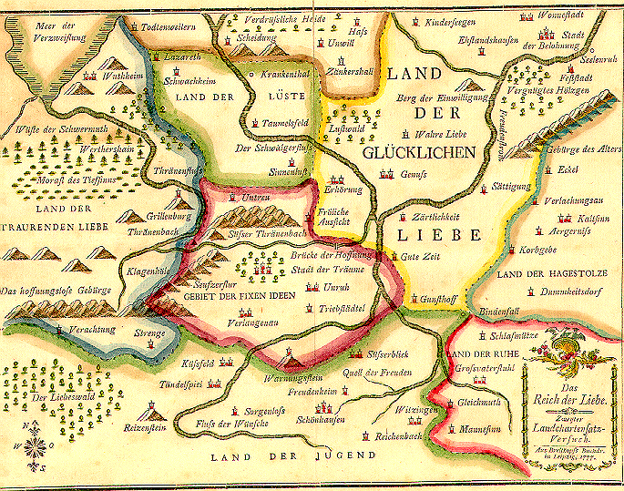
    which seems to tell the reader to keep away from the southeast. Another  map, this one earlier, printed in 1777, is by J.G.I. Breitkopf, Das Reich der Liebe (The Kingdom of Love):
    Maps of the imagination--
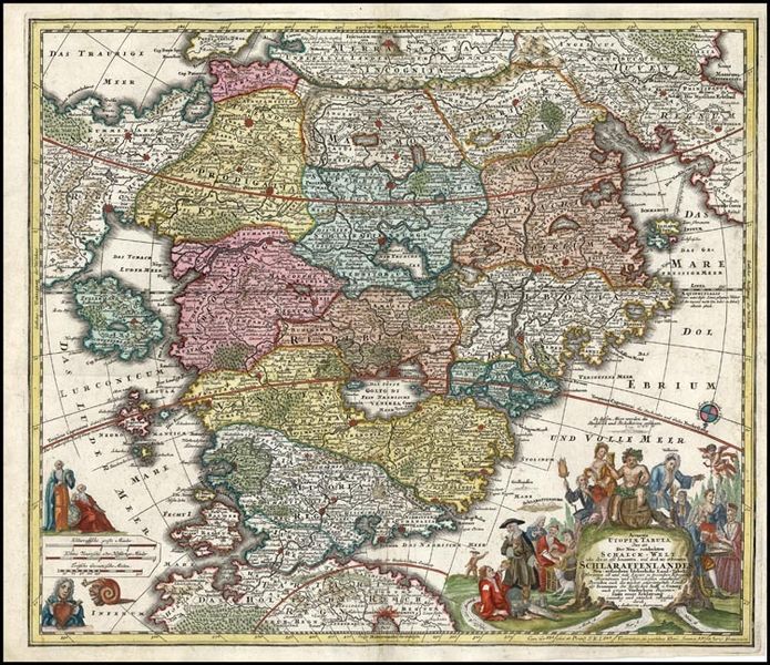
     Another fantastic example of mapping the imagination is found in Matthaus Seutter’s Accurata Utopiae Tabula. Das ist Der Neu entdeckten Schalck Welt, oder des so oft benannten und doch nie erkannten Schlarraffenlandes, published in 1730.  It depicts a Utopia of sorts, though not the world of Thomas More–this is like a pyrite of utopias, a fool’s gold, a fools’ paradise:
    Maps of imagination  utopia

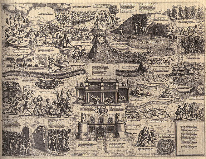
    This land is much like the land of Cockaigne, a mythical Medieval/Renaissance place of plenty, which is pictured below in an image made by Niccolop Nelli in 1564:
    Cockaigne1
    (It is interesting to picture these places of plenty and sloth in conjunction with some 20th century songs of the Great Depression and earlier, where the land of plenty is far, far simpler–as in the land of the Big Rock Candy Mountain–but that is a different story.)


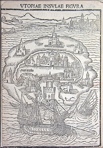
    As long as we’re mentioning Utopia, here’s a 1516 representation of More’s hopefullness, from the first edition of his work:
    Maps imagniation More's utopia 1515

    And another represntation, two years later:
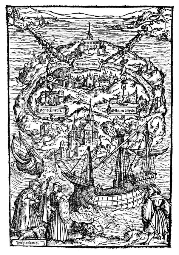
    Maps Imagination more's utopia

    There are more recent examples, but not that many, not so far, anyway.  There are editions of Pilgrims Progress (1678) that contain maps of the travels; there are also a number of charts showing the progress of Mr. Gulliver from the Swift book (1726);  Robinson Crusoe also contains a small sketch map opposite the title-page, and, more recently, R.L. Stevenson’s Treaure Island (1882) contains a map of that place.

    But given the extraordinarily rich tapestries of mythical/mystical places that have been created since the beginning of people telling stories, why weren’t there, well, tapestries (or something) illustrating what the whole of these places looked like?  Why for sample when we meet up with a map of the very pronounced extra-terrestrial wanderings of Cyrano de Bergerac (in his ancient-advanced science fiction work on traveling to other inhabited worlds)?  Taking the antiquarian thought on extra-terrestrials as a case study, why don’t we see more of that sort of thinking illustrated in some way?  The idea of extraterrestrial life is very old, stretching far back into Hindu cosmology, and even deep into the (eighteen worlds) of the Talmud.  Thales, Anaximander, Democritus, Aristole, Ptolemy all thought about and agreed on the possibilities of life being lived on places other than the Earth–infintely more life, in the case of Epicurus. Bruno, Copernicus, Fontenelle, Henry More–were all there, but without visual aids, and certainly without maps.  Except for Fontenelle–Bernard le Bovier de Fontenelle–who almost but not quite gets there in his 1682 book Entretriens sur la pluralite des mondes.
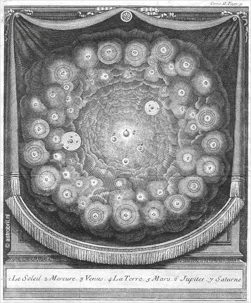
    Blog--plurality of world fontenelle :  

    It seems to me that as a representative of extraterrestrial imagination not being illustrated its hard to beat the case of the beautiful and polymathic Christian Huygens.  Huygens (1629-1685) worked across many fields, including astronomy, biology, math and physics, and was extraordinarily productive, making numerous contributions in the physical and theoretical areas, as well as being a prolific author and correspondant.  But towards the end of his relatively short life (he died at age 56) Huygens embarked down the science fiction road in pre-science fiction days, writing a wonderful and provocative book entitled Cosmotheoros, The Celestial World Discover’d: or, Conjectures Concerning the Inhabitants, Plants and Productions of the Worlds in the Planets3, where he establishes the possibilities of life being lived on worlds other than that of Earth. He developes a detailed fabric for these new heavens,m so much so that he can also establish samenesses for the ETs and humans, stating here his belief in the eternal/cosmoloigcal abilities of mathematics and music:

    “It’s the same with Musick as with Geometry, it’s every where immutably the same, and always will be so. For all Harmony consists in Concord, and Concord is all the World over fixt according to the same invariable measure and proportion. So that in all Nations the difference and distance of Notes is the same, whether they be in a continued gradual progression, or the voice makes skips over one to the next. Nay very credible Authors report, that there’s a sort of Bird in America, that can plainly sing in order six musical Notes: whence it follows that the Laws of Musick are unchangeably fix’d by Nature, and therefore the same Reason holds valid for their Musick, as we even now proposed for their Geometry”pg 86

    Huygens holds close to the immutable nature and close association of music and mathematics,m which would be the same here and everywhere (everywhere else, the ET communities, being referred to here as “other Nations”). 

    “For why, supposing other Nations and Creatures, endued with Reason and Sense as well as we, should not they reap the Pleasures arising from these Senses as well as we too? I don’t know what effect this Argument, from the immutable nature of these   Arts, may have upon the Minds of others; I think it no inconsiderable or contemptible one, but of as great Strength as that which I made use of above to prove that the Planetarians had the sense of Seeing.” pg 86/7

    Huygens is so sure of this that he is willing to tak a bet with long odds that not only do ETs enjoy the possibilities of muic but that they have also created instruments:

    “But if they take delight in Harmony, ’tis twenty to one but that they have invented musical Instruments. For, if nothing else, they could scarce help lighting upon some or other by chance; the sound of a tight String, the noise of the Winds, or the whistling of Reeds, might have given them the hint. From these small beginnings they perhaps, as well as we, have advanced by degrees to the use of the Lute, Harp, Flute, and many string’d Instruments. But altho the Tones are certain and determinate, yet we find among different Nations a quite different manner and rule for Singing; as formerly among the Dorians, Phrygians, and Lydians, and in our time among the French, Italians, and Persians” pg 87

    Huygens then continues to make a beautiful distinction between the musics of Earthling and ETs, in that it may not sound anything like any music we have on Earth, but–since the laws that govern math and music are the same, everywhere–it still might be “very good”.  And not only that, the alien music might be better than our’s:

    In like manner it may so happen, that the Musick of the Inhabitants of the Planets may widely differ  from all these, and yet be very good. But why we should look upon their Musick to be worse than ours, there’s no reason can be given; neither can we well presume that they want the use of half-notes and quarter-notes, seeing the invention of half-notes is so obvious, and the use of ’em so agreeable to nature. Nay, to go a step farther, what if they should excel us in the Theory and practick part of Musick, and outdo us in Consorts of vocal and instrumental Musick, so artificially compos’d, that they shew their Skill by the mixtures of Discords and Concords? pg 88

    And so on.  But why I wonder with all of the great images painted for us in his text is there no venturing into a visual artform?  There’s enough information in the Huygens work to allow for a map, but then there are none, not even something along the images of de Bergerac, who was perhaps among the greatest visionary of techno-anthropormorphic human flight.  Before he was the object of Edmund Rostand’s 1897 play, de Bergerac was a massively creative author, producing, among other things, the book Histoire des Etats et Empires de la Lune (History of the States and Empires of the Moon, published posthumously in 1657), followed by Histoire des Etats et Empires du Soleil (History of the States and Empires of the Sun, again, published further and deeper into his life’s surrender, 1662), both eventually collected as L’Autre Monde (Other Worlds).  Bergerac introduces us, the humble reader, to one of the most important concepts in the history of literature–namely that we humans were not only not alone in the universe, but that we were not even the dominant culture, and indeed we were actually hated by some of the other more advanced species.

    The foundations for structuring a visual habitat for the ideas of Huygens are abundant, as you can see easily in the table of contents (which is like an annotated table of contetns for a modern book) as seen in footnote #4–the signs for a road map are there, mostly–there’s just no road, but there are plenty of suggestions for one.

    So I bring this part of this open discussion to a close—I do ask forgiveness here in the likely case that I’ve left out some obvious examples, this is a Thinking-Out-Loud piece which takes place in the cultures west of the Urals–thinking about where the maps and images weren’t.  Finding almost nothing when you think there’s nothing there is easy to do, especially when you can hold yourself to a porous definition of “nothing”–the next step is harder, finding out how close people came to making these maps, or diagrams, or images.  

    And having said this about finding nothing I cannot let this piece go without mentioning The World’s Most Beautiful Map:  Lewis Carroll’s map from The Hunting of the Snark, an Agony in Eight Fits, and occurs in the Bellman’s tale, starting the second fit. It begins:

    The Bellman himself they all praised to the skies-
    Such a carriage, such ease and such grace!
    Such solemnity too! One could see he was wise,
    The moment one look in his face!
    He had bought a large map representing the sea,
    Without the least vestige of land:
    And the crew were much pleased when the found it to be
    A map they could all understand.
    “What’s the good of Mercator’s North Poles and Equators,
    Tropics, Zones, and Meridian Lines?”
    So the Bellman would cry: and the crew would reply,
    “They are merely conventional signs!
    “Other maps are such shapes, with their islands and capes!
    But we’ve got our brave Captain to thank”
    (So the crew would protest) “that he’s bought us the best-
    A perfect and absolute blank!”
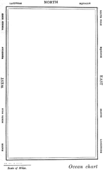
    Snarkmap

    Sometimes there is nothing so fine as something that beautifully illustrates the nothing that isn’t there, and this lovely map, unencumbered of all of the elements and details that define the mapness of something,  perfectly explains the origin of its need.

    Notes:

    1.  They’re not really the Book of the Dead, but collections of papyrus that each contain a unique set of instructions and magic spells and such to assist its dead reader of getting fromthe dead place into the light, into the afterlife.  This image is a rather famous one, pictured and described in the following Wiki bit:  “The mystical Spell 17, from the Papyrus of Ani. The vignette at the top illustrates, from left to right, the god Heh as a representation of the Sea; a gateway to the realm of Osiris; the Eye of Horus; the celestial cow Mehet-weret; and a human head rising from a coffin, guarded by the four Sons of Horus.“

    2.  Here’s another version of the Dante structures placed in context to the Earth, this image by A. Ritter. 

    3. Following the edition of 1698 translations appeared in English (1698) and in Dutch (1699). In the following years, translations also appeared in French (1702), German (1703), Russian (1717) and in Swedish (1774)
     
    4.  The table of contents (with links) is extremely interesting and tells much of the story of the book:

    Book 1

    • Some have already talk’d of the Inhabitants of the Planets, but went no fartherThe Objections of ignorant Cavillers prevented
    •   This Enquiry not overcurious
    • Conjectures not useless, because not certain
    • These Studies useful to Religion
    • Copernicus’s System explain’d
    • Arguments for the truth of it
    • The Proportion of the Magnitude of the Planets, in respect of one another, and the Sun
    • The Lamell more convenient than Micrometers
    • The Earth justly liken’d to the Planets, and the Planets to it
    • Arguments from their Similitude of no small weight
    • The Planets are solid, and not without Gravity
    • Have Animals and Plants
    • Not to be imagin’d too unlike ours
    • Planets have Water
    • But not just like ours
    • Plants grow and are nourish’d there as they are here
    • The same true of their Animals
    • Great variety of Animals in this Earth
    • And no less in the Planets
    • The same in Plants
    • Rational Animals in the Planets
    • Vices of Men no hindrance to their being the Glory of the Planet they inhabit
    • Reason not different from what ’tis here
    • They have Senses
    • Sight
    • Hearing
    • A Medium to convey Sound to the Ear
    • Touch
    • Smell and Tast
    • Their Senses not very different from ours
    • They have Pleasure arising from the Senses
    • All the Planets have Fire
    • The bigness of their Creatures not rightly guest at by the bigness of the Planets
    • In the Planets are many sorts of rational Creatures as well as here
    • Men chiefly differ from Beasts in the study of Nature
    • They have Astronomy
    • And all its subservient Arts
    • Geometry and Arithmetick
    • And Writing
    • And Opticks
    • These Sciences not contrary to Nature
    • They have Hands
    • And Feet
    • That they are upright
    • It follows not therefore that they have the same shape with us
    • A rational Soul may inhabit another Shape than ours
    • The Planetarians not less than we
    • They live in Society
    • They enjoy the pleasures of Society
    •    They have Houses to secure ’em from Weather
    • They have Navigation, and all Arts subservient
    • As Geometry
    • They have Musick
    • The Advantages we reap from Herbs and Animals
    • And from Metals
    • From the discoveries of our Age
    • The Planets have, tho not these same, yet as useful Inventions 

    Book 2

    • Kircher’s Journey in Ecstacy examin’d
    • The System of the Planets in Mercury
    • In VenusIn Mars
    •  Jupiter and Saturn the most eminent of the Planets both for bigness and attendants
    • The proportion of the Diameter of Jupiter, and of the Orbs of his Satellites, to the Orbit of the Moon round the Earth
    • The periods of Jupiter’s Moons
    • And Saturn’s
    • This proportion true according to all modern Observations
    • The apparent magnitude of the Sun in Jupiter, and a way of finding what light they there enjoy
    • And in Saturn
    • Always the same length
    • They see the fixt Stars just as we do
    • The appearances of the Ring in Saturn
    • Very little to be said of the Moon
    • The Guards of Jupiter and Saturn are of the same nature with our Moon
    • The Moon hath Mountains
    • But no Sea, nor Rivers, nor Clouds, nor Air and Water
    • The Conjecture of its Plants and Animals very dubious Jupiter’s and Saturn’s Moons turn always the same side to them
    • The Astronomy of the Inhabitants of the Moon
    • This may be applied to the Moons about Jupiter and Saturn
    • The immense distance between the Sun and Planets illustrated
    • No ground for Conjecture in the Sun
    • The Faculty in the Sun not easily seen
    • By reason of its Heat no Inhabitants like ours can live in the Sun
    • The fix’d Stars so many Suns
    • They are not all in the same Sphere
    • The Stars have Planets about them like our Sun
    • A way of making a probable guess at the distance of the Stars
    • Every Sun has a vortex round it, very different from those of Cartes 
     

    See: 

    “This Is Not a Map”, by Max Byrd, The Wilson Quarterly  Vol. 33, No. 3 (Summer, 2009) (pp. 26-32).

    John Pickles, A history of spaces: cartographic reason, mapping and the geo-coded world,  (London and New York, Routledge, 2004)

    Katharine Harmon, editor, You are here: personal geographies and other maps of the imagination. (New York, Princeton Architectural Press, 2004).

    Giuliana Bruno. Atlas of Emotion: Journeys in Art, Architecture, and Film (New York, Verso, 2002).

    Denis Wood, ‘Map art’, Cartographic perspectives 53 (2006), pp. 5–14: p. 11.
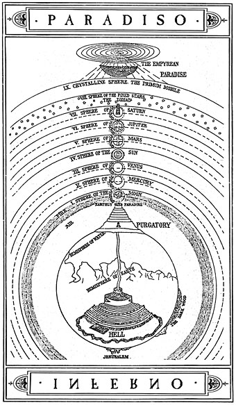

  • Strange Things in the Sky Dept.–Dante and Beatrice and the Vault of Stars

    JF Ptak Science Books    Post 1457

    There is a developing thread on this blog relating to strange things in the sky. Sometimes the images are extraordinary, impossible, beyond fiction:  multiple/duplicate Earths, flying buildings, horses in balloons, extra-human missing souls downloaded to the Earth from extra-Moons, and so on.  And at other times, the images are more subtle, questioning, ambiguous, as in the example of some 16th century prints that show the sky opening to reveal the Creator, who is in turn pictured against, say, a completely blank background, suggesting an enveloping nothingnesss of Heaven; or a field of beautiful stars filling a Renaissance sky of deepest red, at night.  A gigantic foot shown floating in the sky in a 17th century image might be ambiguous, and it also wildly so;  both it and the more subtle ambiguities–for example early representations of caves-over-mountains that give them an inside-out appearance–are welcomed sights.

    Perhaps some of the most beautiful of the Strange Things in the Sky department might belong to the skies of  Dante–they can be extraordinary, straightforwardly unusual and–when the narrative is presented pictorially–beautifully strange and with little ambiguity.  They are presentations of ideas of time and space, fantastic adventures in imaginary environments, as much an internal journey as Milton’s Paradise Lost is an external one1.

    Dante’s celestial exploration and the foundation that he provides have led to the possibility of an entire atlas of maps of paradise, hell and purgatory.  Here’s an interesting map2 constructed by Michelangelo Caetani (1804-1882) showing the structure of the Comnedia:

    Dante comedia
    I’ve presented this map just to give a context for the placement of the following images, though I do like the Caetani because it presents a good overview of the entire placement of Dante’s work, though necessarily having to leave out almost all of the detail of what is actually going on in each level. 

    Nearly all of the images below are from La comedia di Dante Aligieri con la nova espostione di Alessandro Vettlutello, published in Venice in 1544 by Francesco Marcolini (or Marcolino)3.  For the present collecting/browsing purposes I’m just going to go over the images lightly rather than try to launch into an ill-advised exegesis on a subject that I don’t know very well at all.

      Dante sun big
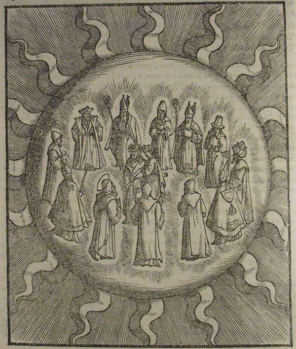
    In the Sphere of the Sun Dante and Beatrice among the wise and the learned, hearing them all (eleven) named so by Thomas Aquinas.  They include Albertus Magnus, Gratian, Peter Lombard, Solomon, Dionysius the Areopagite, Orosius, Boethius, Isidore of Seville, Bede, Richard of St. Victor, Siger of Brabant. Paradiso X

       Dante fixed stars
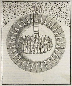
    Dante and Beatrice entering the sphere of the fixed stars, using a ladder of contemplation, mythically suggesting stairs and in this case a stairway to god. 

    Ante--empyrean

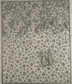
    The souls ascent to the Empyrean, with Dante looking down to see the Earth (“the little patch that makes us so vicious”), and to trace the (“mad”) voyage of Ulysses, and to see perhaps how far he has traveled (Paradiso XXVII).  Dante listens to St. Peter, and Beatrice, who describe the place, which is basically the mind of god and which is the envelope surrounding the final sphere:

             “The nature of the universe which holds
              The center still and whirls the spheres around it
              Takes from this region here its starting-point.
     
              “And here this heaven has no other where
              Than in God’s mind, where there flames up the love
              That spins it, and the power it pours down.
     
              “Light and love enclose it in one circle
              As it does all the rest, and this enclosing
              He alone who circles it can comprehend.

    Beatrice and Dante


    Beatrice and Dante together with Saint John and Saint James,  Paradiso XXV.

              “My body is still earth within the earth
              And will remain there with the rest until
              Our number equals the eternal tally.
     
              “Only those two lights who have ascended
              Wear their two robes here in the blessed cloister,
              And this word you shall bring back to your world.”
     

    Woodcut illustrating Paradiso II
    I couldn’t resist straying a bit to show this fantastic 1491 woodcut (published in Venice by Petrus de Plasiis) illustrating Dante and Beatrice surveying and then entering the Moon.  The scene is described in  Paradiso II:

              “Turned toward me, as glad as she was lovely,
              And said, “Direct your mind with thanks to God
             Who here has made us one with the first star.” –-[the Moon is described and identified as a star.]
     
              I thought we were enveloped in a cloud,
              Shining, solid, dense, and highly polished
              As a diamond struck by the sun would be.
     
              The timeless pearl took us inside itself
                In the same way that water can receive
              A ray of light while it remains intact”
    Again, my apologies to those among you who know Dante–I really was just trying to get at the luxuriant strangeness of these images and display them–much more so than talk about them. 

    Notes

    1. “The difference is that the visual phantasy bequeathed by Dante was mainly a congeries of intense and intricate symbolisms of his own personality,” Masson explains, “whereas that offered by Milton was mainly a sublime version of an independent objective tradition.” 12. David Masson, The Life ofJohn Milton: Narrated in Connexion with the Political, Ecclesiastical, and Literary History of His Time, vol. 6, 1660-1674 (1880; reprint, New York,
    1946), p. 522.

    2.  Michelangelo Caetani, La Materia della Divina Commedia di Dante Aligherie (1855).

    3..   Francesco Marcolini (or Marcolino), a typographer born in Forlì, also published the first book of cartomancy, or telling the telling of the future and fortune through the use of a deck of cards, in his 1540 Le sorti intitolate giardino d’i pensieri (“The oracle called garden of thoughts”).


  • Maps of Things Not There: Eden.

    JF Ptak Science Books  Post 1431

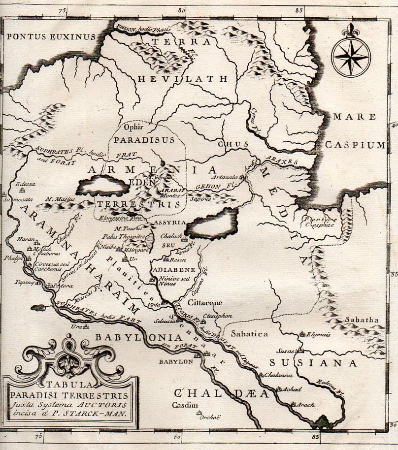
    The tale of the Garden of Eden is told in the Old Testament, and although it described, its location is left to mystery1, even though its legend is ground zero for the Fall of Man, the eternal disgrace for which humanity still pays. I suppose it would be nice to have a tombstone for the grave. Over time—and particularly in the Middle Ages and then in the Renaissance—the location was fixed in the eastern reaches of the known Euro-world, and then in and about Mesopotamia.

    Eden 2359

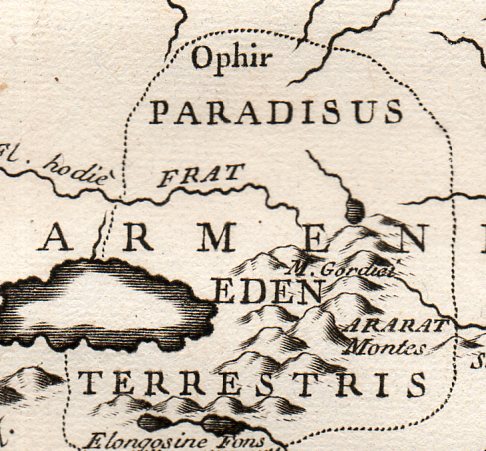
     The map Tabula Paradisi Terrestris justa Systema Auctoris incisa a P. Stark-Man was printed late in the 18th century, probably around 1775, and locates the GOE far in the north country, near the Dead Sea, deep in old Armenia, near Mount Ararat (where Noe and his family were supposed to have landed after the creator flooded the world killing everything, where everything else, young and old, infant younger, men women children, beasts and ants, were killed by a wrathful OT maker.).  

    Eden 2358

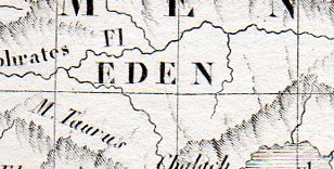
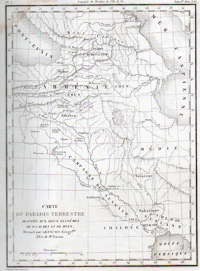
    The very finely engraved map by A.R. Fremin, Carte du Paradis Terrestre, printed 1839 (in Paris, by Félix Locquin et Cie, for  l’Atlas de la Sainte Bible)., again locates the Garden much further north than the great majority of other maps that I have seen, coming  (as with the map above) nearly to the Dead Sea.

    Linoleum italian274

    This image is a detail from:

    Linoleum italian273


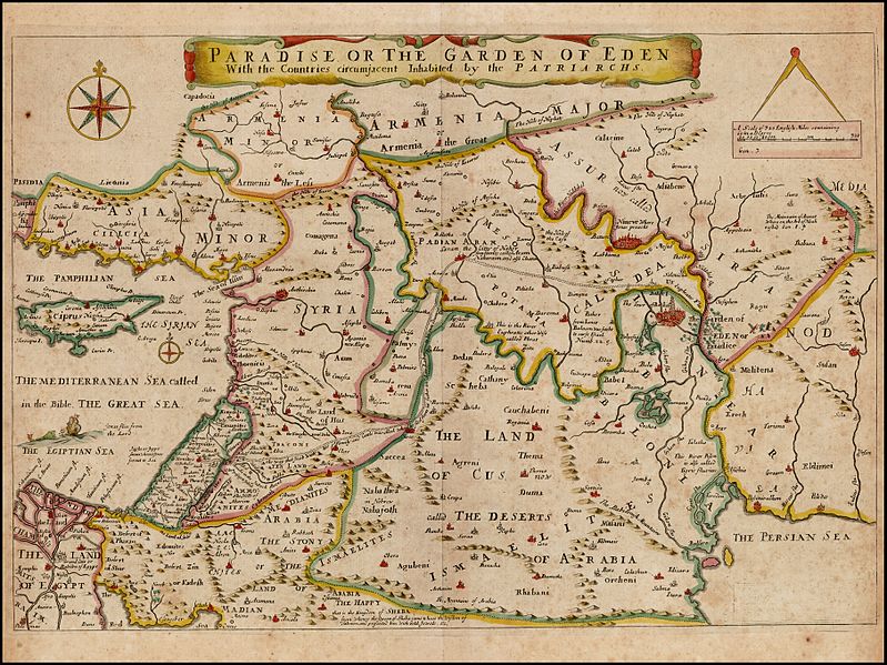
    Joseph Moxon’s Paradise of the Garden of Eden with the Countries circumjacent inhabited by the Patriarchs, printed in 1690,  shows the GOE as just to the east of Babel and not far due north from the Persian Gulf, just on the Euphrates in the Land of Nod, which is quite different from our two samples above. 

    Garden of eden Moxon

    [Source–https://commons.wikimedia.org/wiki/File:Paradise_or_the_Garden_of_Eden_With_the_Countries_circumjacent_Inhabited_by_the_Patriarchs,_Joseph_Moxon_1660.jpg]
     
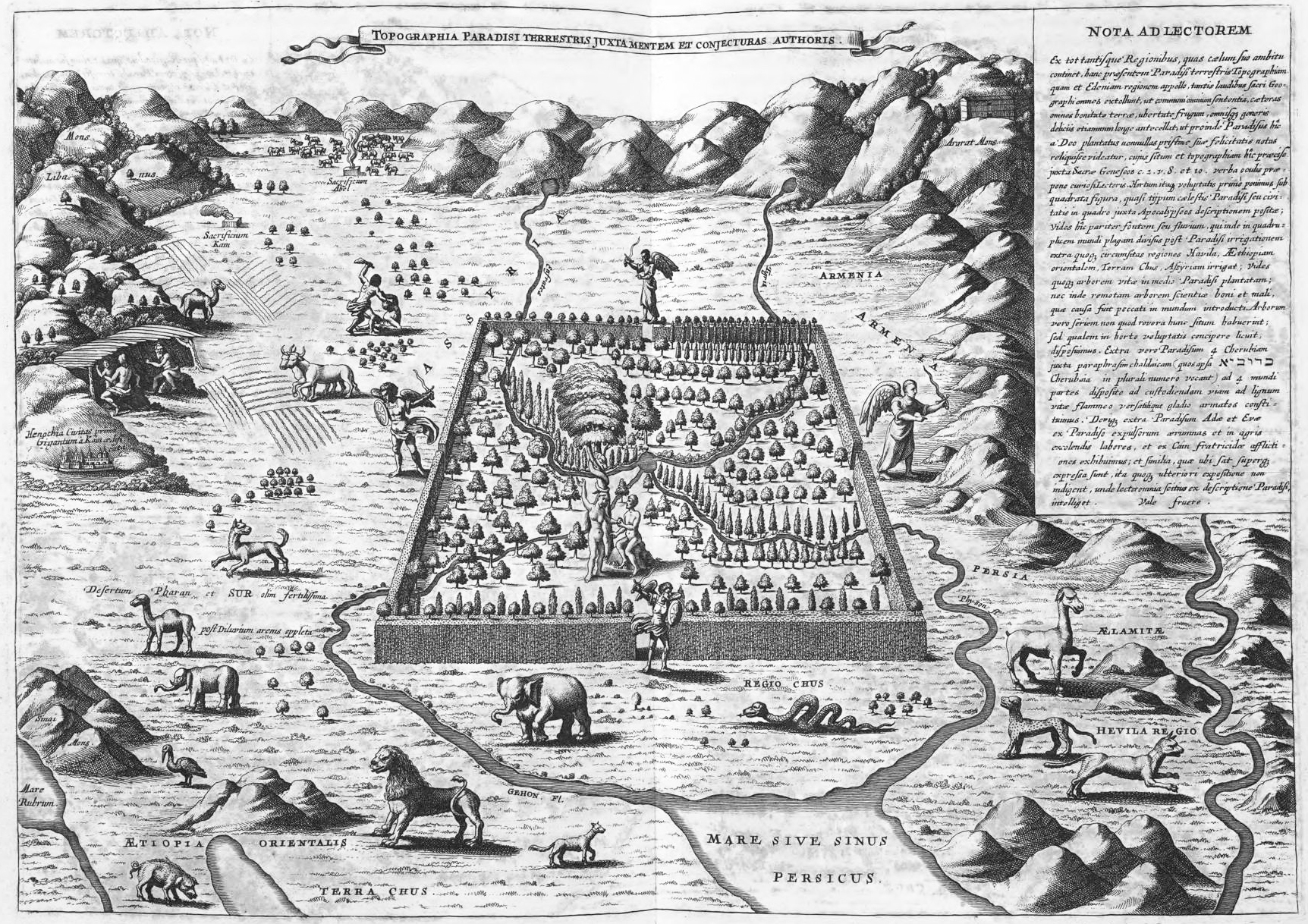
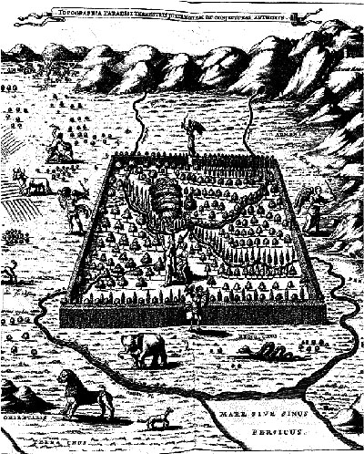
    The polymathic and semi-problematical Jesuit genius Athanasius Kircher suspected the location of Eden to be along the Tigris and Euphrates Rivers, in southern Iraq, and published his idea in this map Topographia Paradisi Terrestris in his book Arca Noe in 1665. It is of course a highly idealized map, Eden taking up a disproportionate amount of land, larger than life, bigger than legend almost, a monstrous overstatement of the lost land. Eden is shown here with four gates guarded by angels, but it does its occupants little good, as we can see that Adam and Eve are already stepping up to Satan in the tree of knowledge, and that outside Cain is killing Abel, all harm already being done.

    Garden of Eden Kircher

    [Source: the website The City as a Project, here: http://thecityasaproject.org/2011/07/paradise/]


    There continue to be differences of opinion on this matter of location, particularly in the modern age, when there are many laying claim to the position of Eden, including a number of half-hearted attempts to locate the place or its idea/ideal in the United States.  There are at least 14 Edens in the U.S.– Eden  City/Isle/Town/Valley/Prairie/Village/–in twelve different states (Idaho, Louisiana, Maryland, Minnesota, Mississippi, New York, North Carolina, South Dakota, Texas, Wisconsin, Wyoming and thankfully Hawaii),but for some reason they are fairly sparely populated, eight of them having populations of under 1000 people.  I don’t know what that means.

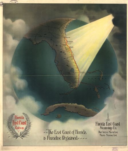
    Then there is this terrific example, coming from Florida (which does not seem to actually have anyplace in the state named Eden), in 1898, being a transorbital bird’s-eye view of the east coast of Florida receiving  pure holy light, announcing yet another newish Eden.

    Paradise florida

    [Image source: Library of Congress, Geography and Map Division.]

    Notes

    1. “And a river went out of Eden to water the garden; and from thence it was parted, and became into four heads. The name of the first is Pison: that is it which compasseth the whole land of Havilah, where there is gold; And the gold of that land is good: there is bdellium and the onyx stone. And the name of the second river is Gihon: the same is it that compasseth the whole land of Ethiopia. And the name of the third river is Hiddekel: that is it which goeth toward the east of Assyria. And the fourth river is Euphrates.” (Genesis 2:10-14 KJV)


  • SuperBad Ideas: Superhighway Through the Center of Washington D.C., ca. 1925

    JF Ptak Science Books  Post 1346    

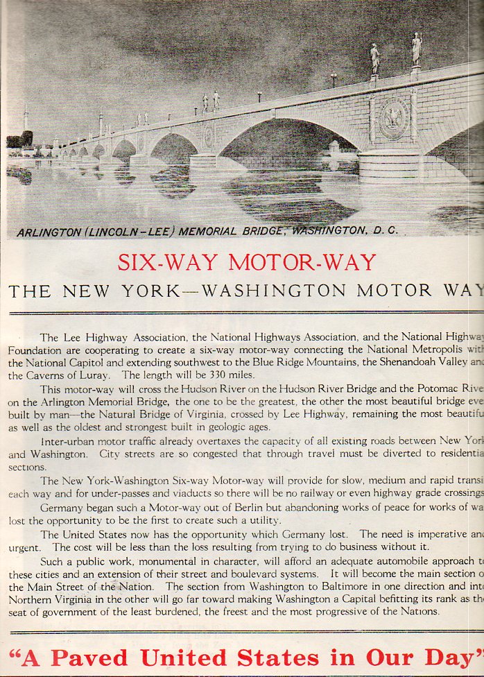
    “A Paved United States in Our Day”

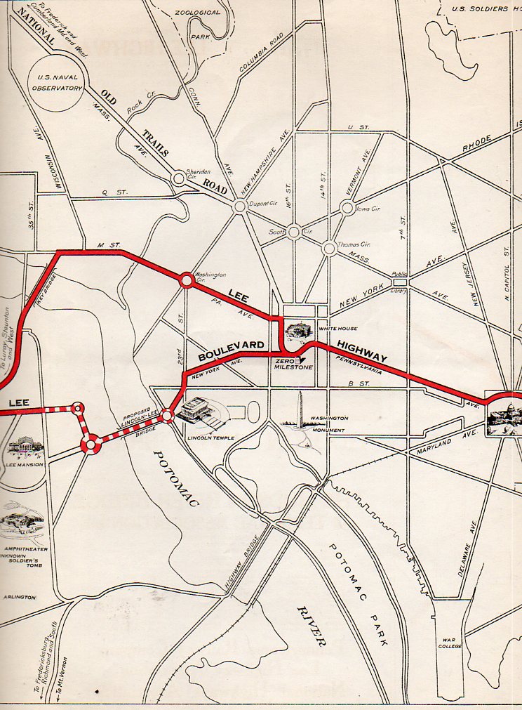
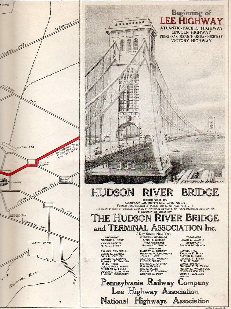
    If the planners of this highway had a crystal ball to see deep into the future–say, 1955–they would have been horrified to see the errors in their ways.  The equivalent of this plan might be something like picking up the Beltway, straightening it out, and running it  through D.C. along 16th street, with massive flyovers for the White House and other associated et ceteras.  This idea was published in an odd source, published by the Pennsylvania Railway Company/Lee Highway Association/National Highway Association auspices and the Hudson River Bridge and Terminal Association in about 1925, or thereabouts, just prior to the construction of the George Washington Bridge in NYC.  

    Lee Highway443 Lee Highway444


    The plan was for a six lane (“six-way”) motorway from New  York to Washington, starting with the Lee Highway (or King’s Highway, Route 1, one of the south’s oldest roads, and part of what was supposed to be a national autotrail connecting New York with San Francisco) and taking that highway across the proposed Arlington Bridge (called Lincoln-Lee here, without irony), up New York Avenue to the ellipse, rounding the White House, going down Pennsylvania Avenue to the Capitol, and then out again to Baltimore and NYC.  Another version called for the highway to go across Key Bridge, dumping everything in Georgetown, hooking right on M Street to Pennsylvania and on out again.  Having lived in D.C.(with my store in Georgetown) for 29 years, I can say without fear of ____  that this would ave been a massively bad idea then and in every decade since then, and probably would have been removed by 1960 just to recognize and correct the sheer, overwhelming badness of its conception. (The original of this map is available for purchase from our blog bookstore.)

    Lee Highway445
     The Memorial Bridge wound up being pretty close to this design–lacking the statuary, especially–and is quite a beautiful thing, especially when the designs for its rivals were considered.  The bridges in DC are almost all lovely, or at least those built before 1950. 


  • Great Maps Department: Nationalities of Manhattan, 1894.

    JF Ptak Science Books    Post 1343

    In the history of attractive and useful displays of quantitative data, the effort of Frederick Erastus Pierce (1878-1935), the creator of  The Tenement-House Committee Maps–with two maps on one sheet, showing the densities of Manhattan populations (on top) and the distribution of nationalities (at bottom)  and which was published in Harper’s Weekly for 18941–is an iconic example. [Please note–I am offering an original of this map for sale on this blog’s bookstore, though the images I’ve used for the post here are those for the copy at the Library of Congress.  My copy is actually a little nicer than these; I’ve used the LC images because the  map is just too big for the scanner.] 

    Text on verso:

    There’s a significant amount of crowded, complex information exhibited here, some somewhat more successfully than others.  The population density map is pretty straightforward.  The distribution of nationalities, however, is another story–there are eleven groups followed here, each given a bit of a confusing flavor, given that the representations are done in black-and-white.  Its difficult data to present, especially considering that the groups shown could vary block-to-block, and that the population of Manhattan at the 1890 showed 76% with foreign-born mothers and 40+% of the city foreign-born themselves.  (It should be noted that only the groups with 2/3 of the base of any particular zone has bene plotted.)

    Detail of bottom map:

    Much of this population–a good chunk of the city’s 1.9 million people–were housed in tenements, a pre-high-rise pre-elevator version of the highrise.  They were six or seven story walk-up buildings that were narrow (usually about 25-35 wide) and long (100-125+ as an average). There were 10-14 rooms per floor, and were generally packed with families.  A massive expose on the tenement house was photographically depicted in “The Tenement House Exhibition of 1899”, the un-pretty picture described below by Lawrence Veiller in Charities Review  in 1901: 

    “It has shown, step by step, the different changes that have taken place in New York tenement houses, and by means of 1,000 photographs has illustrated nearly all the evils of the present tenement-house system. Special emphasis has been laid upon the terrible evils of the dark, unventilated airshafts, which are the chief characteristic of the present type of buildings. There are over forty-four thousand tenement houses in the boroughs of Manhattan and the Bronx, and in the year 1899 about two thousand new tenement houses were erected. These, as a rule, are built on lots twenty-five feet wide by one hundred feet deep, and are planned to accommodate four families on a floor. The buildings are six or seven stories high, and each floor generally contains fourteen different rooms.”

    “Only four of these rooms on each floor have direct light and air from the street or the small yard. The other ten open on a narrow “air-shaft,”which is a well hole closed at both ends, seldom more than five feet wide, when between two buildings, and often only two feet six inches wide, varying in length from forty to sixty feet, and being generally from sixty to seventy-two feet high.”

    “The first of the accompanying illustrations represent a typical airshaft. As usual, it is closed at both ends. It is two feet ten inches wide, forty-eight feet long, and seventy-two feet high. Forty-two windows open upon it, the sole source of light and air to the rooms. Rents in this building run from$10 a month for three rooms to $17 for four rooms. The baby’s bathtub is hung out of the window because the rooms are so small that there is no place to keep it inside. The shaft is only a little wider than the tub.”–Charities Review, 10 (1900-1901), 19-25.

    Mr. Pierce did a commendable job in exhibiting some difficult quantitative stats in a fairly restrictive medium. 

    Notes:

    1.  The map[ sections are entitled: No. 1. Map of City of New York showing densities of population in the several sanitary districts, June 1, 1894 . And No. 2. Map of City of New York showing the distribution of Principal nationalities by sanitary districts.  On verso: text, two smaller maps “Map of the of City of New York”, showing density of population by wards, and then an unrelated but interesting  A bird’s-eye view of the Cotton States and International Exposition, Atlanta, Georgia; image of C.A. Collier, President and Director-General of the International Cotton State Exposition.  2 maps : on 1 sheet ; 14 x 48 cm. and 17 x 48 cm.


  • Map of Newsboy Work Violators, 1915–Child Labor & Child Scavengers

    JF Ptak Science Books   Post 1330 [Part of a developing series in the History of Normalcy]

    “There is work that profits children, and there is work that brings profit only to employers. The object of employing children is not to train them, but to get high profits from their work.” — Lewis Hine, 1908


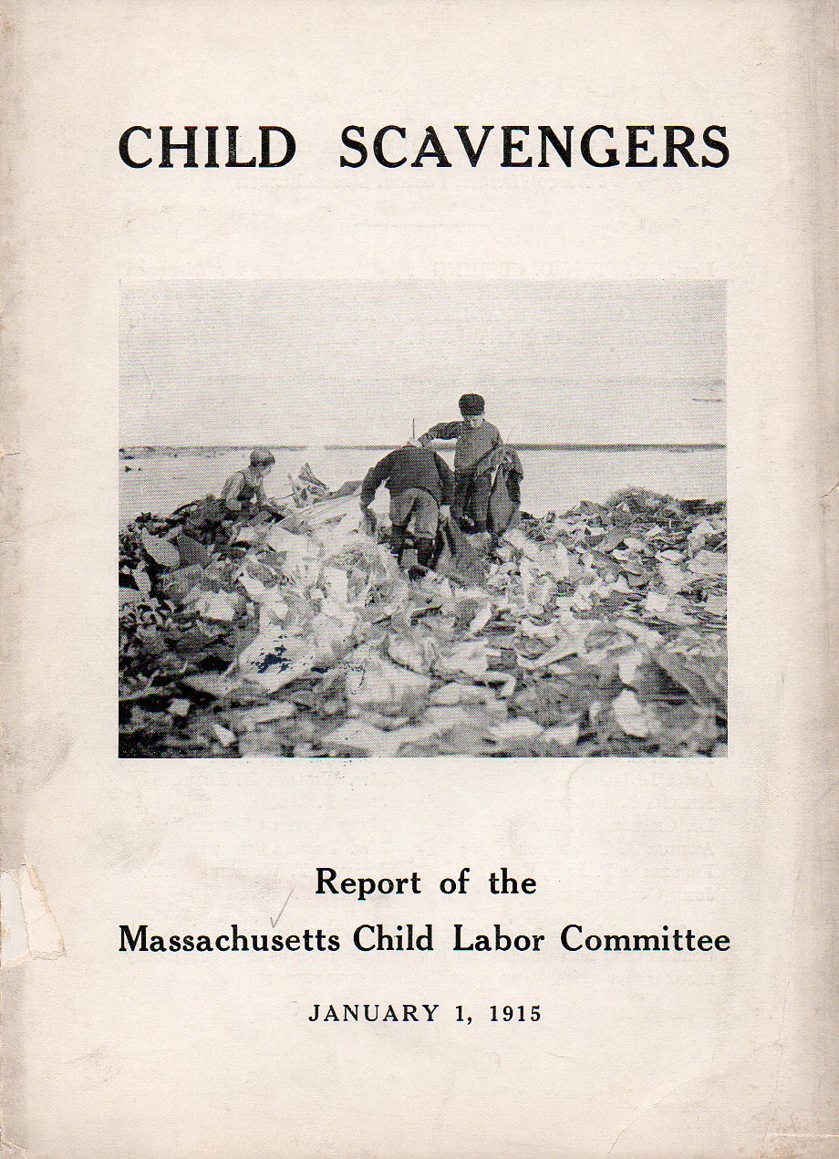
    As rudimentary as the title of this pamphlet seems, it isn’t really quite so, not really completely in the column of not having child laborers and exploiting children.  There is a degree of exploitation allowable–yes it was a different time–and the map that I’ve plucked from this work shows the extent of rough-edging of the law that was tolerated.  The authors weren’t so much concerned that there were 2500 newsboys in Boston-proper hawking newspapers morning/noon/night, but rather that they found over a third of them weren’t wearing their Newsboy Selling Badge when confronted.  And it wasn’t that they were under-aged–just that they were badgeless. 

    Child scavengers362

    On the other hand, the Massachusetts Child Labor Law Committee cited unidentified “critics” (and I don’t doubt that there were many) saying that “children don’t work enough nowadays, and that child labor laws have left nothing for children to do, especially in the cty where there are no chores”. (This work is available for purchase from our blog bookstore.)

    And they did do a study of child scavengers, reporting that in “one dump in a Massachusetts city fifty-five children from five to fourteen years old were moving slowly over an acre of rubbish…” The authors report (unfortunately without reference) that in one Boston school distict of 2,128 children that 125 of them “do this work”, and that 500 children in Boston “are so engaged”.  This didn’t include the children who “gathered refuse” from martketsm freight yards, and ash barrells”  or who were sent out collected odd bits of dropped wood and coal. 

    Child scavengers map363

    But the fact of the matter is that these folks were just knocking at the big door of child labor reform, a big piece of which would come into being in the next year (1916) with the Keating-Owens Act, which began the strict reulation of child labor, defining what the terms “labor” and “child” were. (The act restricted minig occupations to children 16 and over, and for 14 years of age for the manufacturing industries; no night work was any longer permitted, and the work day was limited to eight hours.  This was the reform, so one can imagine what the labor was like before this legislation.) In 1890 there were something like 1.5 million children in the workforce, a figure which was raised to 2 million by 1910, and which was nearly halved (because of awareness and federal oversight) by 1920.

    Lewis Hine (1874-1940)–who gives us the quote to lead this short post–was a school teacher and sociologist  who was extremely aware of the plight of the children around him–well, children, and immigrants, and laborers; people without voices, or representation, poor working people.  He was a pioneering photographer whose images of these classes of people were revoltuionary, a tremendously important documentarian of a societal symptom that was pretty much misdiagnosed, or at least was chosen as something to not be seen.  That was hard to do when you had actual photographs of the grim situaiton. 

    Trodd-lewis-hine-01

    This could’ve been my grandmother. At about this same time. 

    File:AddieCard05282vLewisHine.jpg

    Hine also made some of the most  iconic labor images in American history, a vastly underappreciated heroic figure duirng his lifetime.


  • Maps of Invasions of Great Britain and the United States

    JF Ptak Science Books  Post 1274–Real and Imagined

    America has almost never been invaded. I should clean that statement up a bit: the United States has almost never been invaded.  America–which included North/Central/South once upon a time long in the dim past–was constantly invaded until the invasions no longer counted themselves as such, which I guess means that the “invasion” forces became  “resupply”. (Perhaps an invasion is over once you surpass a certain ratio of houses : forts.)

    “Invasion” does not include “attacks”.  A few guys getting off a Nazi sub and wandering around until they got picked up (with some (all?) being executed) does not an invasion make.  9/11 was not an invasion, though the subsequent invention of impending and pervading fear was–that’s why we have “storm centers” rather than “weather reports” on broadcast news–but even that fear business was more home-grown than anything else.

    The Japanese Army were on two small islands in the Aleutian chain (which may have been closer to Tokyo than NYC) for a bit in WWII–also does not make for an invasion, even if they were there for a long time.  Or even if they were still there.  Nor does sending hundreds or thousands of paper incendiary balloons across the Pacific an invasion make. 

    UFOs don’t count, either.  (I still find it remarkable that such a large percentage of the hundreds of thousands of “sightings” has the UFO with landing or whatever lights on it. I figured out at one point that there has been a report on one of these critters every ____ minutes since Roswell. And in all of those hundreds of thousands or reports, if you took them all and stacked them one on top of the other, they would reach perhaps the height of a grain of sand.)  The Beatles don’t count, either.   

    What also doesn’t count (but probably should) but which is not military–not really, though it may have the impact of a military force at some time in the future–are Chinese-made imports of, well, everything.   At Thanksgiving I wondered how much of a dinner could be composed of foods that were shipped from China and to no great amazement an almost-complete table of food could be set, plus napkins, flatware, plates, candles, tablecloths, tables, chairs, paper turkey decorations, carpet, flooring, wallpaper, paint for the walls and ceiling, screws for the Chinese-made door hinges, lighbulbs, tubes for the McIntosh preamps, all of the clothing worn by the guests, and so on.  The electricity is still American-made. The fact that Mott’s Apple Juice is coming from Chinese apples is a bad sniff of the future. The country of origin is usually on juice bottle necks-check it out.)  

    Certainly something that does count is the invasion by Great Britain of the United States in the War of 1812–they invaded long and deep enough to burn the White House and cause general havoc.  We won that one.  But of course the Brits were otherwise involved on the Continent.

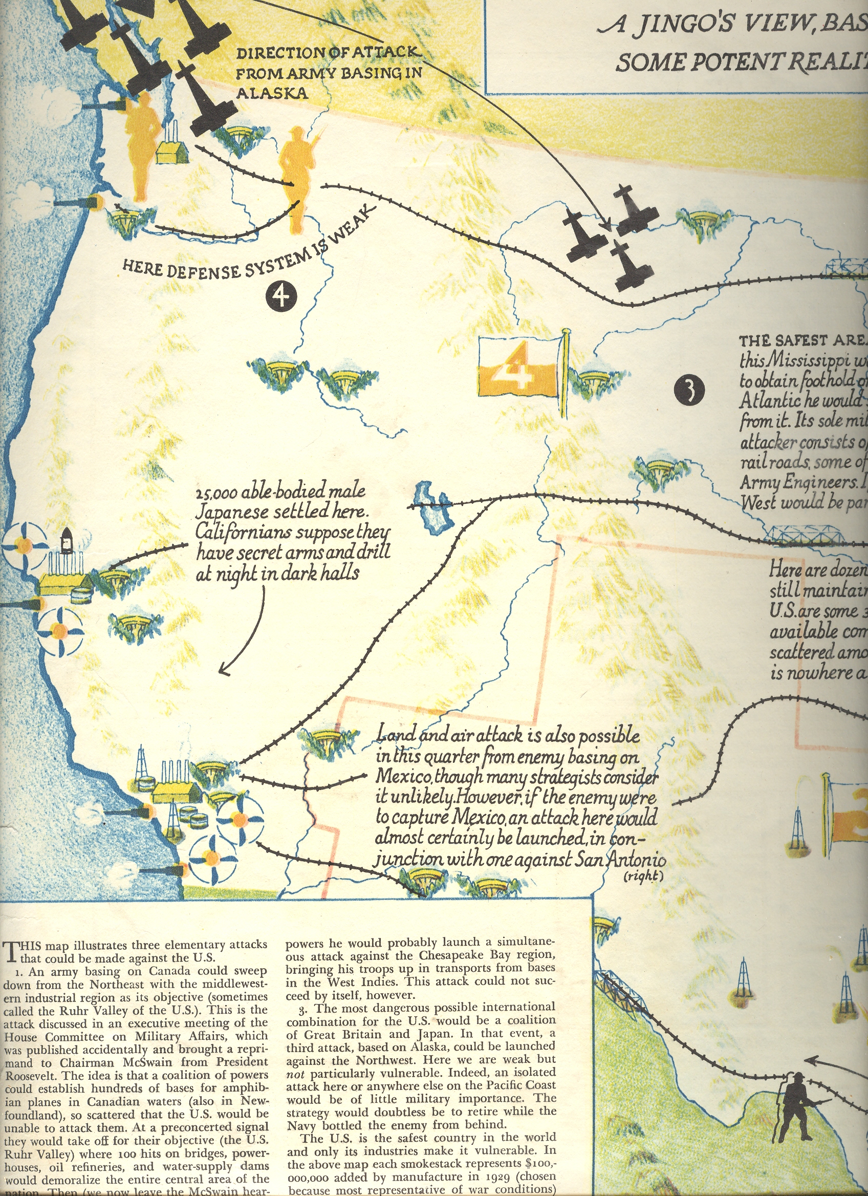
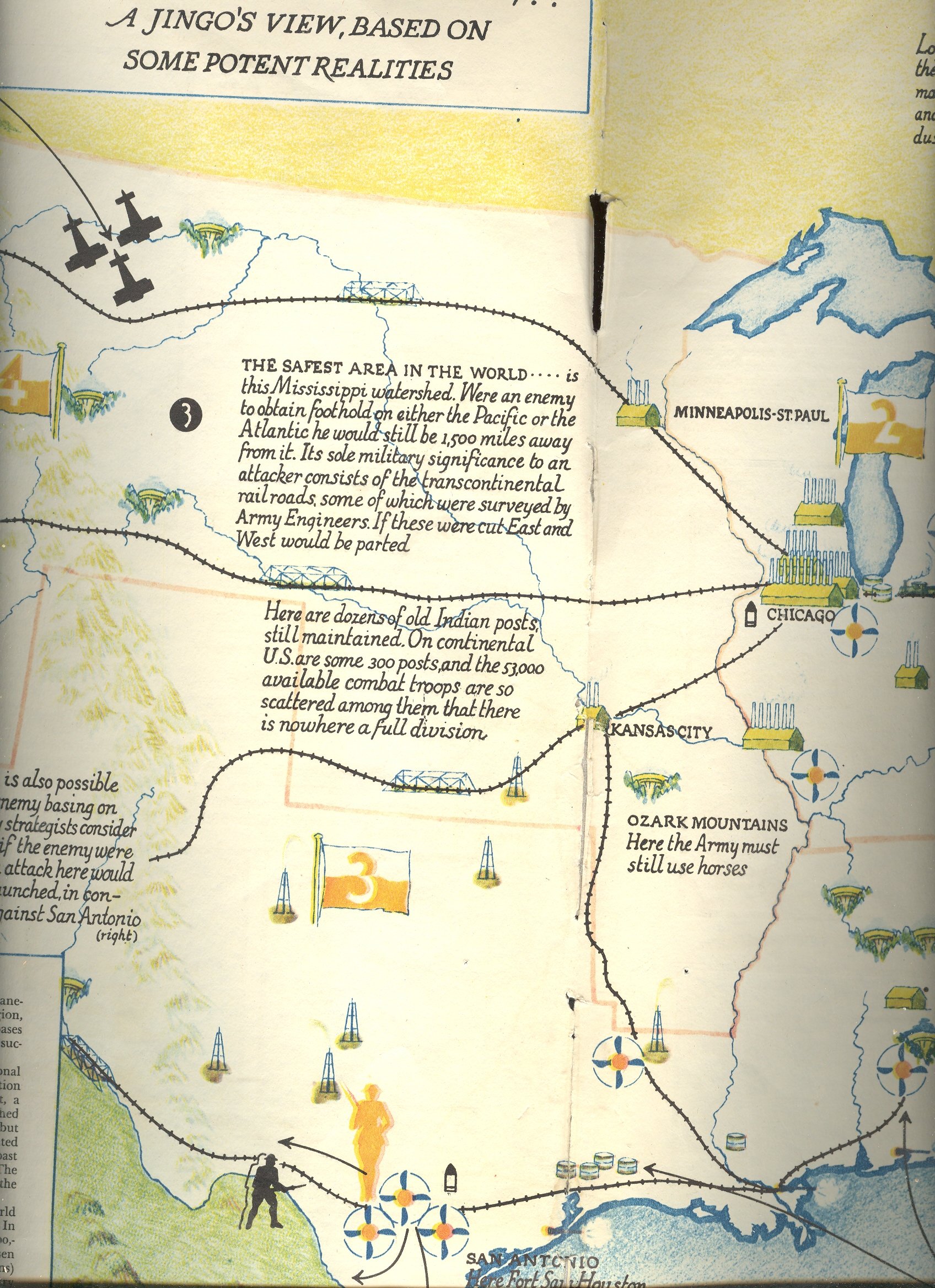
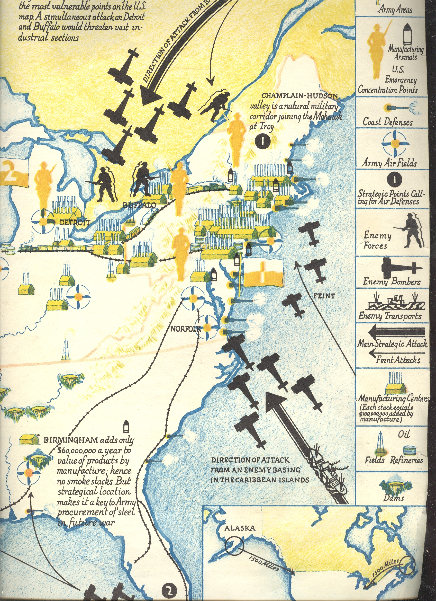
    Perhaps this non-invaded bit explains why the most-viewed post on this blog (with at last count was 400,000 views) was a LIFE magazine article from 1942 on the possible invasion routes to the U.S.  Maybe the volume was driven by war-gamers, though I suspect it was made up largely of the curious who weren’t used to seeing “Invasion of” and “America” together in a military sense.

    https://historyofideasblog.com/a/6a00d83542d51e69e20120a7a3225e970b-pi

    https://historyofideasblog.com/a/6a00d83542d51e69e2012876a5a4b4970c-pi

    https://historyofideasblog.com/a/6a00d83542d51e69e2012876a5a5e4970c-pi

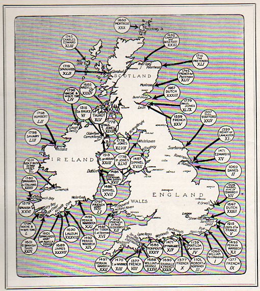
    But now for the  real stuff:  a map of the 54 invasions of Great Britain (and “the places at which foreign troops have landed on British soil since 1066 (and all that), seen in the Illustrated London News for 27 March 1909):

    Invasion--Us and England120

    And then this, where the WWII invasion routes were turned around: 

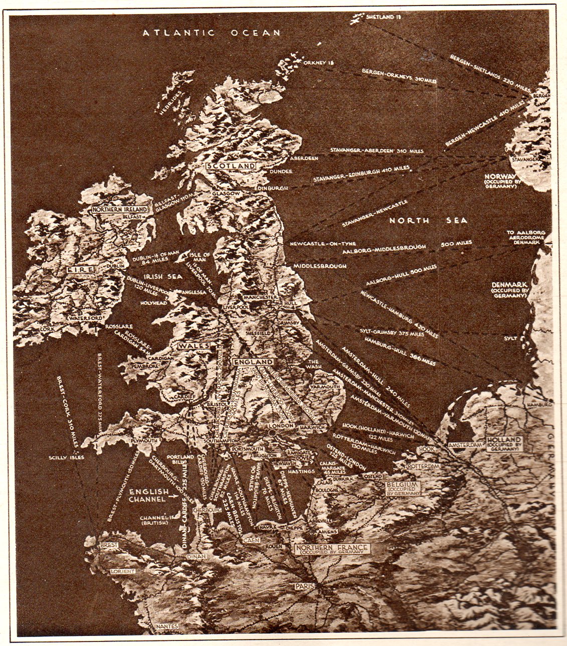
    Dunkerque124

    This map pretty well tells the story of the perilous situation of Europe and England at the beginning of June, 1940.  It appeared in the Illustrated London News on the heals of Churchill’s “Blood, Soil, Sweat and Tears” speech, and was a very frank presentation of the wearing of the war.  By this point in the war Nazi Germany had successfully invaded Belgium, France, Luxembourg and the Netherlands, sweeping across Europe in a broad westward movement, backing up British and French troops all the way to the sea at Dunkerque, where a monumental rescue operation (“Operation Dynamo”) saved them.  (There was an enormous amount of materiel left there on the beach, a devastating loss for the British Expeditionary Force, nearly crippling it.) This was a bad time for the Allies, this part of the war coined by Winston Churchill in 18 June 1940 in the House of Commons by:  “The Battle of France is over. I expect the Battle of Britain is about to begin”. There was very little good that came of these few months for the U.K and the Allies, though four things do stand out: (1) as I just mentioned, the saving of 300,000+ troops at Dunkerque; (2) the resignation of Neville Chamberlain, (3) the coming of Winston Churchill  as Prime Minister of the U.K., and (4) the first deciphering of the Enigma at Bletchley.  Other than that, the situation was dim, and these invasion routes (published at t he very time that Germany was studying such a feat in its “Operation Sea Lion“, or “Unternehmen Seelöwe”). The endgame at Dunkerque took place almost four years to the day of the invasion of Europe, when the intent (though not placement) all of these arrows were turned around for the Allied operation at the Normandy beaches on 6 June 1944..

    And so, there it is–a presentation of several maps showing invasions, real and imagined 


  • Reporting the Hiroshima Bomb the Day After, 7 August 1945. AND the First Graphic of NYC A-Bombed

    JF Ptak Science Books   Blog Bookstore  Post 1257 (continuing post 669)    Atomic and Nuclear Weapons Series

    ==Blog July 26=PM cvr bomb

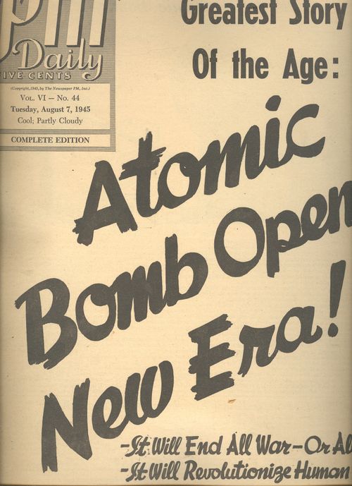
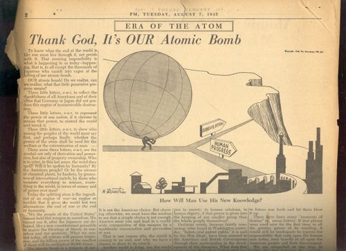
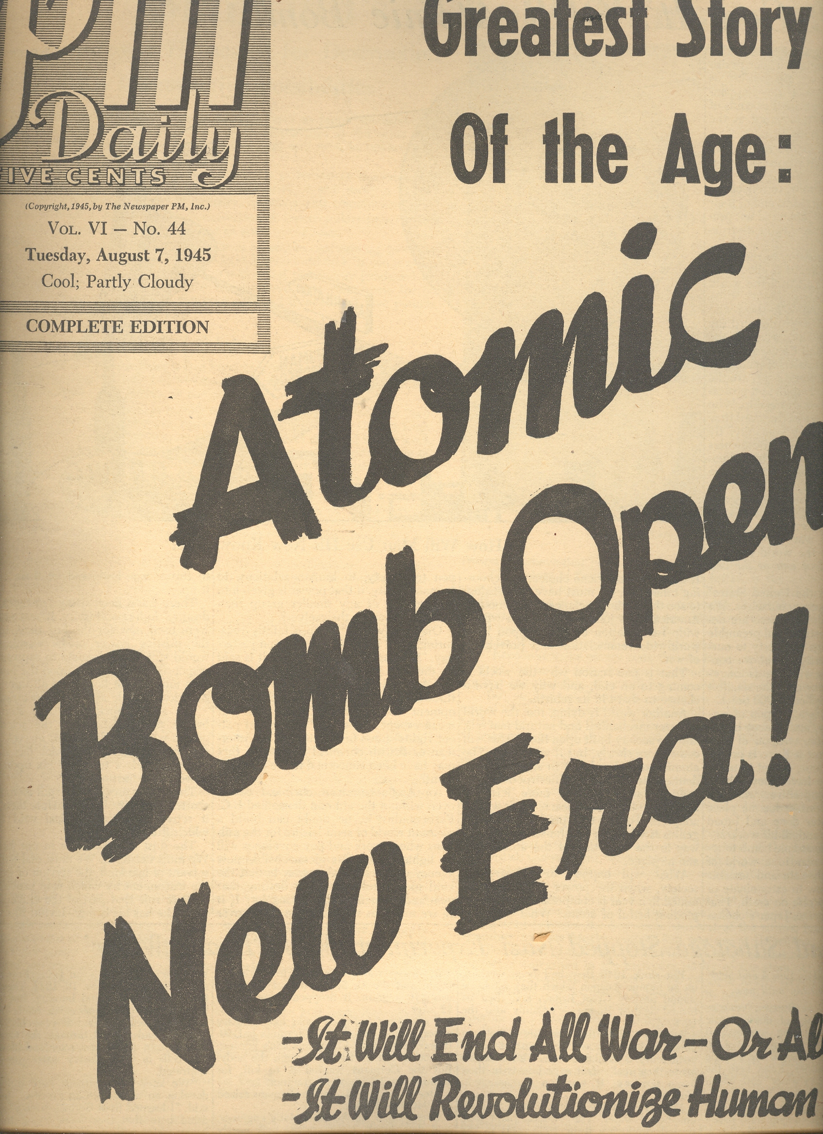
    The news coverage of the 6 August 1945 bombing of Hiroshima was covered in spectacular (all things and time considered) detail in the 7 August issue of the daily newspaper, PM.1  The entire issue of 12 pages (with no advertising2) was dedicated to the event—I have no idea, really, how they were able to put together this amount of good tough data so very quickly, nimbly and intelligently, as the bomb was detonated at Hiroshima only the day before. 

    It is odd how well the case is covered, and it is positively issued on the day after –it isn’t the case that it was issued for the week of 7 August and released on 13 August, which I thought was a possibility of explaining the deep coverage.  But there’s no mention of Nagasaki (which would come in two days), so I am certain that the coverage was all accomplished within 24 hours of the use of the weapon.  The newspaper distinguishes itself by not screaming something about the “Jap city” being wiped out (as so many other newspapers did), with its front page summarizing beyond the bomb.  (“It Will End all War—Or all Men” and “It Will Revolutionize Human Life” as sub-heads; the first being accurate, while the second being nearly so.) 

    The editorial, “Thank God its OUR Bomb”, by Irving Brant, is a lovely piece of thoughtful interpretation in the opening moments of the nuclear age. He writes: “America must join and lead in a worldwide renunciation of this worldwide renunciation and prevention of war”,and “What will happen to industry, to society, when the power of all the coal mined in a year is compressed into an exploding fistful of atoms?” And further:“There is no escape.  The split atom may shatter humanity, but not before then will it retreat into the physical void from which it came.  The dust of creation is in our hands.  We must master it.” Not bad stuff for having a few hours or so to think this  through. 


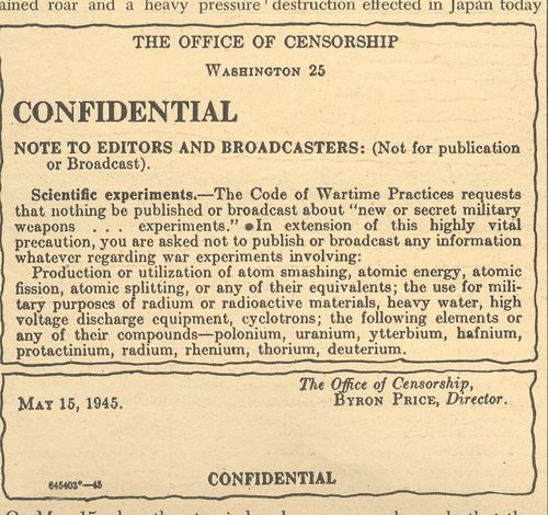
    ==Blog July 26=PM cvr bomb censor


    The other articles included “Bombs and Sabotage Stopped Nazi Experiment with Heavy Water”, “New Atomic Era Could Revolutionize Mankind’s Whole Manner of Life/Power Harnessed for Destruction Has Limitless Constructive Possibilities”, big two-page story “Stimson Reveals How Work on Bomb Was Organized”, “Bomb’s Death Range Believed to be 4 Miles”, “Four Scientists who Will Plan Postwar Uses of Atomic Energy”, “Harnessing of Atomic Power research Strengthens US Research”, “If a Piece of the Sun Were Placed on Earth”, “End Not Yet Truman Tells the Japanese”, and another 12 articles.

     ==Blog July 26=PM cvr bomb artoon

    There’s another baffling article “Steel Tower Vaporized in First Test”, discussing the shot at Alamagordo—it must have been the case that there was an enormous amount of material divulged by the government in the hours after the explosion at Hiroshima .  The work at Columbia is also chronicled, as is the personal life of the man in control, General Leslie Grove (and how completely in the dark his wife was, and so on). 

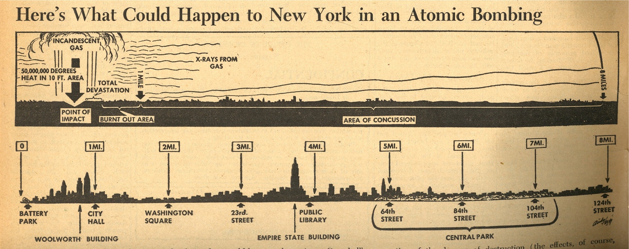
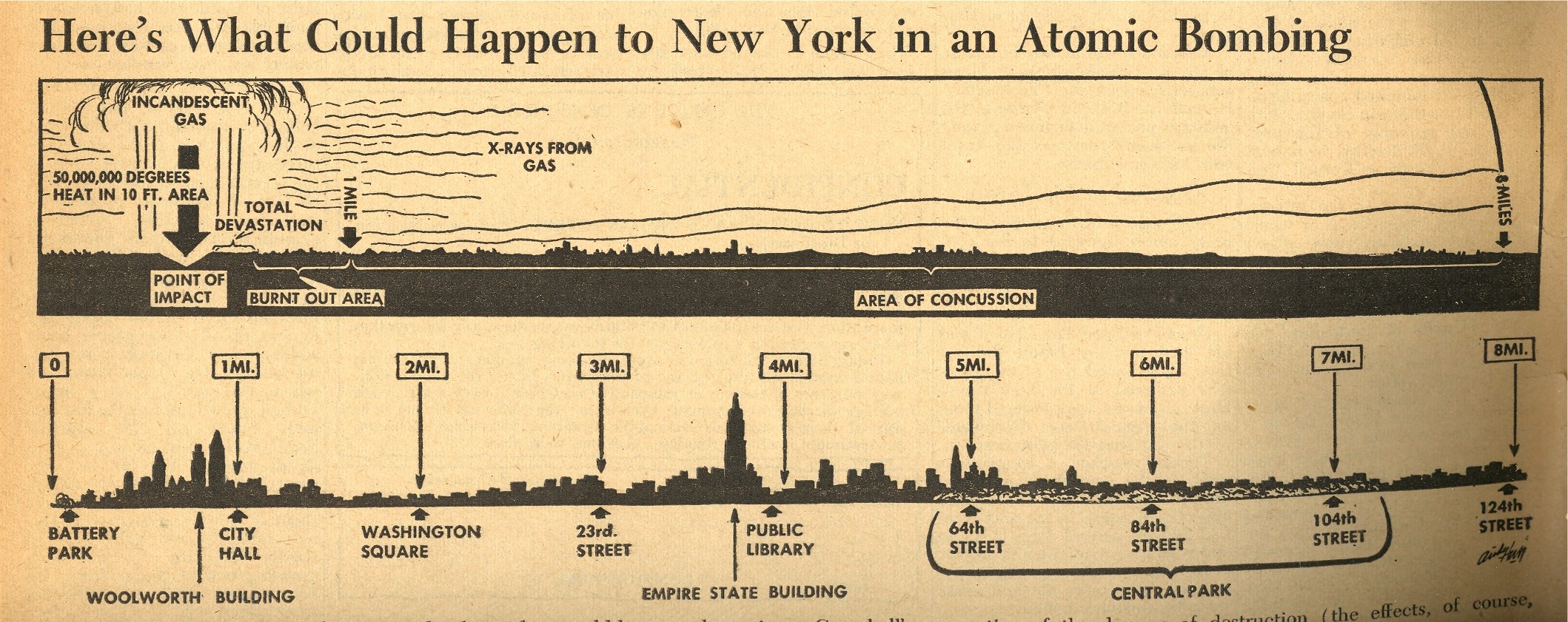
    One of the most interesting objects to me though is the small graphic on page 7 which shows what effect the Hiroshima atomic bomb would have if dropped on New York City—it was no doubt gigantically sobering to anyone who looked at it, and brought the power of the bomb and its destruction to a common, understandable point.  I’m not an historian of the first newspaper coverage of the bomb, but it strikes me that this may well be the first graphic to depict the effects of an atomic bomb exploded over NYC.

    ==Blog July 26=PM cvr bomb map
     

    In any event, the overall coverage of the event was stunning given the short amount of time to do the research, writing, and publication.  Truly a great effort. 

    Notes:

    1. PM (1940-1948) was a left-wing newspaper funded by Marshall Field III, and was home to excellent reporting.  See here for more details. Among the staff writers was I.F.Stone and staff photographers Margaret Bourke-White.  Other contributors included Heywood Hale Broun; James Thurber; (the great) Dorothy Parker; Ernest Hemingway; Eugene Lyons; Ben Stolberg; Malcolm Cowley; Tip O’Neill;and Ben Hecht.

    2. Actually, NO issue of PM had advertisements–it was entirely ad-free. (And even so it still came close to making money after 8 years.)

    PM‘s stated mission:

    PM is against people who push other people around.   PM accepts no advertising. PM belongs to no political party. PM is absolutely free and uncensored. PM’s sole source of income is its readers–to whom it alone is responsible.PM us one newspaper thayt can and dares to tell the truth.

    Theodore Geisel (Dr. Seuss) was a cartoonist for PM (see here for his War cartoons) as was the great Crockett Johnson.


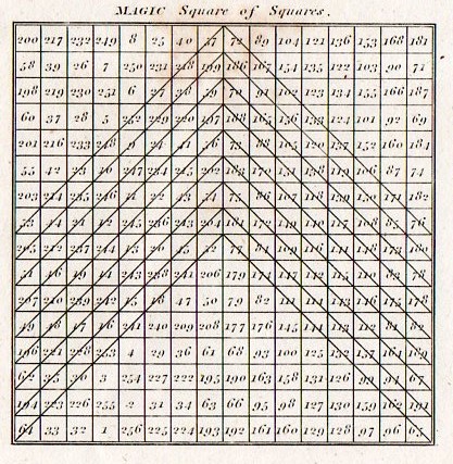
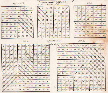
  • Logic Trees, Magic Squares, Magic Circles and Magic Square of Squares

    JF Ptak Science Books LLC  Post 1238

    [Associated posts: The Mother of all Renaissance Logical Graphs, The Knight’s Tour, Porphyry and Boethius and Census Art and the Display of Quantitative Data, 1860.]

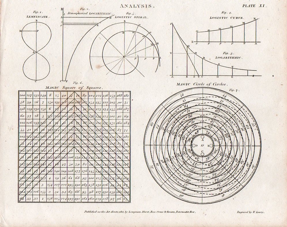
    Magic square and circles det sq881
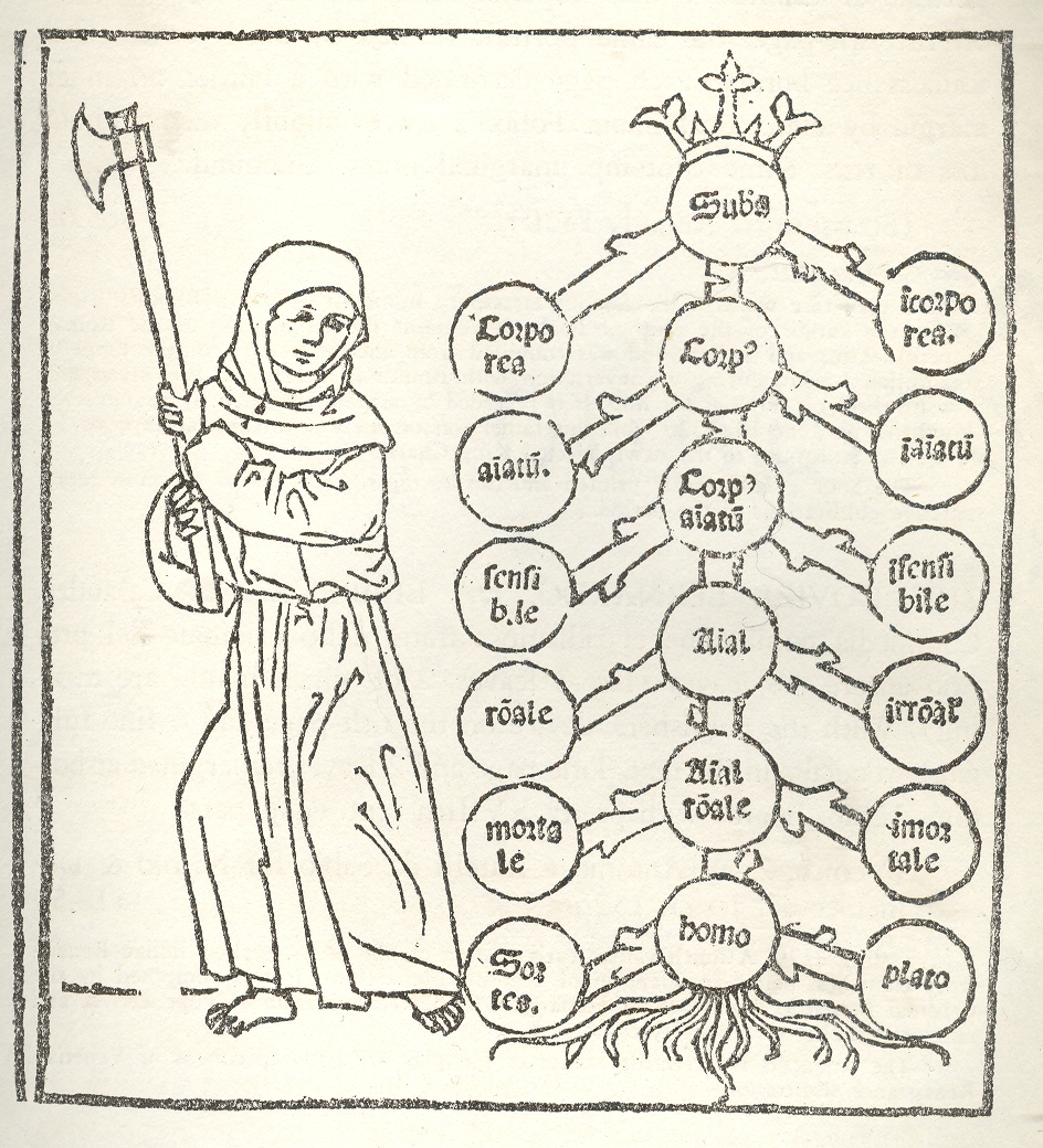
    Well now:  I don’t know what the provocation or inducement is here to hurtle this axe-swinging monk to attack Porphyry’s Tree1, though it would be interesting in a forensic sort of way to know what the tree’s section might reveal. The “tree” was a diagrammatic creation of a 3rd century Syrian mathematician/logician/philosopher named Porphyry who– much taken with Aristotle (and with the Categories in particular)– developed a systematic approach to the organization of thought in diagrammatic form.1--logic tree

    What’s inside a tree of logic and memory?  Is there a  xylem-y/phloem-y stuff besides a three-dimensional representation of the structure of organizational thinking?  Or is the 2-dimensional rip a fatal blow to other dimensions, and like Eddington’s Turtles, it’s a simple slice of Flatland all the way down?  

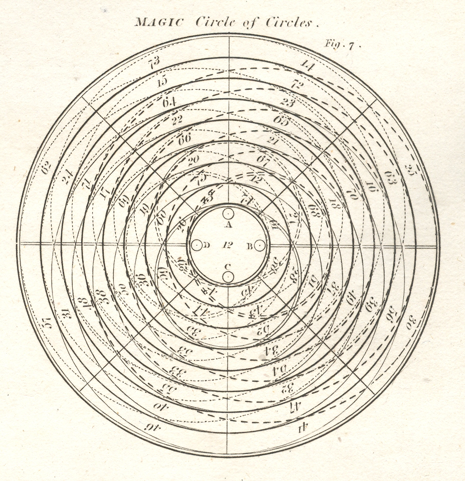
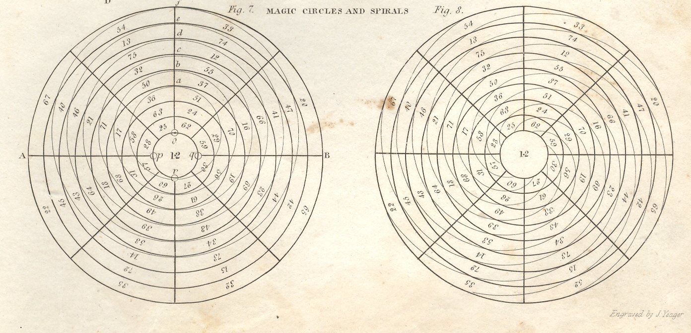
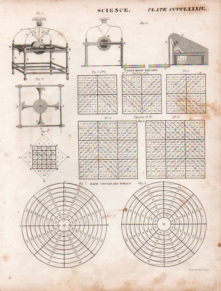
    Perhaps Porphyry’s tree rings would look like this, a magic circle or spiral, which would make some sense, and would bring to bear an associated use of turtles—or tortoises, I should say.  It turns out that perhaps the very first use of the magic circle, rolling back its origins through the Islamic world to India and to Persia and then to Japan,  and then finally to China where, in about 2000 BCE, the magic square appears in an image with the Emperor Yu,  inscribed on the back of a tortoise.

    1--logic tree magic circle 

    1--logic tree magic cricles

    [Magic circle source:  Abraham Rees Encyclopedic Dictionary , printed 1805-1815. The originals are available from our blog bookstore.]

    Magic squarezz and circles det883

    Magic square and circles880
    Magic squarezz and circles882

    Notes:

    1. This image appears in the rare Destructio sive eradicatio totius arboris Porphirii : magni philosophi ac sacrae theologiae doctoris eximii Augustini Anchonitani ordinis fratrum Heremitarum Sancti Augustini, cũ quadã decretali eiusde, published in 1503.


  • Motion and Change in Natural Sculpture–the Galileos of Clouds and Snowflakes

    JF Ptak Ptak Science Books   Post 1235

    Blogcloud_howard It is odd to think among the great classifiers of nature, including even the lofty-namer Aristotle, that clouds were not scientifically classified until the early 19th century.   Here they are, just about the biggest thing we have as earthlings that are gigantic and close to us, and nobody offered a good classifications scheme until 200-odd years ago—a pretty slim margin of time  in the terms of recorded human history. 
    Clouds are of course problematic, what with floating around and all—but if you didn’t already know the relative newness of their recognizable names isn’t it shocking to learn this bit of history? For the most part I think clouds must have been thought as being too transient, changeable, whimsical, wispy, to be given proper names.   The great scientist and classifier Lamarck tried to do so in his  Annuaire Méteorologique of 1802, and really is the first to try this, but his ideas weren’t terribly good (especially compared to the rest of his work), and it seems as though he left his best thinking effort on clouds at home.  For example, he gave us Hazy, dappled, massed, broom-like and grouped clouds as classifications (in French, respectively, en forme de voile, pommelés, attroupés,  en balayeurs and groupés).  They seem quite “French” to me, but largely outside the scope of being useful. 

    It was the English pharmacist and chemist Luke Howard who in 1803 gave a greater bit of thought to structuring cloud names, classifying them according to size and shape and giving them Latin names—and this forms the basis of our naming clouds to this day.  Howard was perhaps the first, greatest, meteorologist, producing On the Modification of Clouds, (in which he describes his naming system, the “modification” part actually meaning classifying rather than changing),  The Climate of London, and the first textbook on weather,  Seven Lectures on Meteorology.  Howard’s system was expanded in 1887 by Abercromby and Hildebrandsson, who further classified clouds by height above ground as well as by appearance (and utilizing Howard’s naming system). 

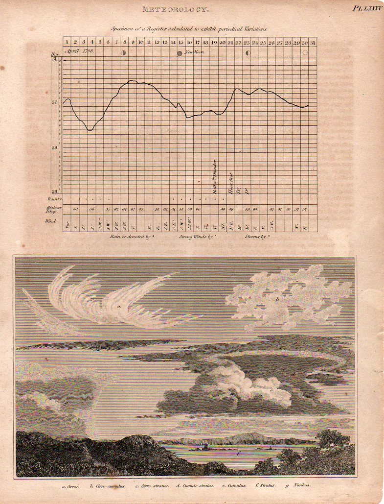
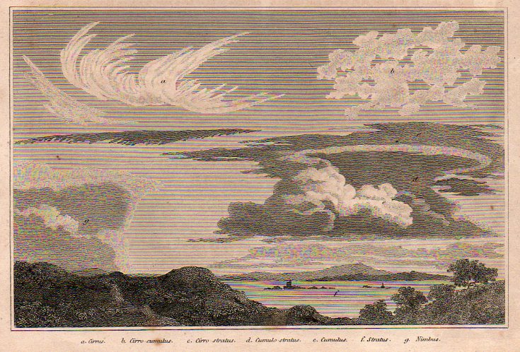
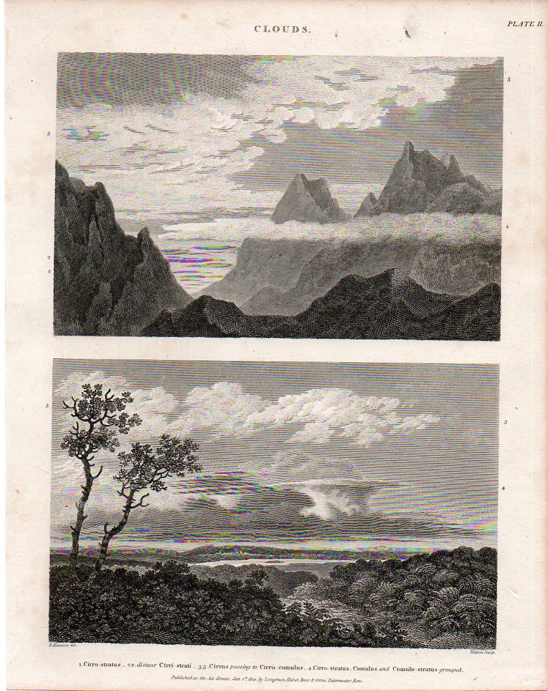
    Here (below) are two fine, early examples of cloud-naming for the scientifically-minded of the British elite, finding their way into print in the fabulous, ingenious and  mammoth (45-volume) Cyclopædia, or The New Cyclopaedia, or, Universal Dictionary of the Arts and Sciences, edited by Abraham Rees (1743-1825).  The work was published between 1802 and 1820, and was the resulting effort of 100 contributors who generally wrote monograph-length entries, contributing to a final tally of close to 40 million words.  I’ve particularly enjoyed the illustrations like those below—some of which have become iconic—and especially the fine and deep engraving of Wilson Lowry.

    {Both of these images below are available for purchase from our blog bookstore, here.]

    Clouds875

    Cloudsb876Howard began his system by identifying three basic shapes to clouds: heaps, layers, and curls.  Heaps of separated cloud  masses with flat bottoms and bulbous, splayed, tops, which he called cumulus, which is Latin for heap; the Latin stratus was applied to clouds in layers which were much wider than they were thick; and again to Latin for cirrus, which called out the wispy curls of clouds.  (Rain clouds were given the Latin nimbus, for rain, and so on.) 

      Cloudsbdet877

    It is interesting and romantic to think of Howard being moved in his love of clouds as many Brits and Europeans were in the Volcanic Year of 1783 by the enormous eruptions of the Eldeyjar (Iceland) and Asama Yama (Japan) volcanoes—the force of their eruptions caused enormous changes in the skies (especially in Europe), creating vast sky-borne tapestries (the “Great Fogg” in England) and for such extended periods of time that it would have beenBlogsnowflake_hooke impossible for the scientifically-minded Howard not to see them. 
    Blogsnowflake_bentley

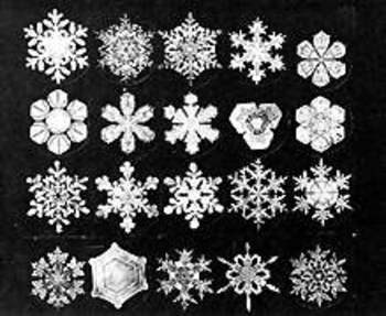
    Similar, in a way, to clouds is the snow crystal (snowflake)—they change forms in their lives from sky to ground, and may well disappear on contact with a warm surface.  Of course unlike clouds they may fall and be captured, kept even, though the ability to actually perform some sort of scientific something with them didn’t occur until 400 years ago, which means that snowflakes passed in and out of human existence being very simply named (in most languages) as a mass group, and not classified at all.

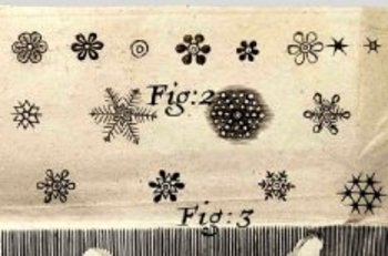
    Johannes Kepler thought very deeply in In 1611 publishing a short treatise called On the Six-Cornered Snowflake, thinking that perhaps their (mistaken) six-cornered symmetry revealed something much deeper about the basis of nature and the universe. The 26-year-old  Robert Hooke seems to be recognized as the first to throw the snowflake under a microscope, publishing drawings of them and just about everything else that he saw in his monumental (and tall, being 13-inches tall) Micrographia (1665)–the first truly scientific book of modern times.  The largest of the large images was saved for the flea, showing the unsuspecting public the great and beautiful nature of what seemed like a fantastical beast (under magnification).  Snowflakes appeared in the book, revealed in their intricate and seemingly-symmetrical nature.  Fantastic, unimagined images. This aside, he seems to have, um, borrowed these images from an earlier work, Thomas Bartholin’s  De Nivus usu Medico Observationes Varieae, 1661.  But so it goes. 
     

    The Galileo of the snowflake was Wilson Bentley (1865-1931), an autodidact Vermont farmer, seen by fellow hamlet-dwellers as odd and off, who figured out how to photographically and beautifully record the intricacies of the snow crystal world—no one had ever done this so dramatically, with such gorgeous results.  It really was as though he was able to record the heights of the mountains of the moon with a slender telescope in Pisa, 350 years earlier. The results of his decades of experience were published  in 1931 his book Snow Crystals, containing more than 2400 snow crystal images.  On the heals of Bentley’s accomplishments came the classically trained nuclear physicist Ukichiro Nakaya, who was truly the first person to apply a scientific classification to snowflakes, and who published his intrepidly-beautiful work in a 1954 book entitled Snow Crystals: Natural and Artificial.  His classification system of the various types of snowflakes would prove vastly more useful, interesting and appealing than that published by the 1951 the International Commission on Snow and Ice, and forms the basis of the discussion of snow crystals today—a classification system of a massively-occurring phenomenon that is younger than me.