A Daily History of Holes, Dots, Lines, Science, History, Math, Physics, Art, the Unintentional Absurd, Architecture, Maps, Data Visualization, Blank and Missing Things, and so on. |1.6 million words, 7500 images, 4.9 million hits| Press & appearances in The Times, Le Figaro, Mensa, The Economist, The Guardian, Discovery News, Slate, Le Monde, Sci American Blogs, Le Pont, and many other places… 5000+ total posts since 2008.

Category: Maps/Diagrams of Imagination & Ideas

  • Where is THE West? And: How to Find Nowhere.

    JF Ptak Science Books  Post 320

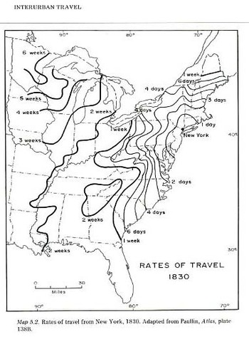
      This wonderful map is from Charles Paullin and John K. Wright Atlas of the Historical Geography of the United States, Washington, Carnegie Institution, and New York, American Geographical Society, 1932. It is just so very interesting and unusual–I’m not so sure that I’ve seen another map quite like this, illustrating travel time and difficulty..  One major stand-alone feature here for me is the distance from New York City to my own area of the U.S., the southern Appalachian region of western North Carolina: it took six days to get to Savannah from NYC and two weeks (!) to get up here in the mountains, which looks to be about the same amount of time it took to get to the Chicago area.  Of course once you got to Asheville in 1830 you were, well, probably looking to get somewhere else. I’d take it that the turkey population vastly outnumbered the people.  Maybe the horses did, too.  Getting back on track here though the West in the U.S. at the time began just on the other side of the state of Tennessee, and it wasn’t but a couple (?) of censuses before this that the West was right about at the Cumberland Gap/Ohio River basin region.
    File0844

    Perhaps this leads us to a more interesting if badly-asked question:  where does the American West begin? 

    This is an awfully tricky question, best left to the answer that pops into your mind the instant you hear the question, before the problems of what the sentence entails creep in.

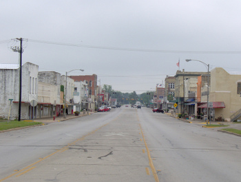
    Locating where the West begins is a curious, personal adventure–is it on the other side of the Mississippi, or does it really start in Texas, and once in Texas does it start in Austin or the sleepy Brazos? Does it really begin where the sign says it did, at Meacham Field in Fort Worth?
    Blogoctlast_piovcture

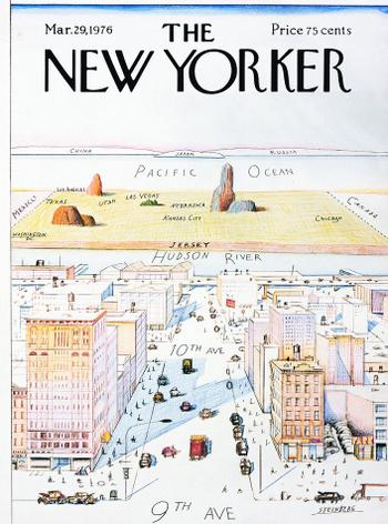
    It depends on the era, too, as we just said above; in the 18th century the American West was really out there with the makers of the martyr Bibles in Ephrata, which means that the rest of the  place was really very big.  And of course you can go all the way back to the beginning of European colonization here, all of North America was the West, at least to the people who were boarding the ships thousands of miles away across the Atlantic. And even once they got here the West was problematic–for the Spanish in the southlands there doesn’t really seem to be a “west”, only the northlands. In the 16th century the West was just creeping into Pennsylvania (Penn’s Forests), and the French and Indian War in the mid 18th century was fought over the control of “the West”, the crux of it all heading down to the forks of the Ohio at Pittsburgh.  Even in the late 18th century, the West was still not all that far away, relative to what we think of today, what with Kentucky being the first “Western” state admitted to the Union (in 1792).  It would probably be easiest just to say that the Mississippi River is the dividing line; after all, Lewis and Clark departed (in 1803) on their expedition from St. Louis (as did hundreds of thousands of other people later in the century who were seeking their new life in the West).  Then there’s the West of Saul Steinberg. who puts the whole thing on the other side of the Hudson…I’m not so sure if the West didn’t start for some people somewhere along 11th Ave.

    And where does the West “end”?  Does the West make it all the way to California coast, or does it stop in the desert, east of Sacramento?  Do people think of Oregon and Washington as the West; certainly they’re western, but are they The West?   To really complicate things, I guess you could define the middle of the West and look for the boundaries.  But the middle of the West usually seems to me to be flat and red and not terribly high; who’s to say that a nice town in Colorado (Salida?) might not be the middle of the West, even if it is 7,000 feet high?   
    Blogoct_18steinberg

    Its a tricky question and probably most people have a different answer for it.  For that matter, what about the South?  Where does that begin? I’m in a southernish state, but I hardly think of Asheville as being in The South per se. Maybe we’re too high; maybe the place over 2000′ in elevation that are south of Pennsylvania are just Appalachia, and actually not part of the South.  Scotland Neck over on the other part of my state is definitely the South to me, but perhaps it isn’t too much very Southern for someone in the high delta, or taking an easy afternoon in Oxford, Mississippi, or anywhere else in the Louisiana-Mississippi-Alabama-Georgia block.  I know that to Robert Johnson and Honeyboy Edwards and Son House and  Muddy Waters and anyone else in Coahoma county that the South didn’t go all that far north from where they were sitting. .In maps from sat 1850-1890 that area is called “the deep south”; seems to me that anytime you have a geographical location with a qualifying prefix, you’re actually dealing with the real thing, everyone else without the prefix being pretenders, or just something else. 

    Same too for the North–is everything above Washington D.C. northern?  I wouldn’t tell my father that, being a Berkshire Hills (MA) boy; but that’s another problem, especially to someone in Bangor.

    So somewhere in all of this, after figuring out where all of these places start, somewhere in  there is a place in this country that rejects these geographical delineations–that’s the place I’d like to find.  (When I was describing this idea yesterday to a friend, Renee, a Texan via way of Alabama–like many of the defenders of the Alamo–the answer came immediately:  “Kansas” she said.

    I’m not sure I agree.  But then once I get past my immediate response (Texas without Trees), I start to think of a 3-D representation, trying to accommodate time.  I don’t have answer for the place that isn’t anywhere, but once you start drawing enough circles to signify where The North South East West is/are, there is sure to be a little spot that gets overlapped by all of the circles more often than any other place–and that is where I think you’ll find Nowhere.


  • Maps as Propaganda: the Nazi’s Use of Maps in the Hearts and Minds Campaign in Occupied Holland and France, 1943

    JF Ptak Science Books  Post 193

    Nazi Maps D Propaganda1

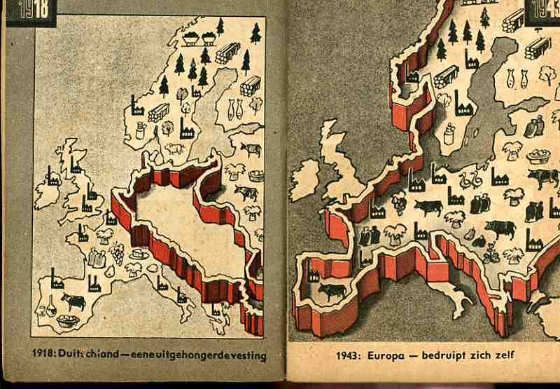
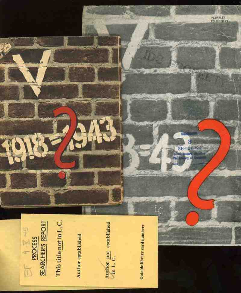
    These two, related, pamphlets were the products of the Nazi Propaganda engine and sought to affect the moral and intellectual stamina of the people in the occupied countries of the Netherlands and France in 1943.   Each stressed the enormous differences in the German state that took place in the 25 years between the end of World War I and the third year of the Nazi European part of World War II.  I’ve no idea whatsoever about the grander symbology  (if any) of these numbers associated with these two pamphlets (the Roman numeral for “5” and the 25 years of the difference and the “13” points (of the French propaganda) aside from the obvious mathematical implications.

    Nazi Maps D Propaganda2

    (The only interesting bit that I can find in the “18=43” from the French pamphlet is Luke 18:43 “Immediately the man could see again and began to follow Jesus, glorifying God. All the people saw this and gave praise to God.”. )   I find it curious that identical symbolism (?) was used for the two countries, and that the French version was simple comparative text (summarizing the differences in the two periods of time) while the Dutch version was mainly a picture book. 

    Nazi Maps D Propaganda3

    I would reprint the French version if it wasn’t so bloodily hateful.  (Suffice to say that this is so by looking at one example: in the last of the second issue of 13 points  Goebbels et alia wrapped themselves in the insulating fabric of the German “people” in the “resistance” against “Jewish saboteurs”—not the German political machine, and not the German military, but the German people, insinuating that the Nazi annihilation of the Jewish people was de facto sanctioned by the will of the German nation.  This is of course part and parcel of the fictitious and loathsome Protocols of the Elders of Zion (of which Henry Ford was a happy reader), a French work that was completely stolen and plagiarized by Imperial Russia in the early 1880’s and which, later,  Hitler used to both build his hate against the Jewish people and use (and acknowledge ) as the template for his early actions in the Nazi Party.)

    Nazi Maps D Propaganda4

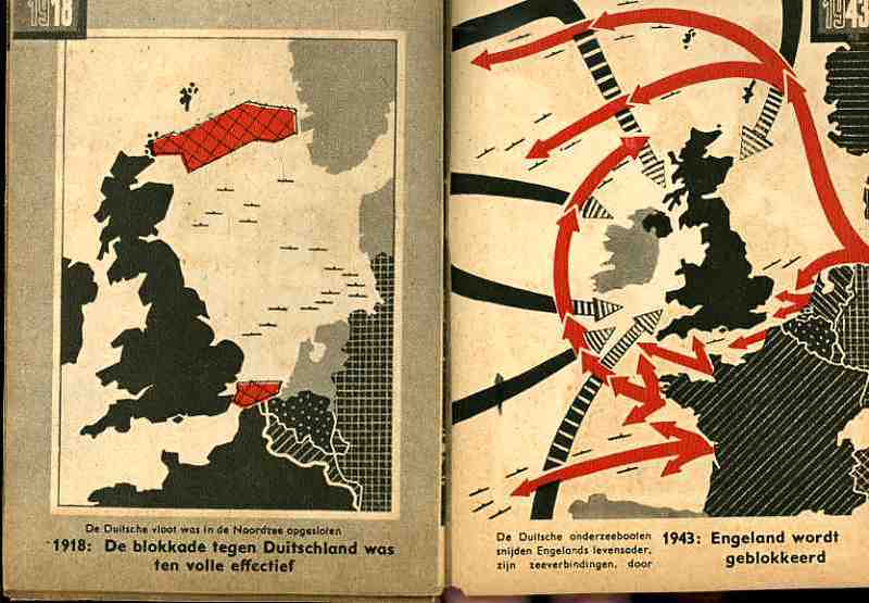
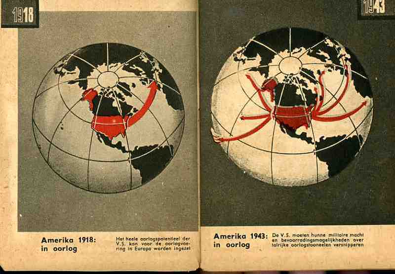
    The maps used in the Dutch publication are fairly general and issue a stark warning about the growth of Germany–and how Germany continues to grow through war.  The first that we reprint, above, tries to get the point across to the occupied people that England has more problems to deal with than would concern their attention with the Netherlands.  The second part of the first map crazily shows the attack upon England and the effectively exhausting attention it has to pay to many points of invasion.  Ditto for the second map, showing the spread of American concerns–the U.S. in 1943 would have far more to deal with in many points in a two-ocean war than to concern itself with or have the ability to think about the liberation of Europe and the Netherlands.  The last map shows the supposedly extraordinary growth in Germany’s  industrial and agricultural capacity. 

    In short, the maps tell its readers to just keep quiet, the German nation is mighty, and just wait for the end of the victorious German war.  The maps also addressed non-readers–of course the Dutch literacy rate was extremely high, but you didn’t have to be able to read the description of the map to understand its blunt message. (This makes me wonder if the maps really weren’t intended for scare tactics against children.)  As Boss Tweed once infamously reported–that he had no fear of editorials because his constituency couldn’t read–he hadn’t counted on the political cartoons of Thomas Nast–which could be understood by a non-reader–and which wound up being one of the direct causes of his exposure and downfall. 


  • Nazi Propaganda: Scare Tactics in a Hearts and Minds Campaign, 1940

    JF Ptak Science Books   Post 220

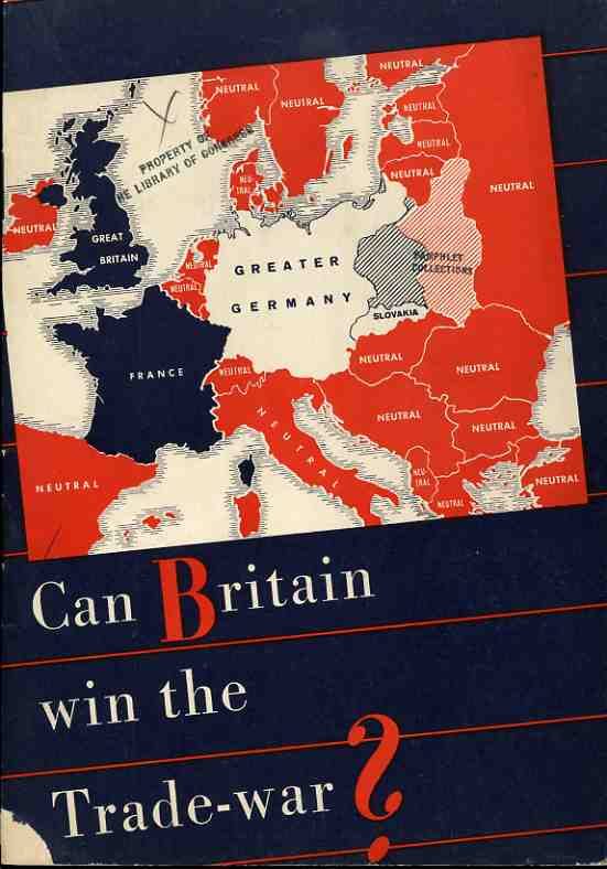
    The Nazi propaganda office published this effort (printed in August 1940) with every intent of making it seem as though it was produced in the U.K. as a sober reconsideration of fighting against the Germans, casting much of the argument in terms of economics. It was a relatively soft-sell effort in a hearts-and-minds campaign, hitting its target audience with reminders of how alone everyone on the British Isles were in the hard summer of 1940. 
                                                                   
    Nazi Propaganda Map  Can Britain win trade war


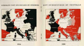
    These two maps compare the economic and trade situation of 1914 and 1939, from the Nazi perspective.  In 1914, the British, “as a preliminary condition for the success of the hunger-Blockade, only achieved, however after four years if struggle during which Britain was to sustain heavy losses”.   They announce with exclamation (!) that for 1939 there was:

    “a totally different situation! The encirclement of Germany miscarries, leaving way for the expansion of Germany, and the way for her trade with neutral countries, especially with the Balkans and Russia…thus is the blockade against Germany a hopeless enterprise”.   

    The Nazis’ state that “Britain…energetically refuses to admit the hopelessness of her winning this trade war and tenaciously grasps upon all kinds of unfounded rumours…”, all the while refusing to discus the bombing of Britain or any other aspect of military war

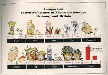
    Blogaugust_26_nazi_prop_2_map450                                                                                                                                                           After a dozen pages of making the case against the British position in being able to take care of itself, there is this folding quantitative display, making a diametrical-pictorial presentation of the British failings.  The Nazis show that they overpower the British in the ability to supply itself with grain, flour, meat, cooking fat, cheese, eggs, sugar and vegetables–in every area, in fact, except for fish. 
    Blogaugust_26_nazi_prop_food454

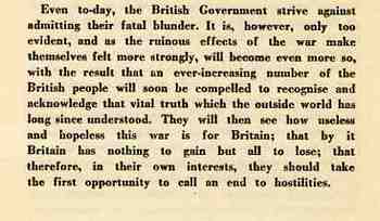
    This is the summation of the pamphlet, the last paragraph, asking the Brits to just give it up and quit their fight. 

    Blogaugust_26_nazi_prop_text452


  • Bombing Britain, 1940–a View of the Battle of Britain from Germany

    JF Ptak Science Books  (an earlier post edited and expanded)

    Dsc04742_2
    It is essential to look at objects from alternative angles, especially in science, in order to determine the correctness, or fitness, of a finding, or opinion.  Even when consolidating data or evidence regarding the confirmation of an established bit,  you may very well find other strands of loose data that could help illuminate even a well established or iconic societal “given”.

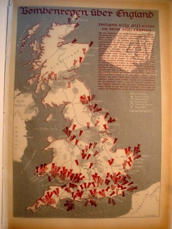
    That the war was not going well for the Allies in September 1940 is an understatement—and the chief allies at this point excluded the United States, happily now recovering from the Depression, and still a full 14 months away from entering the war. 

    Dsc04739

    What is very weird to me is that after having looked at every issue of LIFE magazine at least three times  from the start to the end of World War II, that there are more advertisements using war images than there are images of the war itself.  This actually continues into the spring of 1942, when LIFE got really busy, the war got really messy, and people started really dying.  And frankly even the coverage of Pearl Harbor in no way lived up to what I thought the coverage of a photo-magazine like LIFE would be. This is not a scientific study.  It just strikes me as odd, or propagandizing, that there should be such relatively scant, or undervalued, coverage of the fighting when sanitized images of that same fighting were being used to sell socks and shaving cream and cigarettes and such.  I understand the power of hearts-and-minds campaigns, but this seemed so amateurish, boorish even, that it just didn’t approach the level of a psychological ploy to pacify an American public that had virtually no interest in attending the European Theatre.