A Daily History of Holes, Dots, Lines, Science, History, Math, Physics, Art, the Unintentional Absurd, Architecture, Maps, Data Visualization, Blank and Missing Things, and so on. |1.6 million words, 7500 images, 4.9 million hits| Press & appearances in The Times, Le Figaro, Mensa, The Economist, The Guardian, Discovery News, Slate, Le Monde, Sci American Blogs, Le Pont, and many other places… 5000+ total posts since 2008.

Author: JF Ptak

  • Ghost Trails of the Mississippi River: Harold Fisk’s Geological Map of 1944 (Expanded)

    JF Ptak Science Books   Post 144 (from 2008) expanded
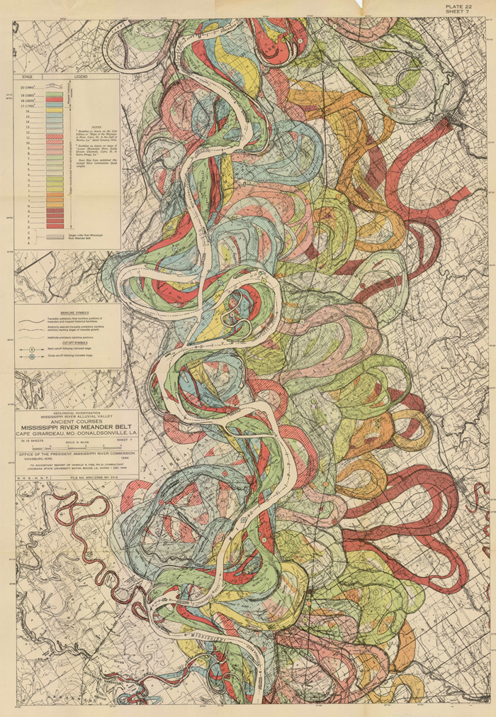
    Fisk map plate 22

    Understanding the Mississippi River was the skeleton key to understanding pre-Civil War America.  There was really nothing else quite like it—the Ohio River and the attention paid it by Collot and others  was of great importance to understanding the early far Western (east of the Mississippi River) adventures of Colonial and Post-Revolutionary America, as was the Missouri to early 19th century American exploration and settlement, but the Mississippi loomed over all.  Like saying that Babe Ruth was a fabulous baseball player or that Richard Feynman was a brilliant physicist is a bland statement of the obvious—the understatement hollowing and becoming more brittle the more deeply their “records” are studied showing how truly incomparable they were—the Mississippi, “The Father of Waters”, is really the Big Deal in the history of the U.S. 

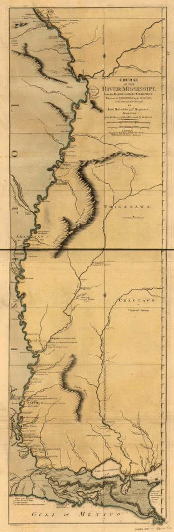
    And in spite of the fantastic maps made of river through the 18th and 19th centuries (like these gorgeous and iconic examples by John Senex in 1721 (A map of Louisiana and of the river Mississipi [i.e. Mississippi] : this map of the Mississipi [i.e. Mississippi] is most humbly inscribed to William Law of Lanreston, esq.)  or Robert Sayer  (Course of the river Mississippi, from the Balise to Fort Chartres; taken on an expedition to the Illinois, in the latter end of the year 1765. By Lieut. Ross of the 34th regiment: Improved from the surveys of that river made by the French. in 1772, or even Coloney & Fairchild’s Ribbon Map of the Father of Waters (below, a whopper, measuring in at 337 cm (and which was issued on a wooden spool for the use of travelers on board steamships moving along  the river), there were very few that gave you an idea of the *history* of the river.

    That was achieved in spectacular flourish by  Harold Fisk (in the map above) in 1944 in his Geological Investigation of the Alluvial Valley of the Lower Mississippi River (U.S. Department of the Army, Mississippi River Commission, 78p) The map showed the very ghost trails of the river over time, and trying to show where it wasn’t was the great question.  He tried to reveal the history of the valley by mapping  and dating all physiological features of the river and tried to reconstruct the channel changes with what were to become speculative appreciation.  Nevertheless, he did make a tremendous attempt at explaining the courses of the Mississippi over time by utilizing his own excellent maps and a little generative thought.  This might not be the most accurate map of the courses of the Mississippi over time, but in 1944 it was really a spectacular achievement in cartography and general thought.  And the thing was just drop-dead beautiful.

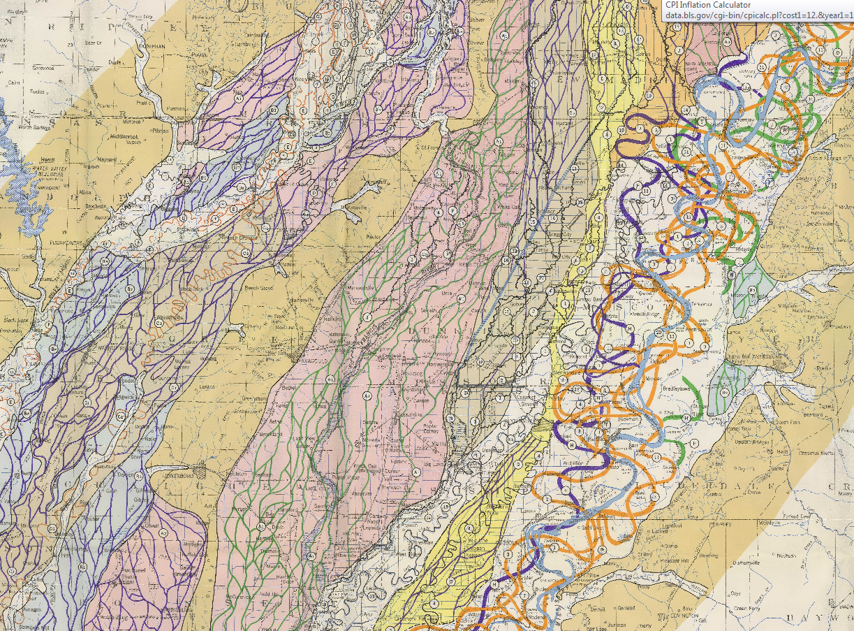
    Here’s another sample from the suite of maps:
    Fisk Map

    [Source: http://biotech.law.lsu.edu/climate/mississippi/fisk/plate_15-1.pdf]

    And another detail, from map 15, in the vicinity of Baton Rouge:
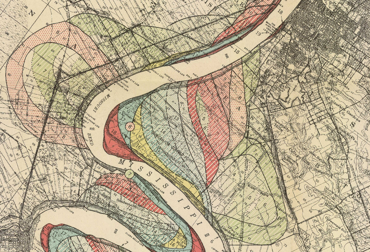
    Fisk map baton rouge

    • The full text is available here from the LSU library: http://biotech.law.lsu.edu/climate/mississippi/fisk/fisk.htm
    • For a very quick, elegant overview see Radical Cartography which has all 15 of the maps displayed at once, along with a key chart :  http://www.radicalcartography.net/index.html?fisk
    • Also go to the U.S. Army Corps of Engineers site and click on the “Fisk oversize” link in the left-hand “documents” column:  http://lmvmapping.erdc.usace.army.mil/index.htm
     

    Mississippisenex

    Mississippi_1765

    Lloyd’s new map of the Mississippi River from Cairo to its mouth:
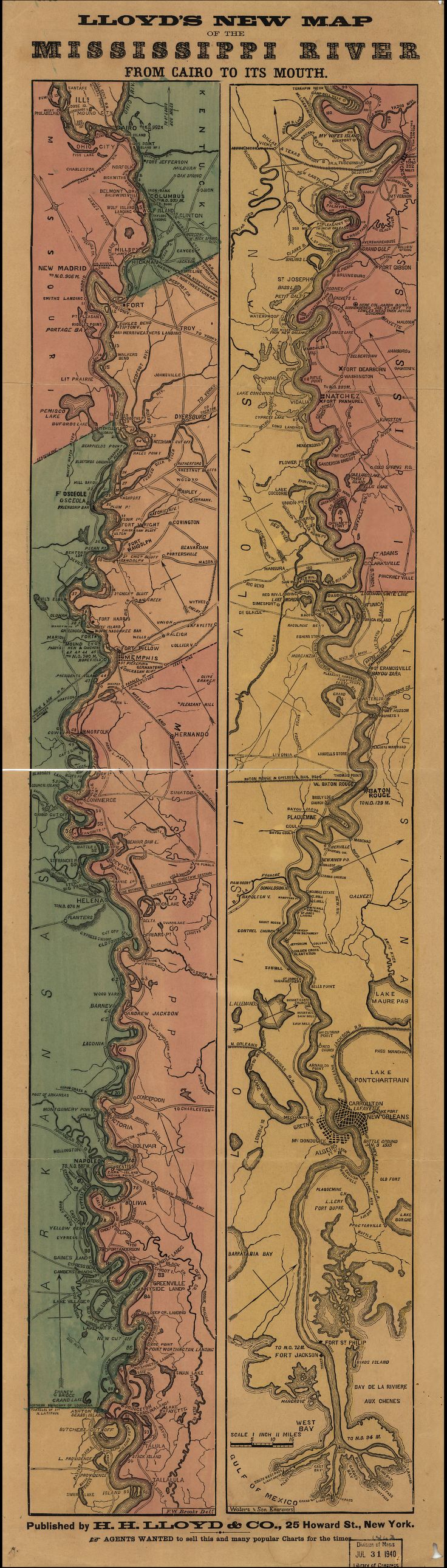
    Mississippi Lloyd map[Source: Library of Congress, http://www.loc.gov/item/99447107/]

    And the great “Ribbon map of the [Fa]ther of Waters.Created / PublishedSt. Louis, Mo. : Coloney & Fairchild, 1866”: 

    (Very zoomable version here:  http://www.loc.gov/resource/g4042m.ct000797/  The initial image comes up about 4mm wide (1)–don;t be discouraged, just start clicking away at the magnifier and it will zoom right in…)

    Mega-long scroll follows:
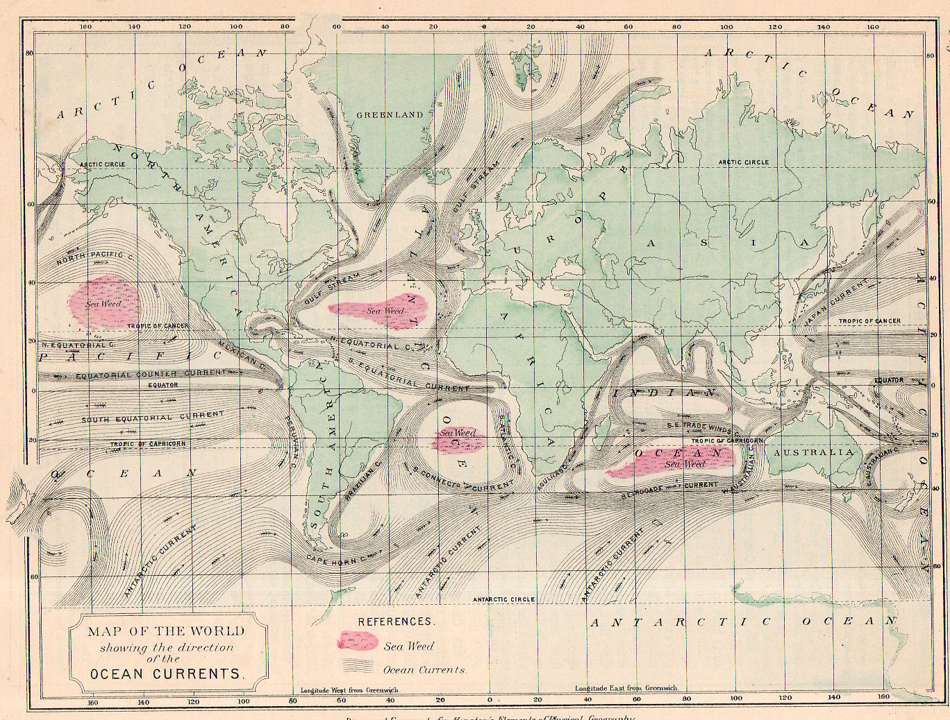

  • A Map of Currents and Seaweed, 1886

    JF Ptak Science Books    Post 2457

    Map ocean current 1886968

    I think that if you squinted your eyes a little to deform your visual field and then looked at this map of the Earth’s ocean currents that what you might see is…Mars.  At least that’s what I can see if I concentrate on it, or at least the Mars of 1880 or thereabouts, with its large and blotchy seemingly mobile and ambiguous forms skirting around the planet.

    • “This map may be purchased at the blog’s bookstore, here.  

    That said this map does represent a high achievement, displaying the elements of the still young-ish science of oceanography (or at least in the form presented by Matthew F. Maury) and showing the movements of the ocean currents.

    Map ocean current 1886969

    This maps comes about a century after the first map to truly distinguish the Gulf Stream (the B. Franklin/Folger map of 1768-1785) and shows the remarkable activity that must have come with the acquisition of the data necessary to show on even this popular map.  There were earlier attempts, of course, notably by the great/problematic Athanasium Kircher in his Mundus... of 1662 though his effort was largely theoretical (and for what it was worth likened the currents to something similar to blood moving though the body, which at least used the work of William Harvey) given the lack of available hard data.  (Eberhard Happel is on a similar wavelength as Kircher with the currents map, and published his map a few years later, though he was mainly a science popularizer who “relied” heavily upon the Kircher map and was nowhere near to being Kircher’s intellectual rival, his map is still interesting given its very heavy lining and beauty.) 

    In any event, the Houston map is clear and concise–and given its 7″x 9″ size, remarkably compelling.

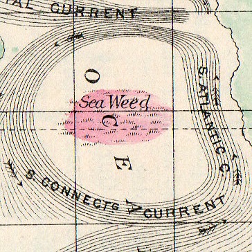
    And I just love the seaweed mapping.  


  • Zones of the Variables (Map of the Winds, 1886)

    JF Ptak Science Books   Post 2456

    Map winds 1886965

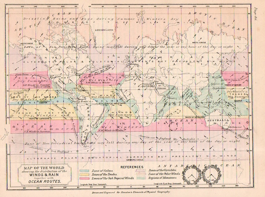
    The idea of a global map1 of the winds was still something relatively new when this map was published in 1886.  It represented a state-of-the-winds accomplishment and was published in the popular press–just a century earlier the idea of the completeness of a map of this sort for such a variable as The Wind was still of great speculation.  But aside from the great scientific achievement of being able to display such enormous quantities of data in this way, the map has its artistic element, though almost all of this is done by the reader.  For example, out-of-context this map depicts the delightfully- and disturbingly-named Equatorial Calms and Doldrums, Calm of Cancer, Calm of Capricorn, Zones of the Trades, Zones of the Variables (!), Zones of the Polar Winds, and Monsoon Regions. 

    • This map is available for purchase via the blog’s bookstore, here.  

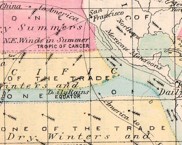
    Really though this small (7″ x 9″) map is impressive for showing so very much big information in a small place: in addition to the poetic calms and doldrums, it shows areas of drizzle and fog, areas that have snow in spring and autumn, and the periodicity of rain.

    Map winds 1886966

    It naturally shows trade routes (so dependent upon the winds) and then goes on to display prevailing winds and then to name some of the the important ones, including  the Northers (central North America), Simoon (Arabian Peninsula), Sirocco (Mediterranean), Solano (Spain), Chamsin (Egypt), and Harmattan (West Africa). 

    It is a lovely map that becomes even more so the more closely you look at it.  

    Notes 

    1. “A world map from 1891 showing the distribution of the winds and rain, together with ocean routes”,  by Edwin J. Houston, and published in The Elements of Physical Geography (Philadelphia, PA: Eldredge & Brother, 1886). 7×9″  Hand-colored lithograph.


  • The Liberty Ball March of 1918–a Superior Photograph

    JF Ptak Science Books  Quick Post

    WwI--photos--flags parade039

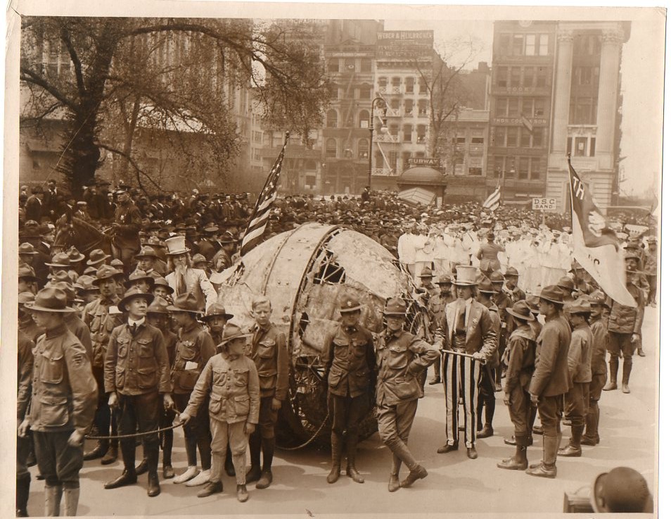
    I was looking through the 1918 volume of Popular Mechanics for an particle on an uphill walking machine that was supposed to look very much like an early bird-shaped flying machine when to my high happiness found the following picture of a WWI bond drive. Earlier in this blog I posted an image of this event without knowing what the image actually depicted, and now with the accompanying text in the Popular Mechanics volume I now now its story.  

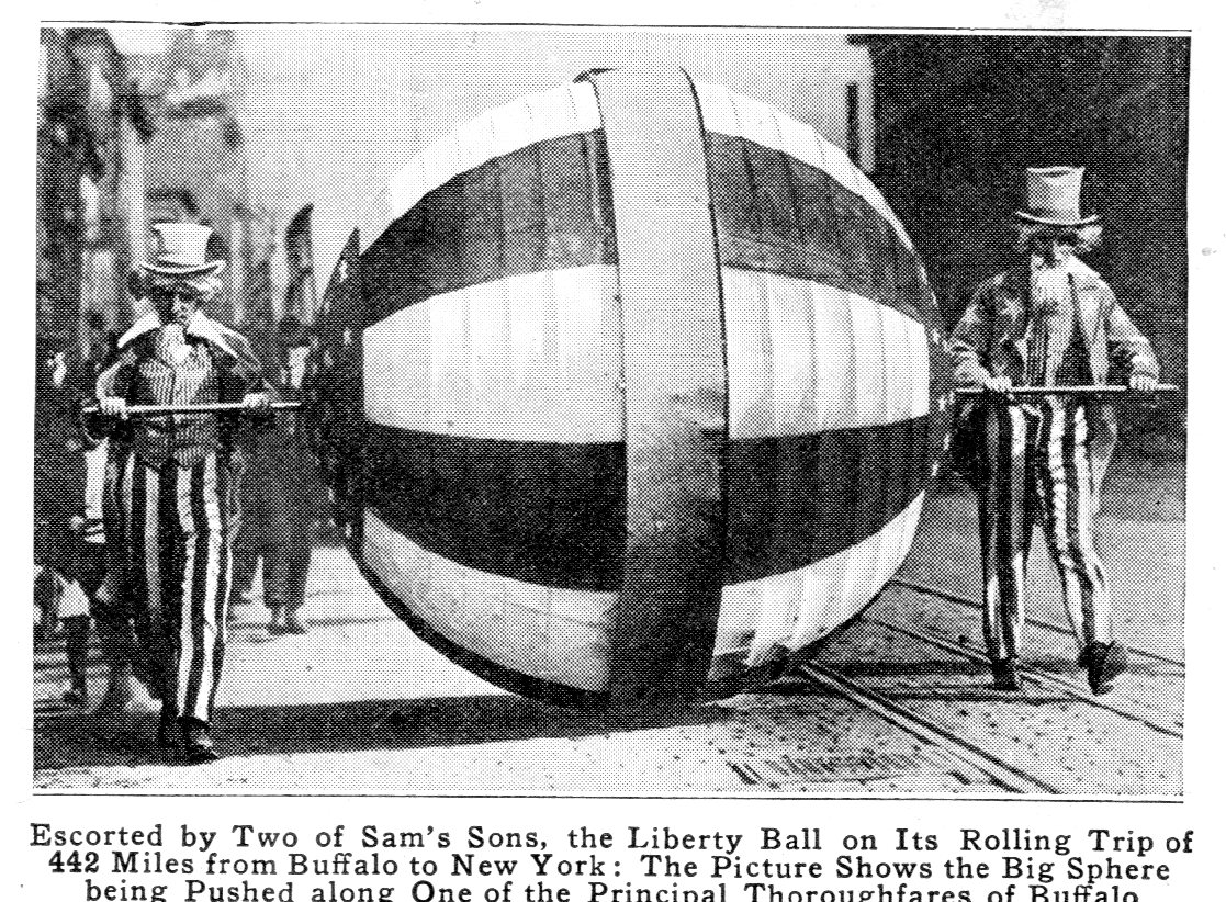
    First, the photograph from Popular Mechanics

    Wwi liberty ball964

    (The image quality is not high in this half-tone (the original is 2″ x 3″) but it serves nicely.)

    And the text with the explanation of the ball:

    “One of the features of the recent Liberty Loan drive was the liberty ball a seven foot red white and blue sphere that was rolled from Buffalo to New York by two sons of Uncle Sam dressed in traditional attire The ball started on its long trip the first day of the bond campaign and reached Gotham on the closing one Keep the ball rolling was the slogan that helped to sell many bonds.”

    And so now I can correct the original writeup:

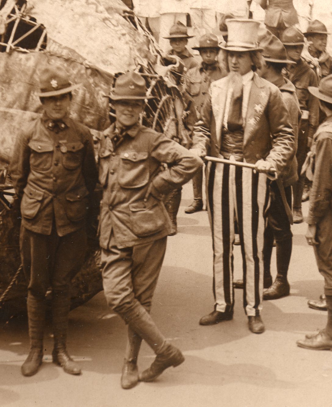
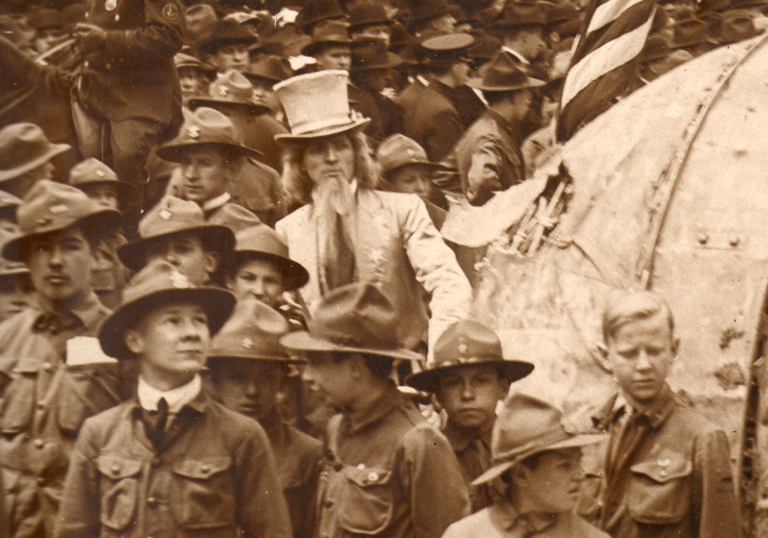
    Like its more-famous WWII counterpart, scrap drives during The Great War were also frequently conducted.  This is an original photograph showing just such a thing, depicting two Uncle Sams surrounded by Boy Scouts pulling a large hollow metal sphere. The sphere was rolled from Buffalo NY to New York City in an effort to raise awareness for the purchase of Liberty Bonds. By the time the ball reached NYC, it showed definite signs of wear and tear.     

    And of course this is a great photo.  

    • The original is available at our blog’s bookstore, here. 

    WwI--photos--flags parade039


    And the detail:

    WwI--photos--flags parade b040


    WwI--photos--flags parade c041

    ·Posted by :

    ·in:

    —

  • What Spending $18,000,000,000 Looks Like–Militarily–in 1918.

    JF Ptak Science Books   Post 2455     Part of the series on the Graphic and Interpretative Display of Information

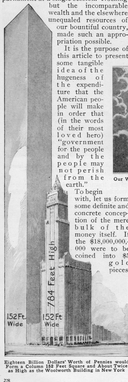
    The February 1918 issue of Popular Mechanics presents an unusual graphic display of quantitative data–what the $18,000,000,000.00 that the just-ended session of Congress for war expenditure would look like if rendered in different forms, and also what it would buy.  The author of “Visualizing the $18,000,000,000 War Fund for for 1918”, Leslie Klug, was trying to put that enormous sum into perspective for the popular reader–the results though may have been a little more mystifying than the sum. For example, he stated that $18bn in $5 gold pieces placed face-to-tail would stretch 3,000 miles; if that amount was rendered in pennies, it would form seven lines of coins from the Earth to the Moon. That penny pile would also be thicker and about twice as high as one of the world’s tallest skyscrapers, the Woolworth Building.  

    Billion planes961

    It is doubtful that this would help the Average Person understand $18bn, mainly because there isn’t much to compare a penny skyscraper with.

    The author seems to have replaced one semi-incomprehensible number with its representation in something even more removed from daily life, re-equating the one big sum of $18bn into smaller but more numerous chunks of the same figure.

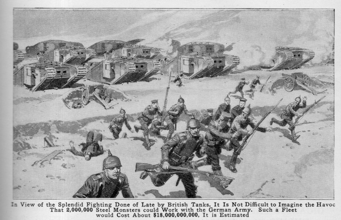
    Klug moves on to a more successful visualization–thinking of what that money would buy in planes and tanks.

    Of course the allocated war money was allocated to fund the entire war effort, including, well, everything, and not to be spent on one thing, like planes.  But Klug does create at least two visual images that  hadn’t occurred to me before–super-massive numbers of planes and tanks.

    “Massive amounts” of tanks in my head has always been represented by the Battle of Kursk, fought in the summer of 1943, where the tide of the war was changed and the German offensive in the East broken. It was also the largest tank battle ever fought. It was an enormous victory for the Soviet Army, and the beginning of the end for the Nazis. 4,000,000 people were involved in the battle (with some 200,000 residents of the city of Kursk killed in the process), along with 70,000 artillery pieces, 14,000 aircraft, and 23,000 tanks.  Klug informs the reader that $18bn would buy 2 million tanks–he can imagine the “havoc” it would cost the Germans, but really doesn’t even try to imagine what 2 million tanks would look like, unlike the penny cables to the Moon  And the illustration really doesn’t do any sort of job in displaying the idea of massive tank production, just a little touch of fear.  The 2 million tanks bit comes a little bit into focus if there was something to compare it with–the Kursk–even though trying to imagine that battle of tanks time 100 its accessibility really just begins to dissolve. 

    When I try to think of 2 million tanks in terms of a single advancing army the impossible numbers become slightly more grounded, but not much. A tightly-packed square mile of tanks numbers about, say, 90,000.  That means that you could have a 22-mile long mobile front of tanks that was also one mile deep.  Ouch.

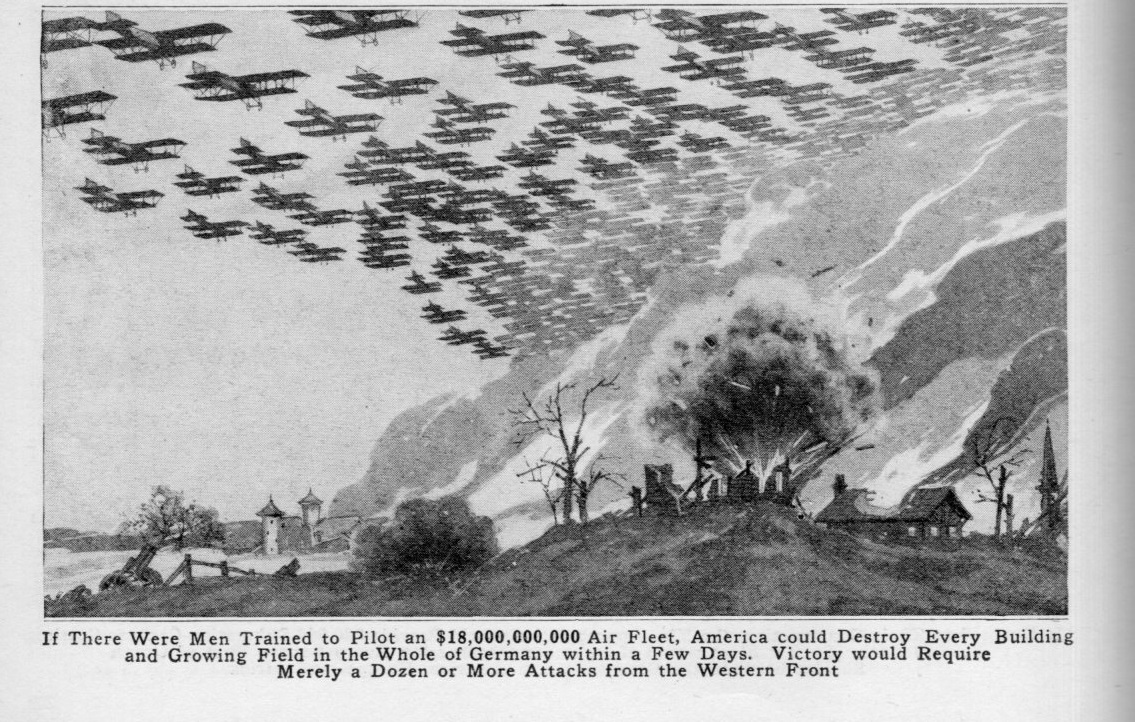
    Billion planes962

    Planes didn’t do the trick of conveying massiveness, either, though the illustration was a little more evocative of fantastic air power, though Klug doesn’t say how many planes the money would buy. The author does state that such an air power could destroy “every dwelling and planting field” in Germany.  (My guess is there could be 4-6 million aircraft purchased with $18bn.)

    Billion planes960

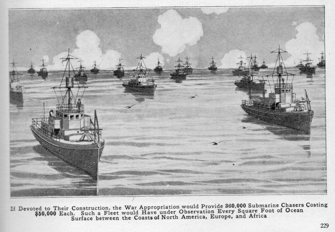
    Perhaps what seems what would be the most accessible of the visualizations comes with the navy, which would receive 360,000 “sub chasers” for the $18bn, a force which (Klug says) would be  capable of covering every square foot of ocean from North America to Europe and beyond–except that the numbers don’t work out.

    The North Atlantic is a big place, something on the order of 41 million square miles, which means that each of the sub chaser would have to cover 118 square miles to cover the ocean, which I think is impossible to do in pre-SONAR days of sub detection, when basically there was optical observation looking for a pipe sticking up out of the water.  I don’t know what the observational power is of a ship looking for a periscope in the ocean, but I know it can’t be the size of D.C. or anywhere near that.  How many ships would it take for this job would be an interesting tea-time question for someone who knows this stuff–but for me, it seems that Klug’s visualization on the naval aspect of  $18bn is wrong.  On the other hand that doesn’t matter at all if you’re doing a little propaganda write-up, like this one.  

    Billion planes963


    In any event that isn’t the way war expenses are handled, though it is a nice exercise in thinking about big numbers.  


  • How to Build a Living Flag Composed of 10,000 Sailors

    JF Ptak Science Books   Quick Post

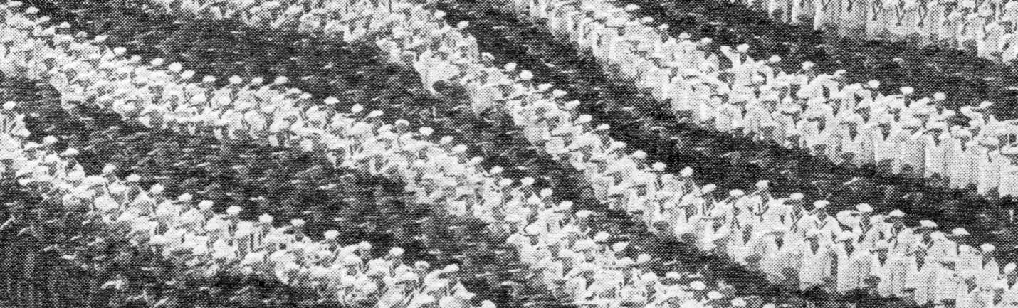
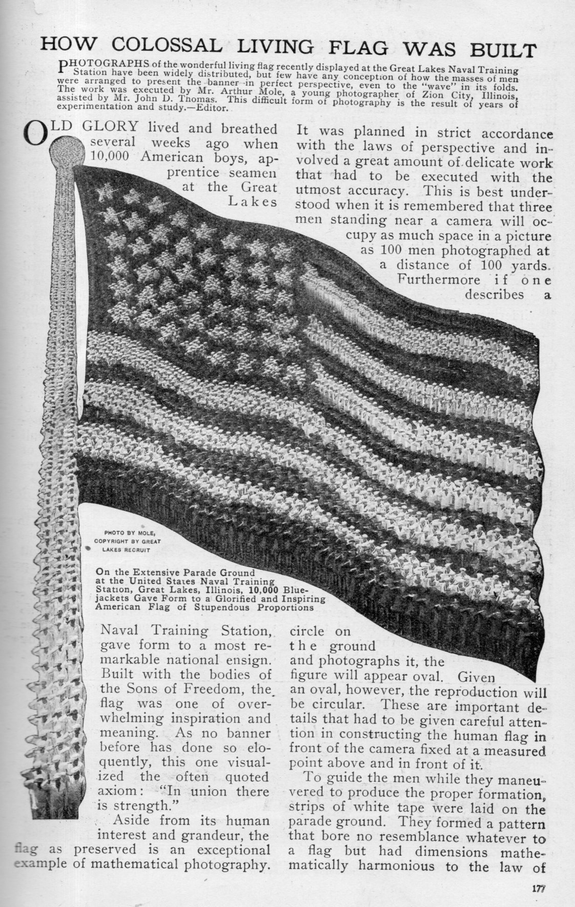
    This is an interesting display of perspective found in the article “How Colossal Living Flag was Built”, in  Popular Mechanics, volume 20, 1918, pp 177-8.  

    Measurements:

    • Staff on left: 550′ long, composed of 700 men
    • Ball on top of staff: composed of 250 men which measures 237′ x 20′ (and its widest as an oval)
    • Top of flag :293′; Bottom of flag: 73′
    • Left part of flag: 428′; right, 128′
    • Star upper left composed of 126 men; star bottom right, 12 men. 

    Flag massive958

     Oh–and according to the text, the shot took one hour to assemble.  

    Flag massive957


  • On the Color of Martian Water and Foliage, 1879

    JF Ptak Science Books    Post 2454

    • “The color of the water on Mars appears then to be same as that of terrestrial water…”  –Camille Flammarion, Scientific American Supplement, May 10, 1879, pp2787-2788
    • Image source: Google books, where the full text of the article is available. My own copy was simply too large for scanning.  
    • The original weekly issue of Scientific American with this article is available for purchase via the blog bookstore, here.

    I found this interesting map of Mars in the May 10, 1879 issue of the Scientific American Supplement.  The partially-anonymous author straight-away makes a provocative claim, 

    “WHEN sixteen years ago I published the last edition my work The Plurality of Inhabited Worlds I did expect to see the speedy confirmation that the progress astronomy was to give to my essay by allowing us so speak to put our finger on the manifestations of life”

    and then spends the rest of the article supporting the reinterpretation of Mars as another Earth.

    This is hardly an early assumption of the provocative thought of life elsewhere in the universe–there are  a number of authors who have written on the topic, and for hundreds of years prior to this. (Conversations on the Plurality of Worlds by the wicked-smart aesthete Bernard le Bovier de Fontanelle was published in 1686–the year before Newton’s Principia–and elegantly argued for teh plurality of worlds and inhabited earth-like planets revolving around other stars, spread throughout the universe.  Cyrano de Bergerac, Christian Huygens, J.J.L. Lalande–with an interesting Christian-based pluralist argument for not restricting the glory of the Creator’s efforts to simply life here on Earth, and (later) David Brewster, each wrote convincingly on the prospect of extraterrestrial life.)

    The author of this article turns out to be Camille Flammarion, an abundantly creative writer and observer, perhaps not so well known today as he should or could be, a sub-Verneian astronomer/publisher/writer whose ideas did not make it much past the nineteenth century. (And perhaps he or the editors at the Scientific American felt it unnecessary to identify him except by the title of one of his books because he was so very well known at that point, being the author of 70 books and all, and also for being perhaps the most talented of pop-science writers.)  He does give us this map, though, and tries with a mighty effort to solidify the gauzy appearances of structure of the Martian surface.  He honors astronomers with the continents and oceans that he sees, and is far more universal/multi-cultural in his acknowledgement of scientific accomplishment. Here we see the oceans Kepler and Newton,  and seas of Hooke (somewhat surprisingly), and (Giacomo)  Maraldi (Italian, 17th c), and Huggins, Maedler; and land masses of Copernicus, Galileo, Herschel, Cassini, Tycho, Laplace, Huygens. This version of the map comes 14 years after Proctor’s first attempt at a Martian map1 (and evidently the first map of Mars with a precise nomenclature) and which itself came another 25 years after the first first map of Mars by Wilhelm Beer (1797-1850) and Johann Heinrich Mädler (1794-1874).    

    Flammarion makes a strong case for life on Mars even without evidence, or at most the scanty suggestion of scientific proof, which is perhaps one reason why his brand of scientific adventurism and speculation didn’t survive into very much of the 20th century. Here are some examples from the article:

    “Can there be red meadows and red forests up there? Can it be that trees with foliage offer a substitute there for our quiet and delightfully shaded woods and are our scarlet poppies typical of the botany of Mars?” 

    “Are we authorized create all these analogies?  In reality we see only red green and white blotches on the little disk of this planet. Is the indeed terra firma is the green really water and is the indeed snow In a word is this truly a world like our own?”

    The question is asked, and then answered immediately in the next paragraph:

    “Yes!  Now we are able to assert it. The appearance Mars varies constantly. White spots move about over disk too often modifying its apparent configuration spots can be nothing but clouds. The white spots at increase or diminish according to the seasons like our terrestrial circumpolar ice fields which would precisely the same aspect the same variations to an placed on Venus…”

    Elsewhere in his Celestial Wonders, Flammarion writes: “The world of Mars is so much alike the world on Earth that, had we traveled thither someday and forgotten our route, it would be almost impossible for us to tell which of the two is our native planet. Without the Moon, which would mercifully relieve our incertitude, we would run the enormous risk of calling upon the natives of Mars while assuming we have landed in Europe or in some terrestrial neighborhood.”

    Notes:

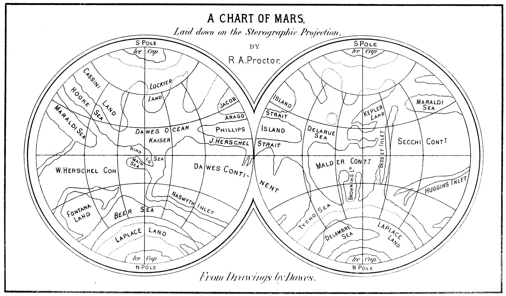
    1. The Proctor Map of Mars

    Mars Proctor 1868

    [Source: Wiki, here. R.A. Proctor: Other Worlds than Ours. London, printed in 1870, page 94.]

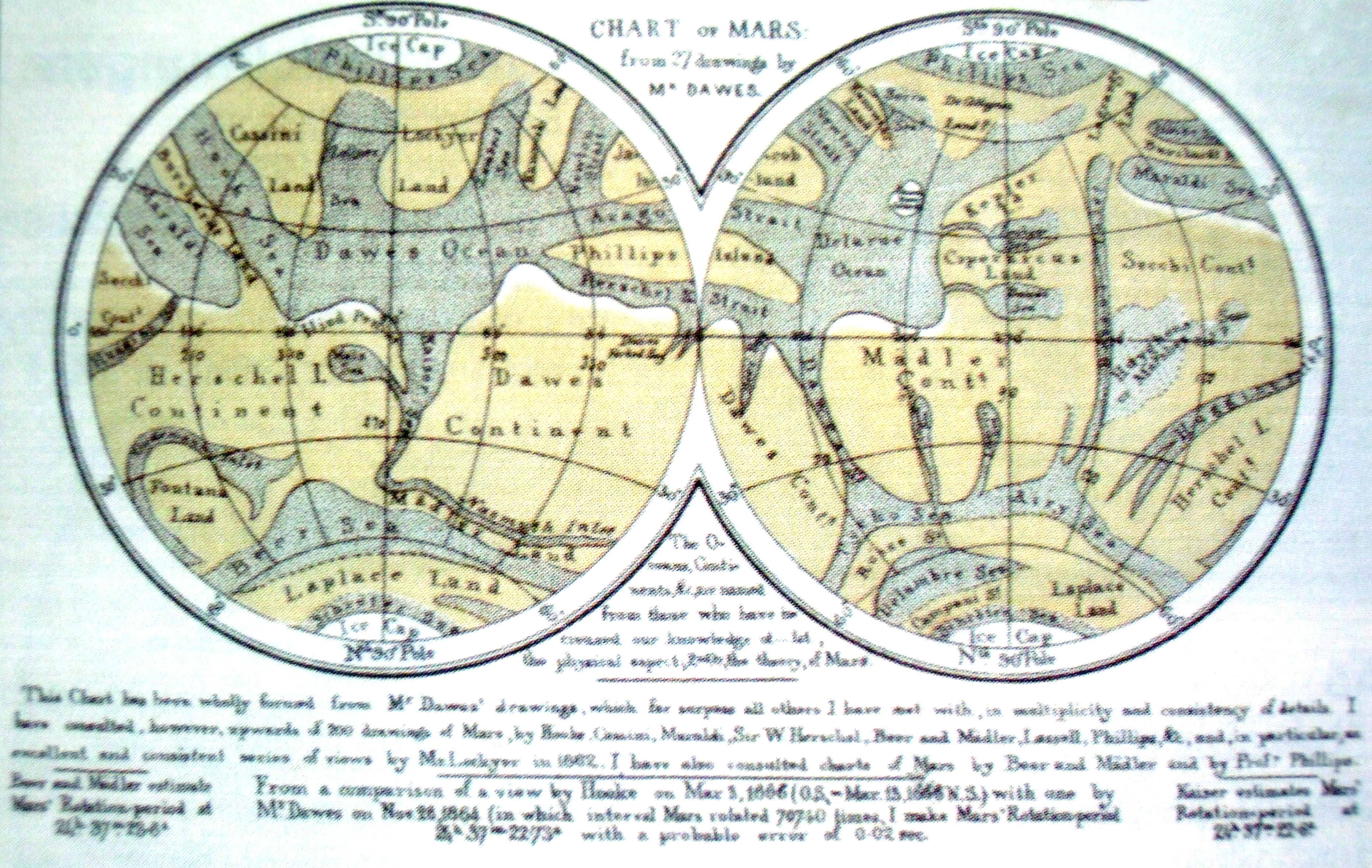
    The Proctor map was in turn based upon earlier work by Dawes:

    Mars Dawes

    [Source: Planetologia, http://planetologia.elte.hu/ipcd/proctor_1865.jpg  And in general see this link for much more in-depth appreciation and history of the Proctor map.]


  • Hot Bunks and Cool Air in (All White?) Community Fallout Shelters

    JF Ptak Science Books  Post 2453

    I will not go down under the ground
    Because someone tells me that death’s comin’ round;
    I will not carry myself down to die
    When I go to my grave my head will be high —

    CHORUS:
    Let me die in my footsteps
    Before I go down under the ground.–Bob Dylan, “Let Me Die in My Footsteps”, 1962

    Why they were more often called “Fallout Shelters” and not the more demonstrable “Bomb Shelters”? I suspect that was so because the former implies that unless you’re a corpse or incinerated that you’ve survived the initial blast and concussion and fire and firestorm of swirling sharp trash and now need to come to grips with the blast’s aftermath, so “fallout shelter” it must be.  

    And in the many pictures and plans for survival pods that I have seen I cannot recall one that included a non-white member of the community. The maps I’ve seen showing locations of fallout shelters for Manhattan have a smattering of shelters at the top of Central Park/110th St, but not all that many for Harlem. (I’ve never seen an official map of the placement of the shelters, just reconstructions thus far.) No doubt there were many shelters in Harlem–I just don’t know how many or in what regard they compared to other areas downtown  for percentage of people who could be accommodated. Perhaps a bigger and more obvious question would be what sort of rules there would be in the deep South for the use of shelters, and whether in 1962 if they would be segregated or not.

    • “If there are shelters in the black belt, no one knows where they are…” –Dr. Nathan Hare, “Can Negroes Survive a Nuclear War”, in Negro Digest, May, 1963, pp 26-33.  Full text at Afrocentric News, here.  

    This issue of LIFE magazine is a classic, with a number of pages and a few big image splashes dealing with the possibility of building mass  shelters for clumps of the population, preparing for the Soviets to start launching thousands of warheads our way. The people gathering here are remarkably calm, wearing sports coats and ties, and hats, with enough reserve to be holding the door open for the next person. Cars that pulled off the highway reacting no doubt to air raid sirens are neat and orderly, adding to the tidy and ship-shape scene that was so important to sear into the creative futuro-vision of Americans waiting for the Great Bad Thing to occur.  Images like this created the impression that no matter how many megatons could fall, there is a guy, in a hat, and coat, and tie, at the door, holding it open, for you.  

    Atomic bomb life mag cover

     [Source for this and for the image following all from Drexel University:  http://www.pages.drexel.edu/~ina22/+301/$301-texts-Life-shelters.html]

    Here’s an example of a calm, composed, considerate, commendable. concretized community, enjoying their ample and regulated spacing, hanging out and waiting to not-die:

    Atomic shelter LIFE community

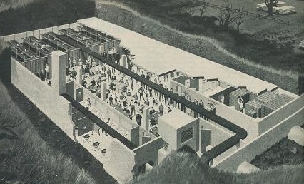
    “A WELL-PLANNED COMMUNITY SHELTER: Neat concrete box, reinforced and buried under earth or a highway, would reduce fallout radiation to a thousandth of that outside and would give occupants some protection from blast. Useful as a recreation or meeting hall in normal times, it could shelter 500 persons in event of attack. Stocked with food, water. first aid and sanitary equipment, it also has ventilating system to draw fresh air from filtered intake (center foreground). A source of oxygen not dependent on outside air would give protection against firestorms. Space-saving tiered bunks rely on “hot bunk” system, with sleepers taking turns.”  LIFE magazine, January 12, 1962

    Some people were asked in a man-on-the-street fashion about shelters–this barber thought it was a money scam:

    Atomic bomb shelters cabbie

    And this cabbie thought that if he couldn’t ride out The Big One in his basement, then, well. “the hell with it”:

    Atomic shelter cabbie2

    I’m pretty much okay with both of these guys.


    ·Posted by :

    ·in:


  • Bombing Subs with Exploding Birds, 1918

    JF Ptak Science Books    Quick Post

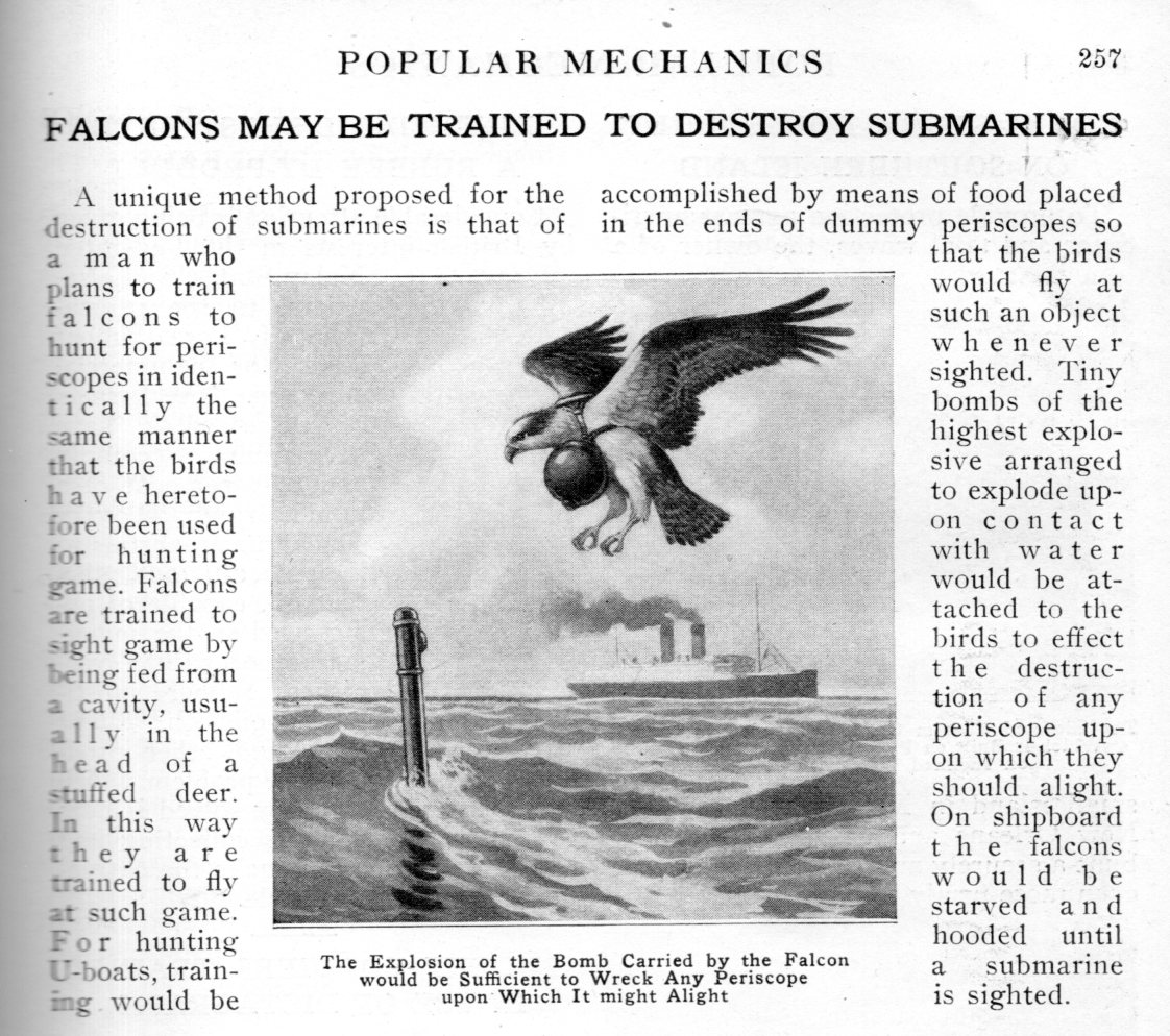
    This title sounds a little stretched and disingenuous, but it is not, not really–there was a plan to destroy periscopes of subs, rendering them ineffectual while submerged, and it did involved exploding birds, so the title to this quick post is largely true.

    The article/note explaining it all appeared in the February 1918 issue of Popular Mechanics, which is reproduced here in full. It is brief and to the point: a falcon would be trained to hunt a metal tube protruding from water, which is would attack while carrying a pouch of high explosives around its neck that would detonate when it came into contact with water.  No more periscope, no more sub, no more falcon.

    Exploding falcons956

    It does seem to be a wooden-cog reaction to a metal gear problem…and very off-putting.  

    I haven’t seen very many bits on using animals as actual weapons of mass destruction, though the ones I recall catapulted diseased animals over and into enemy lines, and a few other truly bad things not worth repeating. But I must say that I found this approach to warfare particularly repugnant, even for warfare of desperation.  

    ·Posted by :

    ·in:

    —

  • Atomic Explosion Tourism

    JF Ptak Science Books   Quick Post

    Part of the series on the History of Atomic and Nuclear Weapons

    I am certain that in all of the posts I’ve made in this blog that I’ve never considered atomic explosion tourism–vintage, semi-antique, see it-while-it-happened tourism.  I’m not talking about going out to the Jounada del Muerto to see Trinity, or taking a bus to Chernobyl, or checking out the sites ad the corner of Trinity and Oppenheimer, as we would now–but witnessing an actual explosion, then.  And there were plenty of opportunities to witness one, especially if you were in Vegas,and more so if you took the trouble to disrupt your activities to search for the mushroom cloud rising 5 miles away.  

    And in the case of the leaflet below, you could take a bus for three bucks and have a clearer view of the detonation.  

    Just be sure to remember your tie.  

    Atomic bomb tourism det


    Atomic bomb tourism[Source: Nevada Public radio, KPNR–see here for a few more examples.]

    ·Posted by :

    ·in: