A Daily History of Holes, Dots, Lines, Science, History, Math, Physics, Art, the Unintentional Absurd, Architecture, Maps, Data Visualization, Blank and Missing Things, and so on. |1.6 million words, 7500 images, 4.9 million hits| Press & appearances in The Times, Le Figaro, Mensa, The Economist, The Guardian, Discovery News, Slate, Le Monde, Sci American Blogs, Le Pont, and many other places… 5000+ total posts since 2008.

Author: JF Ptak

  • Japan Attacks L.A. (and the Rest of Us) in 1937

    JF Ptak Science Books  Post 2573

    Earlier in this blog I posted about an article that appeared in Life magazine on the various invasion/attack routes on the United States in 1941. (I believe this was the most visited of all 4000+ posts over eight years, with something on the order of 200k visits.) It came to mind while I was working my way through the P.J. Mode Persuasive Map Collection (digitized) at Cornell University and found this glorious appraisal of the possibilities of a Japanese attack on Los Angeles and the western U.S. It screamingly appeared in the Los Angeles Examiner on November 7, 1937  (p. V-8), and no doubt was meant to incite some sort of thinking in the paper’s reading population. (I don’t think it a coincidence that California is shown in yellow in the details when under attack and blue before being attacked.) Remember that the Japanese had already been mucking around in China for several years and the (Second) Sino-Japanese War was already full-on for a year by this point, so giving the possibility of Japanese imperial designs on the U.S. in 1938 is not necessarily so far out of reach.  (On the other hand many of the high command in Japan thought it a miserable and in some cases an insane idea to finally attack the U.S. in 1941, so there’s that–plus there’s the larger and more substantial issue of the incredible amount of ships and planes and support and energy that goes into manufacturing an invasion of this scope that would just be out-of-hand for Japan.) All that said, it is an interesting to see this play out in the pages of the Examiner.

    • Mapping the Invasion of America, 1942  https://historyofideasblog.com/thesciencebookstore/2009/12/mapping-the-invasion-of-america-1942.html
    • Invasion Routes to the U.S. 1940  https://historyofideasblog.com/thesciencebookstore/2011/06/invasion-of-the-us-1940.html
    • The Invasion of America, 19?? (1935) https://historyofideasblog.com/thesciencebookstore/2010/01/the-invasion-of-america-19-1935-scenario-for-invasions-via-canada-mexico-and-the-caribbean.html
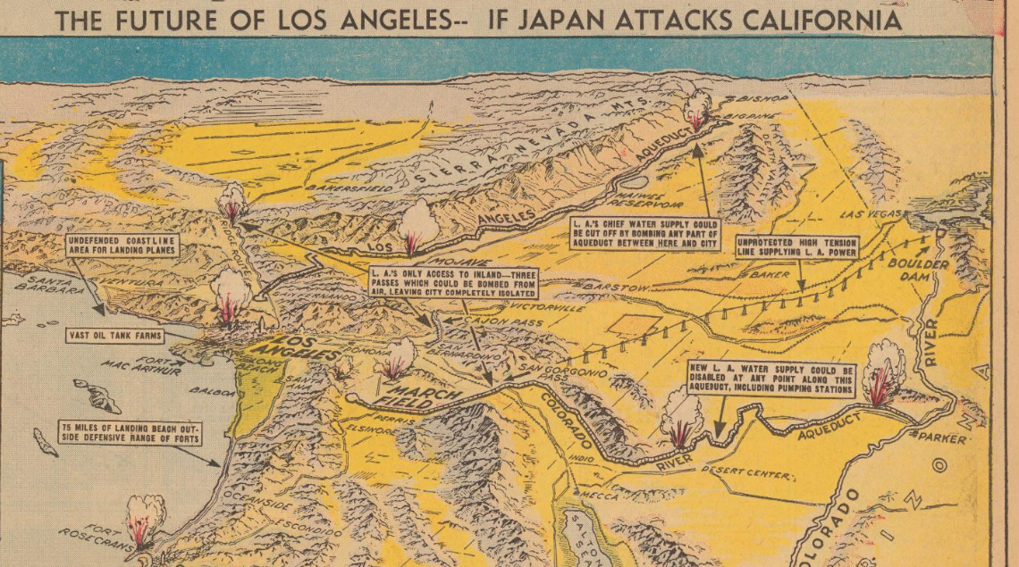
    Maps Japan attacks LA detail a[Source: PJ Mode Persuasive Maps Collection, at Cornell: https://digital.library.cornell.edu/catalog/ss:3293952]

    And the vision for San Francisco:
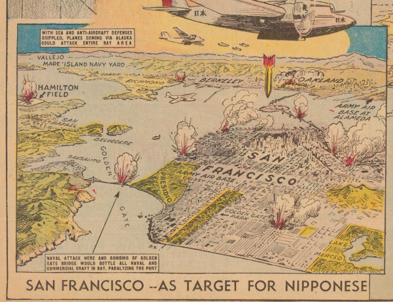
    Maps Japan attacks San Fran
    [Source: PJ Mode Persuasive Maps Collection, at Cornell: https://digital.library.cornell.edu/catalog/ss:3293952]

    And the full page, showing the importance of the Aleutians to the general plan:
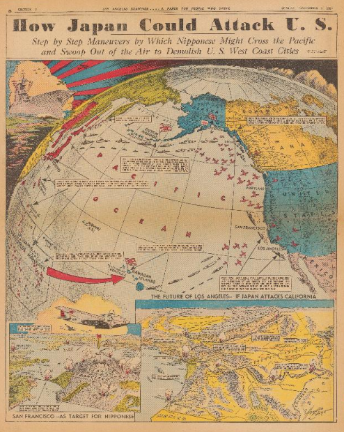
    Japan attack US[Source: PJ Mode Persuasive Maps Collection, at Cornell: https://digital.library.cornell.edu/catalog/ss:3293952]
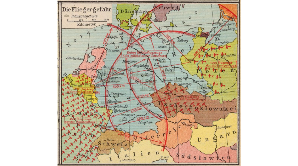


  • Propaganda Maps Showing Threats to Hitler’s Germany, 1930’s

    JF Ptak Science Books   Post 2572

    Maps air raid 1936 detail

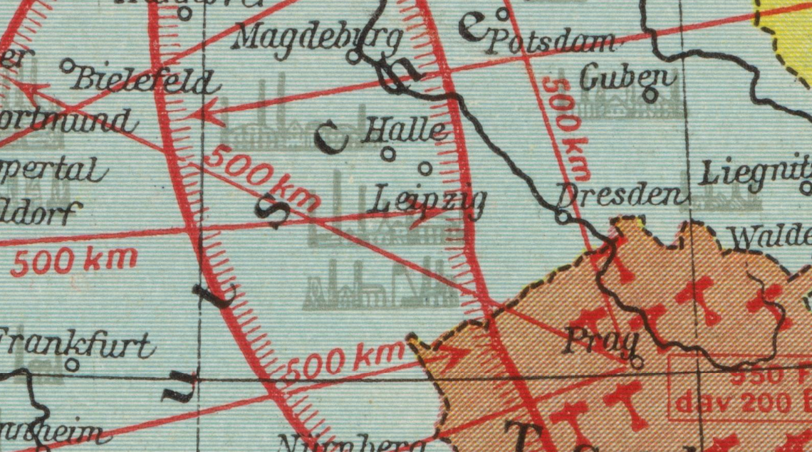
    I’ve found another example of map/propaganda display of the-threat-against-Germany in the between-the-wars period, this one published in  a very popular historical atlas by F.W. Putzger (Putzgers historischer Schul-atlas). The find comes in the fabulous “Persuasive Maps” collection of P.J. Mode (and housed and presented now at Cornell University, the source for the detail above and the originating image below) and supplements some earlier posts I’ve made to this blog on perceived and imaginary air and ground threats to Hitler’s Germany. These images no doubt gave pause to their viewers, driving home at least the need for building up “defensive” military responses to the threats posed to Germany.  In the top image the possible invaders of Germany are shown only in terms of airpower, depicting the range of the bombers and their country of origin, as well as the major cities that could be affected by such sorties.  No doubt the intent was to riddle Germany with as many red lines as possible, creating a morass of invasion and destruction possibilities, so much so that you have to look with a little discernment to see the city names under the limit lines.  It is a strong message, especially considering that in this case at least the audience was upper-level school children, and given that it appeared in an historical atlas the image was given that much more credibility and further entrenched a duck-and-cover mentality in its young viewers.  


    Maps air raid 1936

    [Image source: P.J. Mode Colelction at Cornell University, https://digital.library.cornell.edu/?page=18&q=persuasive&search_field=all_fields&utf8=%E2%9C%93&view=gallery]

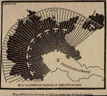
    As I said this map is a good supplement to other similar efforts that have appeared in this blog. For example, in continuing the heavy-lines-obliterating-Germany design is this earlier (1933) map showing the range of the air force of Czechoslovakia:

    [See https://historyofideasblog.com/thesciencebookstore/2010/10/nazi-propaganda-germany-surrounded-1933.html]

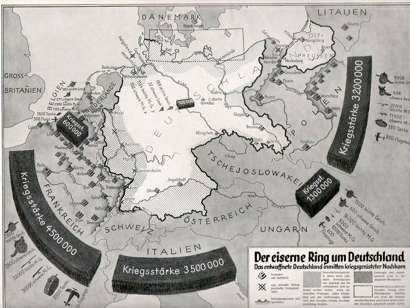
    And this fantastic effort (“The Iron Ring Around Germany”) showing the general possibilities of general attack against Germany:

    Nazi Prop surrounded538

    [See https://historyofideasblog.com/thesciencebookstore/2010/10/nazi-propaganda-germany-surrounded-1933.html]

    Nothing quite rallies people to your side as the unifying response to a perceived national threat


  • Unusual WWII Maps by a Significant Soviet Intelligence Agent

    JF Ptak Science Books  

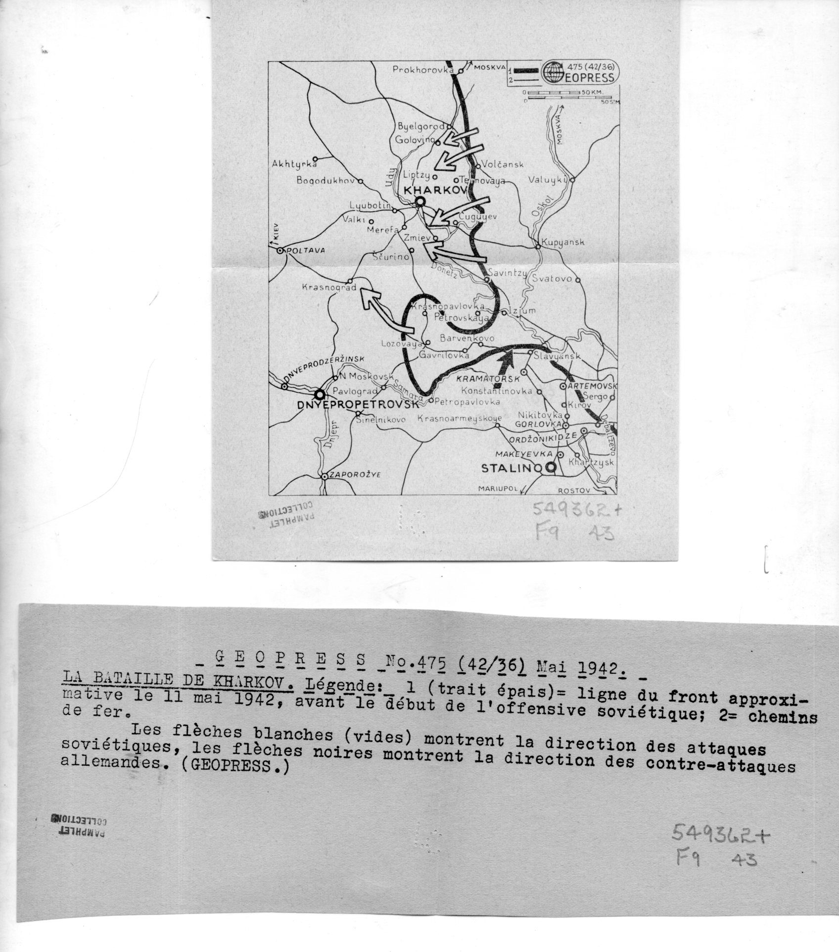
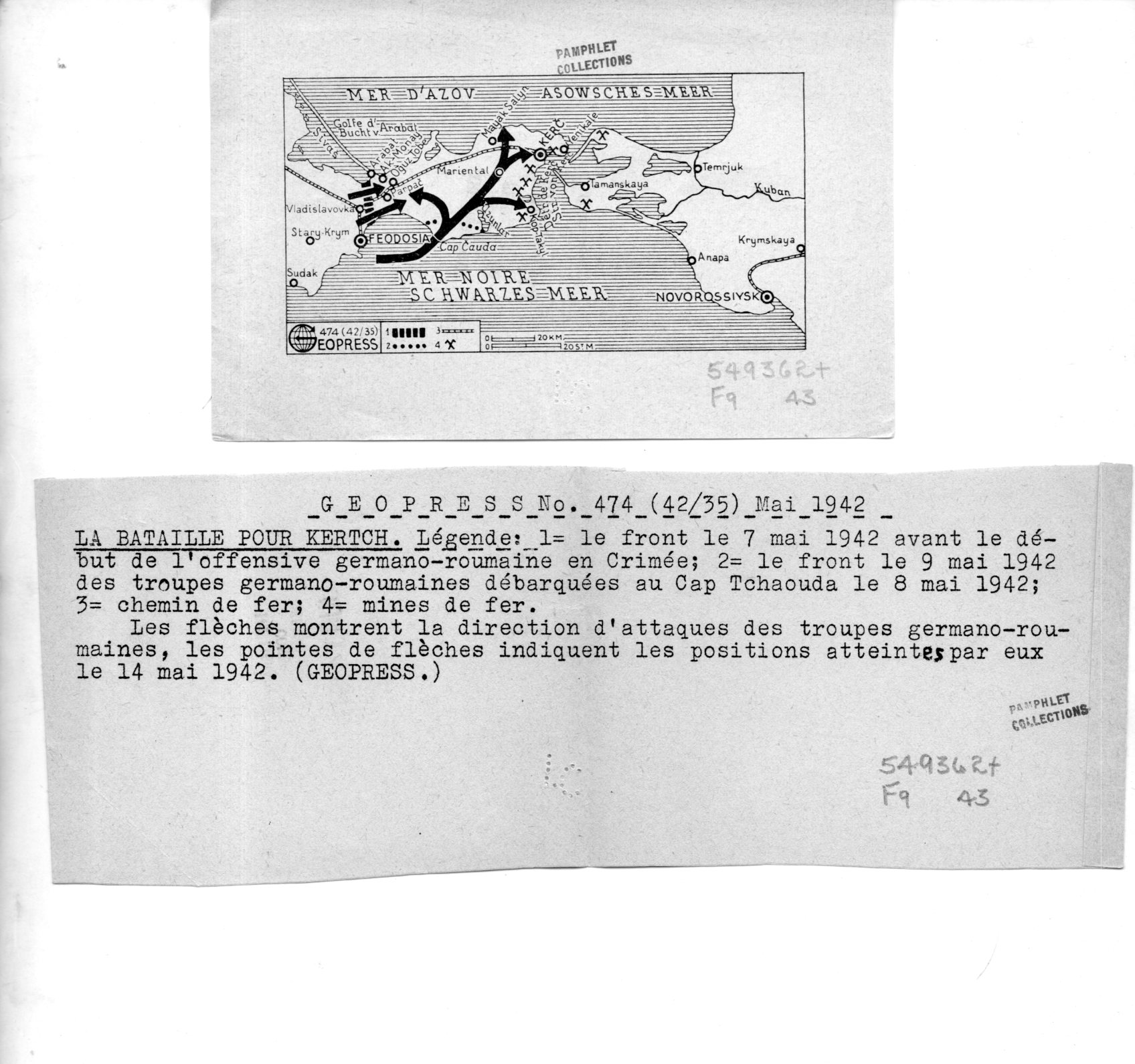
    I’ve found a number of interesting maps in the pamphlet collection here–these are highly unusual to my experience in that they were the work of a firm called “Geopress”, which was an active business and cover for a significant intelligence agent for the Soviet Union, operating in Switzerland, collecting data relating to German activities during WWII. There’s nothing I can add beyond the information that I quote extensively below from the CIA website on Rado–except that I cannot find images/examples of his Geopress work. So it seems the most efficient thing to do here is to simply quote the known sources and reproduce the images of the 18 maps and their accompanying texts.  

    Geopress _4_080

    As I said Rado operated Geopress as a news/cartographic service, and Rado was an accomplished cartographer, so the mans in and off themselves as maps are perhaps not a singular issue.  Their evident scarcity, however, does seem to be an issue. Also I do not understand why these maps are so small, some of which are just 1″x 3″; also the uneven;y cut/torn text sheets that are made to accompany the maps are also puzzling in their own way.  I do not understand the format–someone out there in Weblandia no doubt will.  

    All of the maps shown below are from 1942. They were received by the Library of Congress in June 1943 and stamped so on the backs of the maps.  (They lived for some time in the “Pamphlet Collection” at the LC before being purchased by me in 1998.)  

    The following quotes come from the CIA website, the Center for the Study of Intelligence, here:  https://www.cia.gov/library/center-for-the-study-of-intelligence/kent-csi/vol12i3/html/v12i3a05p_0001.htm]

     “Alexander (Sandor) Rado, Alexander Foote’s chief in the Swiss-based “Rote Drei” net that in 1941-43 supplied Moscow with detailed information on German order of battle… His activity in intelligence, mapping, and related fields has lasted nearly 50 years and may earn him a place in the pantheon of major intelligence figures of the times.”

    And this:

    “In 1936 or 1937, with Soviet funds and having a Swiss citizen as silent partner, Rado organized Geopress, a news agency specializing as Inpress had in maps and geographic background data. Geopress was more successful than Inpress because of better organization and the increased demand for news maps in the advancing shadows of World War II. As cover for an intelligence operation it proved ideal. Its normal activity—news collection and dissemination—provided justification for contacts with businessmen, officials, diplomats, journalists, and military leaders, some of whom became intelligence sources. It also justified a large volume of telephone and telegraph traffic, extensive postal business, and the maintenance of a courier system.”

    And so:

    “While building up his Geopress cover Rado also developed his sources, organized communications, and summarized for transmission the reports collected by his growing network. And he even found time to maintain through publications his image as an internationally known geographer.”

    And:

    “24 Feb. 1945.  During the German occupation of Hungary, (Rado) lived in Geneva where (he) published geographical maps for the Allied Governments until 1943; discovered by the GESTAPO and consequently his relatives in Hungary were murdered/ went with family to Paris in September 1944 and continued his work/summoned to Russia to report on his activities with the Free French Organization and left on 8 Jan. 1945 by special plane for Moscow/suspecting a trap, he got off the plane in Cairo where he remained/received no news from his wife in Paris and suspects that she might have been deported/he was formerly a Fellow of the Geographical Society in London, New York, Paris, Geneva, Rome and Washington, D.C.  OFFICE OF CENSORSHIP, Egypt, 11 April 1945.”

    [Again, the source for this and the above quotes:  https://www.cia.gov/library/center-for-the-study-of-intelligence/kent-csi/vol12i3/html/v12i3a05p_0001.htm]

    The maps:

    Geopress _3_079


  • Maps of Torment: the U-Boat Menace, 1917/1918

    JF Ptak Science Books  

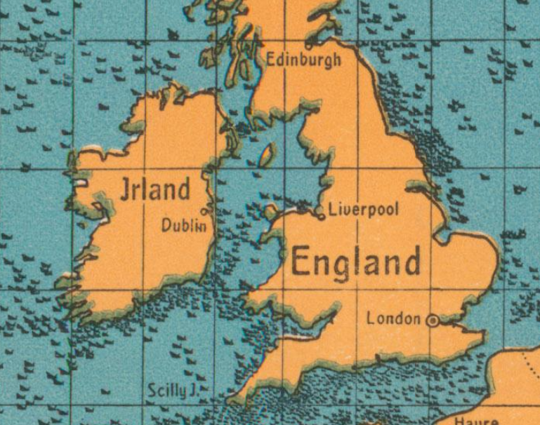
    This is a pretty stark reminder of just what was going on in the waters around Great Britain in 1917–it is a postcard propaganda map showing the gross tonnage of ships sunk by U-Boats for 1917:

    Maps U-boat WWI sinking

     [Image source: P.J. Mode’s wonderful collection of what he refers to as “Persuasive Maps”, now housed at Cornell University.]


  • An Unusual Chronological-Timeline-World Map (1887)

    JF Ptak Science Books   Quick Post

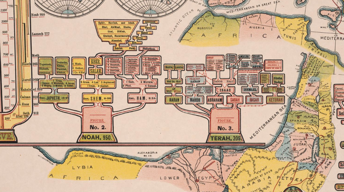
    The details of this chronological chart/map caught my eye–the genealogy trees look to me very out-of-place or -time, speaking in terms of design, and seem to have a definite mid-20th century feel to them:

    Maps dataviz chronology

    They are found in the left section of Jakob Skeen’ s 1887 Genealogical Chronological And Geographical Chart. Embracing Biblical And Profane History Of Ancient Times From Adam To Christ, which is part of my friend P.J. Mode’s wonderful collection of what he refers to as “Persuasive Maps”, now housed at Cornell University. I don’t often see chronologies of this detail with embedded maps, which is another odd bit about this display of information; overall, it is unusual to my experience:  


  • Some Vastly Creative Titles by S. Dali (1930’s)

    JF Ptak Science Books  Quick Post

    Love him or not, there seems to be little middle ground with Salvador Dali. What I find probably-peripherally interesting in Dali’s writings are the titles of them…maybe more so than the written piece itself–perhaps that is because I enter such deep shallow pool in them where I become lost or bored or just cleaved up in misunderstanding…it is all a possibility.  One thing that is inarguable I think are the titles of some of his works.  For example, I wanted to share a few that are found in the Surrealist-laden but not-necessarily-Surrealist art magazine, Minotaure (1933-1939):

    • “Non-Euclidean Psychology of a Photograph”
    • “The Spectral Surrealism of Eternal Pre-Raphaelite Femineity”
    • “First Morphological Law relating to Soft Structure”
    • “A Paranoiac-Critical Interpretation  of the Obsessive Image of Millet’s Angelus“
    • “Concerning the Terrifying and Edible Beauty of Art Nouveau”
    • “The New Colouras of Spectral Sex-Appeal”
    • “The Aerodynamic Apparition of Object Beings”

    The Guggenheim notice on the Minotaure: http://blogs.guggenheim.org/findings/minotaure-surrealist-magazine-1930s/

    ·Posted by :

    ·in:


  • Captain Marvel and the V-1

    JF Ptak Science Books  Quick Post

    Captain Marvel was once upon a time in the 1940’s a superhero more popular than Superman, though Superman is the obvious victor over time (and a long time at that). I don’t know what Captain Marvel is doing here hawking a paper punch-out flying “buzz bomb”, particularly since it seems to have been produced during WWII.1 It does seem unlikely to me that a flying toy modeled on the buzz bomb would be sold to kids during the war. After all, the “buzz bomb” was the German advanced weapon called the V-1, or Vergeltungswaffe 1, (“retaliation”, or “vengeance” weapon), or Fieseler Fi 103,  or Doodlebug, and was a flying bomb (on the order of a very primitive cruise missile guided by a gyroscope autopilot) launched against population centers in England by the Nazis during the June 1944-January 1945 period.  The bomb was about 27’ long and 17’ wide, weighed 4,700 pounds, and reached 400 mph with an 1,800 pound warhead.  Thousands of people were killed in the 8,000+ sorties of this foul-sounding beast–there was only a general sense of where it was going and where it might land, so the death and destruction it caused was indiscriminate.  Given all of this I’m assuming that the guesses on the year of production of this are wrong, and that it is a post-war bit, which would be in less bad taste than had it been actually produced in wartime.  It seems to me that most superhero/action hero types were busy punching Hitler or some such thing, and not selling a toy based on Hitler’s weapons when they were actually killing thousands.  In any event, I’m sharing this unusual image with its unusual story. 


    Buzz Bomb Capt marvel cover

    Notes:


  • Fistfights and Beggars: Found Street Life in Old Prints (1757)

    JF Ptak Science Books   Post 2570    Zoomology Series

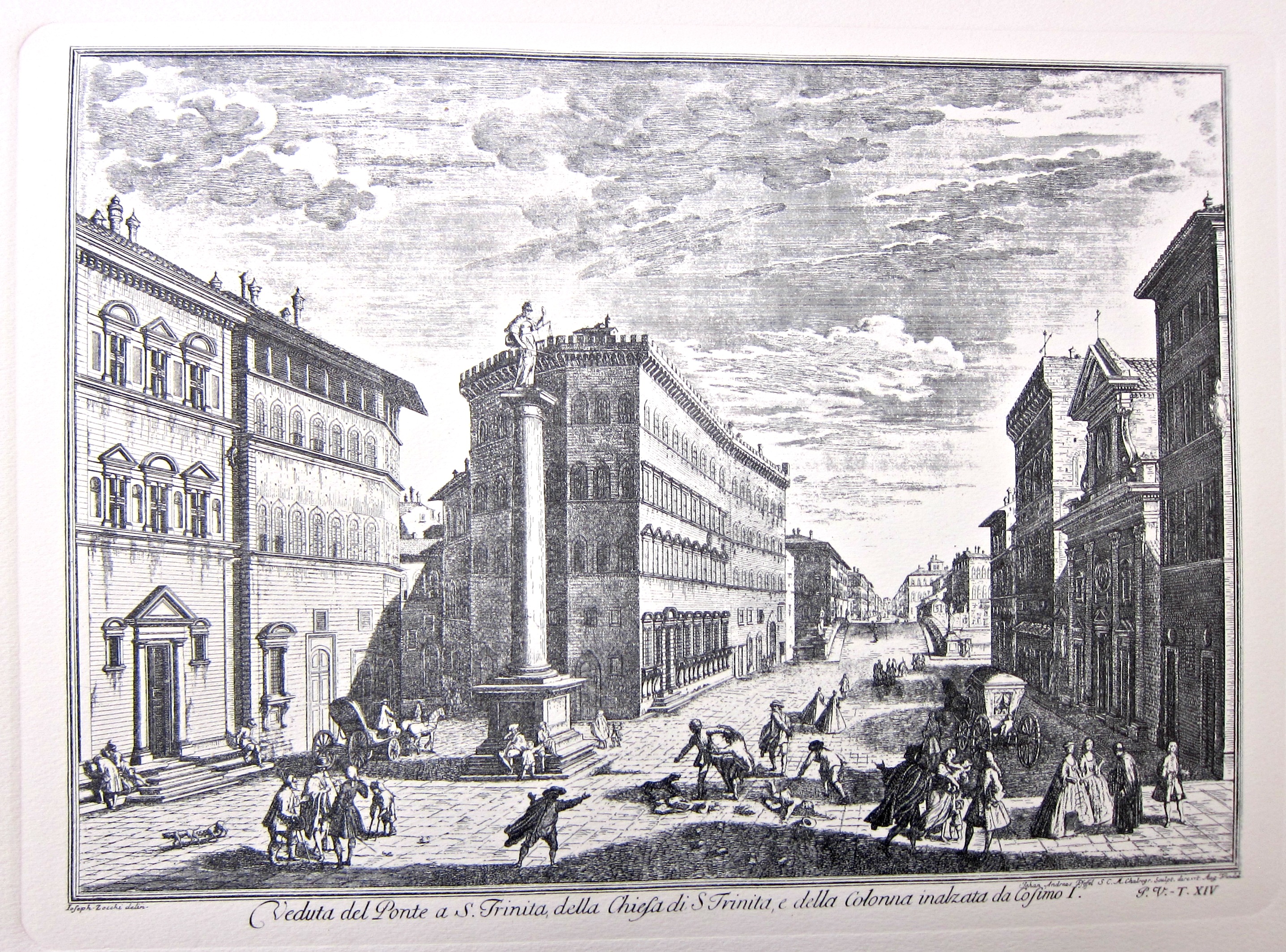
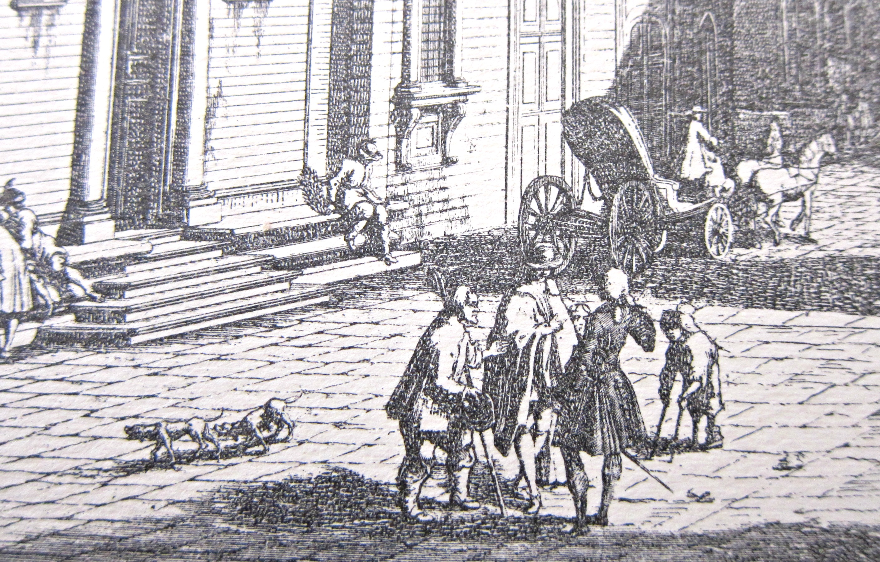
    I’ve written a number of times on this blog on using the “paper microscope” on finding small images hidden in plain sight within larger images in antiquarian prints. The image below is by Giuseppe Zocchi (1711-1767) (commissioned by the Marchise Andre Gerini at mid century to record the greatest of Florentine landmarks) and is entitled  “Veduta del Ponte a S. Trinita, della Chiesa di S. Trinita e della colonna inalzata da Cosimo I..” and appears in his Scelta di XXIV Vedute delle principali contrade, piazze, chiese, e palazzi della Città di Firenze in 1757.  The print displays the buildings and obelisk just down the way from the bridge whose name occupies the beginning of the image’s description, the ponte Santa Trinita, a fabulous renaissance structure built a hundred years earlier.  All we see of teh bridge though is is decking, though we do see a huge rise, which gives us a hint of teh bridge’s nature–it turns out that this is the oldest elliptic arch bridge in the world.  While the architecture is beautiful and teh perspective intersting, teh characters populzting the foreground are sometimes even more interesting. In general figures like this were used to take up empty bits of space and to provide perspective, and were depicted in the standard ways in which walking/riding humans are represented. In this case, however, there is a lot of social drama going on amidst the simple space fillers. 

    Zocchi d

     For example, in the bottom-left corner, we see doggies doing what doggies do, and also a disabled short person approaching a group of gentlemen in conversation:

    Zocchi c

    ·Posted by :

    ·in:

    —

  • The Pre-History of Imaginary Robots: Electric Deer, 1892

    JF Ptak Science Books    Post 2566

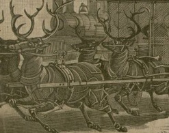
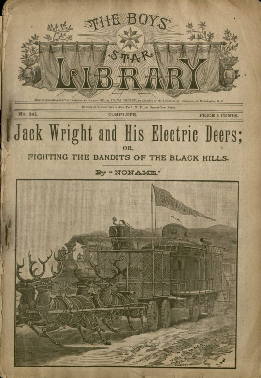
    Rebecca Onion at Slate Vault surfaced this very interesting image of electric breath on her twitter account (@Slate Vault), showing early robotic creatures alive and well and living in the minds of thousands of young kids, placed their partially by stories like this found in the pulpy pages of Frank Tousey’s Pluck and Luck in 1892. The image  (from the special collections library at the University of South Florida (here)) shows yet another work of genius/ingenuity by the endlessly adventurous “Jack Wright” a boy inventor, who seemingly went everywhere, did everything, and had the stuff to make it all happen.

    I’ve posted1 many times on this blog about 19th century imaginary robotics, and had not seen this Wright story and his fabulous “electric deers”. 

    Robot deer detail

    This Jack Wright adventure was written by “Noname”, who turns out to be by Luis Senarens (1863-1939)2, a very prolific and early sci-fi writer, a Brooklyn boy, who had been referred to as an American version of Jules Verne.  Senarens wrote beginning in the 1880’s and was no doubt much taken by the new applications of electricity, and Senarens applied it quite liberally. In a quick browse, he introduced electricity inventively, sprinkling it liberally over powered machinery and introducing his own electric ocean liners, submarines, sledge boats, canoes, air-schooners, locomotives, balloon ships, torpedo rams, horses, and no doubt much else. I’m glad to have caught up to Mr. Senarens’ robots.

    Robot deer

     Notes:

    1. Just search “robot” in the google search box at upper right.
    2. See the Edward T. LeBlanc Memorial Dime Novel Collection for very much expanded info on this and other series:  https://dimenovels.org/Series/734/Show

  • Earth Squared and Halved and Shrunken and Invisible and Doubled and Miniaturized

    JF Ptak Science Books   Post 1936 (expanded)

    This post is a part of overlapping categories, including:

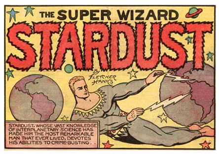
    Comics Hanks' double earthI don’t know if this is an actual Extra Earth that makes an appearance in a Stardust episode, or if it is just a repeated element of design–from what I have seen from Hanks, it could easily be either. 

    And now on the the rest:


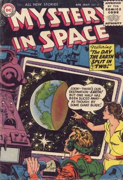
    Earth strange half earth

    In the eight years or so of collecting information and stories for the odd-bits section of this blog  I have never encountered so many choice visual examples in one place for strange/weirdly-imagined/impossible/high-SciFi of the Earth than with the comic book, Mystery in Space. The very dedicated keepers of Coverbrowse.com website have reproduced thousands (?) of covers of pulpily-published science fiction and exotic-thinking comics books, including the home base in which all sixteen-plus years of Mystery in Space live.