A Daily History of Holes, Dots, Lines, Science, History, Math, Physics, Art, the Unintentional Absurd, Architecture, Maps, Data Visualization, Blank and Missing Things, and so on. |1.6 million words, 7500 images, 4.9 million hits| Press & appearances in The Times, Le Figaro, Mensa, The Economist, The Guardian, Discovery News, Slate, Le Monde, Sci American Blogs, Le Pont, and many other places… 5000+ total posts since 2008.

Author: JF Ptak

  • A Lovely Printer’s Device Honoring the Sciences (1724)

    JF Ptak Science Books  Quick Post

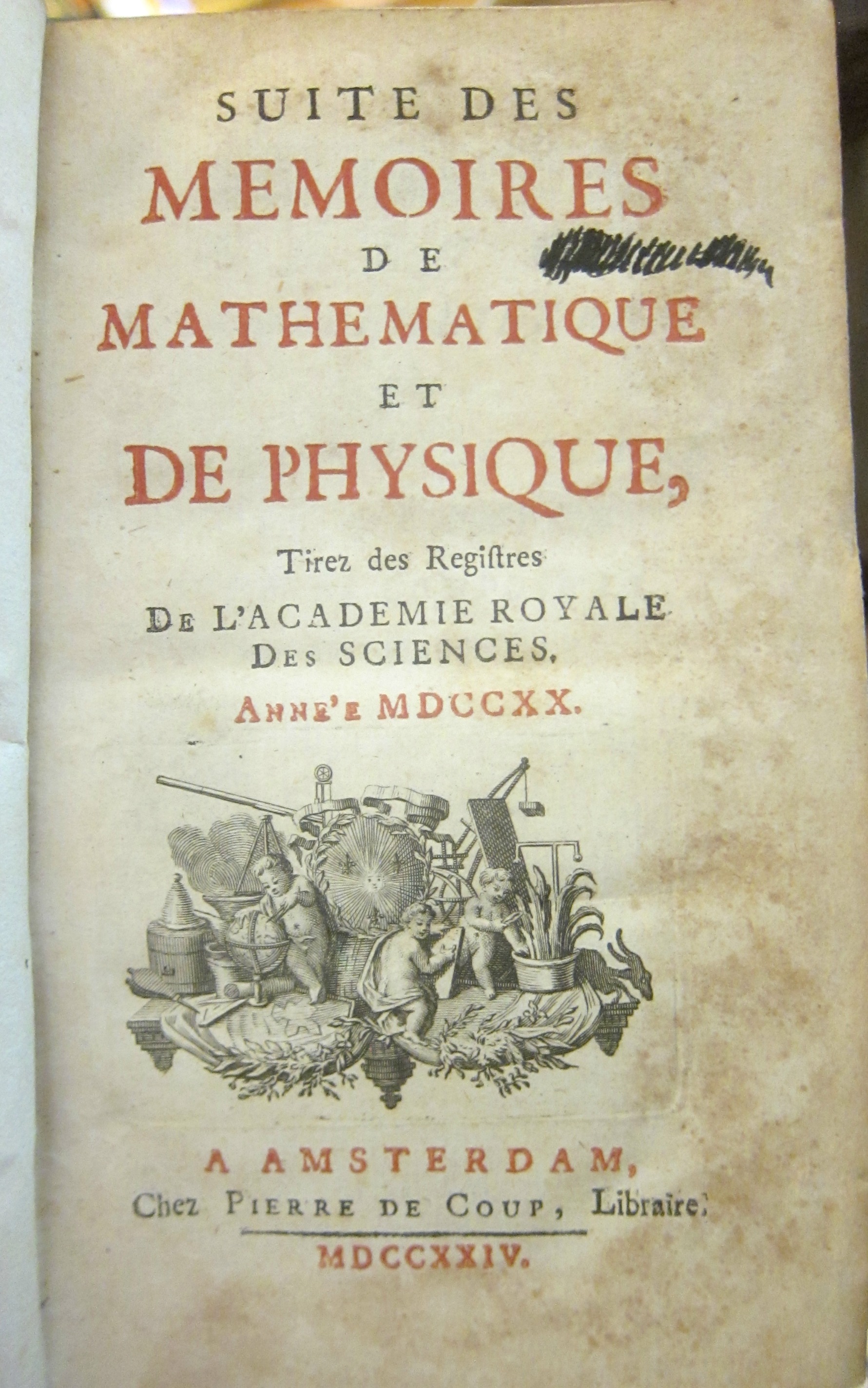
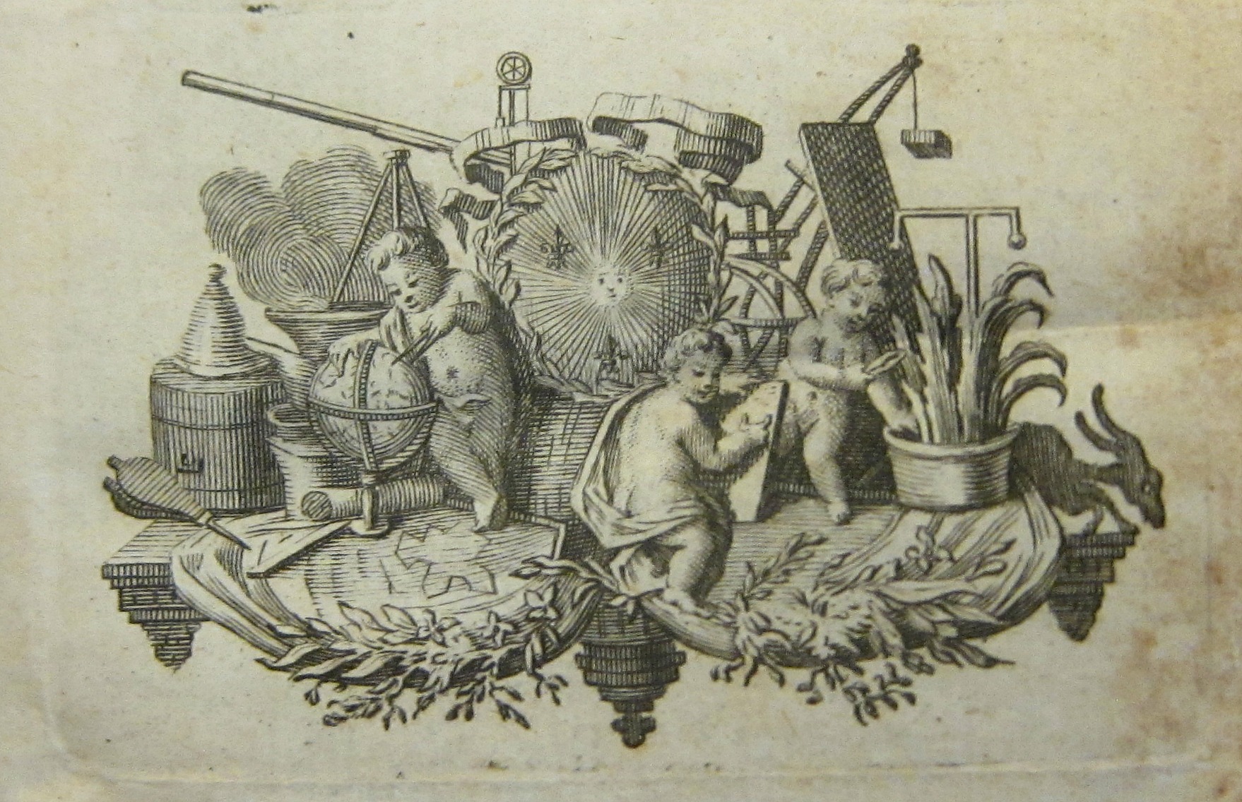
    Newly arrived here and new to my experience are some volumes of the journal Suite des Memoires de Mathematique et de Physique tirez des Registers d e l’Academie Royale des Sciences, a significant and beautifully-designed series of books which are small (only about 16cm) and very light, and their fine binding makes the book feel “correct” in your hands. I’ll be writing quite a bit about what I find in them over the next weeks and months, but the very first thing that stopped me was the scientific instrument-laden printer’s device on the title page–this the work of Pierre de Coup, of Amsterdam. The original is only about 3″ square (35x60mm), but it presents an abundant allegorical punch in a tiny space:

    Memoire de le Math


    And the full page:

     Memoire de le Math detail


    I can identify most of the instruments around the putti: right in the middle of it all is a crest with a blazing sun, no doubt indicating the reign of holy light on the impact of science and mathematics; to its rear and left is a telescope and to the right is a drawing table with a considerable balancing weight. One of the putti cuts a bit of the potted plant on the right, while another on the left works on a globe with a set of dividers (and may actually be standing on the plans of a fort).  The putto in the center (with an armillary sphere just behind him?) works on some sort of drawing, and looks down and away to the right. Additionally there are some bits an pieces: a right angle, a cauldron, perhaps an alembic, though I don’t know what that T-shaped instrument (on the right) is, or the clock-like-looking clock-like device at top-central…and I’m not sure why the bellows is figured so prominently (except for symbolic reasons). 

    For a full run of the journal see the Gallica site, here: http://gallica.bnf.fr/ark:/12148/cb32786820s/date


  • Octopusiana: the Failure of the Bank of the United States (the White House copy) 1931

    JF Ptak Science Books  Quick Post

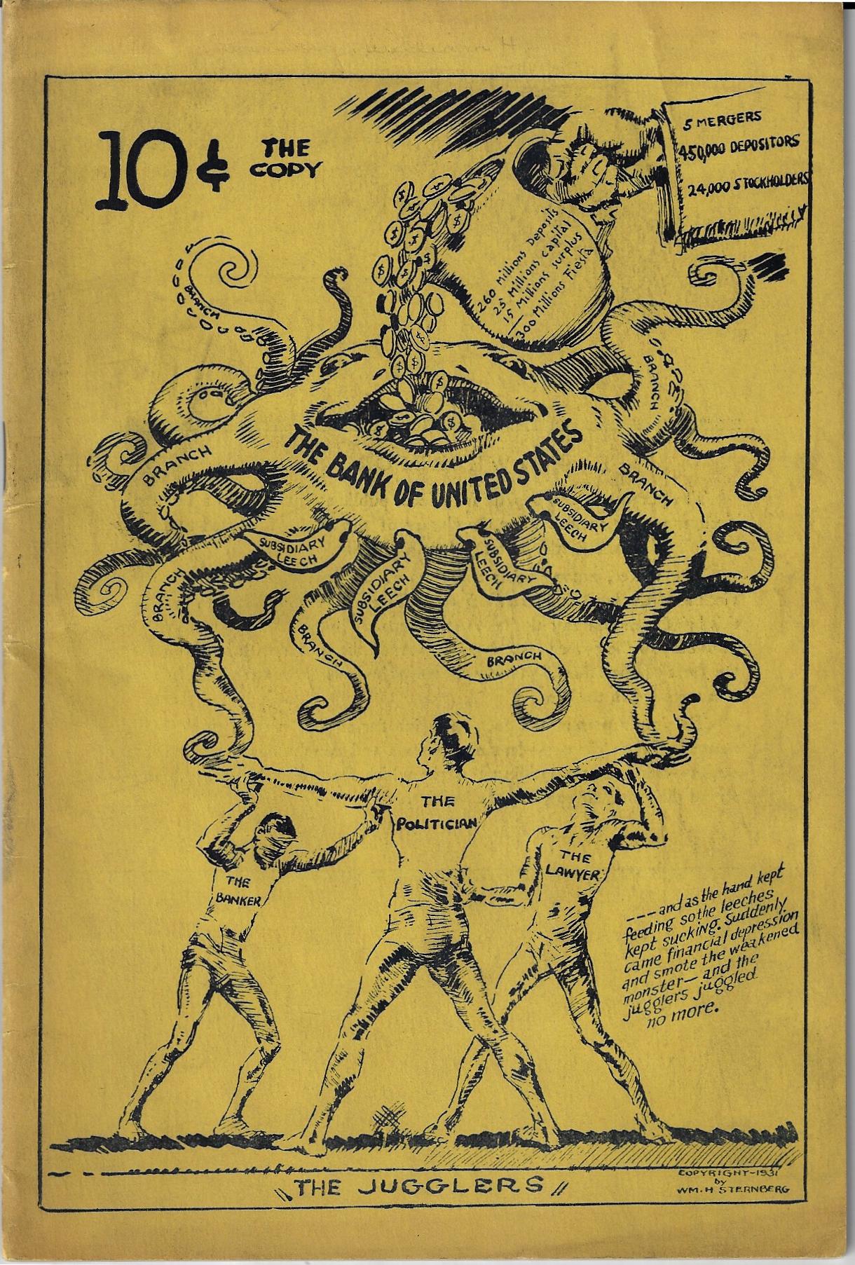
    Book cover octopus bankWilliam Sternberg.  Finis. The Bank of the United States, 1913-1930.  No publisher or place of publication listed, though copyrighted by William H. Sternberg, 1931, and “distributed ” by National Distributors. 23×15.5cm, 40pp. Highly decorated cover. Original wrappers.  Provenance:  the White House, and then the Library of Congress (stamped “by transfer/The White House, Jul 29 1931”. Very Good copy, with the LC surplus/duplicate stamp on rear cover, and a 6mm perforated “LC” stamp at the very bottom of the title page.  

    I was about to say that not many books have started their lives with the word “Finis” starting the title–a quick check in WorldCat has proved this wrong, as there at least hundreds of books with this word in the title. 

    The cover art–perhaps by Sternberg?–is very striking, and as with lots of political art, could be understood without having to read it, a glancing view being pretty much enough to tell the story.  The image features the Bank of the United States as a sort of 16-legged octopus, being fed money food from a merger/depositor pitcher, underneath which and perhaps keeping the whole thing afloat are a banker, lawyer, and politician. Sternberg evidently didn’t think much of the BOUS’ many acquisitions/mergers since it went into business in 1913, being particularly upset with the late 1920’s movements. Anyway this is a pretty screedy diatribe, though it also seems to be an informed one. 

    A Series of Unfortunate Events led to an infamous run on the BOUS’ Bronx branch, with 25,000 people showing up and wanting their deposits, all of which fed into the making of the Great Depression. The bank did not do well after the run.  

    ·Posted by :

    ·in:

    —

  • The Other Three German “B”s: Berlin, Barbed Wire, & Bayonets (1944/5)

    JF Ptak Science Books   Post 2700

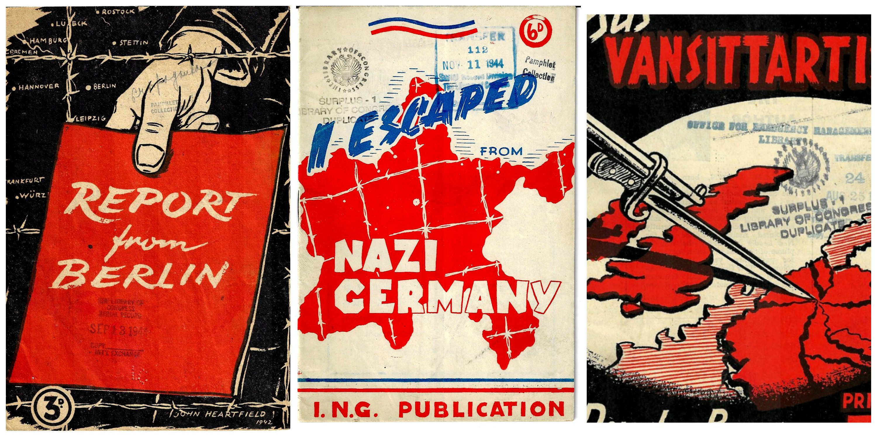
    There is probably no doubt that a lot of book and pamphlet cover art printed during the war would feature plenty of Berlin/Germany/Barbed wire/Bayonets and other sharp and pointed things leading their dagger-y way to the hearty of the country. I really hadn’t recognized it as a motif despite its pretty obvious design implications until I had three examples from my own collection right in front of me.  I’ve written about the first two on the blog before for various reasons unrelated to the sake of its design. The third, Report from Berlin ” by a German Communist” is something I thought I had addressed earlier but hadn’t, and presents a strong case in itself, as with the others.

    Germany 3 Bs


    The overall tenor in the pamphlet shows the position of doomed Germany from the inside out,  and starts the whole thing noting that “June 22 [1941] was the most fateful day in Germany’s history”, stating that “at 6 a.m.” Hitler gave a speech announcing the invasion of the Soviet Union, which the writer in 1942 finds the beginning of the end for Germany, and in this was mostly correct.  The author goes on to describe the food shortages, working conditions, morale and teh consequences of bombing, the fear and loathing of the secret police, and so forth.

    The “author” end of this equation is not clear: outside of “German communist” the writer isn’t explicitly identified. There is an “introduction” signed by Hans Kahle, who was a very prominent figure as an anti-fascist in the history of modern Germany, an impressive force, and he may well be the author of the entire text.  WorldCat/OCLC–which finds about ten copies of this work in libraries worldwide, and those mostly overseas–lists Kahle as an author, and then in another listing also lists the illustrator of the cover, the great John Heartfield, as an author as well. (Heartfield is remembered as with Georg Grosz as elevating the use of art as a political weapon, exercising it in both wars as well as the rise of Hitler and the National Socialists, and as a photo-montagist and Dadist.) In any event, the pamphlet was published by this German Communist whilst in exile in London in 1942, and was a general screed on the doomed damnation of the Nazis.  

    ·Posted by :

    ·in:

    —

  • Propaganda Maps–a Play for Greater Germany, 1938

    JF Ptak Science Books   Quick Post

    Maps Propaganda German speaking 1938

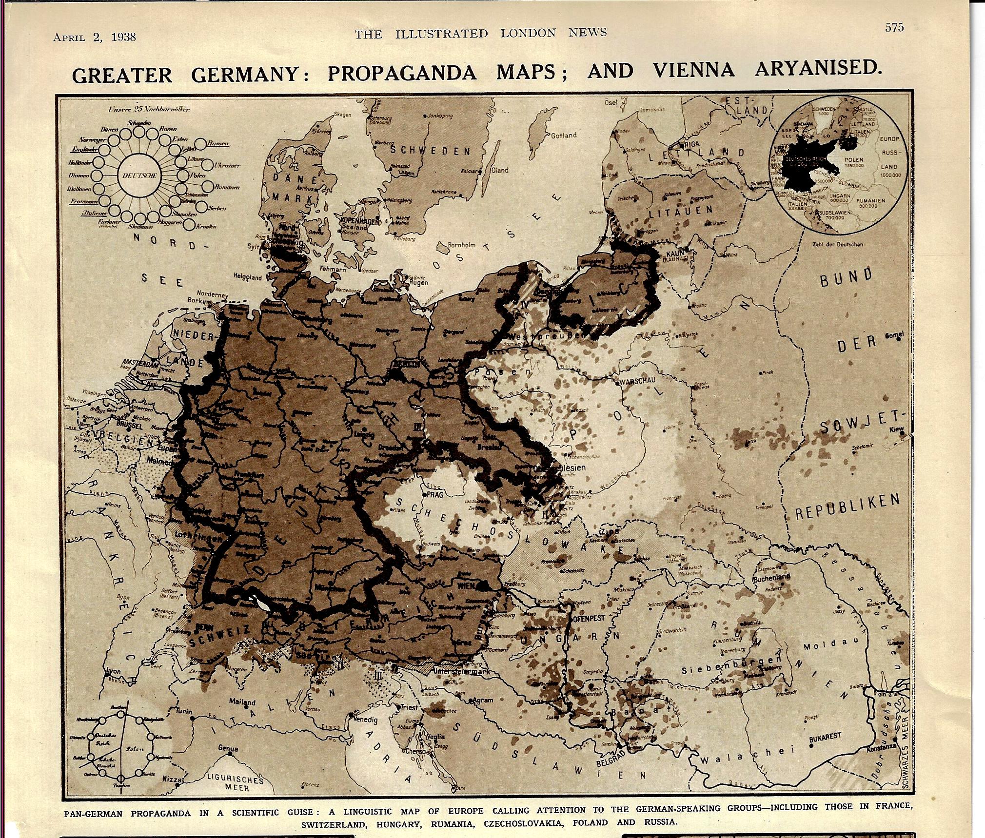
    [Image: The Illustrated London News, p 575, April 2, 1938.]

    The title and the date of this map pretty much tells at least the partial story of the beginning of WWII. The “Aryanized” Vienna (Wien) shows up with the rest of Austria as German-speaking but also outside the boundaries of Germany, even though the Anschluss Österreichs occurred about three weeks earlier. “Pan Germany” was still figuratively so, in spite of the absorption of Austria.  Prague sits nearly surrounded by Germania irredentia, and of course Czechoslovakia was next, with Germany beginning the theft of the country that October, and then only about a year after the appearance of this article, Hitler was giving a speech at Prague Castle, also declaring Bohemia and Moravia to be the Protectorate of Bohemia and Moravia. This linguistic map certainly portrayed the gaping maw of the Nazi Kraken, Germany declaring that these actions was a natural right in the protection of Germans-outside-Germany. 


  • Flat Out Wrong–Flat Earth, 1871

    JF Ptak Science Books  Quick Post

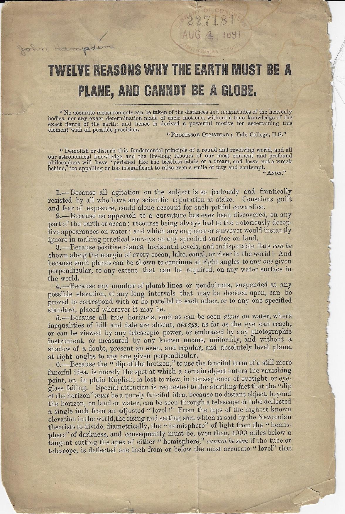
    John Hampden (d. 1891) was a fire-breathing Bible-literalist flat earther who rejected Newton & Co. at every opportunity and at all costs, doing as he was the work that the creator of the universe that he felt demanded of him. He famously feuded with the great Alfred Russell Wallace over a lost bet disproving the flat earth and pursued him via lawsuits and published vindictive. I don’t want to spend too much time with this, but I will reproduce below his leaflet missive advancing his theory, mainly because it looks as though it is pretty rare. It seems as though this was a separately-printed affair of his article that appeared in the rather bumpily named Weston-Super-Mare Gazette on November 11, 1871.  

    Flat earth _1_

    ·Posted by :

    ·in:


  • TubePunk–Electronics Returns from War (1946)

    Book covers electronics reutn from the war 1946JF Ptak Science Books  Quick Post

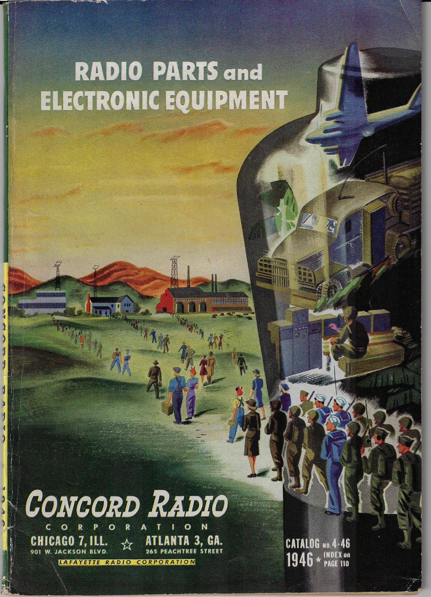
    Of the numerous things that “won the war” for the Allied forces–besides Churchill, and Roosevelt, and millions of Soviet soldiers, and Eisenhower, and V Bush, and cracking Enigma and MAGIC, and the enormous production capacity of the U.S., and so on–there was “also” the warm electrical/dusty scent of active vacuum tubes, which somehow always remind me of “precision”. The importance of RADAR I think cannot be overstated, plus SHORAN, and the Harvard Mark I, directional finders, and etc., all combined into a massive electronic war-winning effort that certainly helped define victory in WWII.  

    This is sorta what I was thinking about when I saw this lovely Concord Radio catalog for 1946–the enormous vacuum tube in which various military ops were happening, and then the troops marching out of it on the bottom, back into civilian life, carrying the promise of the new electronic world with them to home, industry, and business, and that electronics was here to stay.  Another “here to stay” thing here was the female worker–if you look closely at the crowds returning to their lives-left-behind there is no shortage of women, which I think was pretty progressive for 1946.  


  • Lubricating the Machine–a Map of Domestic Sewage (1892)

    JF Ptak Science Books   Quick Post

    You can’t have a Second Industrial Revolution without people living closely together, and you can’t have that without cities, and you have cities without water, and you can’t have any of that without a way of getting rid of the water and what all of those people were evacuating. And so the issue of “drainage” takes on a lot of powerful meaning–in getting rid of sewage, and rainwater, and a host of other things.  

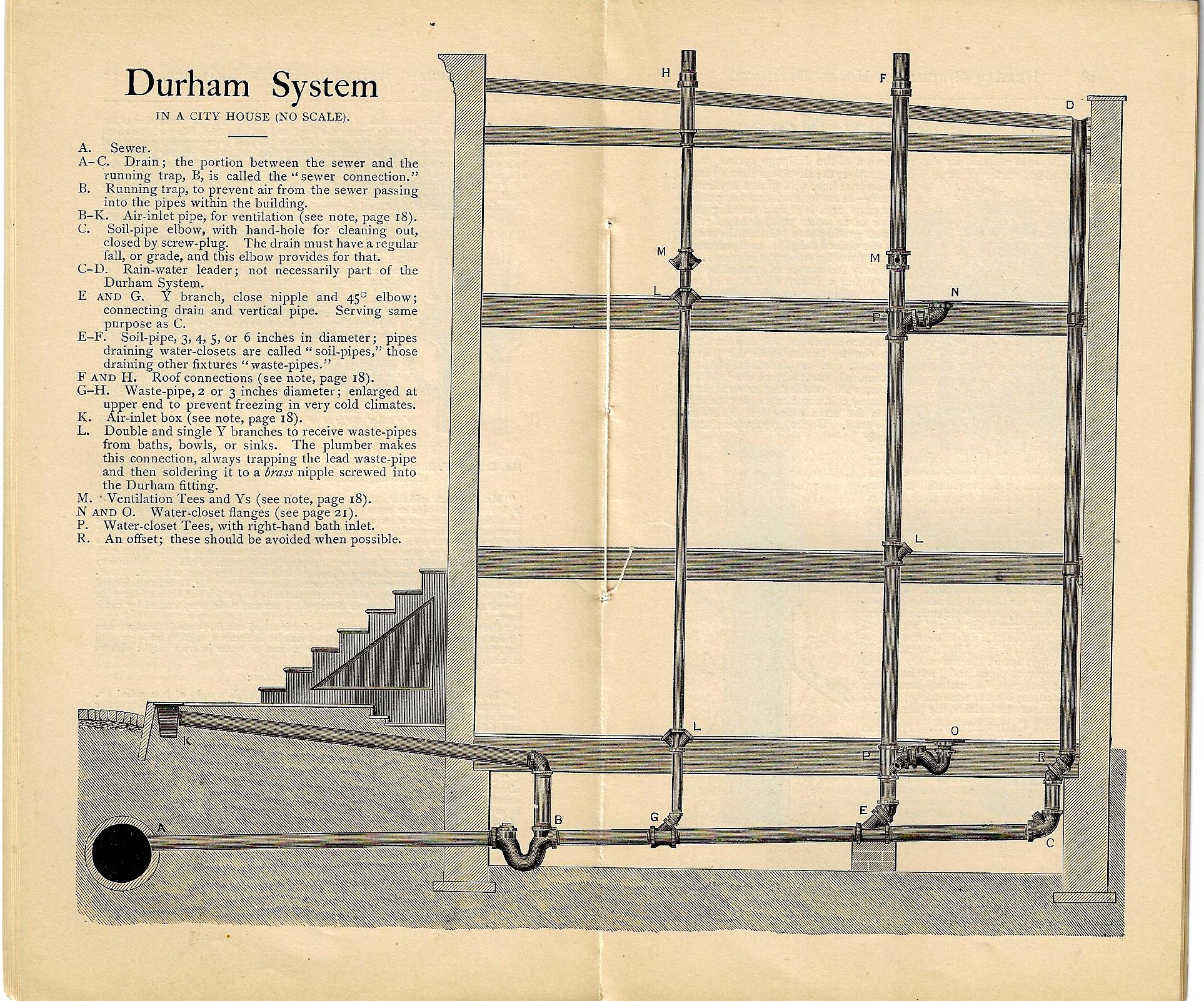
    Now 1892 is already decades past the Second Industrial Revolution (as was indoor plumbing) and of course cities continued to grow, and so did the needs for plumbing in delivering the byproducts of consumption and maintenance of the city. The Durham system–manufactured in NYC–was one of these responses, and the image below shows a cross section of a multi-story structure with a several toilets, basically a map showing the flow of the exuded lubricant of the great machinery of the city.  That prose was a little purpley, but it is sorta true. 

    The Durham Patent System of Screw-Joint Iron House Drainage addressed this issue, manufacturing the pipe and all of the other necessaries, ready for you to install:

    Durham drainage _1_


  • Outsider Real Politik from 1942 (“Straight Boundary Lines. Stop–Wars.”)

    JF Ptak Science Books   Post 2695   History of Lines series
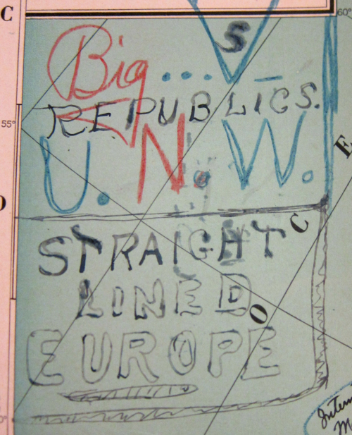
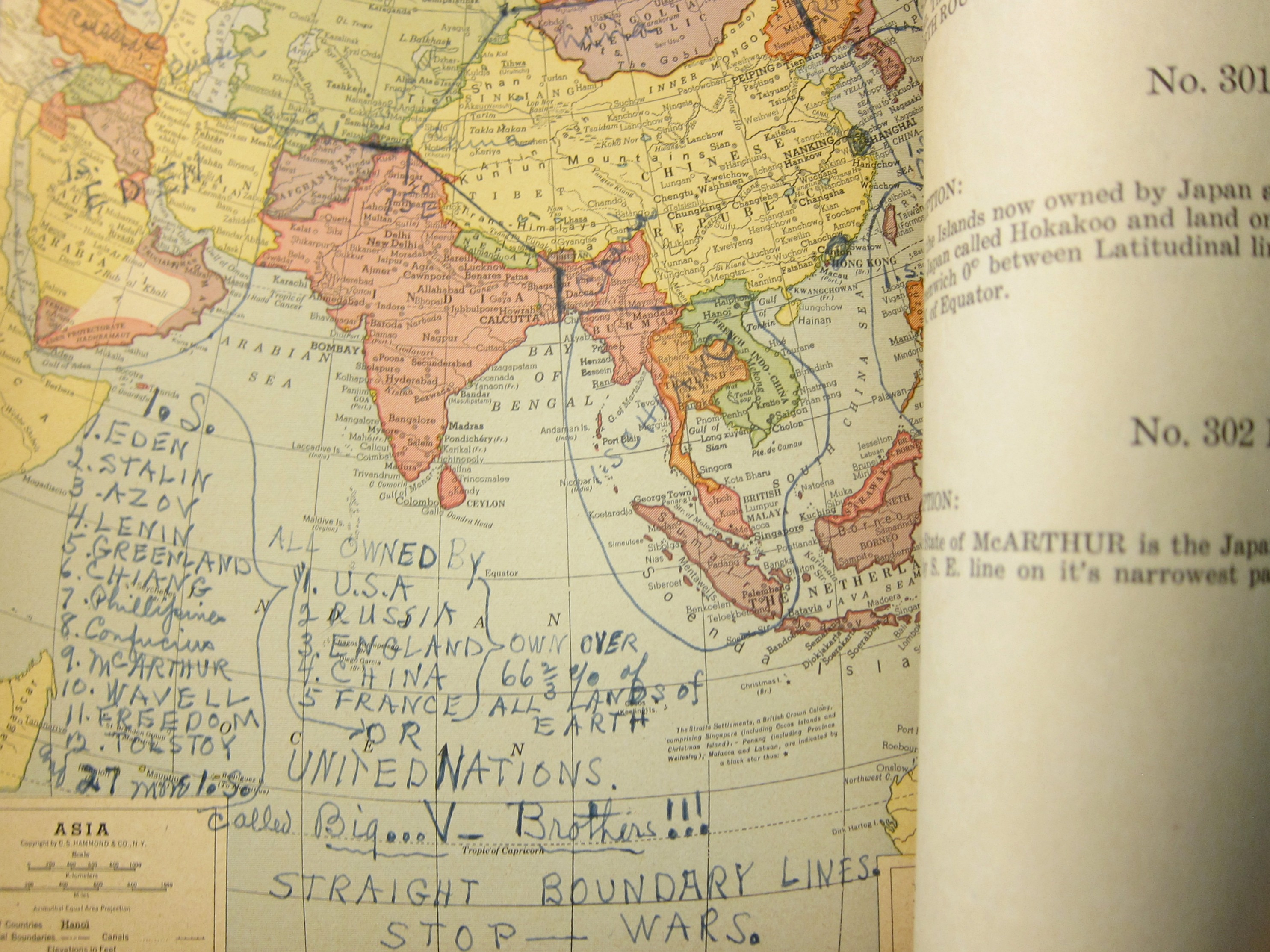
    Maps Outsider 1945 world map titleThis Outsider-y pamphlet on the reorganization of the world after the end of WWII was a very unexpected find.  Some of the thinking in the text could make your eyebrows touch your cheeks from their dubious logic and idea base, but it is the map to illustrate the distribution of political existence for most of the countries of our planet that is the most remarkable component of this exegesis. 

    First things first: I cannot find the author’s name, though it is doubtful that I would have posted it here, given the amusement park wonderfulness of this foreign policy.  The bumpy title of this far-reaching work , United Nations of the World Washington, D.C. U.S.A. January 1, 1942, Started the New World Era Called the Dawn of the Golden Age Which is the Beginning of the End of all World Destructive Forces, should give a bit of a hint to what might follow…at least this is the case for many of the 1000-odd Naive Surreal/Outsider Logic pamphlets in my “collection”.  The work (11×8.5″, 14 printed leaves, 8 maps) was printed on April 25, 1942 (so noted on the last page, along with the manuscript annotation, “Plato”), and made its way here via the Library of Congress. The pamphlet began its journey though at the White House–in the right corner of the pamphlet cover you can see the rubber stamped “Respectfully Referred to the Department of State” followed by [some name], “Secretary to the President”. As it turns out that name was Marvin H. McIntyre, who indeed was the secretary to the president. McIntyre has been with Roosevelt since the later’s VP campaign in 1920, and then joined FDR at the White House in 1933, when he remained as one of the three secretaries to FDR until he died in 1943. In any event, the author must’ve sent his idea of re-arranging the world directly to Roosevelt; McIntyre though it better for Roosevelt to not be distracted by this work and no doubt sent it off for the DOS people to deal with. The very faded rubber stamp at bottom seems to indicate that it was received at State in May 1942, which means it made a rocket exit from the WH. Then either something or nothing happened until it was sent to the Library of Congress in 1947.
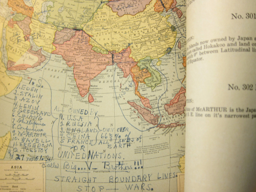
    Maps Outsider 1945 Lines stop wars
     

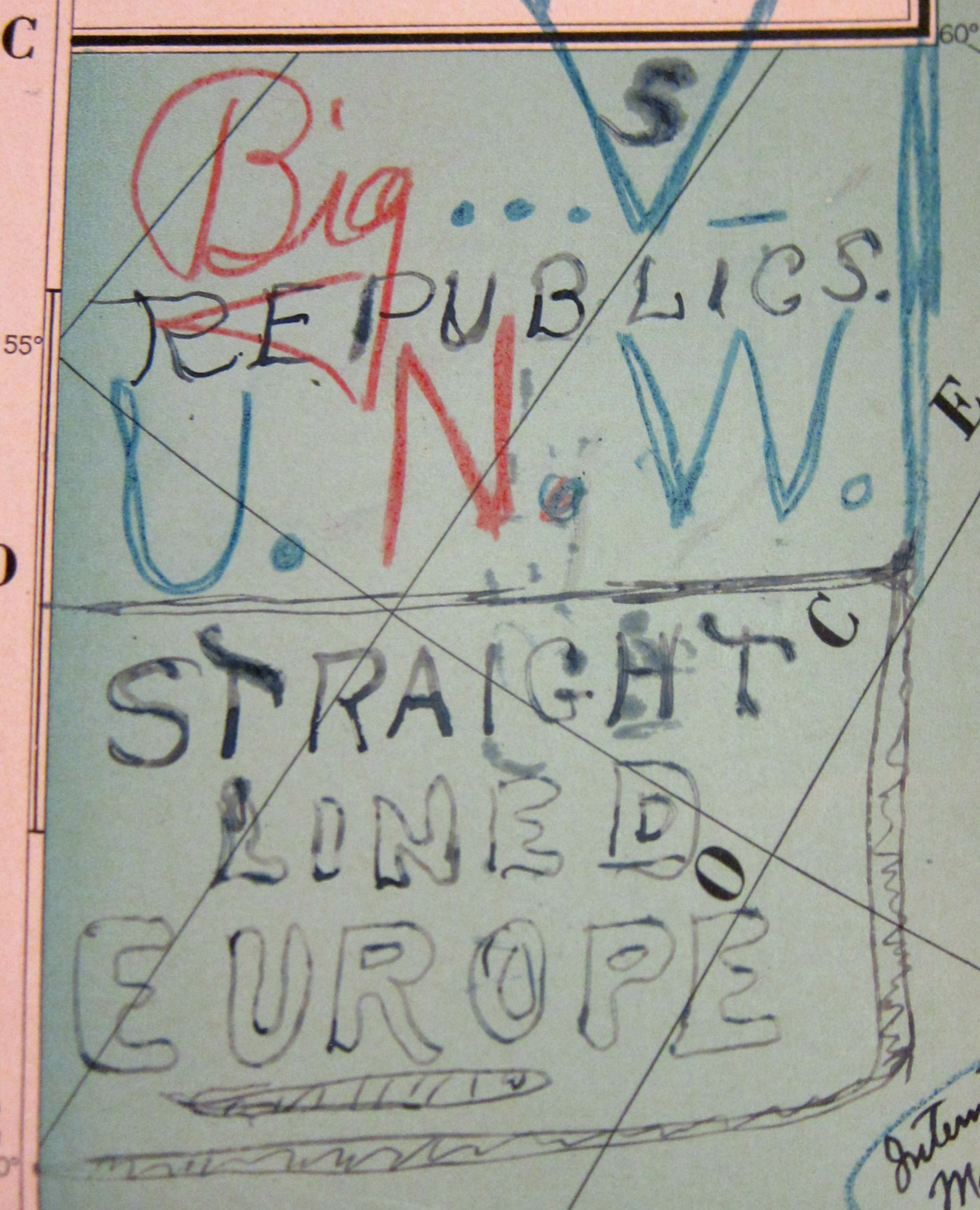
    The main deal here is that the United Nations of the World seems to be composed of five countries–the U.S., Great Britain, France, China, and France–with the headquarters in Washington D.C. (including a small part of Virginia “and some of Delaware”) because “a more appropriate place on Earth Planet cannot be found for UNITED NATIONS OF THE WORLD”.  How the distribution of national identities, the disappearance of most national governments, property, wealth, armies, navies, and so on, is accomplished, I do not know, as there isn’t a clue in the work.  I do know that the author complained of too many curved lines for boundaries and insisted on straight lines. That didn’t stop him from going curvey, though, as we can see in the development in North America, where for some reason San Francisco is now an “IS” or “International State” called “the Golden Era”.  

    Some of the other changes introducing the new International States include:

    • “Light” (Canada);
    • “Petain” (West Africa);
    • “Eden” (the Middle East);
    • “McArthur” [sic] (northern Japan);
    • “Confucius” (southern Japan); 
    • “Liberty” (the USSR)
    • “Liberty” (Belgium and Holland and other bits and pieces);
    • “Edison” (northern Germany);
    • “Franklin” (southern Germany);
    • “Lincoln (norther Italy);
    • “Plato” (southern Italy);
    • “Stalin” (Bulgaria);
    • “Lenin” (the Baltics);
    • “Wavell” (Papua New Guinea);
    • “Wellington” (New Zeland);
    • “Churchill” (central-ish Africa)
    • Turkey would become part of Russia (“in 1950 A.D.”).

    There are a number of others, all findable in the expandable images below.

    In the end, the U.S., “Russia”, “England”, China, and France (for reasons unknown) would “own over 66 2/3 of all lands of Earth”. 

     There is no indication how all of this would work, including 2/3 of the world being “owned” by the five countries. Of all the problematic bits in this work perhaps the problematiciest is the voting arrangement in the Supreme World Court, which would create an equal voting block between the U.S./U.K. and China/USSR, the deciding factor being (yes, you guessed it) France. 
     

    ·Posted by :

    ·in:


  • North American Native American Populations from a 1790-ish Source

    JF Ptak Science Books   Quick Post

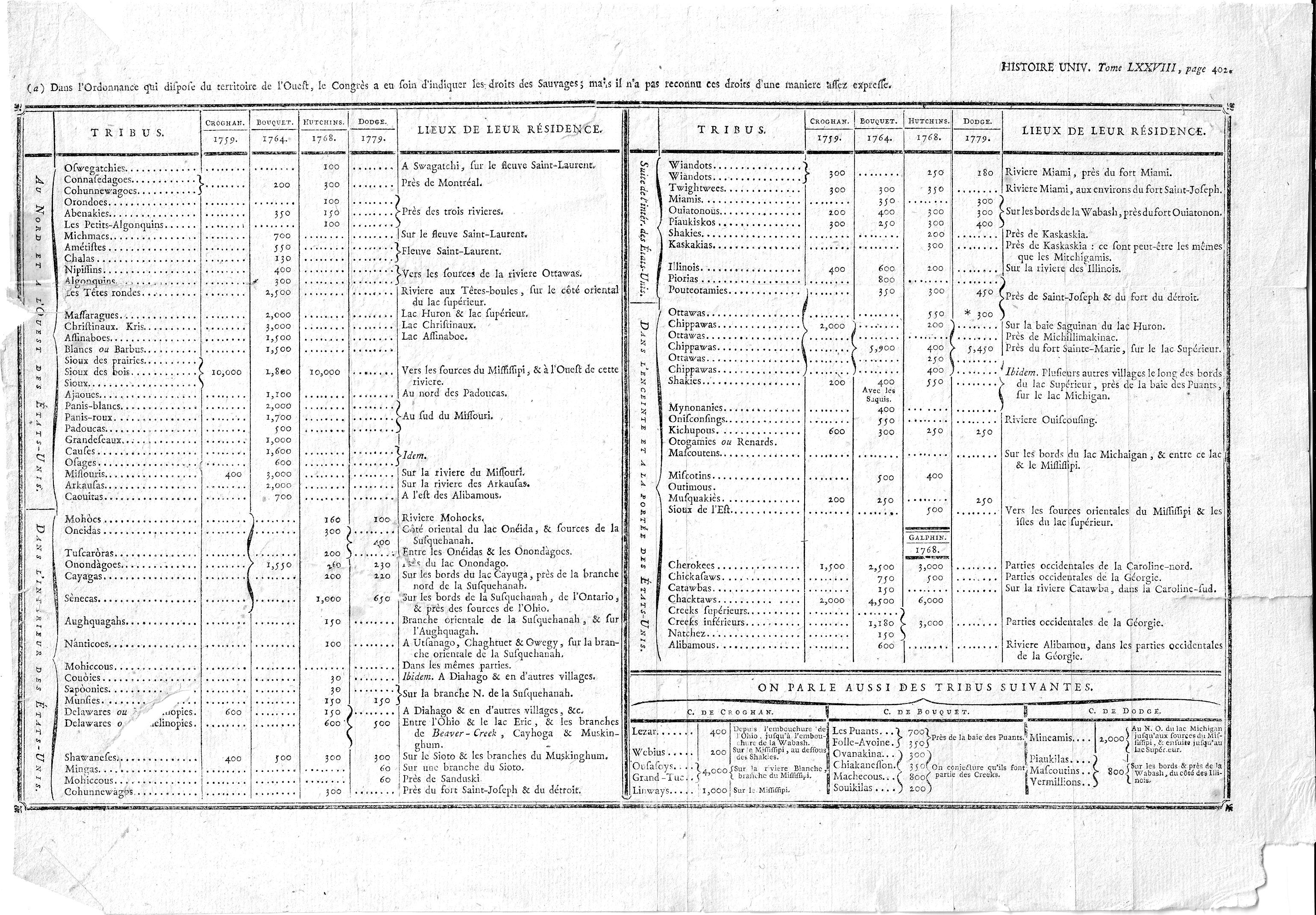
    I’ve decided to simply post this interesting chart without comment–it seems that in my experience I haven’t often seen such a long list of tribes with populations at such an early date. Here’s the thing, though–I’m not exactly sure of it origin. It is a folding plate from Histoire Universelle, though with this generic title I don’t know the author or year, though I guess it to be 1790’s (judging by the paper and other clues). As a matter of fact the only hit I get from the interweb on the title of the graphic is for a reproduction of the data over four pages in Jean Nicolas Démeunier’s L’Amérique indépendante, ou Les différentes constitutions des treize provinces…though he gives no attribution for his heavily-borrowed stats. The author of this set of stats though, did, with estimates of population numbers from four sources for 1759-1779. So:

    Indian tribe populations

    And some detail images:


  • The Barrels of Brooklyn, 1873

    JF Ptak Science Books   Quick Post 

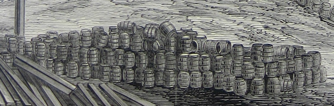
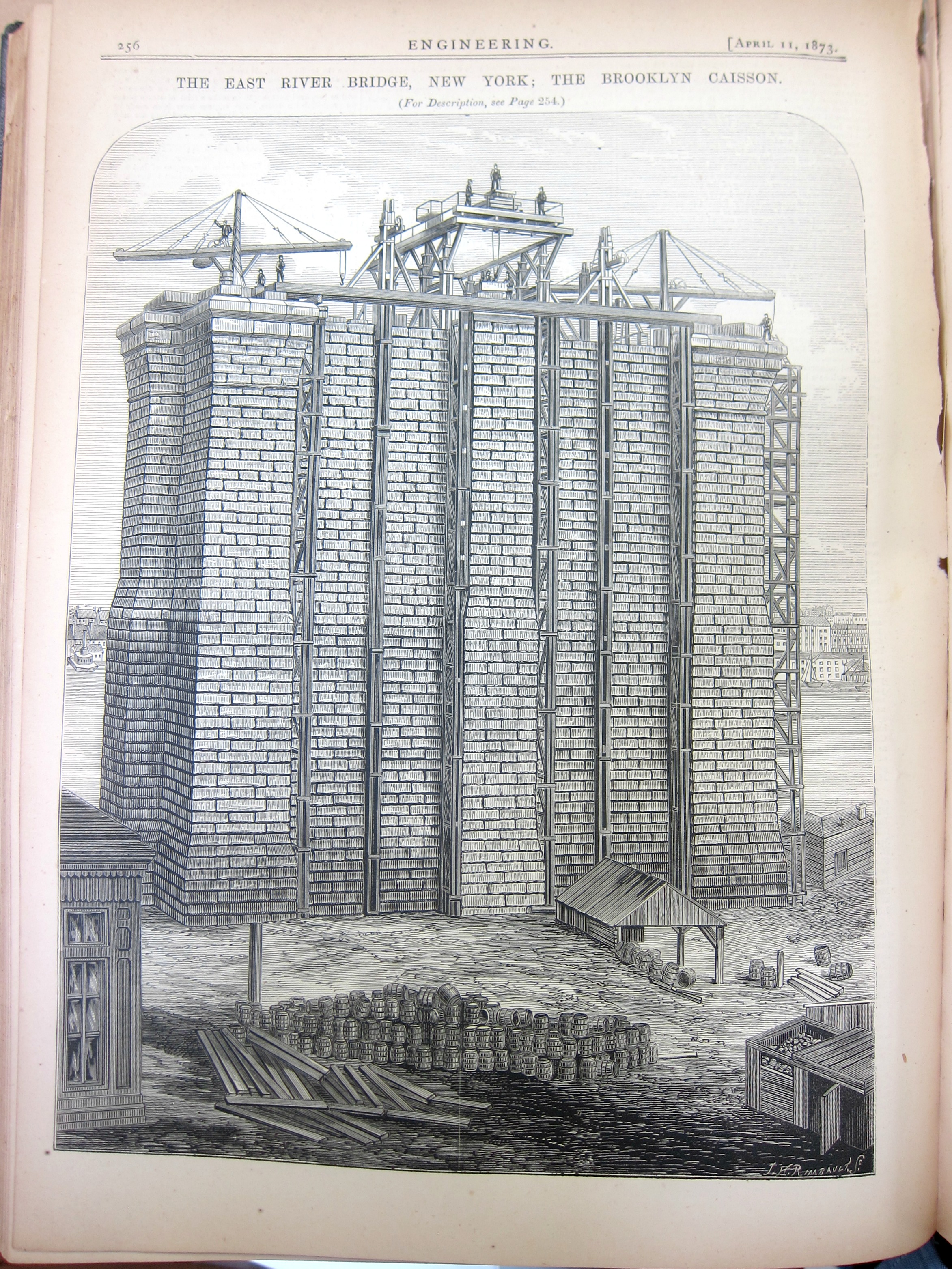
    This dramatic image of the foundations of the New York and Brooklyn Bridge (and then the East River Bridge, and then in 1915 the Brooklyn Bridge) appears in the journal Engineering for April 11, 1873. It is a massive structure, and like a tree there is as much going on for it underground as there is above; and in all of that, one of the most interesting elements is the pile of barrels in the foreground, a detail of which is below: 

    Engineering 1873 Brooklyn barrels

    Frankly I’m a little surprised at their state, disheveled and open and spilling here and there.  Why not keep them in order of some sort? 

    And the full image, featuring the granite that was moved by schooner down along the coast all the way from Vinalhaven Island, Maine: 


    Engineering 1873 Brooklyn Bridge