A Daily History of Holes, Dots, Lines, Science, History, Math, Physics, Art, the Unintentional Absurd, Architecture, Maps, Data Visualization, Blank and Missing Things, and so on. |1.6 million words, 7500 images, 4.9 million hits| Press & appearances in The Times, Le Figaro, Mensa, The Economist, The Guardian, Discovery News, Slate, Le Monde, Sci American Blogs, Le Pont, and many other places… 5000+ total posts since 2008.

Category: Maps, Cartography, History of Mapmaking

  • A View of Manhattan from the Top of the Brooklyn Bridge, 1877

    JF Ptak Science Books   Quick Post

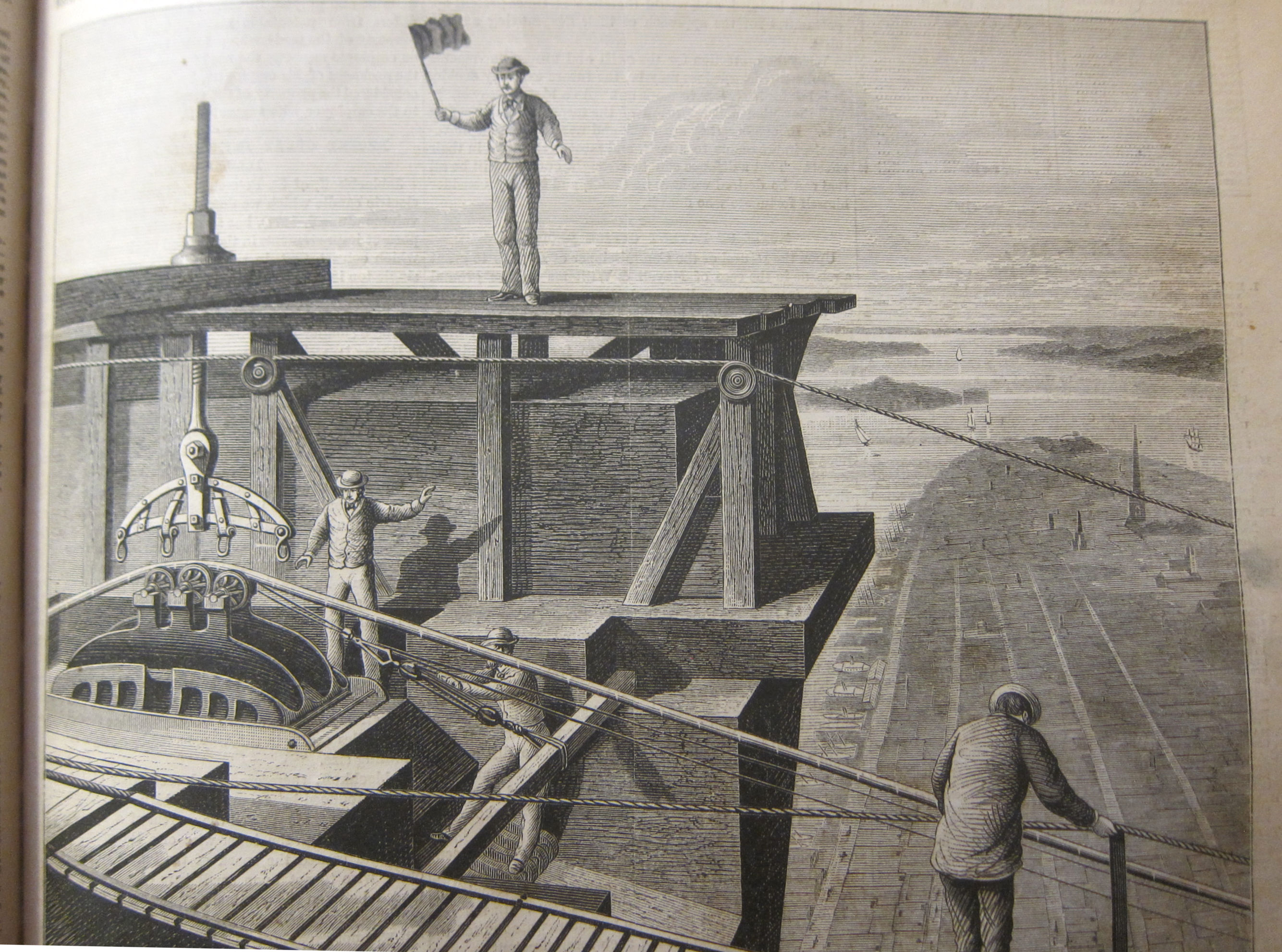
    Yes,  this is indeed a wonderful and celebratory view of Manhattan from the top of the East Tower of the under-construction East River (“Brooklyn”) Bridge. The thing about this is that the view seems to be too good, the tower too tall…unless there is something odd about the perspective and bird’s eye view of it. From this vantage point we’re looking south-east towards the battery and then Governor’s Island and then out to Jersey and Brooklyn with Staten Island in the distance.  Now the steeple we see downtown is Trinity Church, standing there at 284′; given that the tower is 278′ tall,  this perspective completely dwarfs the church for reasons I do not know. I’m not sure what’s going on–perhaps this is more a suggestive view than an actual you-are-there rendering.   The source:  Scientific American, October, 1877.                         Sci Am 1877 Brooklyn Bridge


  • A Map of Prostitution AND “Negro” as a Nationality (1913)

    JF Ptak Science Books  Post 2813

    There were two big surprises in this 1913 work1 on prostitution in Portland, Oregon–I mean, aside from the normal “surprises” and “unexpecteds”one expects from an early 20th c study on the sex trade. (If someone wanted to do a version of The Deuce as Portlandia Nights 1913 this report would be atomic material.) The book runs 200 pages and for the time is filled with unusual social history, snapshot observations, interviews, police involvement, data of all shapes and sizes, and that sort. The book is fairly comprehensive–all things considered–and the efforts are distributed to the following sections: “A Report on the Social Evil, as affecting places of public resort and accommodation; hotels, apartment houses, rooming and lodging houses”, pp 4-81; “On the Legal and Police Aspects of the Social Evil”, pp 81-122; “A Report on the Juvenile Aspect”, pp 123-164; “Report on the Economic Aspect”, pp 165-202; “Report on a Segregated District”, pp 203-216.) Overall it is a survey of the grand scheme of prostitution (the “Social Menace”) in Portland as it existed in one section of the city (Irving Street-Hall Street-23rd St-Harbor line). It investigated 547 buildings/rooming houses and found 98 to be “moral”, 431 to be “immoral”, and a balance of 98 falling into a gray-ish “doubtful” category. 

    • This post is based on a copy of this report that I have here–there is something online text at Hathi that has a slightly different title but looks to be the same that you can enjoy here: https://catalog.hathitrust.org/Record/100641247

    The report surfaces some fascinating info: for example, there is a section on interviews with proprietors of the erstwhile hardly-vanilla hotels, which includes a number of very colorful quotes, including one “madame” from a bawdy house on Sixth Street, who claimed “Portland is the best town on the coast for a sporting woman to make money in.” Other madams agree! There are interviews with “sources of vice” (“grills, chauffeurs, pool rooms, messenger boys newsboys…”), police, civil service, hotel folk, that sort..  A good standard example of a description of one of the bawdy houses reads: “Hotel [unnamed and with no street address identified] Taylor Street. Shabby place of 46 rooms. Run by man and woman, who occupy front rooms, one of which the woman uses as a parlor, the other as a bed room for immoral business. Three prostitutes work for management, paying one-half of their earnings from bed money. Liquor sold.”

    The “study of the docket”  is a listing of occupations of prostitutes, arrests, charges, fines, and wages paid the prostitute; there is a section on “testimony” in which the sex worker tells her story, and another section on the general living conditions in the bawdy houses. The last section in the publication deals with “segregation”, though the type of segregation here has nothing to do with race, and simply means that there would be a set-aside space for sex businesses in Portland.

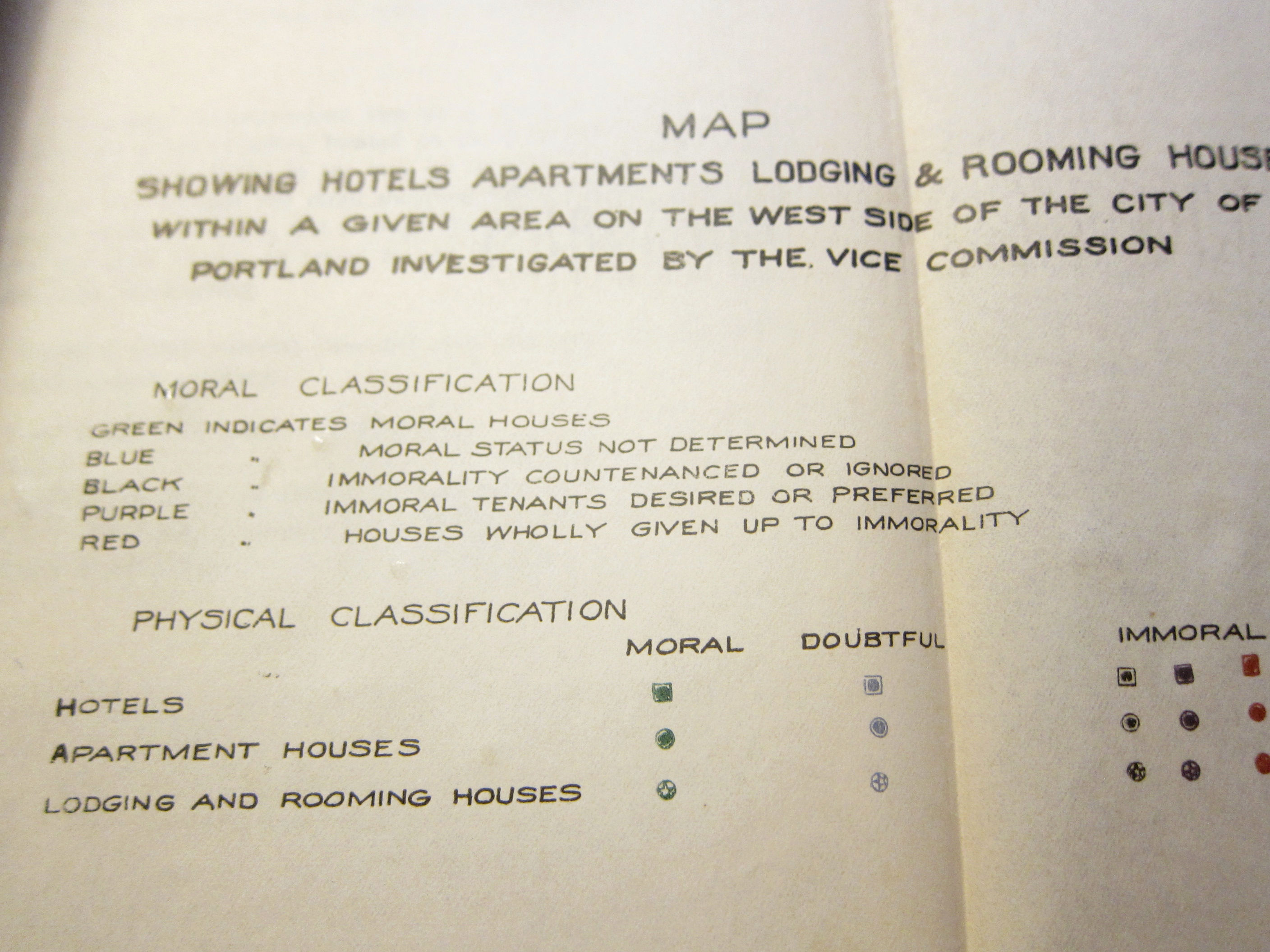
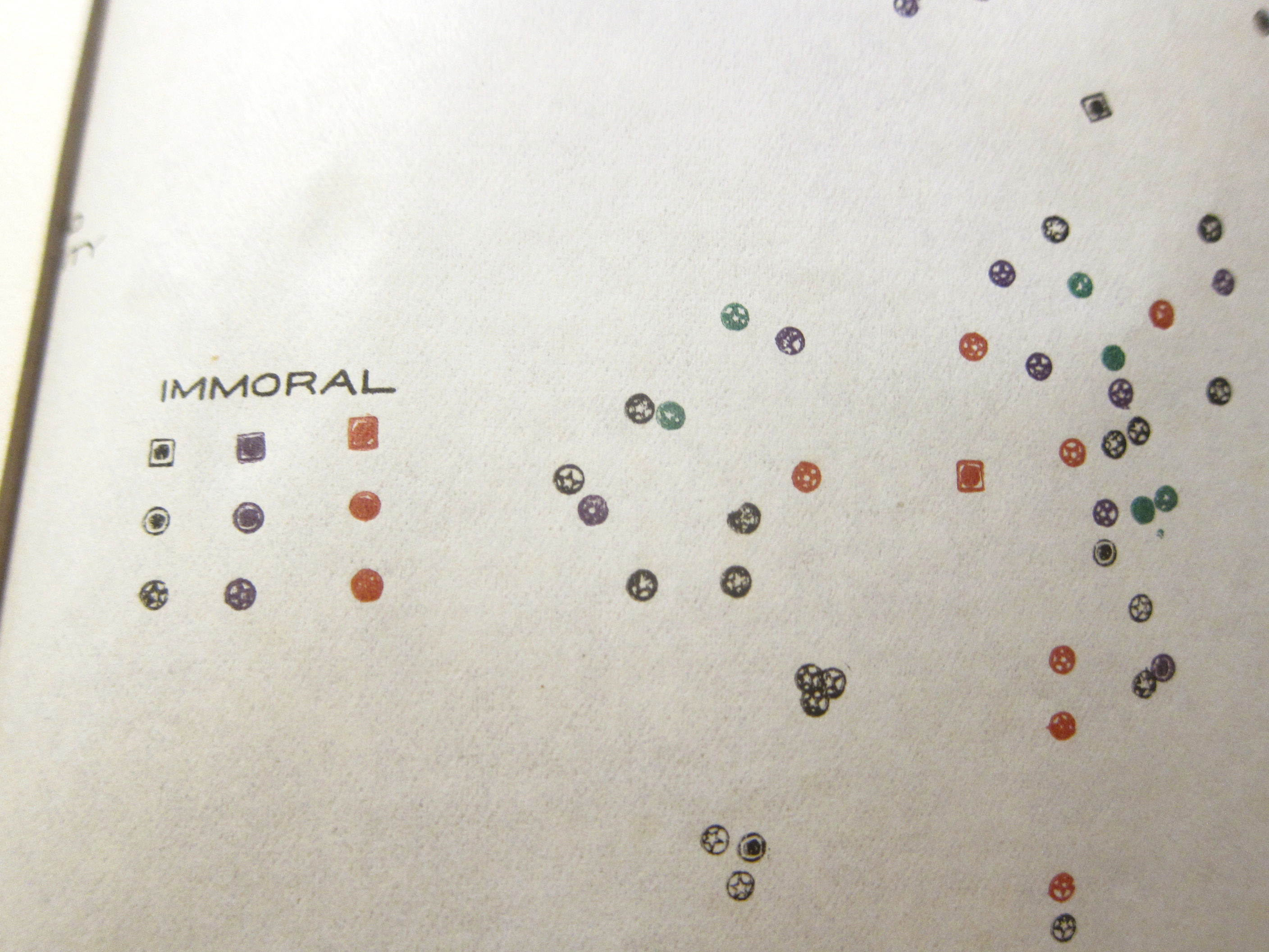
    So, the first surprise: there is also a very daring and fascinating map in the first section of the report which identifies hundreds of the Social Evils establishments. They are classified top-to-bottom in the following way: “Moral houses”, followed by “Moral status not determined” and then steeping into “immortality countenanced or ignored”, to “immoral tenants desired or preferred”, and then finally to “house wholly given up to immorality”. The odd thing about the map is that it seems to be overlay, meaning that the details of the actual geographical part of the map are left out and there is no underlying map on which this skeleton map is laid (as published). The map isn’t quite a “map” as much as it shows approximate vicinities and coagulations of these establishments in relation to one another and confined to that one particular part of Portland. I guess that leaving out the exact addresses was a preventative measure to squash the possible plans of some enterprising people to use a detailed map as a Guidebook to Portland Houses of Ill Repute.  

    Portland Vice Map
    Portland Vice Map

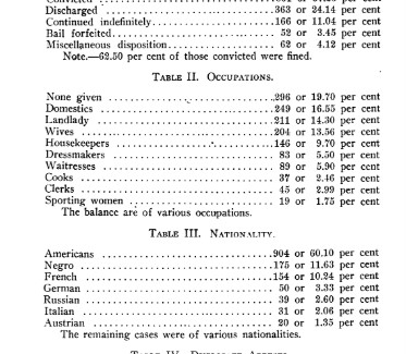
    The second major unexpected surprise: on page 96 there is a listing of nationalities of prostitutes arrested—in the accompanying table the leading nationality is “American” followed by “Negro” and then “German”…which seems to me that U.S. Citizenship is being denied to African Americans on the basis of race, and that, evidently, “Negroes” are not American citizens. And according to the law in the state of Oregon in 1913, “Negroes” were not even allowed to migrate to the state, stated as such right in the Oregon constitution—a law that was not addressed and eliminated until 1924. I suspect that African Americans were illegally in the state and thus, somehow, had their rights of citizenship in the USA stripped away. Or perhaps this was the work of a racist editor, or author, or someone;; one person, one small group, that instigated this classification. Or maybe it was someone ignorant who just go the whole thing wrong and which was subsequently missed by the editor. I don’t know. All I can say about this is that this is the first time I’ve seen African Americans introduced in a statistic post-1865 as citizens of the U.S. who were deemed to be not so. 

    Negro Nationality

    Notes:

    1. Talbot, Henry Russell. Report of the Portland Vice Commission to the Mayor and City Council of the City of Portland, Oregon.. Portland, 1913. 9”x 6”, 216pp. Original stiff wrappers. Provenance: Library of Congress via the Washington DC Public Library.   


  • A Map of Japanese Intentions for Conquest Extending to Hawaii–1933

    JF Ptak Science Books  Post 2812

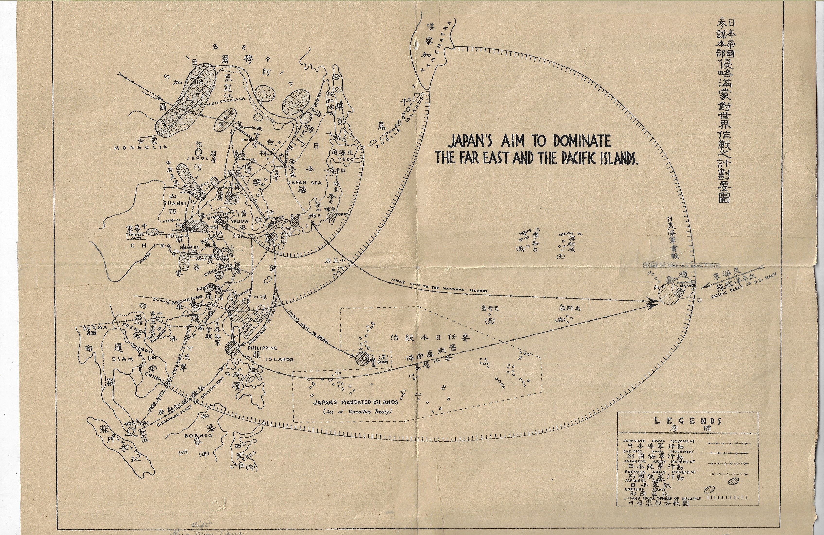
    I do not unfortunately have much information on this very interesting (and to me unexpected) map, nor do I know very much about the history of Japanese militarism and planning 1925-1935–I do though want to at least post/share it for interested parties. As you can see, the expected sphere of influence to be maintained by the Japanese in the near future extended to Pearl Harbor, Manchuria, and as far south as the northern Celebes.  What is remarkable is that this map was published no later than 1933. If you read the text of the pamphlet (below) you will note that was seen that Japan planned on world domination ten years hence (ca. 1943). The map:

    Maps Japan conquest map

    A Plan of Japan’s Proposed Military and Naval Conquest as Revealed in the Strategic Map appears no later than 1933. The single-sheet folded pamphlet contains two pages of text along with the middle two sheets of the map, “Japan’s Aim to Dominate the Far East and Pacific Islands”. The document was part of a very large collection I bought of the Library of Congress, and according to the pencil notes on the pamphlet it was sent to the L.C. by the “Kuo Min Tang” on May 13, 1933.  (It was curious to see the KMT referred to as though it was someone’s name, rather than a political party begun in the People’s Republic of China in 1894.)

    This is a piece of anti-Japanese propaganda coming from the KMT, and it is published by the Chinese National Salvation Publicity Bureau (844 Stockton Street, which looks today like it is the Sun Yat-Sen Memorial Hall) in San Francisco,  After all, the Japanese had been savaging around in China on and off since the First Sino-Japanese War at the end of the century, and then again heating things up in the early ‘thirties with the Japanese-instigated the Shanghai War and the invasion of Manchuria–the Chinese no doubt were seeking allies wherever they could them.  

    There are a lot of lines of conquest on this map, encompassing nearly all of South East Asia.  The largest sphere of “influence” extends all the way to the Hawaiian Islands, where the Japanese would take the islands by a “naval battle” with the U.S.  

    I’ve checked WorldCat for other copies and found only one mention–same thing for the internet.  


  • History of Lines Department: Weather Lines (1851)

    JF Ptak Science Books   Post 2794

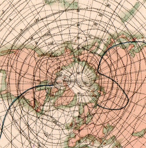
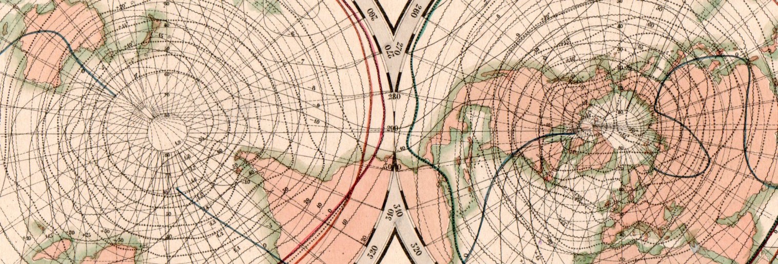
    This beautiful network of lines tells the early story of weather in cartographic form. They appear on Karte der Isothermen, Isoklinen, Isogonen und Isodynamen mit der Magnetischen Meridianen, and was published in the atlas to accompany the best-selling encyclopedic presentation of the natural history knowledge of the world to that time, Baron Alexander von Humboldt’s Kosmos, which was published over a period of several from 1845-1862. The map demonstrates and visualizes climatic information showing isothermes, isoclines, isogones and isodynamics, with the magnetic meridian.

    Map visualization isotherm653

    [This is a detail of the Northern Hemisphere section of the double-hemisphere map, which is reproduced below.]

    Map visualization isotherm654

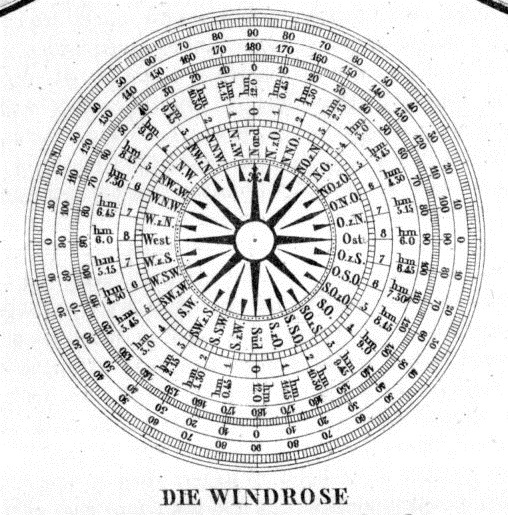
    At bottom there is also a beautiful 32-point wind rose:

    Map visualization isotherm651


  • A Fine Map from Alexander von Humboldt (1851)

    JF Ptak Science Books   Post 2793

    Before the Neil deGrasse Tyson version and update of Carl Sagan’s landmark television series, Cosmos, there was Alexander von Humboldt, and his enormously influential book of the same title, printed in 1845-1862.  Well, von Humboldt’s (1769-1859) book was actually Kosmos when published in German, which is where it started its life (and which von Humboldt suffered mightily for in it English translation).  Von Humboldt was enormously studied and educated and of a high scientific mind over many subjects, one of those 19th century figures who seemed as though they could know everything, a polymath of high order (along the lines of Goethe and von Helmholtz and Thomas Young and others).  He was a meteorologist and biogeographer before those sciences existed; a naturalist, geographer, archaeologist, and explorer, a natural philosopher of magnitudes.

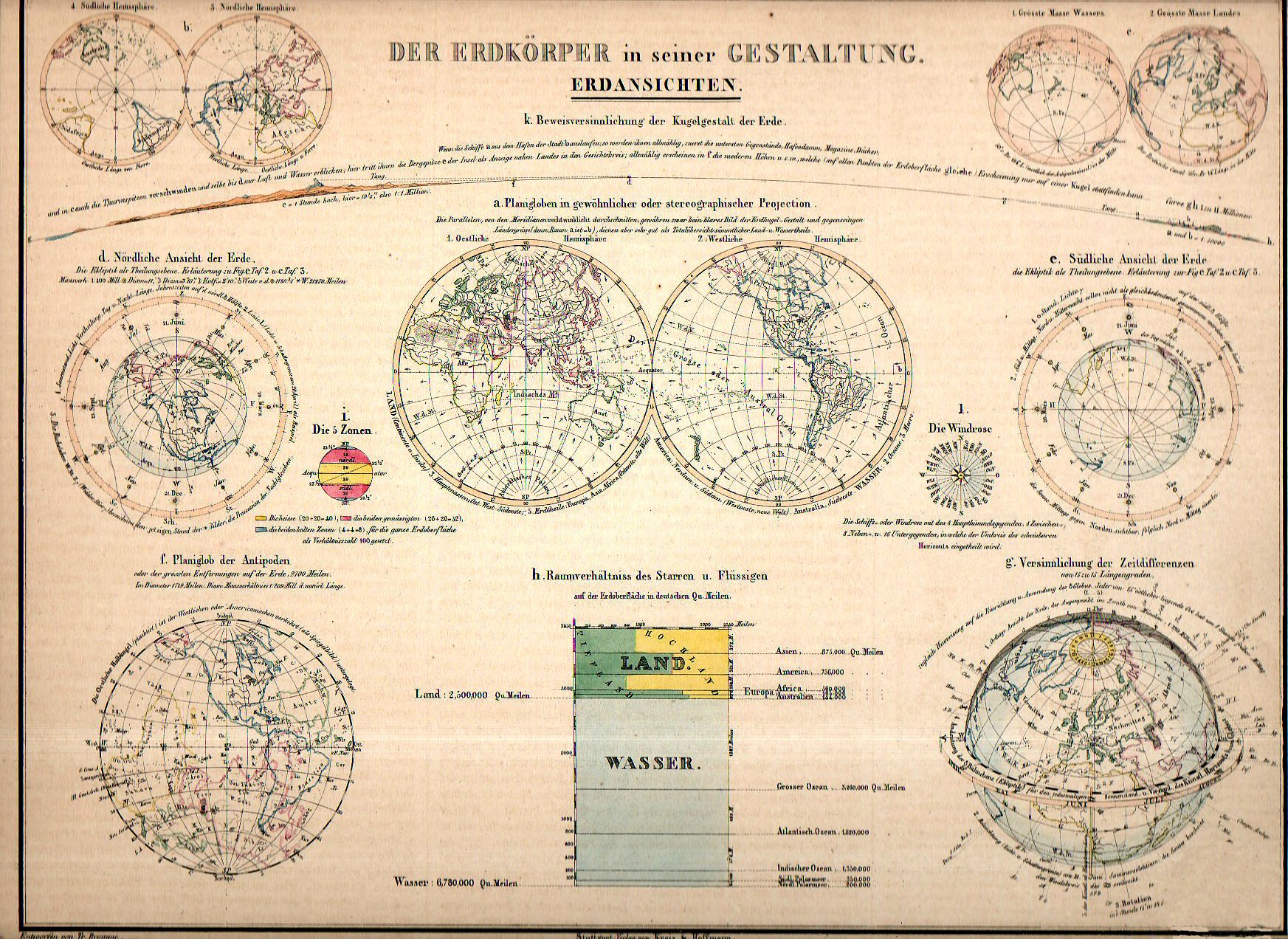
    Maps dataviz land wasser156

    • “Der Erdkorper in seiner Gestaltung. Erdansichten. Entworfen von Tr. Bromme. Ausgefuhrt v. E. Winckelmann”, published in Stuttgart, by Verlag von Krais & Hoffman.  This map appeared in  the atlas of Alexander von Humboldt’s Kosmos, 1851.  8.5×11.5″ image on 11×13″ sheet, with original hand coloring.

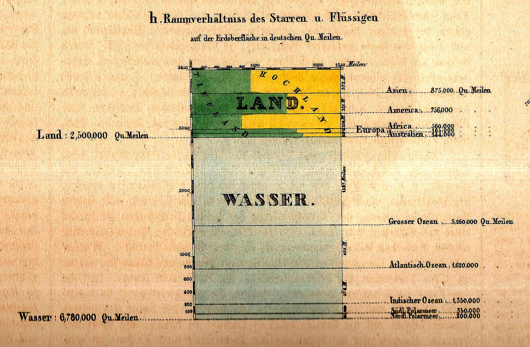
    And this fabulous small detail from the overall map:

    Maps dataviz land wasser detail

    Kosmos reflected his lifelong interest in order, and what he did was astonishing–he attempted to unifying the complexities of nature in one book (of five volumes), binding the various branches of science together in a cohesive whole, attempting to show how the laws of the universe acted here on Earth.  It was a very influential work, very progressive, a masterwork of scientific method.  

    Sagan (and Tyson, soon) tried to explain what the universe was all about; 160+ years ago, so did von Humboldt, and for his time he came damned close to doing so, or as close as anyone could possibly come. 

    The fine little inset above (1×1.5 inches in real life) is an excellent display of water/land mass of the Earth, and is but one of eleven such images on this beautiful image.


  • A Suggestion for Another Genre of Boundary: the Nothing Frontier, 1900.

    JF Ptak Science Books   Post 2792  Part of the History of Nothing series

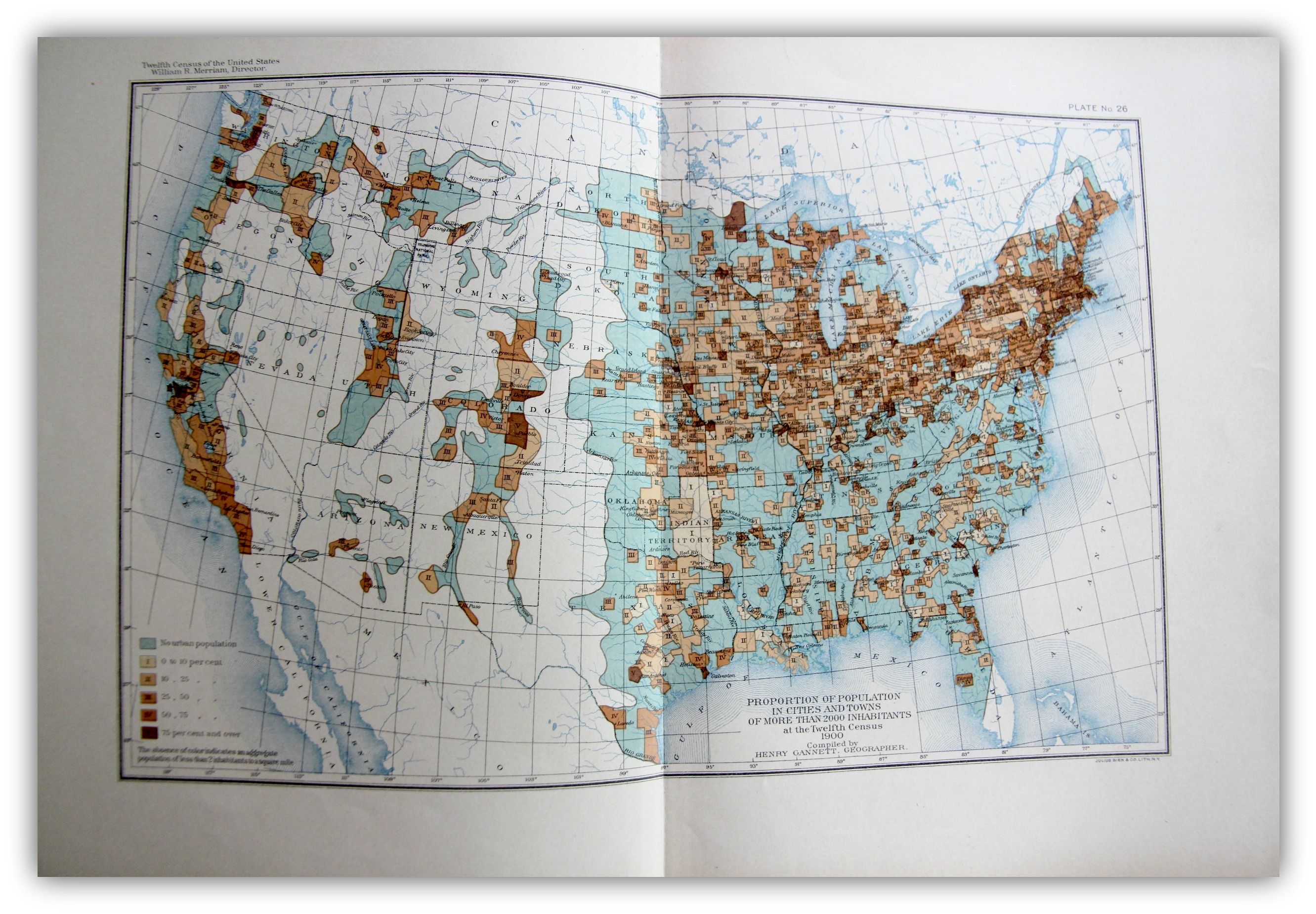
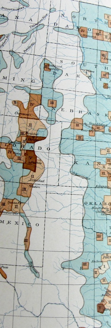
    The “frontier” in the history of the U.S. West is a pretty big deal, and old, the academic concept of  the frontier pressing its way back 13 decades, when for the most part once it was introduced it was pronounced to be “closed” by the man who reinterpreted it, Frederick Jackson Turner1.   On my shelves alone there are books on the mining frontier, the mineral frontier, the transportation frontier, the Indian frontier, the military frontier,the farming frontier, and so on, divisions allotted by wealth, nationality, numerous geographical attributes, and the like. One thing I think that I have not seen was the Nothing Frontier, where there are divisions divided by, well, sort of “nothing”. This is mostly a prosaic statement, slightly poetical, dependent on visual clues. And of course there isn’t “nothing” there because there is always “something”–there just isn’t very much of it.  And when things get colored-coded on map depending upon percentage distributions, and that object of measurement is left to a null color or no color at all, then it appears that the divisions one left to nothing.

    Maps--Census 1900 Urban

    [The image above is very expandable.]

    This can be seen if you squint somewhat you can see an example of it in plate 26, “Proportion of Population in Cities and Towns of More than 2000 Inhabitants…” Statistical Atlas, prepared under the Supervision of Henry Gannett (Geographer of the the Twelfth Census), printed in Washington by the U.S. Census Bureau, 1903. This map–which is part of an historic series of atlases published with U.S. census data–shows the distribution of urban population in five shades of brown (as seen in the legend) plus a blueish color for “no urban population” as well as no color (“The allowance of color indicates an aggregate population of less than 2 inhabitants to a square mile”).

    Maps Census 1900 Urban detail

    It is that absence of color that makes it a frontier-ish sort of frontier, a part of the Made Up Frontier, this one being very straightforward north/south, Big Bend to Montana, pretty much the Lonesome Dove trail from the rough Big Bend Texas to nearly Canada.  

    I know it is just a thing I made up just now looking at the map, but given some effort, maybe the idea actually has some legs.  

    Notes

    1. Turner, Frederick Jackson. The Frontier in American History, Harvard University, 1920, full text via Project Gutenberg,  http://www.gutenberg.org/files/22994/22994-h/22994-h.htm


  • Geronimo Finally Defeated: of Miles, miles, and the Sun (1886)

    JF Ptak Science Books  (Expanding on an earlier post from 2011.)

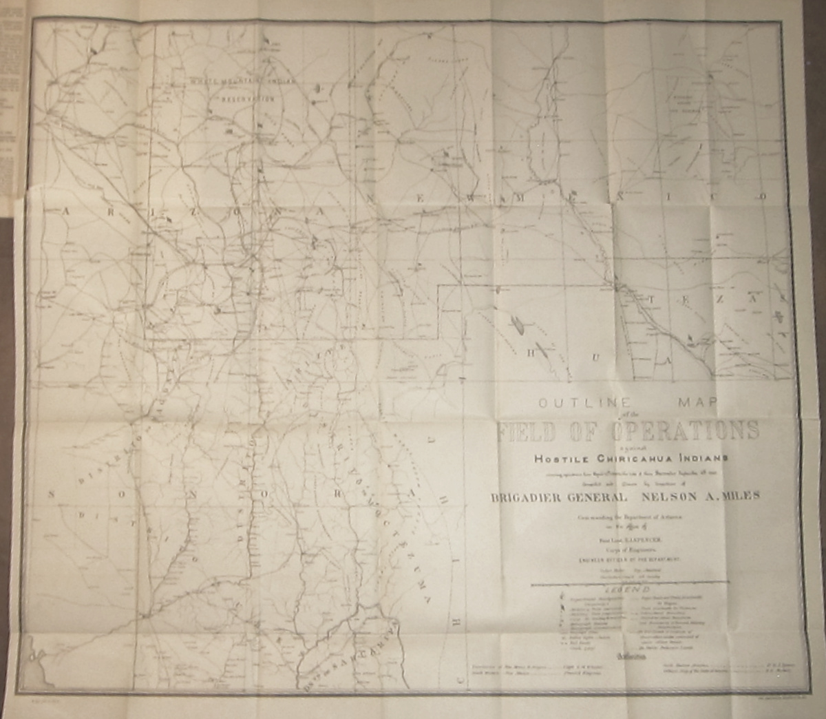
    The Chiricahuan Apache leader and chief, Geronimo (1829-1909), famously led a progressively diminishing band  through the  Apache Wars of the 1850’s-1880’s.  For thirty  years of so he quirted the U.S. Cavalry, darting here and there in great exploits and famous escapes, evading the armies of the United States and Mexico.  In the end, by 1886, there were just dozens who were following him, including women and children, and the elderly, ragged, tired, hungry, and pretty much, finally, beaten. A graphic display of this end is found in this terrific map:

    Geronimo _1_ full
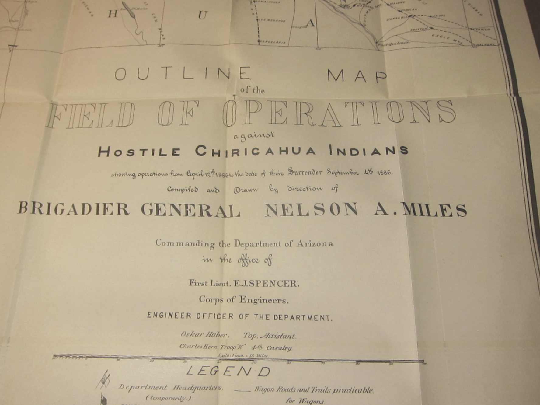
    Outline Map of the Field of Operations against Hostile Chiricahuan Indians showing operations from April 12th, 1886 to the date of their Surrender 4th, 1886, which is a large, 29×25-inch folding black and white map lithographed by the American Graphic Company.1  [It covers all of Arizona and New Mexico south of 34 degrees N, from Phoenix on the west to not quite Roswell on the east, northern Sonora to well below Hermosillo, and extreme west Texas, and locates at least 40 army forts, camps and posts, as well as innumerable railroad whistle stops, ranches, and water holes…and of course locations of heliographic stations.]

    .

    Geronimo _2_

    I think what finally did Geronimo in were the miles of pursuit and the sun. 

    The sun got to him via the heliographic communication network established by Major W.J, Volkman under the direction of General Nelson Miles (the other “miles” of this equation of defeat), which allowed the pursuing American army to communicate instantaneously over great distances, over hundreds of miles, without the need for runners or men or horseback or cutable telegraph wires or time  The heliograph is an ancient instrument, used for more than two thousand years–in this case, they were very highly polished mirrors that reflected brilliant signals between stations, getting their light source from the sun. It allowed the army an enormous advantage, and one that finally caught up to Geronimo.

    The “miles” were just those, the thousands of miles Geronimo was tracked and retracked over that very difficult terrain in the southeastern part of Arizona and into northern Mexico, sharp mountains, endless badlands, caves, heat, height, cold….very difficult. (I’ve been there on treks.. .its tough land.)

    The capitalized “Miles” was the surname of General Nelson A. Miles who sent out  with Lt. Col. George F. Crook to track down and capture Geronimo–and they almost did, again, in late March, 1886, when Geronimo presumably surrendered, but then fled to Mexico. After another five months and 1,600 miles, Miles came upon Geronimo om in Sonoran mountain camp, and induced him for the final time in September, 1886, at Skeleton Canyon, Arizona.

    The details of the capture and surrender are told in many places by many others–I just wanted to surface the role of the sun in the capture of Geronimo.

    The old man was shipped east,  never to see Arizona again. He died after being thrown from his horse and contracting pneumonia as a result of being unable to help himself to safety through a long cold night, died in a bed as a prisoner in Ft. Sill, Oklahoma.


  • When a Map Should Probably Not Have Been Made

    JF Ptak Science Books  Quick Post

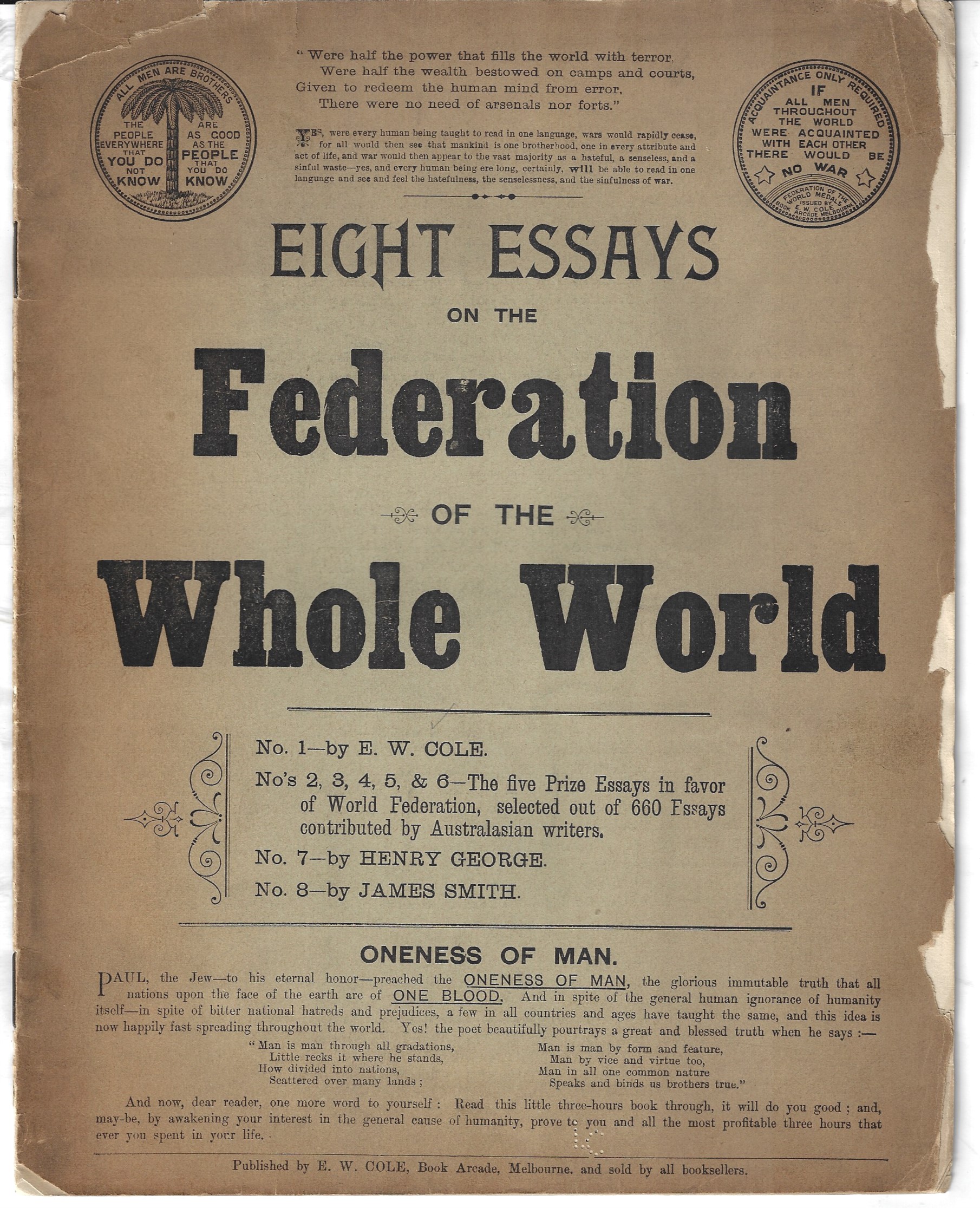
    This pamphlet was a little confusing to me–at first I thought it would fit into a category of Outsider creations, a small collection of pamphlets filled with some towering and submerged ideas on curing the Depression, keeping the U.S. out of war, flagpole painting, zipper repair, exrta-Earths populating the (regular) Earth, eyestalk plant people of Mars, flooding the Sahara, damming the Hudson River, nuclear powered _____, mega weapons, mega planes, hair massage for higher IQ, and so on. The design of the pamphlet certainly had the feel and look of a great attempt at conveying some secret truth, it turns out that it is pretty straightforward, an 1890’s/1900’s  appeal to folk on acting courteously and amicably towards others to achieve a one-government-something. 

    The message was very simple: do good, be kind, help people, live your religion.  It was the work of a very successful bookseller and publisher in Melbourne, Edward William Cole1. He sounds like he was an interesting guy, autodidact and entrepreneurial, born in the U.K. and migrating to Cape Colony and on to Australia, spending time in the gold diggings, exploring the Murray, and settling into Melbourne where he opened up a bookshop in 1864 which morphed into a large arcade with many rented kiosks.

    Cole wrote a number of short pamphlets, published them, and either sold or gave them away–the pamphlet presented here was probably a gift to his customers. It published eight essays of 660 collected for the prize of publication, extolling brotherhood and the commonality of the human condition, appealing for kindness and the common good, and reading above nearly all else. 

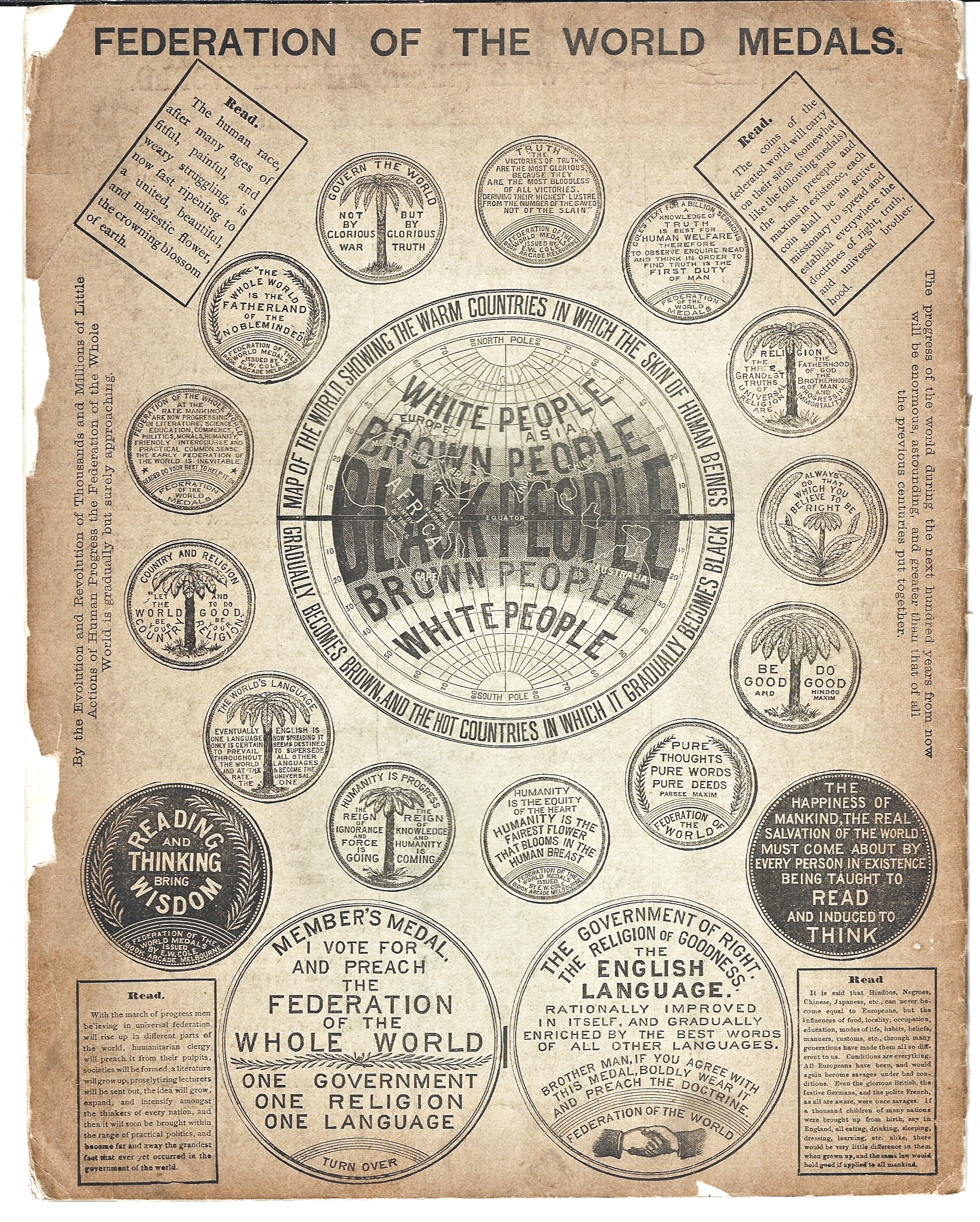
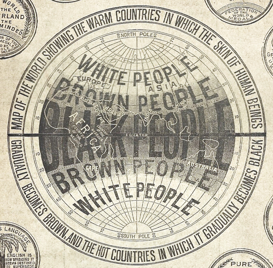
    The imagery on the rear cover is striking, most of the artwork being the fronts and backs of medals/medallions that Cole had made. The image in the middle of it all is, well, very surprising, and potentially disturbing, though it seems unconnected to any of the essays or sentiments of the pamphlet, and seems largely to be a non sequitur.  In any event there seems to be no connective text, nothing on race dominance or eugenicism, the only thing that comes close to that is a repeated belief that English should be the dominant world language for its “perfection”.  As dire as it seems the map seems to be open to speculation, though on the face of it doesn’t look like much good could come . Is it something as nasty as showing what the map maker thinks are the natural divisions of the world according to race, or could it possibly be suggesting that skin color is based on location on the globe and has nothing to do with any sponsorship of superiority or inferiority based on color? Given the rest of what seems to be in this pamphlet, it seems likely that the later is the case. The guy would’ve been better served if he left the map out.

    I’m reproducing the artwork here because there seems to be little mention2 of this work outside of stiff and undated bibliographies of books-received. 

    Black People front

    Black People front
    Black People front

    Notes:

    1.  Cole’s entry in the Dictionary of Australian Biography: http://adb.anu.edu.au/biography/cole-edward-william-3243

    2.  According to WorldCat there’s another version of this work, fleshed out to 207pp,, printed around the same time (the librarian guesses ‘189_’) and located in just one library (Victoria). There’s only one copy located of the copy mentioned here, located at the Murdoch library, 11,564 miles from where I sit in western North Carolina. 


  • The First Weather Map Printed in the U.S. (1838)

    JF Ptak Science Books   Post 2794

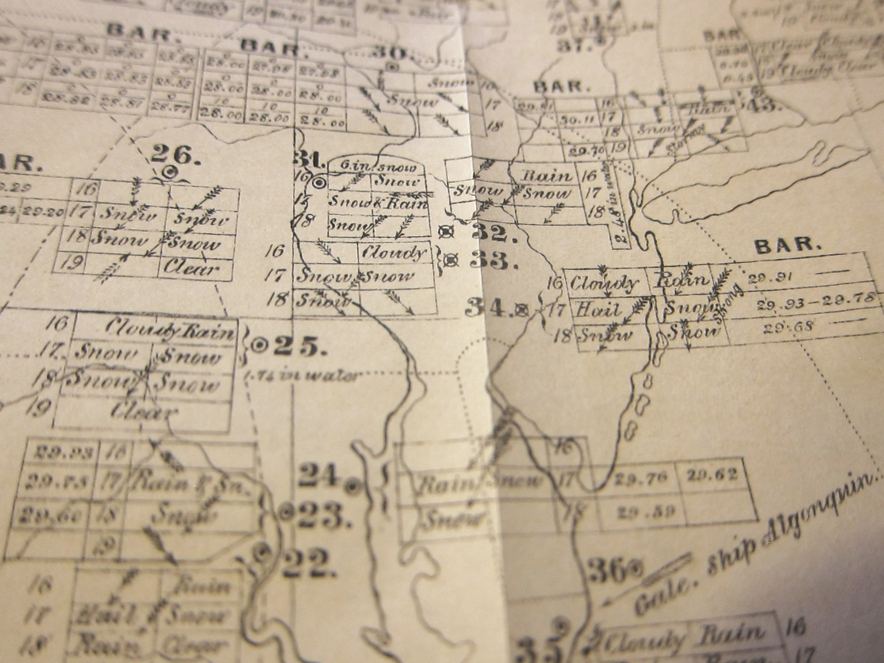
    Here’s another example of a book that I catalogued for the books-for-sale section of this blog that may be of some interest to general readers: the first weather map printed in the U.S. (1838). 

    Espy weather map _2_


  • “The Western Frontier” and How Old That Name Might Be

    JF Ptak Science Books  (From the series on “Naming Things”)

    I’m returning to this post (from ten years and 4300 posts ago) on the question of “where is the West?” because I thought I had stumbled upon a very early mention of the related idea of “the western frontier”. The phrase popped up in an article on the telegraph systems of the world (in the Journal of the Franklin Institute for 1852) and in the section on the U.S. there is a mention of telegraphs “now extending from the verge of civilization on the western frontier (east of the Rocky Mountains) to the northeast extremity of the United States”. It struck me that–I thought–I really didn’t recall seeing “western frontier” (without a capitalized “W”) all that much in the mid-19th century, let alone discussing it in terms of Colorado. 

    To check out the scarcity of this phrase I checked out the Frederick Jackson Turner piece that started this whole idea of the study of the U.S. frontiers and scanned for the elements, finding “frontier” mentioned 168 times, “west” 107 times, “western” 42 times, but with only four appearances of “western frontier”, and that usually in reference to the slavery issue. The OED was no help on this, unfortunately, and could not establish “western frontier” in the long entry on “frontier”, which has a very old and long usage in English. From there I went over to WorldCat, and checked out the appearance of “western frontier” in the titles of books printed 1800-1860, and found in the dozens of millions of book records that it seemed to occur hundreds of times. However, once getting rid of duplication, and works that had “western” and “frontier” in the title but not together, it looked as though there might only be 10 or 20, but a short look at that set showed the usage in the form I was looking for reaching back into at least the 1820’s.  So, my 1852 reference was way late, but I think I might be able to say that “western frontier” really doesn’t pick up in usage until after Turner’s 1893 piece. 

    Anyway, here’s the rest of that earlier post: