JF Ptak Science Books Post 283
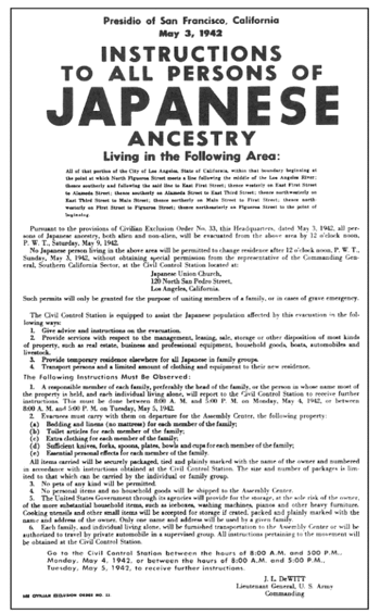 After having written a number of pots dealing with overt propaganda issues—surrender leaflets, Nazi pamphlets on the impending invasion of Germany by Poland and Czechoslovakia, American reassurances about how to survive the coming nuclear holocaust by covering yourself with table linen, British home hearts and minds campaign about how well your loved one POWs are being treated by the Germans—I thought to write a little something on the other side of propaganda, which is simply to not publish information. One case is that of the great social photographer and one of the dozen or so mainstays of perhaps the greatest American photographic collaborative ever—Historical Section of the Farm Security administrations*–Dorothea Lange. Lange worked for the FSA—which had begun life as the ominously-named Resettlement Administration, the photographic section of which was to document the good that the government was doing helping the drought and depression refugees find new life and hope elsewhere in the country outside of their own money-ravaged areas—taking mostly landscape and architectural pictures through the height of the Depression. The time that she broke character (so to speak) and made portraits produced some of the most memorable or at least famous images from this period o American history, the most outstanding of which is the five-photo series of a female bean picker and her three children who were living out of the back of their wheel-less car in a potato-less potato field in California known as the Migrant Mother. (The making of these extraordinary images is another story for another post—suffice to say that the narrative of the history of that photograph is exceptional.) I’ve always felt that the Roosevelt administration viewed this image as being just a little too much reality than it wanted to exhibit.
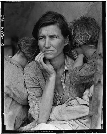
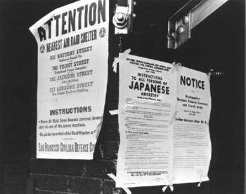
This was positively the case with Lange’s photographs of the Japanese at the Manzanar concentration camp (relocation camp) in where more than 10,000 American citizens of Japanese heritage were forced to live between 1942 and 1945. This was one of camps that were established by virtue Franklin Roosevelt’s February 1942 Executive Order 9066** to imprison more than 100,000 American (70,000 of whom were U.S. citizens, including children) for the duration of the war (compared to a few camps that were designated to hold white American citizen of the other countries that were fighting, mainly of German and Italian descent, 1,500 and 300 of whom were actually imprisoned, respectively). It was a grave, undistinguished, embarrassing move brought on by the hyper hysteria in the months following Pearl Harbor.
The Japanese at the Manzanar concentration camp were from the west coast who were bused away from their homes and lives and businesses with extremely limited notice, and who were forced to sell nearly all possessions (including lands and businesses) at what were less than fire sale prices. They were made to board buses and trains and were shipped to locations (mainly in California) where they were processed and sent further and deeper into the trying hinterlands of the west for their final destinations until the war was won. (One of the processing centers was the Santa Anita racetrack, where thousands of Japanese were sent to live for periods in converted, just-painted horse stalls.) Manzanar itself is well enough out there—removed, trying, desolate, difficult. Beautiful, too , if you weren’t in prison there. It was a high desert plateau with the snow-capped sierras, ringing the place; no grass, barely a tree, with extreme temperatures and a tough wind that was freezing in the winter and blew hot in the summer…tough enough to make it hard to keep the tar paper on the roof and sides of the thinly constructed barracks that held these people. While every other relocation camp had barbed wire and guard towers, Manzanar had none—its location was so remote and difficult that it made the construction of these inferior barriers unnecessary.
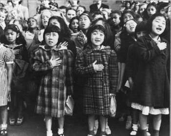
As difficult was life was at Manzanar, and having being completely torn off of the American map and their way of life, the Japanese at the camp established irrigation systems and gardens, made their own furniture from bits and scraps, established a newspaper, created a government, schools, police, and so on, making their life as orderly and hospitable as possible. Dorothea Lange was allowed, after repeated requests to the US Army, to enter the facility and make a photographic record of what she saw. And what she saw and photographed was the courage and dignity of the people that she find there in the mists of deprivation and devastation—her photos were remarkable for their sincerity and insight.
And it was for precisely this reason that almost know of them were ever seen. Bits and piece emerged here and there—four in Survey Graphic in 1942 (Vol. 31, No. 9, Sept. 1942), two others here, two others there—but they were almost entirely restricted. As a matter of fact they were stamped “Impounded”, and relegated to the future.
The FSA became the Office of War Information in 1942 as well, which might explain why this propagandistic move dismissing their existence for want of fairer reception of the American war effort at home.. It wasn’t until 1972 that 27 more of them were released and received a public showing at the Whitney in NYC in a show called Executive Order 9066, and which were reviewed in the NY Times by A.D. Coleman as “documents of such a high order that they convey the feelings of the victims as well as the facts of the crime.”
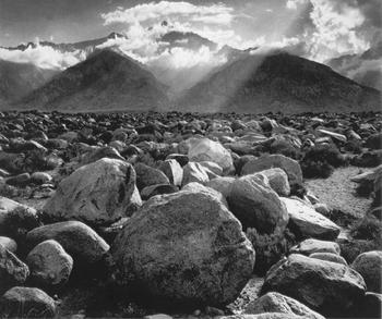
Lange wasn’t the only big-name photographer zipping around Manzanar–Ansel Adams was there, too, as a friend of the camp administrator. Adams had free access to the camp, and could basically come and go as he pleased, which didn’t sit well with Lange, who had a hard go of her permissions with the Army. It was also something that she never let go of, either, as the Adams photos really didn’t get into the Being of the place like Lange’s did. Actually, one of the great, iconic images made by Adams comes from this period, and as it turns out, its one of those odd sorts of photos that turns in the opposite direction of what the photographer was there “for”. Mount Williamson is just a drop-dead shot to be sure. It is also an image of what the Japanese in the concentration camp were looking out at. Adams turns his camera around, around from the disgrace, and takes one of his greatest images. (I’ve listened to my wife Patti Digh, who is an (excellent) photographer, talk about photographers “making” photographs; I’m sure that before her I used “taking” and “making” photographs interchangeably. But “making” it should be, as you’re not owning or lifting the image away.) In this case, however, as monumental as Adams was or is, he definitely “took” this one. Stole it.
An excellent book on these photos is found in Linda Gordon and Gary Okihiro, Impounded, Dorothea Lange and the Censored Images of Japanese American Internment (W.W. Norton, 2006).
*This incredible group included: Arthur Rothstein, Carl Mydans (up to the summer of 1936), Walker Evans (up to September 1937) Ben Shahn, Dorothea Lange (with interruptions up to 1942). Russell Lee, Marion Post Wolcott, John Vachon, Jack Delano, John Collier. This group produced upwards of 270,000 negatives, with 77,000 or so prints available at the Prints and Photographs room of the Library of Congress in a row of double-backed file cabinets. Many thousands are available online at loc.gov I am told by a reliable historian that I am wrong in thinking that Lange was fired because of her too-intolerably human photos, but for budgetary problems.
.
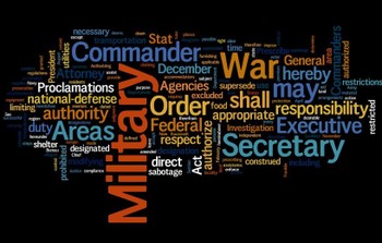
**The following is the text of 9066, which basically authorized a 60-mile swath of the Pacific Coast as a military zone subject to national defense requirements, the principal object of which was to remove all Japanese residents from the area for fear of them being enemy agents and saboteurs. To accompany this I mad a WORDLE text map of the document, just to see what popped up.
 Executive Order No. 9066
The President, Executive Order
Authorizing the Secretary of War to Prescribe Military Areas
Whereas the successful prosecution of the war requires every possible protection against espionage and against sabotage to national-defense material, national-defense premises, and national-defense utilities as defined in Section 4, Act of April 20, 1918, 40 Stat. 533, as amended by the Act of November 30, 1940, 54 Stat. 1220, and the Act of August 21, 1941, 55 Stat. 655 (U.S.C., Title 50, Sec. 104);
Now, therefore, by virtue of the authority vested in me as President of the United States, and Commander in Chief of the Army and Navy, I hereby authorize and direct the Secretary of War, and the Military Commanders whom he may from time to time designate, whenever he or any designated Commander deems such action necessary or desirable, to prescribe military areas in such places and of such extent as he or the appropriate Military Commander may determine, from which any or all persons may be excluded, and with respect to which, the right of any person to enter, remain in, or leave shall be subject to whatever restrictions the Secretary of War or the appropriate Military Commander may impose in his discretion. The Secretary of War is hereby authorized to provide for residents of any such area who are excluded there from, such transportation, food, shelter, and other accommodations as may be necessary, in the judgment of the Secretary of War or the said Military Commander, and until other arrangements are made, to accomplish the purpose of this order. The designation of military areas in any region or locality shall supersede designations of prohibited and restricted areas by the Attorney General under the Proclamations of December 7 and 8, 1941, and shall supersede the responsibility and authority of the Attorney General under the said Proclamations in respect of such prohibited and restricted areas.
I hereby further authorize and direct the Secretary of War and the said Military Commanders to take such other steps as he or the appropriate Military Commander may deem advisable to enforce compliance with the restrictions applicable to each Military area hereinabove authorized to be designated, including the use of Federal troops and other Federal Agencies, with authority to accept assistance of state and local agencies.
I hereby further authorize and direct all Executive Departments, independent establishments and other Federal Agencies, to assist the Secretary of War or the said Military Commanders in carrying out this Executive Order, including the furnishing of medical aid, hospitalization, food, clothing, transportation, use of land, shelter, and other supplies, equipment, utilities, facilities, and services.
This order shall not be construed as modifying or limiting in any way the authority heretofore granted under Executive Order No. 8972, dated December 12, 1941, nor shall it be construed as limiting or modifying the duty and responsibility of the Federal Bureau of Investigation, with respect to the investigation of alleged acts of sabotage or the duty and responsibility of the Attorney General and the Department of Justice under the Proclamations of December 7 and 8, 1941, prescribing regulations for the conduct and control of alien enemies, except as such duty and responsibility is superseded by the designation of military areas hereunder.
Franklin D. Roosevelt
The White House,
February 19, 1942.
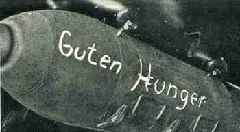 In an earlier post (The Most LIterary Fireworks Catalog Ever Published? The Naming of Explosions) I wrote a little bit about names found on shells and the naming of explosions. The chances for adding to this category are slim, given the ephemeral nature of the item of discussion–I did however stumble upon this Food Bomb, found in the 25 April 1942 issue of The Illustrated London News. “Guten Hunger”, the inscription on this “bomb” (basically “good appetite” or “eat well” or “down the hatch”) was actually “not a weapon of destruction, but an enormous food container” that was going to be dropped on the German soldiers on some slender part of the Eastern Front. In April the situation was turning now away for the Germans with the Soviet counter offensive, and it was still cold. Something like 3 million German soldiers would be awarded the service medal for the Winterschlacht im Osten 1941/42–not many of them would get to look at it after 1945. The campaign in the east against their former allies started on 7 June 1941 (and named variously die Ostfront 1941-1945, der Rußlandfeldzug 1941-1945 (Russian campaign) or der Ostfeldzug 1941-1945 (Eastern Campaign)) and lasted to mid-May, 1945, when the campaign line shrunk from as far away as Moscow back down to east Berlin.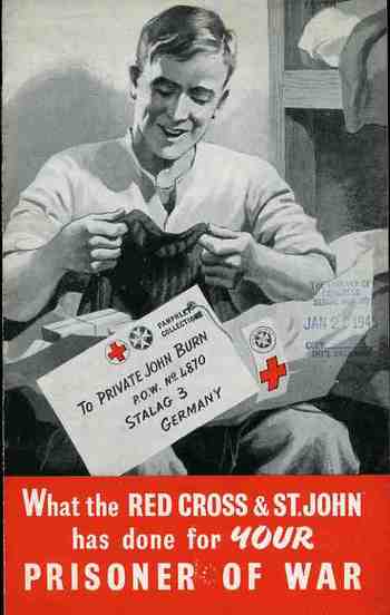
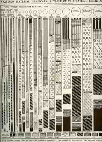 This dense, complicated table showing the distribution of strategic raw materials (published in The Illustrated London News 3 August 1940) I is a decent example of how not to display data. Perhaps there’s just too many variables to try to control here in one visual display: it tracks twenty raw materials by percentage of access for thirteen different countries, with the entire graph being displayed in a sort-of progression according to metric tons of material. Maybe it’s the varying widths of the bars representing the material, maybe it’s the complex designs distinguishing the countries, and maybe its just too many lines. The only time this really works for relatively-offhand use is when you’re looking for one country in particular, and then the eye allows it self to just concentrate on the solid black (Germany) or the stars in a bar (U.S.) When the graph is used in this manner it displays rather quickly that Nazi Germany doesn’t control a whole lot of the combined tonnage of the twenty strategic materials, which was a particularly good thing for the general reading population in the Allied world to see, because the war was not going so well at this early stage. (At this point in the war—less than a year old now in Europe—the Battle of Britain had begun though it was still weeks away from when the massive Blitz begins, and Hitler had just toured Paris…it was not a good time for Britain, and a worse time for France. The Soviet Union is listed still with the Axis as it was still 10 months away from being attacked, Hitler turning on his allies in Operation Barbarosa in June 1941.)
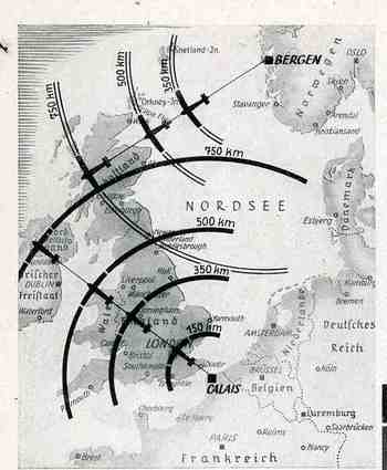
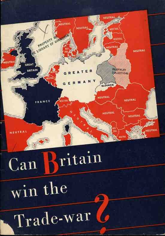
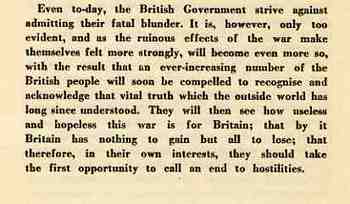
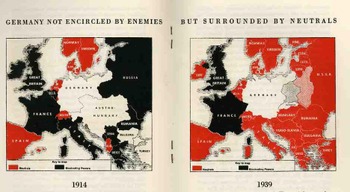 After a dozen pages of making the case against the British position in being able to take care of itself, there is this folding quantitative display, making a diametrical-pictorial presentation of the British failings. The Nazis show that they overpower the British in the ability to supply itself with grain, flour, meat, cooking fat, cheese, eggs, sugar and vegetables–in every area, in fact, except for fish.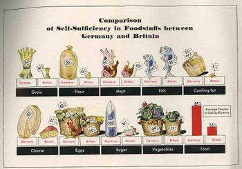
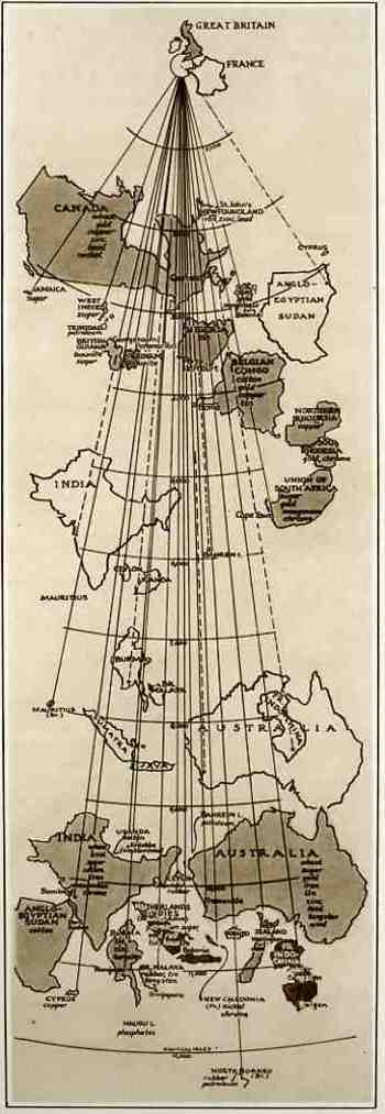 This map comes to us from The Illustrated London News, 3 August 1940, which reproduced it from an article in Fortune Magazine. Though it looks oddly wrong from the outset, it really is pretty lucid–elegant, even–once you understand its purpose. And the purpose of this map was to show the distances that the goods and raw materials from the British Empire (and from the possessions of France) had to travel via the then-closed Suez Canal route versus the new routes “not open to enemy interference” to Great Britain. Countries depicted in outline show the distance via Suez while the same country depicted in shade show the new, longer, non-Suez route. Ever stiff lipped, the Brits announced that even though some of their major natural resources are coming from these vastly removed areas, “even with the fall of France, the British Empire and its allies remain an economically self-contained and immensely powerful war unit, and still control the great part of the world production of some vital commodities…” I’m not sure why, exactly, that it was necessary to display this map to the public eye, what with England under assault in the Battle of Britain (the Nazis extending their aerial assault in preparation for Operation Sealion), the loss of France, and the nearly-there Nazi blockade of English waters. Perhaps it was drawn to show that even though the material was coming from the same places that were now further away, they were still getting there.