A Daily History of Holes, Dots, Lines, Science, History, Math, Physics, Art, the Unintentional Absurd, Architecture, Maps, Data Visualization, Blank and Missing Things, and so on. |1.6 million words, 7500 images, 4.9 million hits| Press & appearances in The Times, Le Figaro, Mensa, The Economist, The Guardian, Discovery News, Slate, Le Monde, Sci American Blogs, Le Pont, and many other places… 5000+ total posts since 2008.

Category: Militaria

  • Radio HATE, Stuttgart, 1939/1940

    JF Ptak Science Books    Quick Post
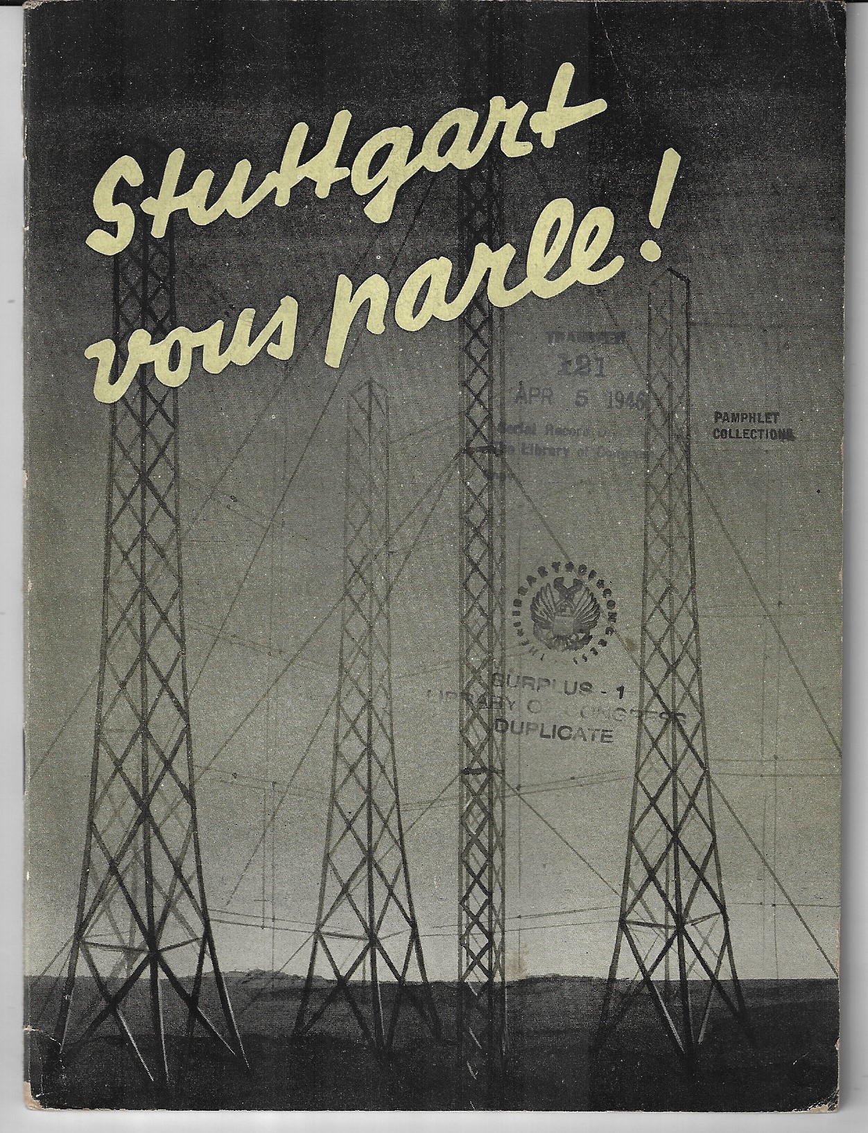
    Books covers stuttgart radioThe pamphlet Stuttgart vous parle! (ca. 1941) is nearly the same name as the Stuttgart radio station/program which was a propaganda arm of the Nazis, broadcasting into France in 1939 and 1940, and progressively less so after the French capitulation. Goebbels was very thorough in controlling the radio and television programming/writing/distribution in Germany, as well as creating propaganda broadcasts into Nazi-occupied countries. There is very little question about where this pamphlet is heading, its pro-German, appeasement, anti-Ally, anti-USSR, pro-Vichy sentiments being very clear.  For an example, here’s a bit from page 30, which recommends the immutability of Mein Kampf:

           “Si en quelques jours, devant l’evidence des menaces et des pieges que l’Angleterre lui tendait, le Reich s’est reconcilie avec Moscou, il faut admettre qu’il n’existe pas d’idees preconcues dans la mentalite du Fuhrer et qu’il dirige la politique allemande au mieux des eventualites. Que ces quelques explications vous fassent saisir ce qu’il y a d’immuable dans mein kampf et ce qu’il s’y trouve de momentane, c’esttout ce que nons esperions aujourd’hui.”

    Experts state that the principal broadcaster for the radio show was Paul Ferdonnet. Captured at the end of the war in Germany, Ferdonnet was tried as a war criminal, a charge he denied, saying that it was not he who was the broadcaster and so on. The court found otherwise, and Ferdonnet (“le traître de Stuttgart”) was convicted and executed in short order, not living to the end of the summer of 1945.

    [There is also a publication Stuttgart vous Parle! Les Discours de Paul Ferdonnet Diffuses vers la France a partir de la Radio Allemande en 1939-1940 (edited by VHO), which seems to state in certain terms that Ferdonnet was indeed guilty of war crimes for his participation in pro-Nazi propaganda. It is also interesting to note that  Stuttgart vous parle!  has no identifying marks for publisher, printer, or place of publication. Nothing.]

    On the one hand, free speech is a big deal; but free speech does not extend to shouting “Fire!” in a crowded theater. (I’m slipping up on the name right now, but there was a case back in the ‘teens of 100+ people, mostly women and children, family of union members, who were meeting in a hall when an anti-union thug yelled “fire!”, starting a deadly stampede.) Working away at the psyche of a people trying to defend itself, trying to survive, is very nasty and murderous stuff. Ferdonnet was executed for this action, a fate escaped by E. Pound for his Fascist broadcasts in Italy during WWII…but all of that is another story. 
    ·Posted by :

    ·in:


  • First Use of an Airplane in “War Conditions” 1911

    JF Ptak Science Books  Quick Post

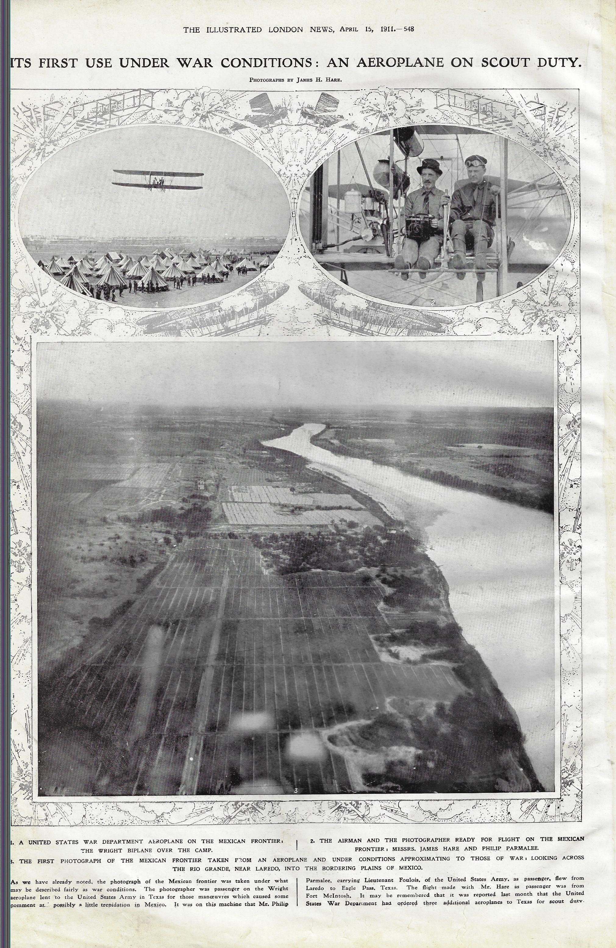
    I am not an historian of aviation, though the item I just found grazing through a volume of the Illustrated London News for 1911 may be one of the asterixed poor Roger Maris footnotes in the history of military flight. The title of the series of pictures–“Its First Use Under War Conditions–an Aeroplane on Scout Duty” appeared in the ILN issue for 15 April, and referred to flights being made over the U.S./Mexican border during the Border War of 1910-1919, (Poncho Villa, Mexican Revolution, J.J. Pershing, and all that). The writer didn’t want to go so far as to state that these were actual war conditions in which the plane was being flown, remarking that they were “Taken under what might be described fairly as war conditions”. So, it seems as though the title is accurate in a restricted way.

    I am not sure when the first use of a plane was as a scout vehicle during wartime, though certainly the first use of an airplane to deliver a bomb in a battle during actual wartime occurred seven months later. “During fighting in November 1911 between Italy and forces loyal to the Turkish, Ottoman Empire, Lieutenant Giulio Gavotti wrote in a letter to his father: ‘Today I have decided to try to throw bombs from the aeroplane. ‘It is the first time that we will try this and if I succeed, I will be really pleased to be the first person to do it.’ “–Alan Johnston, BBC News, “Libya 1911: How an Italian pilot began the air war era”

    And indeed he did, and he was.

    ILN 1911 airplane war use

    ·Posted by :

    ·in:

    —

  • Looking for Bastogne (1939)

    JF Ptak Science Books   Quick Post

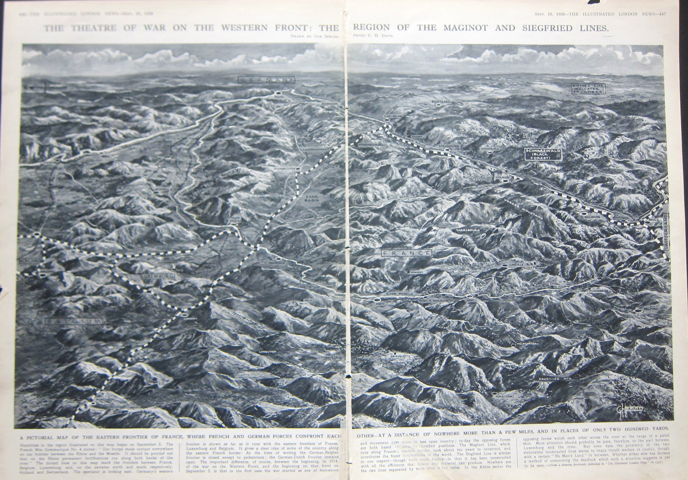
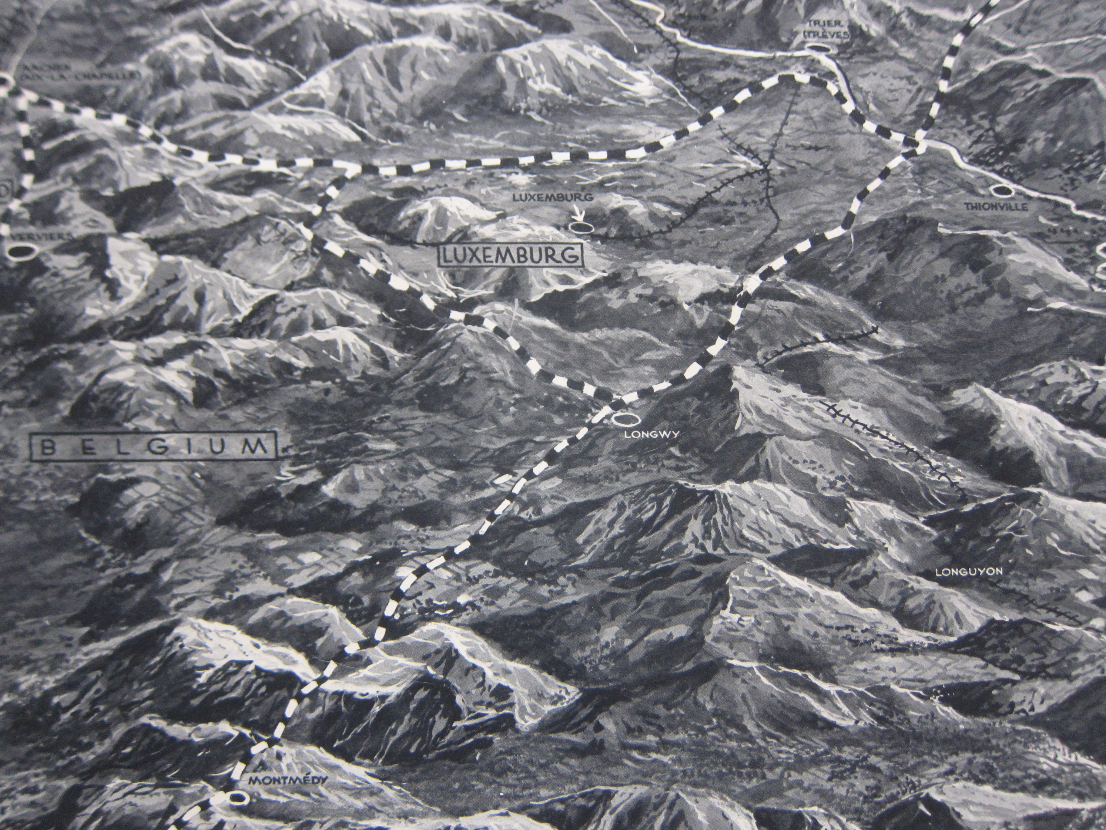
    This double-page map from Illustrated London News caught my eye–it shows “the theatre of war on the Western Front” at the end of the second week of the European war, 16 September, 1939, just five days after the war had been freshly defined for the first time as “World War II”. (From the OED: “1939   Time 11 Sept. 38/1   ‘Some of the diplomatic juggling which last week ended in World War II was old-fashioned international jockeying for power.’”) It is an interesting oblique view (north to the left) created by the great ILN illustrator, George H. Davis, showing the borderlands of Belgium, Luxenbourg, France, and Germany, the first three soon to be overrun. The map does seem to present a good bird’s eye for the region, and what I set out to find was the Ardennes–soon to come to life again as an unlikely entry point of attack to France, and then again to the Germans come Christmastime 1944.  Part of the Ardennes is seen at the lower left, though not identified. Triangulating the towens of Longwy, Longyuon, and Luxembourg City, I’d place the town of Bastogne at about the “G” in the title for “Belgium”.  The town isn’t on th emap now, but in five years, everyone will know where it is, named or not.  

    Maps WWII ILN 1939 Ardennes

    IMG_9195


  • A Reverse D-Day, 1803

    JF Ptak Science Books  Post 2746  

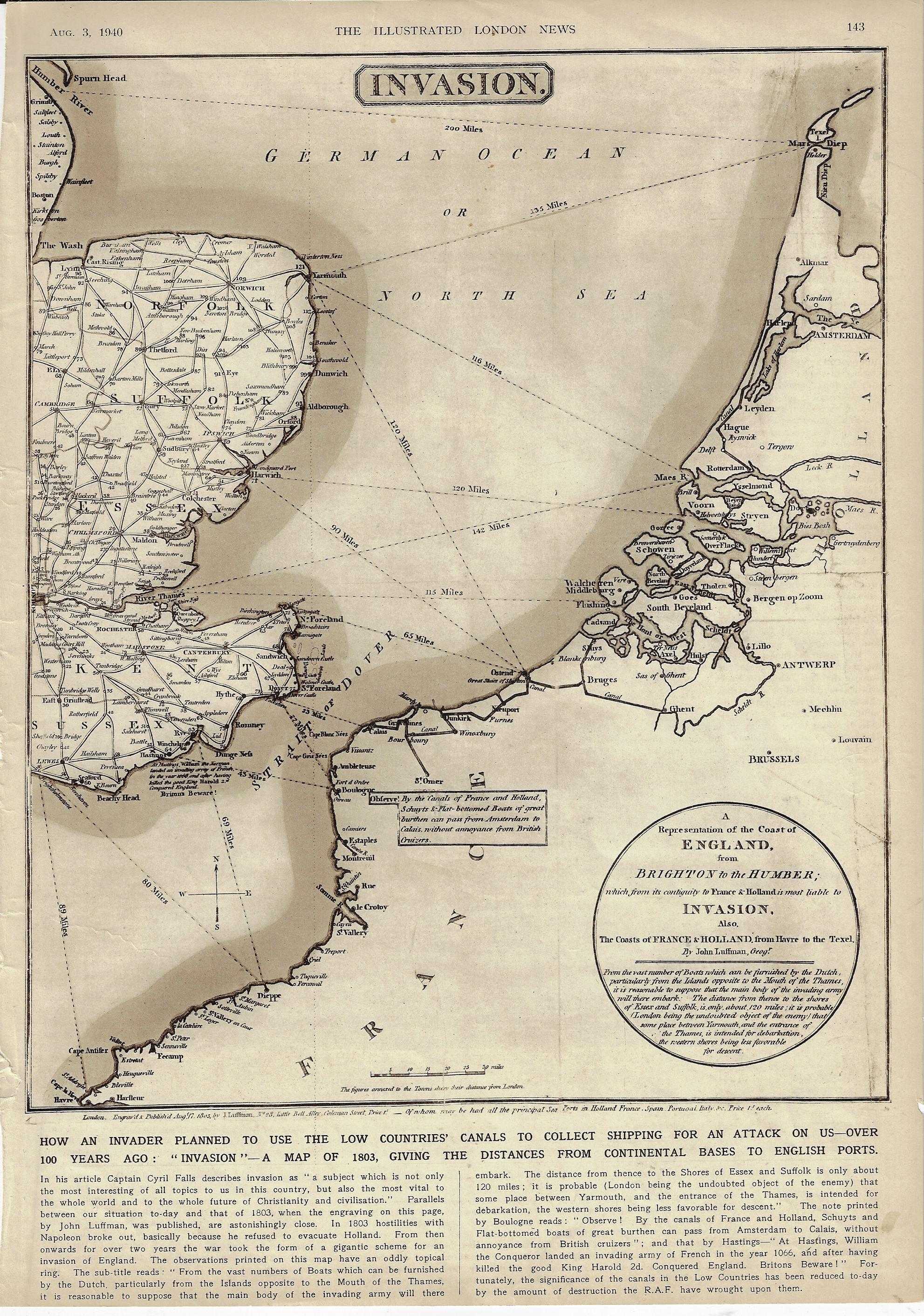
    There have been many D-Days in the history military terminology, but for almost everyone it refers to the Allied invasion of Normandy on 6 June 1944. In 1803 when Napoleon was in high form and making his way through Europe there was a wide concern in England that he would attempt a cross-channel attack and invade the country.  Which leads us to this map1 that I just found (again) in the Illustrated London News for 3 August 1940–the map entitled “Invasion”, showing the possible routes that the enemy might take in crossing the channel. 

    This was published at the time where the very real threat of invasion loomed like an angry low-ceiling mammatus cumulus, ready to break. Belgium, Luxembourg, and the Netherlands were defeated three months earlier, Dunkirk had just been sustained and the evacuation completed two months earlier; one month later, in July, the Battle of Britain had begun. It was not the French this time, but Germany–though the French had just weeks earlier surrendered without much fight and signed a disgraceful armistice with Germany, further weakening the very bad position of Great Britain. France was invaded in May and surrendered in June, an incredible collapse of what had just a few years earlier been Europe’s leading army, encamped behind the instantly obsolete Maginot Line.  It would be another 16 months before the U.S. entered the war, and another 46 months before the Normandy Invasion would cement the endgame for the war in Europe.  There was one gigantic good thing that happened in May–Winston Churchill became the Prime Minister. 

    Perhaps the editors at ILN sought to show the stoic Brits that they had been “there” (but now “here”) before, and nothing came of the Napoleonic threat. Of course there is almost no discussion of earlier attempts at invasion–though there is some fine print on the map quietly shouting “Beware Britons” about 1066 and all that.

    The odd thing about this map–made by J. Luffman and published 17 August 1803–is that I haven’t been able to find it online. The mapforum group has a very interesting entry on Luffman as well as images of a different map showing a much greater area.2 And so here it is–perhaps I’ve missed the thing, somewhere, but I just haven’t been able to find it. 

    The Luffman map comes very close to concentrating on the WWII D-Day theater of operations, the map extending as far to the SW as Le Havre, which misses by just 10 miles the Eastern Task Force beachhead at Sword.  

    Map invasion 1940

    Notes:


  • Data Visualization of Comparative Naval Strengths, 1929

    JF Ptak Science Books  Quick Post

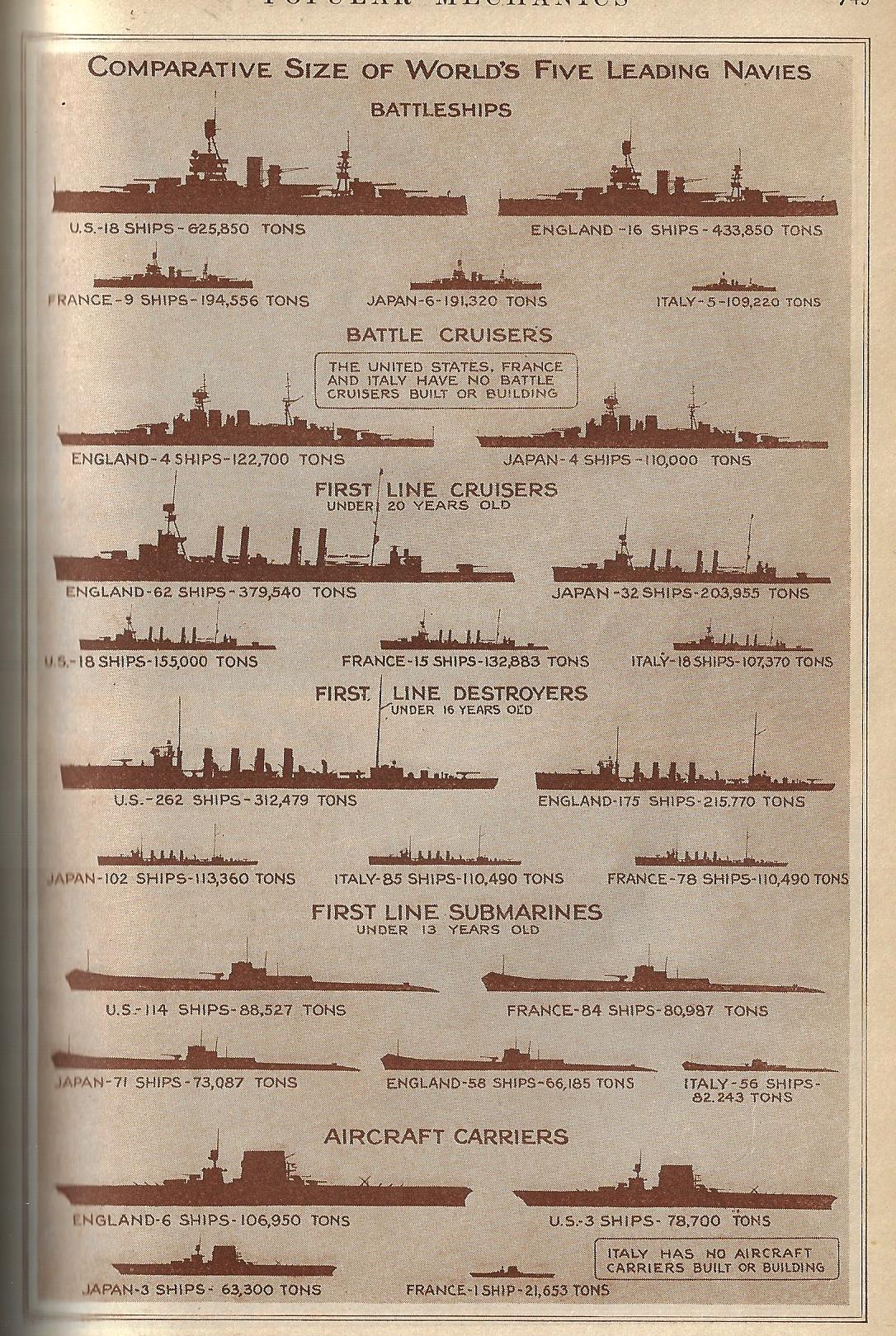
    There are many more complex, complicated, and data-rich displays like this one presented on this blog (just access the “Display of Quantitative Info” section), but there is a certain attraction with this simple-ish one. It is the design of W.R. Robinson–an artist with a fine touch, which is on display here more for the employment of empty space than lines–and gets across the information pretty easily and quickly. In any event, here it is, displaying the relative strengths of the world’s navies ten years after the end of WWI, which at that point was still the great War, “World War I” waiting to be invented in another ten years when there was a needed distinction between that world war and the newest world war.  

    Pop Mech 1929 dataviz navy strength

    [Image source: Popular Mechanics, June, 1929.]


  • Cross Section and Cockpit of a Hawker Hurricane, 1939 and 1942

    JF Ptak Science Books  Quick Post 

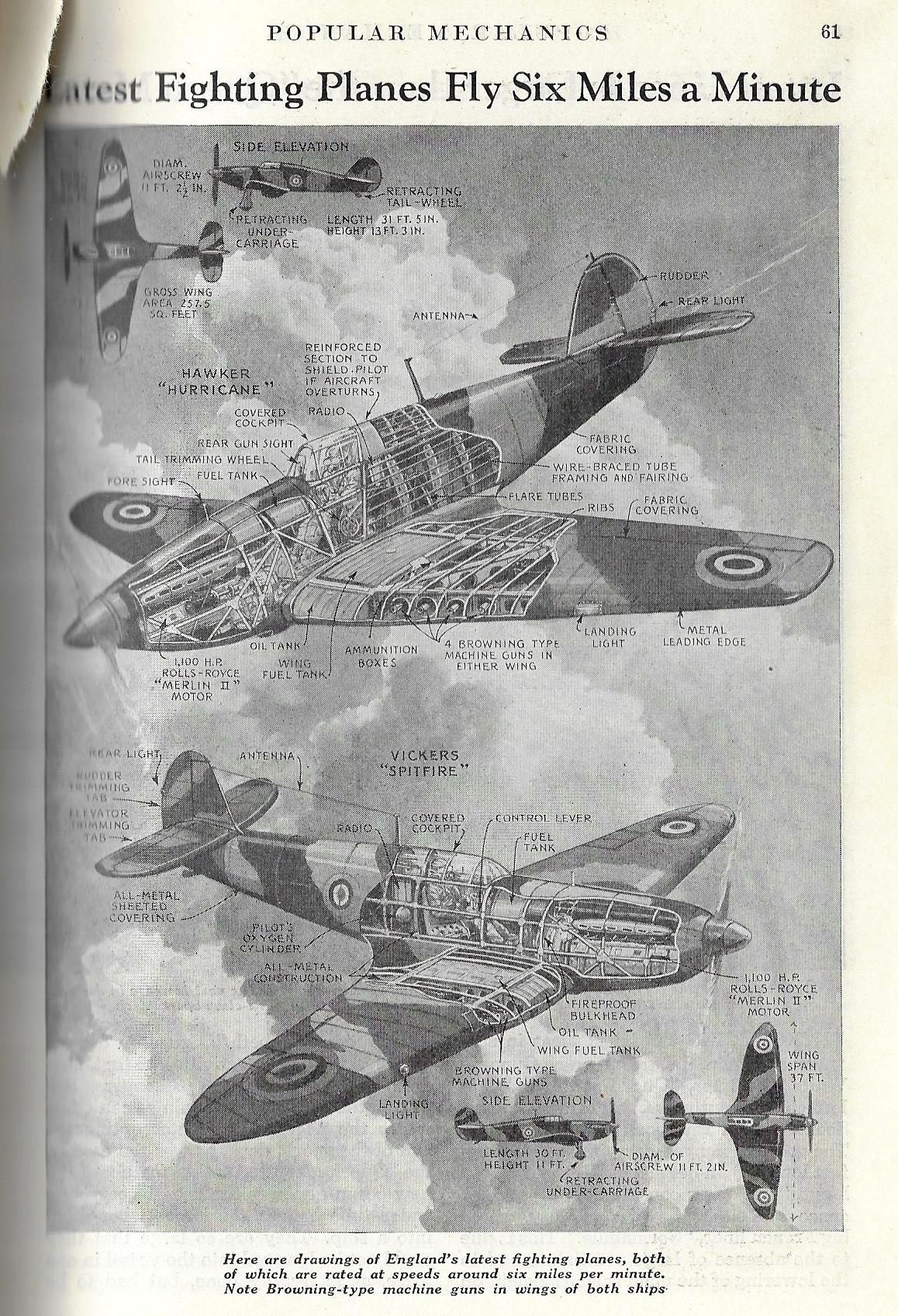
    I would say that there are perhaps 100 good, solid (mostly technical) cross sections on this blog, and to that number I’d like to add two more. the first features the Hawker Hurricane and the beautiful and winning Vickers Spitfire–two of the most important aircraft of the war and backbone of the RAF, and it appears as a short article right before the start of the European part of WWII in Popular Mechanics for January 1939.

    Cross section 1939 Spitfire Hurricane

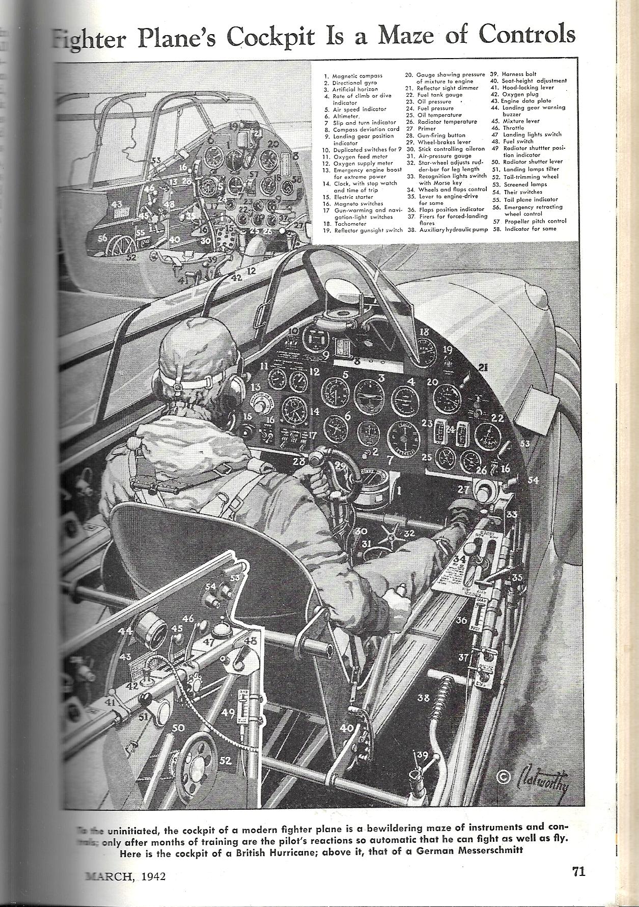
    This second image–barely a cross-section as things go but it does serve our purpose–comes via the cross-section-dependable Popular Mechanics for April 1942, and shows the cockpit controls for a British Hurricane as well as a smaller image for a German Messerschmidt. (Click and click again to greatly enlarge this image for the small print.)


    Cross section Pop Mech 1942 Hurricane aircraft


  • Iconic WWII Propaganda–Great Britain, 1940 (“Careless Talk Costs Lives”)

    JF Ptak Science Books    Post 2727

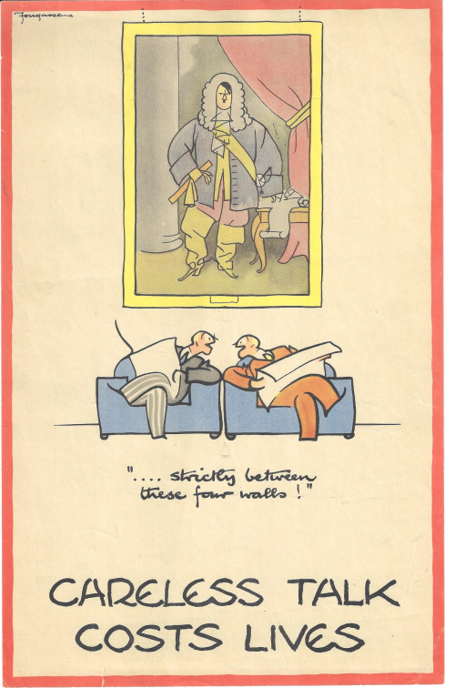
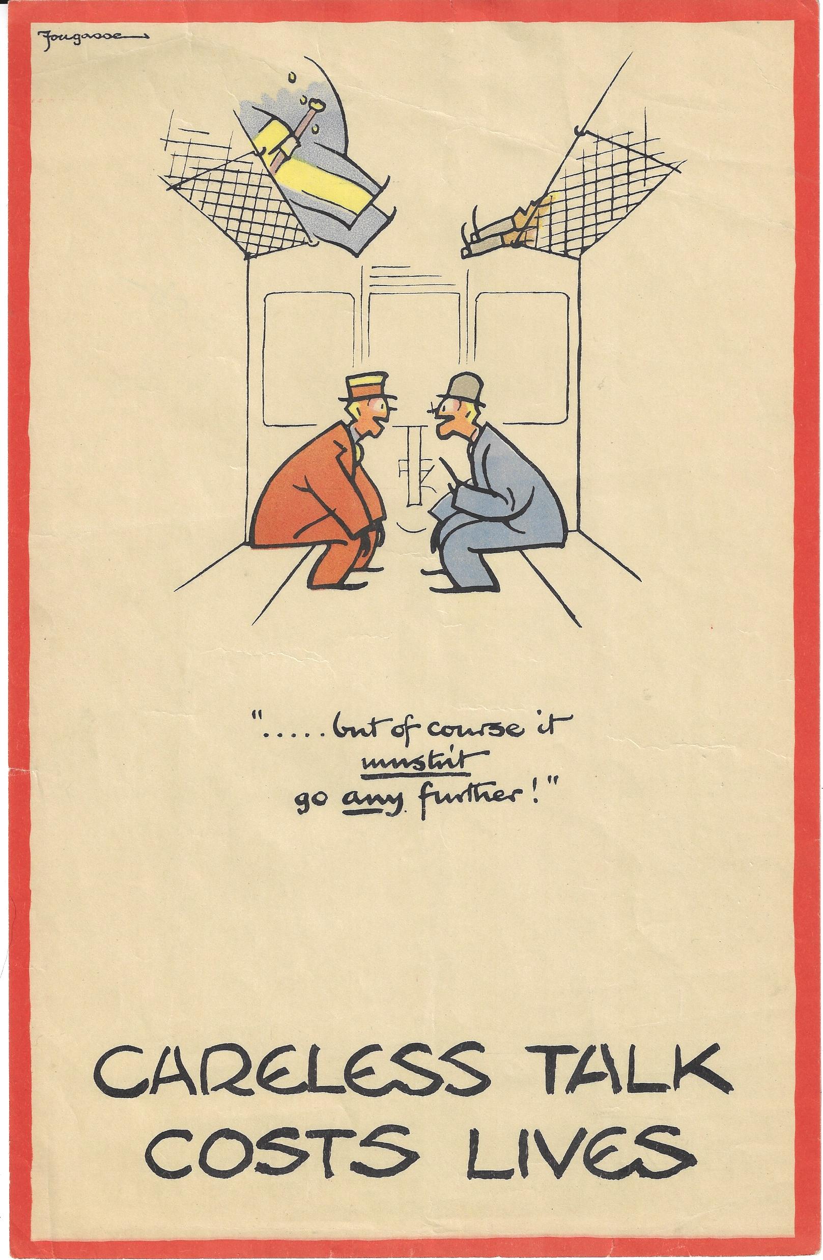
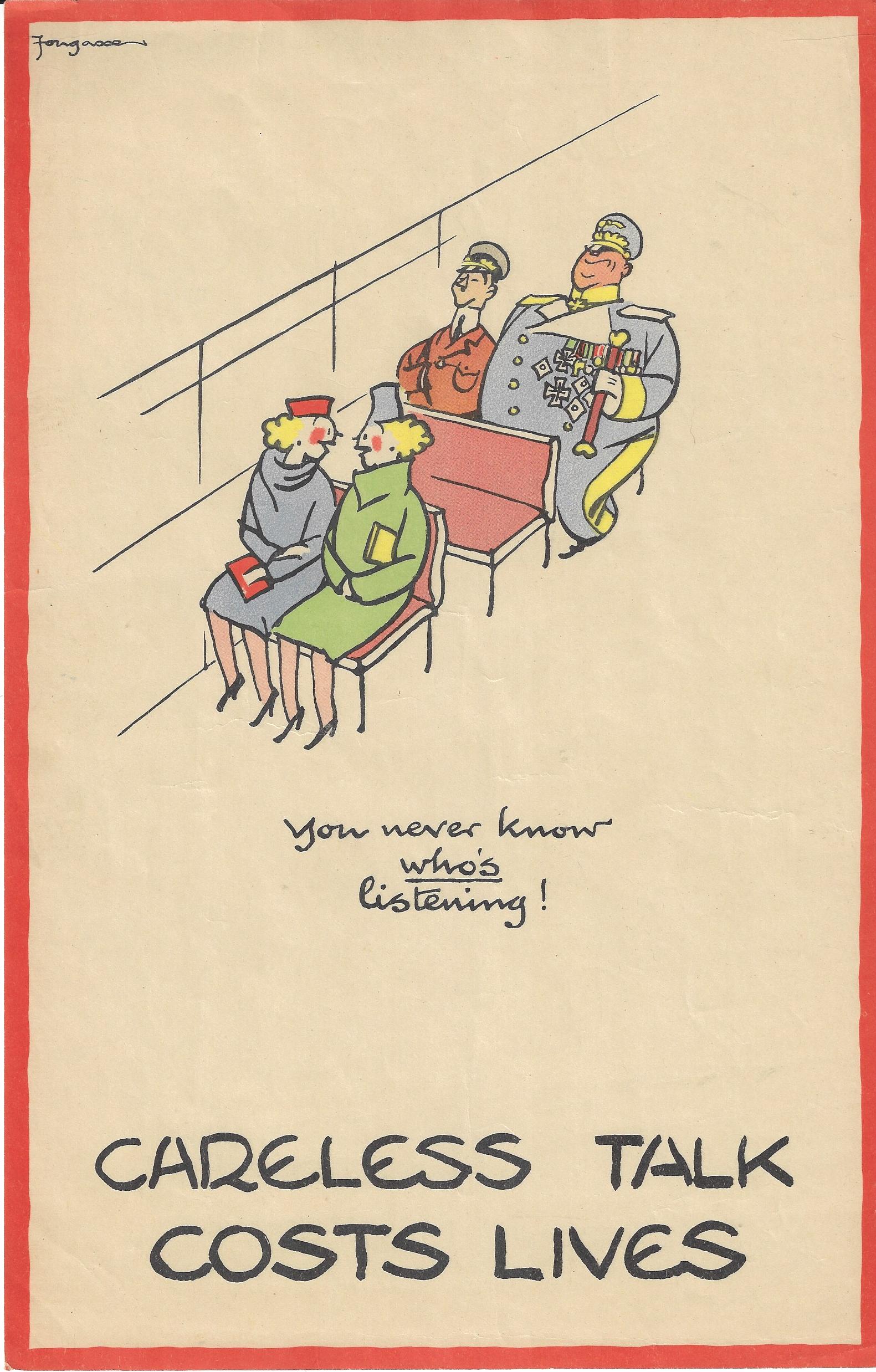
    I found these images years and years ago, and evidently had forgotten them–they surface yesterday from a long slumber, and immediately put me into mind of the very real hearst and minds campaign and of keeping secrets secret in the terrible and great struggle in the U.K. in 1940.  These are four of eight posters in the very popular “Careless Talk Costs Lives” wartime propaganda series issued by the Ministry of Information and printed in 19401. They are the very stylized work of the illustrator “Fougasse”, who was Cyril Kenneth Bird, (1887-1965), an illustrator for Punch (from 1937 to 1949) and other journals and magazines, and also a wounded vet of Gallipoli in the First War. 

    The series in general depicts people sharing a piece of possibly sensitive information that in the wrong hands and together with other pieces of info could reveal devastating secrets—and in each case there are figures lurking/loitering/disguised in the background waiting to collect the data, and generally a poorly disguised Hitler or Goering or both. Fougasse was able to make his message immediately memorable and understood because I think of his understated over-the-top visual humor. The images were funny, but the message was deadly serious. Also, you really didn’t even need to read the text to understand the message. (This is in the same vein as some of Thomas Nast’s finest work, conveying social content and a political message to the illiterate, making his devastating (and usually highly textual) cartoons understandable without needing to read them.) 

    (1) “Strictly Between Four Walls”.  In this poster (made a convenient size to be useful in virtually any small area and also abiding the wartime paper shortage) we see two men in big club chairs about to share some bit while the artwork-ensconced Hitler waits to hear the interesting parts. 

    Fougasse but of course it mustnt


    ·Posted by :

    ·in:

    —

  • Early Aerial Bombing, 1916

    JF Ptak Science Books  Quick Post

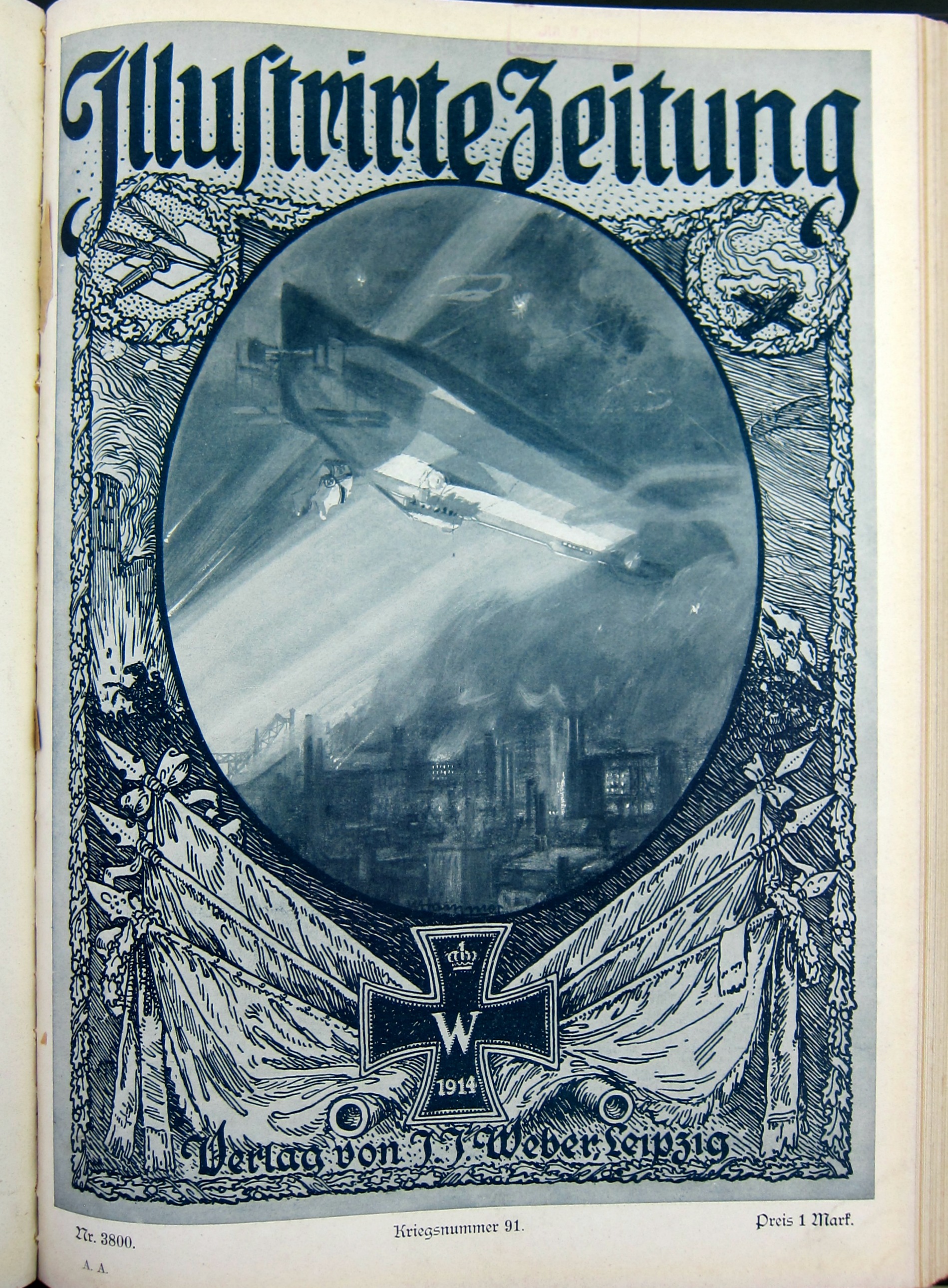
    This issue of Illustrirte Zeitung (Leipzig) was published 27 April 1916 (volume 146, number 3800) and features an early-ish image of an airship bombing a city. The first time this occurred in WWI was in the autumn of 1914, at Liege, with a bombing campaign initiated against London in January 1915.  (The first aerial bombing seems to have been during the first Italian War of Independence and used by the Austrians from a  balloon against Venice in 1849; while this 1916 bombing occurred a few years after the first bomb was dropped from a heavier-than-air aircraft during the Italo-Turkish War on 1 November 1911, the Italians this time delivering the blow in Tripoli.) The scene here illustrates an airship in flight over a very industrialized section of a city, perhaps to drive home a propaganda point that bombing was accurate enough to be strategic and also that targets were industries and not general populations. 

    • “Airships made about 51 bombing raids on England during the war. These killed 557 and injured another 1,358 people. More than 5,000 bombs were dropped on towns across Britain, causing £1.5 million in damage. 84 airships took part, of which 30 were either shot down or lost in accidents. Aeroplanes carried out 27 raids, dropping 246,774 lb (111,935 kg) of bombs for the loss of 62 aircraft, resulting in ground casualties of 835 dead, 1,972 injured and £1,418,272 of material damage.”–Wikipedia

    Bombing 1914


    ·Posted by :

    ·in:

    —

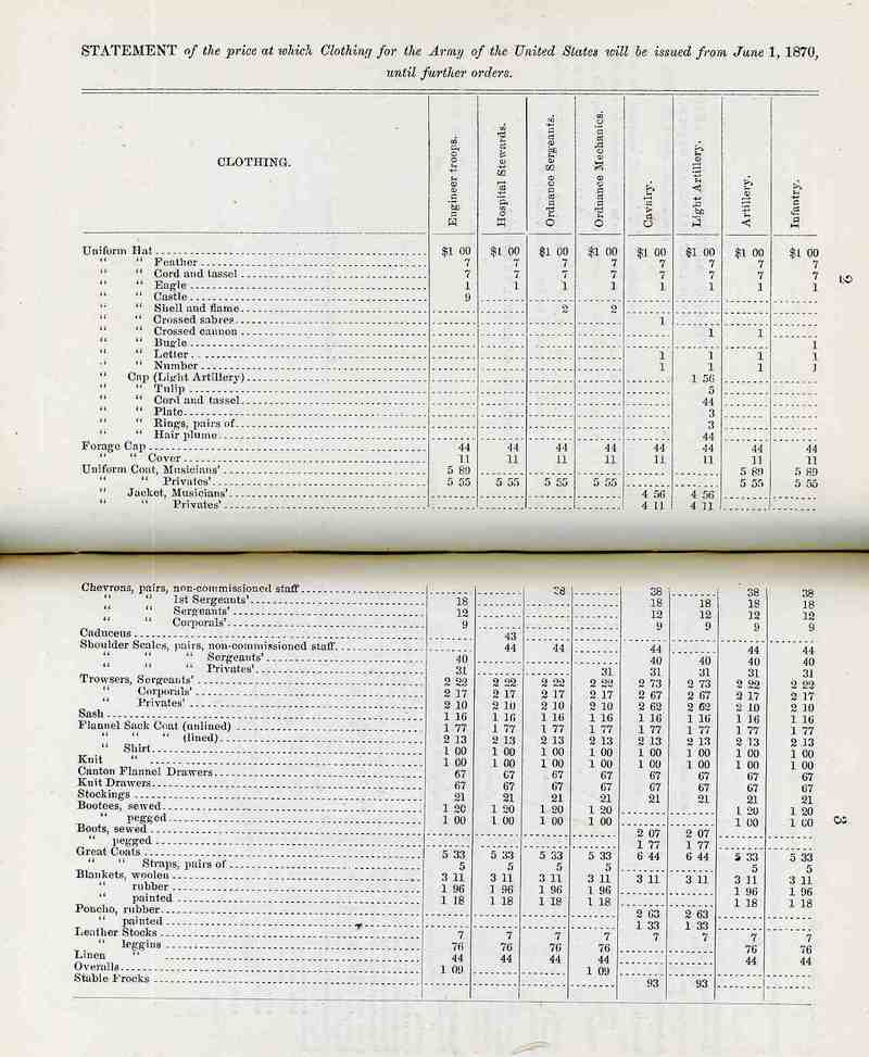
  • Money: How Much did a Sergeant’s Chevrons Cost in 1870?

    JF Ptak Science Books  Post 2735

    Here’s an interesting list of prices, outfitting U.S. Army personnel stem to stern so to speak. The major thing here that I do not know is who it was paying these prices–was this the cost to the government in supplying these goods to soldiers? Or are these the prices that soldiers paid for replacement goods? Or did new recruits pay for their uniforms with the costs deducted from future pay?  My suspicion is that these are the costs to the government in outfitting the army, plus arms and munitions and food and all of the rest.  Interesting numbers, if you can use them.  

    There were a number of things here that cost only a penny, like the eagle emblem for a private’s uniform hat, while the most expensive items listed here for soldier accoutrement were the cavalryman’s greatcoat ($6.49) and the musician’s uniform (at $5.89). 

    Some other interesting bits:

    • Underwear, 67 cents
    • Mess can, 22 cents
    • Standard tent, $17.11
    • Sash, $1.21
    • Shovel, 59 cents
    • Sergeant’s trousers, $2.32 (for the corporal, $2.17, and the private, $2.10)
    • Stockings, 21 cents
    • Hospital tent, complete (though without medical equipment) $106
    • Garrison flag, $48

    What does it mean for the average person to spend 5 bucks in 1870?  How does that translate to current currency?  There’s a ton of difficulty in doing that, but one simple way that gives at least some clue to understand the value of those dollars is to put it into the context of how much of a weekly salary something might absorb for a worker at that time. For example, here are some weekly salaries for a few professions:

    • rag cutters at a paper mill, $7.45 (male) and $4.00 (female)
    • blacksmith at iron works, %15
    • “forger of nuts” in carriage works, $20
    • forgers of lightning rods, $10
    • coopers in lime works, $12
    • sail makers $10
    • laborer in a varnish works, $11
    • shoemaker, $14

    These are average weeklies, and would varying according to location (with high and sometimes substantially so being paid in the West and unusual destination points). So in general, a $2 expense is about a day’s labor for a 6-day/10-12 hour week, which means it is not like buying a cup of coffee. This is simplistic, but useful.

    [Source for the data above: the very interesting and exhaustively-titled Special report on immigration : accompanying information for immigrants relative to the prices and rentals of land, the staple products, facilities of access to market, cost of farm stock, kind of labor in demand in the western and southern states, etc., etc., to which are appended tables showing the average weekly wages paid in the several states and sections for factory, mechanical, and farm labor, the cost of provisions, groceries, dry goods, and house rent in the various manufacturing districts of the country, in the year 1869-’70, by Edward Young, chief of the Bureau of Statistics. https://babel.hathitrust.org/cgi/pt?id=hvd.32044024335481;view=1up;seq=248

    And the army?  Here are some figures I found for Union pay during the Civil War, per month:

    • Private and Corporal, $13
    • 1st sergeant, $20
    • 1st Lieutenant, $105.50
    • Captain, $115.50
    • Major $169
    • Lt Colonel, $181.
    • Colonel $212, Brigadier General, $315

    [Source: Civil War Trust https://www.civilwar.org/learn/articles/military-pay]


    (Click for a larger, readable image.)

    Sergeant shirt


    ·Posted by :

    ·in:

    —

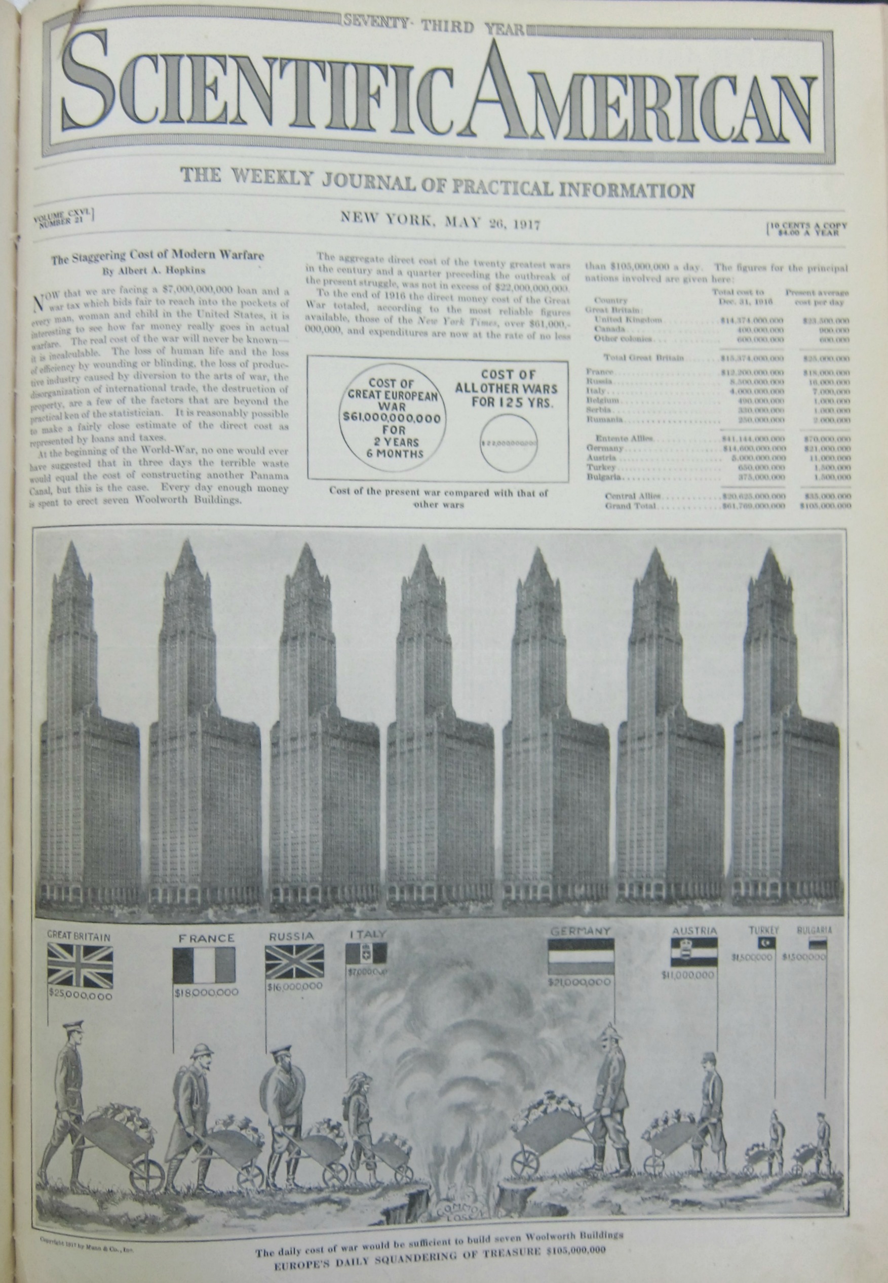
  • Data Visualization and Enormity–the Cost of War in Terms of Iconic Buildings (1917 and 2017)

    JF Ptak Science Books  Post 2733

    The first thing that a reader in the U.S. will probably notice in this graphic is that there is no “United States” entry–that is because the U.S. had only entered the war seven weeks before this image was made after having been steadfastly neutral for the war’s first 2.5 years.  That said the daily cost of war was made accessible and understandable to the readership of the Scientific American by putting costs in terms of the construction of the then-tallest building in the world, the Woolworth Building (the world record holder for height from 1911-1930). 

    Overall, for the eight major combatants, the total daily cost of the war was the equivalent of the cost for building eight Woolworth Buildings, every day.  At the end of the war that would have been a stack of Woolworth Buildings that was 30 x 30 Woolworths square and 100 Woolworths tall.  

    And just for perspective, the daily cost for Great Britain was 25 million pounds in 1917, which using the B of E calculator for inflation, would be about 1.2 billion pounds today (per day).  This is roughly in league wit the cost of U.S. involvement in the 2003 Iraq war at about 700 million dollars a day (since 2003). 

    It is difficult to “translate” what $61 billion in 1917 is related to in 2017 dollars. The Bureau of Labor statistics says it is something on the order of  $1.3 trillion, so it must be in there, within or so of an order of magnitude. And now it looks like the “total” cost of the U.S. wars in Iraq and Afghanistan will probably be $10 trillion when all is said and done. That would be equal to the cost of about 2,000 2 World Trade Centers. Given that the costs for WWI still had another year and a half to go, they may have accumulated costs doubling up on the 900+ Woolworth Buildings to 1,800 or 2,000–anyway something pretty similar to 2 World Trade Center measurements, which is pretty odd. 

    There are many ways of looking at this data, though the Scientific American wanted to approach the expenditure in terms of gigantic piles of waste, given that people are pouring money from wheel barrows into a hole.

    • See also an earlier post here on data visualization and the measuring of things with the Woolworth Building:  https://historyofideasblog.com/thesciencebookstore/2016/06/data-vizualization-automobiles.html

    Dataviz WWI war expenses full

    [Source: Scientific American, May 26, 1917.]