JF Ptak Science Books Quick Post
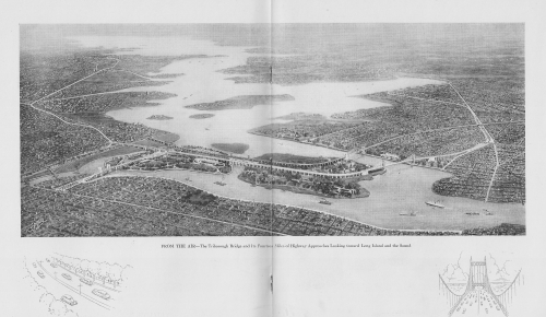
This is a bird's-eye view of part of NYC illustrating a pamphlet on the construction of the Triborough Bridge1, and published in the month of its opening in 1936. The view shows its 14 miles of approaches plus the bridges themselves, all stretching out to the southeast. The perspective here shows the Queens approach at the bottom right, the East River spreading out before us, with Flushing Bay at right; the middle island is Riker's, and the two smaller island with the bridge and connections in the foreground are Randall's and Ward's, and the land receding into the distance is part of the Bronx and then on to Long Island. Overall, it is a pretty interesting map.
.The Virginia Commonwealth University Social Library site quotes two paragraphs from Robert A. Caro’s The Power Broker which provides a good insight into the breadth and depth of the bridge project:
"Here was a project to kindle the imagination. In size, its proportions were heroic. For all Moses’ previous construction feats, it dwarfed any other single enterprise he had undertaken. Its approach ramps would be so huge that houses – not only single-family homes but also sizable apartment buildings – would have to be demolished by the hundreds to give them footing. Its approaches, the masses of concrete in which its cables would be embedded, would be as big as any pyramid built by an Egyptian Pharaoh, its roadways wider than the widest roadways built by the Caesars of Rome. To construct those anchorages and to pave those roadways (just the roadways of the bridge proper itself, not the approach roads) would require enough concrete to pave a four-lane highway from New York to Philadelphia, enough to reopen Depression-shuttered cement factories from Maine to the Mississippi. To make the girders on which that concrete would be laid, Depression-banked furnaces would have to be fired up at no fewer than fifty separate Pennsylvania steel mills. To provide enough lumber for the forms into which that concrete would be poured, an entire forest would have to crash on the Pacific Coast on the opposite side of the American continent. Triborough was not really a bridge at all, but four bridges which, together with 13,500 feet of broad viaducts, would link together three boroughs and two islands."
"Triborough was not a bridge so much as a traffic machine, the largest ever built. The amount of human energy that would be expended in its construction gives some idea of its immensity: more than five thousand men would be working at the site, and these men would be putting into place the materials furnished by the labor of many times five thousand men; before the Triborough Bridge was completed, its construction would have generated more than 31,000,000 man-hours of work in 134 cities in twenty states. And the size of the bridge is also shown by the amount of money involved. With $5,400,000 already contributed by the city and $44,200,000 promised by the PWA (Public Works Administration), the amount promised for its construction was almost equal to the combined cost of all the projects Robert Moses had built on Long Island during the previous ten years." Quote source: http://socialwelfare.library.vcu.edu/eras/great-depression/triborough-bridge-dedication-1936/
Notes:
1. "The Triborough Bridge, known officially as the Robert F. Kennedy Bridge since 2008...is a complex of three separate bridges in New York City. The bridges connect the boroughs of Manhattan, Queens, and the Bronx via Randalls and Wards Islands... The bridge complex ... connects with the FDR Drive and the Harlem River Drive in Manhattan, the Bruckner Expressway and the Major Deegan Expressway in the Bronx, and the Grand Central Parkway and Astoria Boulevard in Queens..."--Wiki https://en.wikipedia.org/wiki/Triborough_Bridge


Comments